Gamification of Physical Spaces/Urban Design (Mo Li's Unity Game & Thesis)
Gamification For An Engaged Participatory Landscape Design Mo LI
A thesis submitted in partial fulfillment of the requirements for the degree of
Master of Landscape Architecture
University of Washington
2019
Committee: Daniel Winterbottom Thaïsa Way
Program Authorized to Offer Degree: Landscape Architecture
University of Washington Abstract
Gamification For An Engaged Participatory Landscape Design
Mo Li
Chair of the Supervisory Committee:
Daniel Winterbottom Department of Landscape Architecture
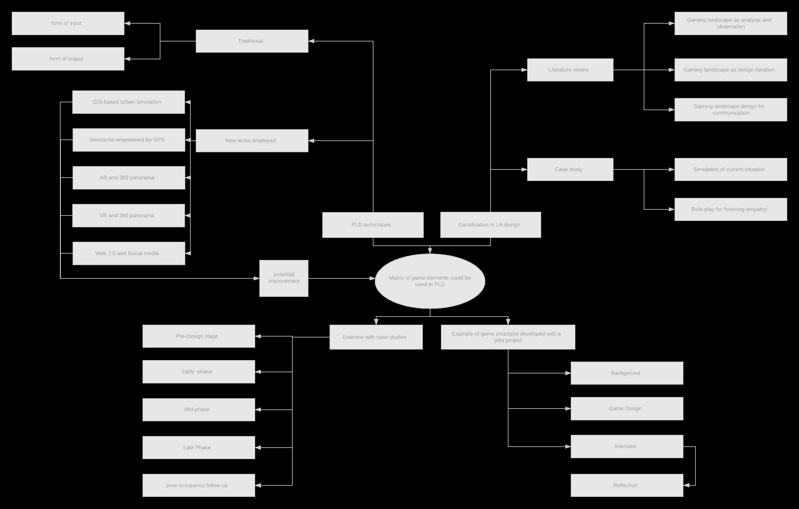
This thesis will explore the potential scenario for the future of participatory landscape design (PLD) through the employment of an interactive approach, specifically gamification. This may provide an alternative perspective as a supplementary tool in motivating decreased participation situation, collecting feedback effectively, and getting satisfactory outcomes in the urban public space context.
PUBLIC SPACE BETA
Gamification For An Engaged Participatory Landscape Design
Daniel Winterbottom Thaïsa Way
ACKNOWLEDGMENT
This thesis has been a process of collaboration. would like to thank my thesis committee members and professors who helped me; all interviewees from professional and academia who shared their insights with me; and PLACE studio for allowing me to conduct a pilot project with the design participated during my internship there. I cannot accomplish this work without their kind help. would also thank my family and friends, and their support is my motivation.
KEY WORDS
Public space design; Participatory landscape design; Gamification; Public engagement; Information and technology.
ABSTRACT
This thesis will explore the potential scenario for the future of participatory landscape design (PLD) through the employment of an interactive approach, specifically gamification. This may provide an alternative perspective as a supplementary tool in motivating decreased participation situation, collecting feedback effectively, and getting satisfactory outcomes in the urban public space context.
Originality/ Value
The active design feedback from busy working/studying residents who participated less in traditional forms of PLD, but their voice is an essential element towards a responsive public landscape design. Few articles reveal the situation of inadequate representation of age groups in the participatory design process for public spaces. This study is exploring the reason and comes up with a potential supplementary solution for this situation.
CENTRAL QUESTION
THE CENTRAL QUESTION OF THIS THESIS IS EXPLORING WHAT MIGHT GAMIFICATION OF THE PARTICIPATORY DESIGN LOOK LIKE — THREE SUB-QUESTIONS LISTED BELOW ARE TO BE INVESTIGATED THROUGHOUT THIS STUDY.
QUESTION 1 QUESTION 2 QUESTION 3 OF PUBLIC SPACE BETA
Study Approach
INFORMING ENGAGING INFLUENCING
Can gaming help people understand the experience of a space through this interactive tool?
Can gaming offer a better approach for collecting feedback? Can gamification increase participation from groups of people who have not participated before, like young people?
Figure Current Issues In Participatory Design
Based on literature review and interview with professional and academic experts to discuss current participatory design techniques used and potential for improvement.
01 02 03 04
Retrospect Of Existing Participatory Design Techniques
Study approach started with literature review of the current situation and techniques used in participatory design, together with a retrospect of game tools used in landscape design field.
Gamification Toolkit For Future Reference
A matrix of game elements and criteria could be applied to gamification of the participatory design based on theory foundation in gamification and environmental psychology.
Examine The Toolkit By Case Studies And A Pilot Project
Examined with cases, including a game prototype developed with a current undergoing real project.
The programs used for this thesis include 3D modeling programs (Rhino/3DsMax); video
Study Approach
2.1.1.
2.1.3.
2.2.
2.2.1.
3.1.1.
3.1.2.
3.1.3.
3.1.4.
3.2.
3.2.1.
3.2.2.
3.2.3.
3.2.4.
3.2.5.
4.1.2.
CHAPTER 1 INTRODUCTION
LITERATURE REVIEW
4.2.1.
4.3.1.
PARTICIPATORY LANDSCAPE DESIGN IS AN APPROACH WHERE STAKEHOLDERS AND AFFECTED GROUPS ARE INTEGRATED INTO THE DESIGN PROCESS, AIMING TO ACHIEVE AN AGREED-UPON DECISION FOR ALL COMMUNICATIONS. 1 THIS IS A BROAD TOPIC THAT INCLUDES COMPLEX APPROACHES AND EXISTS IN MULTIPLE PHASES IN DIFFERENT FORMS. THE PURPOSE OF THIS SECTION IS TO PROVIDE A SUMMARY OF THE WORK.
1.1.Scope of Study
WHO:
This paper proposes to take advantage of the game as a tool to devise novel participation strategies for the benefit of previously less engaged people, to ensure that their rights and needs are fully acknowledged and accommodated.
The groups that might benefit the most from this study are busy young people as they have less incentives to civil engagement. It may be because few of them are property owners and move frequently, or lack of time due to busy schedules, all of which results in their lack of engagement.2 This may also benefit to people who want to attend the meeting but failed due to busy working or accompanying family. This study is proposing a virtual participating approach which may not requiring physical attendance in the future. And gamification as a motivation may help engage anyone who is interested in gaming
WHY:
Why game platforms over other approaches and techniques? Some practitioners have tried to improve participants’ understanding of the design by employing new techniques, like better immersive visualization tool. However, residents still feel they are being passively informed of the design instead of sharing their roles.
From a psychological perspective, a game as interactive entertainment can help to engage the user to spend more time to explore and “learn” more information about the design.3 It could help motivate those who could not come to the open house and still have a sense of being involved and actively sharing roles and responsibilities in decision making.
(Odom 2017) Also facilitate participatory landscape design quality, as well as stakeholders’ satisfaction to a higher level
1 (Public participation n.d.)
2(Walsh, Donahue and Pease 2016)
3(Lenhart, et al. 2008)
1.2.THEORY FOUNDATION OF PLD
1.2.3. When is PLD needed
1.2.1. Why is PLD needed?
Participatory design is a legal requirement for public, which is to provide certain engagement with public participation for decision making under the authority of several federal statutes and executive orders for urban public projects. In Washington state, for instance, this set of regulations includes the Administrative Procedure Act (APA) in 1946; National Environmental Policy Act (NEPA) in 1979.1 Also, each public project is required to have the public engaged, and post on a design commission.
As a responsibility of landscape designers, public involvement attempts to help the city bring about the most satisfactory outcome, building credibility by responding to public needs and concerns before construction.2 The participatory design may be costly if the time and efforts spent could be translated into money, however, the cost of implementation caused by public opposition could be even more expensive. (Public participation n.d.) So it is worthwhile that the cost of figuring out designers’ concern, developing the digital platforms and briefings for PLD, and cleaning up feedbacks collected.
1.2.2. Who is defined as the public in PLD
For most of the city public projects, all the residents who are living around the site or will probably use the space, and whoever will be affected by the project from economic, social/environmental impact can be taken in the scope of the public.3 Also, for some privately owned projects with a wide variety of users, like a big company’s office campus or school campus, the potential users are taken as the public. Based on that, this definition is not an unchanged group or a specific monolithic whole. Instead, it is a continually shifting mass of groups of people in the different situation and different projects. Or objectively, people who feel they will be significantly affected by the project and believe they have the responsibility to contribute something for the project.4 Take the pilot project in Chapter 4 in this study, the public refers to the employees who are majority group who use the space during workdays, so they are the targeted group the participation tool aimed to engage.
Frame design needs and expectation
When designers seek public input of ideas and needs, which takes place in the early stage and will affect the design direction the most. This input is the most important and will decide the big picture of a project.
Inform difficulty and look for acceptance
When designers and government met technical difficulties and seek the public’s understanding and acceptance. While PLD may not guarantee support for a decision, if a decision or action is controversial, support is unlikely without public involvement.
Help decision making
When designers seek public opinions and feedbacks about a design decision in order to help the designer decide on further design development, or sometimes even a change of design direction. This study is more focus on this situation.
1.2.4. The primary process of PLD and the goals for each phase
Information gathering including social, economic and environmental effects of the proposal. It usually to work directly with the public at the very beginning of a project, even earlier than designers joining. This is to make sure public output will be fully considered by decision maker, which is set for further design decision making.1
Identifying concerns and values of both the public and designers, which on the one hand based on their previous information gathering, on the other hand the concerns and difficulty may be found later in the design process, that some constrains may be figured out.
Informing::Acknowledging public the most up-to-date decision and design proposal, help them understanding the problem, alternatives, opportunities, and solutions. A prerequicision of effective communication is to provide comprehensive and objective information about the affect to their future life in the aspects of regulatory, economic and operation. However, sometimes the public are vulnerable to be persuaded by the proposal.2
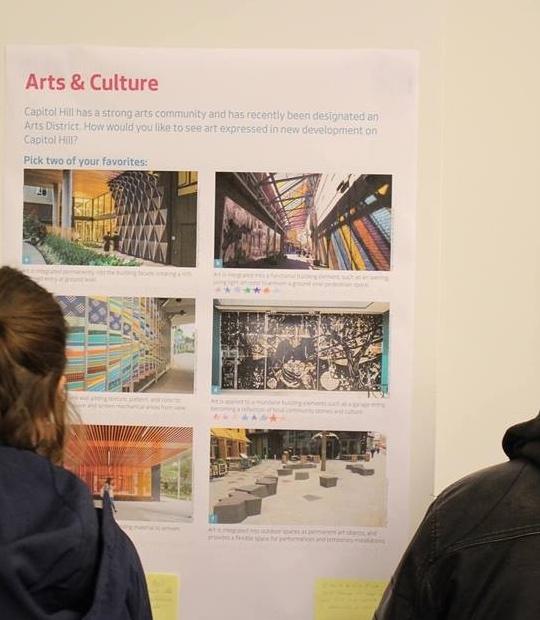
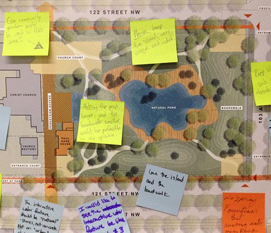
Hearing: In a later phase of participatory landscape design, participants are more passively being informed with the design proposal, just like designers using beautiful rendering to persuade people of the design. Plus, there are limited approaches for people to provide input, like sticky notes participants putting on the design boards, and most are “I like this design,” or “cannot wait to see it.” Designers just failed in collecting effective feedbacks from this process. Can we change this situation and make better use of the 3D digital model than just create beautiful rendering from it?
Responding: Once gathered participants feedbacks, designers are responsible to make residents feel empowered to shape their communities. Let people know how their input will be used in further decision making process.
1(Creighton 1985)
2(Public participation n.d.)
3(international leader in public participation 2018)
4 (Perkins-Gough 2009)
1(international leader in public participation 2018)
2(Creighton 1985)
1.4. LIMITATIONS
1.3.RELEVANCE
TO LANDSCAPE ARCHITECTURE
LANDSCAPE ARCHITECTURE PRACTITIONERS USUALLY ARE MOTIVATED TO ADVANCE THE INCLUSIVE BUILT ENVIRONMENT TO INCLUDE THE EXCLUDED, TO PRESERVE CULTURE, OR GIVE SPACE TO ETHNIC DIFFERENCE.
As governments and urban designers around the world often struggle to achieve socially sustainable neighborhoods in urban environments due to a lack of integration between councils and the public for plan-making, limited public participation options and inadequate representation in the participation process.1
Since half a century ago, public participation shifted design process from a top-down attitude, participatory design has become a vital part of bringing about sustainable development through the critical information exchange among stakeholders.2 In this context, the public spaces serve the public, the collaborative work has changed the situation of solely relying on a bureaucratic monopoly of decision making.3 After that, landscape design practitioners use participatory landscape design to help empower communities reclaim their rights, turn the needs of the residents into action, and thus help improve design.4
1 (Foth 2009)
2 (Hester, Halprin and Mullen, Interview: Lawrence Halprin 1999)
3 (Public participation n.d.)
4 (Hester, A Refrain with a View 1999)
Due to the complexity of PLD, the purpose of this study is to discuss and provide information about facts and trends to inspire novel public participation. Some limitations need to be acknowledged before going over this study:
Motivation: When well combined with mechanics, dynamics and aesthetic elements, the gaming experience could be a motivation for people to play and participate in the PLD. However, as a supplementary tool, this game-like platform is offering an alternative approach to help to engage those people who had difficulty in attending the community engagement event. So the motivation, as a pre-requisite, is that the users have the willingness to share their roles and responsibilities in the decision-making process first.
Common ground: Some decisions are identified and built upon in previous PLD process. As a result, the big picture of the design proposal, like land use and master plan, has already determined in earlier steps. Therefore, this study may only apply to design details decision making.
Aesthetic: Different game genres may be developed in different stages and/or for different projects. Roaming in the first-person perspective, immersive, and high-quality rendered context sometime could help offer a clear vision of the space, but playing a text-based game may need more imagination. As a result, it could be either over-beautified or lack-of-detail world for some players.
Accessibility: This tool may only accessible for the group using the internet and comfortable with gaming. It sometimes could be challenging for a user who has no experience in a specific game genre, or with sensory disability,
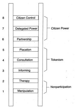
Public advocacy: To what extents could this study help the public’s advocacy in the PLD? Based on the ladder of citizen participation typology by Sherry Arnstein,1 (see figure 1-1). A total of eight levels of participation are organized in a ladder pattern, each level corresponding to the extent of citizens’ power in determining the end product. The lowest one “manipulation” is the worst situation, which means the powerholder intended to manipulate the result with a substitute for genuine participation. Most of the PLD efforts designers taking recently are falling to either “informing,” or “consultation.” The study of this research is not trying to improve the public participation to the extent of “citizen control” with a huge leap, but hopefully reach the “placation” level.
The idealist of all possible situation is that every single project is accomplished by achieving successful PLD in every phase and on each decision making. However, it is almost impossible as there is no way to respond to some groups of interests without offending others. Understanding the designers and government’s effort and difficulty in balancing the solutions in financial, legal and technical constraints is also a way of engagement, the public will be pleased with the result which even not developed towards their proposal.
1(Arnstein 1969) figure 1-1
CHAPTER 2
REVIEW OF TECHNIQUES USED IN PLD
LITERATURE REVIEW
2.1.Phases and techniques
During the process of participatory landscape design, a collaborative ideas and values are generated by the public through a series of interaction with design professionals. As this process usually take time differently project by project, PLD is roughly divided into three thematic phases in chronological sequence through the design process.1
figure 2-1
For the first phase (figure 2-1), including pre-design phase and early design phase, designers are more like interviewer, to get more input from public’s image of the place. Site understanding is the most important goal in this process for both environmental as well as social context.
figure 2-2
The second phase (figure 2-2), including designers offer several alternative concepts to get publics’ ideas of preference.
figure 2-3
1 (Peña 2017 )
The third phase (figure 2-3), designers are more like presenting the matured design proposal with digital/physical model or graphics, to get specific feedbacks from the public.
Sometime PLD may not strictly be divided in this way, for instance, some design firm would like to follow up the post occupancy and get lessons learned, for a
2.1.1.
PLD framework
PLD project should be planned according to the decisionmaking hierarchy in order to plan it in the most effective way.1
2 The specific steps that need the public’s input should be defined in both larger image, like land use proposition, and design detail, like types of amenities. Take the pilot project in Chapter 4 for instance, as this is a private owned project and the surrounding office buildings and café cannot be changed. This is the common ground of the land use, decided by the property manager and not open to free discussion. But the design features within the site, like furniture and water features, how to use them and when to use them, are welcoming active comments. However, an overall framework for a PLD plan is not enough. The next section is to introduce the basic techniques that should be filled in this framework.
2.1.2. Basic techniques in PLD
PLD is never a single event, but a series of coordinated participatory activities, which include a variety of techniques.3 This section will be further subdivided into two categories: 1) the forms of interaction and meeting, and 2) the forms of collecting feedbacks.4
2.1.2.1. the form of interaction and meeting:
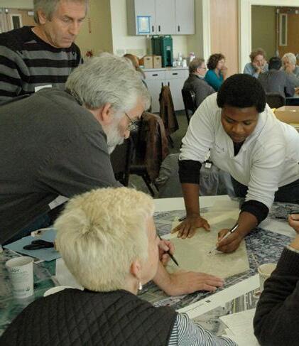
Onsite: workshop, charrette, open house, public meeting and hearing, round table, all of which are effective for a smaller group of people to achieve a sense of being involved and actively participated. On the opposite, lecture, filming or showing video and board, which are ways for effectively informing a larger group of people in a short period of time to achieve high efficiency in information giving, but may not effective for information receiving somehow if not well organized. Besides, this way lack of interaction and people will feel less being involved or sharing their roles. Citation?
Offsite: informational brochures, polling, and other media. Based on the size of the audience expected, like if the project covers a larger population group, an off-site format will be more effective as the constraints of room for holding the meeting, and the number of facilitators that helping running the meeting.
1(Creighton 1985)
2For example, if the public is dominant in a project, it may take priority in PLD
3(Green 2018)
4(Daniel 2001)
2.1.2.2.
forms of collecting feedbacks
The choice-based approach is based on a series of Stated Preference surveys are the most common methods for collaborative decision-making support tool, which are used in many disciplines including marketing; transportation, environmental and health-economics; and landscape and urban planning.5 In the PLD practicing, this approach is applied and acted as offering different alternatives and invite people to make a comparison and make a choice, like “please choose the proposal you like the best?”
Rating and ranking based approach is also a widely used approach in survey question settings, which includes several different levels of positive or negative attitudes towards a specific aspect in a proposal as this approach is more precise statistical approach compared to the “yes-or-no” questions brought by the choice-based approach.
2.1.3.
Conclusion:
The techniques listed above are not exhaustive as techniques change case by case and time by time. However, this catalog of tools is needed to be fully understood as they are the most classic that could be applied to most of the cases, plus, the new techniques are usually applied based on these basic ones as an improvement, not iterating.
The approaches mentioned above tend to be passive, which means inputs (presentation of the proposal) more than outputs (audience feedbacks). This could explain why young people barely show interest in public involvement in these approaches and less motivated to give feedback of, for example, a new development proposal. This directly leads to a result that their needs – in terms of housing, basic services, and public spaces – are not considered in urban planning policy and implementation.6 For the next step of this study is that we need to figure out a new way in balancing dealing with both a massive group of people to reach and guarantee the effective participation or the sense of being involved.
5 (Pattersona, et al. 2017)
6 (Commonwealth Secretariat 2017)
2.2. Recent approaches of PLD embedding technologies
“WE HAVE MOVED FAR AWAY FROM THE EARLY DAYS OF BATCH PROCESSING COMPUTING IN THE 1950S AND 1960S.” -(BRAIL 2008)
The last decades, the rising importance of employing technology in landscape and urban planning research is based on the fact that we are living in an era of information and technology, which helps unite people wherever they are. The concerns and interests of citizens are coming to the forefront nowadays with the awareness that a livable city also consists of citizen input and feedback.1
Below is a brief introduction of selected approaches employing technology, and their application and achievements. The advantages and disadvantages of each approach are also discussed. In terms of the classification, it was hard to divide in a particular rule as each of them has some common attributes with each other, so the examples raised under each category may overlap with one another.
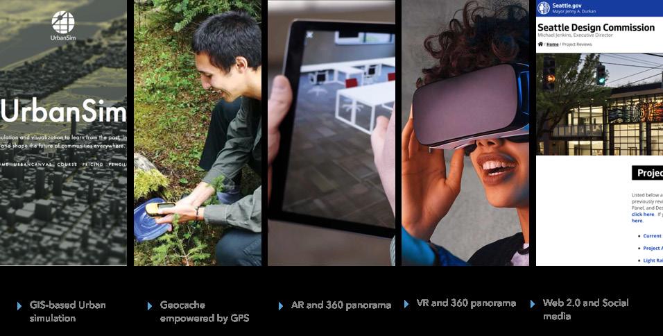
2.2.1.1.GIS-based Urban simulation
Cases: UrbanSim; CityEngine by Esri; CityScope by MIT’s Media Lab
This computer-assisted planning and urban design technology have been emerging in the last two decades with facing the problem of difficult to manage increasingly enormous and complex urban infrastructure system. They are born to solve the efficiency issue by combine with technology, transparentize the operation of planning work for future decision-making processes like making investment, development, and policy change within the built environment realm.1 Data science, simulation, and visualization is this model’s most important factors. They can help presenting the past and future based on the input data, and participants and decision maker can view it in a dynamic way of the different outcomes of alternative proposals.
CityScope2 for example, is a programmed system that looks like bricks that simulating the masses of buildings. It works with overhead projectors that cast colored beams onto the masses.3 When capture the data from Twitter or other social media, this model can present the dynamic change of future land use, transportation, the economy, and the environment. This model is a handy tool in predicting larger scale planning with realistic outcomes.
The workflow: Generate the whole site of the project, use an ArcGIS Online subscription to clip out and import satellite imagery and 3D terrain, or import street and building footprint data from OpenStreetMap if working on a streetscape project, to generate a background environment. Then, work with compatible formats and integrate with other 3D tools, as it supports most of the 3D modeling file types.4 You may measure, visualize zoning in 3D or generate instant reports, to see a different outcome in different alternatives.
Keynotes this technique can be used in a more precise or datadriven design when it is necessary, as incorporated mathematical, computerized models for predicting urban structure, land use patterns, economy, traffic flow in a broader landscape. Besides, the full interactive interface would help participation to test the alternatives and different outcomes for prediction.
Keywords Data; predicting impacts; interactive, virtual environment serves a built environment
1(University of Washington. Center for Urban Simulation and Policy Analysis. 2008)
2(Preece 2009)
3(Schlickman and Domlesky 2017)
4(Esri CityEngine n.d.)
2.2.1.2.Geocache empowered by GPS
Cases: NAPA, California Department of Parks and Recreation
The first geocaching activity occurred in 2000,1 Geocaching is like a combination of real world and virtual treasure-hunting activity. This is supported by global positioning system (GPS)-that allow people with device to navigate to find a specific object, or “geocache,” that has been hidden in the designated location by gamemakers.2 Pokémon Go as the most famous game that bringing Geocache’s name to the public, some other non-game APPs like Geocaching Adventure Lab the app helped some parks and recreation department to bring people outdoors and give feedback on current situation.
Keynotes: it gives outdoor enthusiasts a chance to explore the world (in the future this dynamic can be brought to a virtual context), visit new places and explore off-the-beaten-path locations, all while testing their knowledge and skills. Recreational, technologyenabled hobby is helping curious treasure seekers to keep the spirit of exploration alive.
Keywords: immersive; real world; competing;
2.2.1.3.AR and 360 panorama/3D model
Cases: UrbanSim; CityEngine by Esri; CityScope by MIT’s Media Lab
This mixture of technologies allows participants view a 360 panorama photo (a series of stitched together spherical images that a user can virtually turn around to create the illusion of real space but cannot move around freely.) on site just using a mobile device which usually empowered by GPS. In the rendering they see an overlap of a real world panorama photo with digital objects rendered into the physical world.
The workflow: View existing site conditions and recorded as pano-phono. Using the program Kubity to overlay a 3-D computergenerated model can be placed at the real site at 1:1 scale, or rendered on the panorama photo from Google Street View, casting a shadow, and can be seen from different points of view with existing surroundings in a panorama, flythrough video, or rendering approach. Finally, export a rendered 360 panorama photo for viewing on a smartphone.
Keywords: portable; real world; 1(Groundspeak, Inc. 2000) 2(Frank 2017)
2.2.1.4.VR and 360 panorama/3D model
Cases: NAPA, California Department of Parks and Recreation
This mixture of technologies can realistically construct virtual scenes that people expect by building various models needed in three-dimensional scenes, such as buildings, trees, grasslands, roads, and so on. VR technology has been widely used in landscape exhibitions for visual communication.
This technology is divided into two modes: the mobile-end and fixedend VR. Both the fixed-end VR and the mobile-end VR have their own superiority and shortage. It should be selected according to the actual situation in the exhibition. The emerging all-in-one VR can better integrate the advantages of both, which should be widely used in the future as the cost dropping. The participants pay more attention to immersion, interaction, and amusement in the open house session or any onsite PLD, so the fixed-end VR is more attractive to people, professionals need to assist them recognizing the environment to get a better experience.
Different projects have different characteristics, so exhibitors should choose which VR mode to apply according to the characteristics of the project. Through the mobile-end, VR participants can directly watch the mobile phone by scanning the QR code, which cost less in reaching to a large group of people.
The workflow
1)Modeling is to use the Sketch, Up Rhino, 3DMax and other modeling software to build a 3D digital model in a computer, transform the design into a physical space model
2)Rendering is the process of visualizing the model, relying on V-ray, Lumion, 3DMAX and other rendering software to render the light environment and material model
3)Display to the users is completed by rendering model imported to the device side and displayed using the VR device described above.
Keynotes: Through the use of the virtual reality simulation environment, it was possible to systematically control the visual elements and allows a complete tour, however, it has a more complicated equipment requirement, at least a portable headset. The evaluation of the other three 360-degree experience mode is basically similar, but because the scale of the project is different, it is found that the small-scale scenes in the exhibition are better reflected like the actual scene. Large-scale projects use more of a larger bird’s-eye view and pay more attention to the overall atmosphere, so the immersion in the exhibition may not be as well as the small-scale projects. The
360-degree panoramic photo is an entirely realistic shooting for the built project. It is highly attractive to visitors who have not been to the site, but not to whom has already been to.
Keywords: immersive; interactive; realistic
2.2.1.5.Web2.0 and Social media
Cases: Better Market Street project, City of Boston
Some studies have found the prospect of augmenting public participation through the use of social media and beyond applications and government-supported websites, like design commission, thereby capturing a wider audience of participants.1 Take SIMMER, for instance. This is an unofficial website everyone can get access to upload, host and share their 3D content in WebGL format;2 also, other people can view the game or asset or write comments about a media whatever it is. On the other hand, Boston.gov is the first government supported website that engaging the public in new city development since 2010. This website explores and tackles experiments and prototypes that cover a range of urban topics, includes everything from the future of mobility to City infrastructure to collective well-being, but basically, it is also a host for some sorts of media for public participation and could be spread out through social media.
Keynotes: Web 2.0 offers the most compatible platform to each of the techniques discussed above can be supported, host and spread social media, for any form of media produced by whoever explore, experiment, and evaluate civic innovation projects across departments and throughout the city.
Keywords: interactive; portable; useful for a massive group of participants
2.2.2. Conclusion
Several emerging and important models and tools take advantage of immersive technology, based and beyond government supported social media, to facilitate community connection as design support systems. Based on the current situation of 3D visualization tool being employed in the participatory design process, most are more like persuading residents of design proposal instead of intending to capture their feedbacks. Besides, these tools are not perfect at balancing cost-effective, immersive experience and interactive incentives. VR has the best immersive effect yet requires expensive headset, which is not affordable for designers when reaching out to a large group of people; A 360 Panorama photo is comparatively easy to develop but only suitable for standing at a fixed spot to look around rigidly, which could not offer people to roam freely in the space. In order to evaluate the use of these technologies, six evaluation indicators were derived and been divided into the perspectives from both designers’ and participants’. These include immersion, participation, operability, and convenience. See figure 2-4.
Immersion is the degree to which visitors participate, integrate, and feel in the virtual environment. The degree of participation refers to the degree to which visitors can interact during the experience.
The operability refers to the ease of operation of the device by the visitors
The manageability reflects the difficulty of building the scene in an exhibition.
The Cost of developing refers to the estimated monetary cost of software and hardware, and also the time investment and efforts cost the design professional learning new software.
The Cost of using refer to once the participation platforms are produced with software, immersive environments require hardware for viewing.
And we can compare and analyze the techniques discussed above in this evaluation matrix (figure 2-4)
Urban simulation
empowered by
1(Fredericks and Foth 2013
2(Balsamo 2017)
2.2.3. Trend and opportunity
Better understanding through information visualization:
Although the Web 2.0 has already helped in achieving connecting larger population, the communication based on fully understanding of the proposal seems to be a problem that need to be addressed first. The representation of landscapes is evolving from images to computer simulations from offering a flat rending, a 360-photo of the proposal, a flythrough video, and then VR walkthrough in the 3D model freely. It is remarkable from this trend of iteration, that audiences tend to receive the information most effective when in an immersive and interactive way of exploring. In the future we can help translate ideas to be more engaging, lengthening the attention span of users as they virtually explore the space that can be more realistic than a typical flat rendering.
Better immersive experience:
Designers can roam or fly through the 3D model when designing the space. We could help the participant/non-professional to view the proposal in more detail too, in order to allow them for a more accurate assessment of conditions. The trend in bettering the immersive experience for the participants is to gear the tools up to test assumptions and unearth questions or problems in the design process.
Dynamic of change:
Offering a clearer vision of the alternatives over time is always the core efforts designers and planners are making, as the public cannot evaluate a proposal without having been adequately informed with the consequences. For instance, state-a-preference is a widely used technique in public space design, defined by the presentation through images or physical model of proposals. This technique sometimes can evoke advantages as greater realism in tasks, but it also has drawbacks like unintended information affecting respondent choices.1
Stimulate a more proactive way of participating
UrbanSim and similar technical documentation tools tend to provide factual information in a larger scale. This civic discourse can help inform the public to figure out the question: “how could this decision affect me?”
1 (Pattersona, et al. 2017)
Compatible:
In each of the techniques, there is also some description of how they could be leveraged by combining with other technologies. In order to draw a clearer image of this, two examples are offered, but it’s not limited to these examples, more models of the combination of techniques are open to discussion.
Example 1: the GIS-based Urban simulation could be more immersive by diving people into a virtual 3D city with the ArcGIS 360 VR app, to let the participants communicate in the VR experiences. The app probably could be hosted on ArcGIS Online by the city, which is taking advantage of the Web2.0 and Social media.
Example 2: Recreational, technology-enabled hobbies like Geocaching are helping curious treasure seekers to keep the spirit of exploration, not alive, but in a virtual open world instead. And this virtual world could be a design proposal that modeled digitally geared by CityEngine, and the whole treasure seeking experience is completed with a headset for interaction, instead of using the mobile phone. Furthermore, this exploration can collaborate with massive multiplayer wherever they are in the real world.
Affordable:
Besides the cost of software and hardware for developing and hosting the participation tool, the time and efforts invested by both developer and the participants/users are also remarkable. How to make the tool cheaper and easier to learn will be one of the potential improvement directions. The future of participation tools need to have high hardware functionality, low time investment in learning software, and a relatively modest cost.
2.3. Potential approaches to improve PLD
2.3.1. Gaming as a prospective approach for engaging PLD
Given that 97% of American teens have game experience,1 and 60% of them play video game on a daily basis,2 there is a tremendous opportunity to engage young people in participatory design process within the framework of video games in the future. Also, as they live in a global digital participatory culture with instant access to information with the internet, the iteration of PLD could become a way to take advantage of this trend. The different expectations associated with gaming environments cause players to act differently than they would in the real world.3 The potentials listed below indicate game mechanics can be good add-ons for participation process:
Express freely: Tools like the virtual chatting room allow people to go “behind the screen” where people are more willing to express real thoughts. In this way, designers and governments could review more bad side of a proposal that people may be discussing other than “I like this idea” stick notes.
Capture dynamic behavior: A game engine or host usually can capture and document players’ in-game behavior. When we get the database of a massive group of players’ records of their movement in an open-world or sandbox exploration game, tracing and mapping of the overlap of their movement will be clear, and help to figure out the potential circulation of a space.
A sense of achievement: Participants need a sense of being taken seriously, they want to know their input matters. The evolution of a virtual environment as a co-design tool could be captured as a reflection of how their participation affects the decision making results. Thus the participants can get a sense of fulfillment of making a contribution to these projects and achieve better participation satisfaction among different parties.
See and explore space using the first-person view: First-person video game is user-friendly for people who are already used to using this video game mode to walk and interact in the 3D model. Even for people without gaming experience, this mode of playing is an immersive way to simulate exploring in the real world.
Interaction: A game format can make PLD more fun because players can interact with the proposal in a hands-on way, like material replacement, object grabbing and placement, and even do some annotations in-game context.
Information visualization: Some of the information guidance tools like wayfinding, plant information display and smart tour map can be found in the game user interface (GUI). These tools can provide information dynamically, helping players learn as much as information of the new space in a short period of time.
Reach greater participation: The participation platform based on browser, Apps or any other forms of applications could easily access the PLD system, to engage those who could not attend in-person sessions.4
1 (Lenhart, et al. 2008)
2 (gamesforchange.org 2019)
3 (Ong 2018)
4 Walsh, Donahue and Pease 2016)
CHAPTER 3
GAME AS A POTENTIAL TOOL TO DEVISE NOVEL PLD APPROACH
BUILD A MODEL
3.1.Gamification in landscape architecture
When software became prominent in the evolution of virtualizing the physical world in new ways, it is introduced in the landscape architecture profession and academic, which is almost impossible to be completely software agnostic today.
1Designers use that virtual space to imagine what is possible back in the physical world and to build a reciprocal set of relationships. Not just to visualize design concepts for more efficient communication, but to push designers as far as possible to re-imagine the built environment.2 Information and communication technology (ICT)3 and interactive entertainment even accelerate this trend, like games which have a considerable culture and influence with video games in contemporary society, can do more than visualization.4
As mentioned in chapter 2, some techniques are already employed in participatory design. This chapter as part of the literature review, focusing on studies of the current landscape design process that employing game design or tools to achieve a responsive design. We can get a closer look in this chapter at how and why designers choose this medium with evaluation and analysis of the application of games as a design tool.
3.1.1. General introduction
“Video game culture is one replete with slang, acronyms, and buzzwords.”5 It may be hard to understand some of the terms without any gaming experience. In order to make it understandable for the rest of the thesis, and to make the findings of this study more accessible to the designers, community and any group that has no gaming experience, this section serves a guiding tool to explore the game elements which this study is exploring more easily.
Also, in order to focus on what related to this study and landscape architecture realm, the game genre, and other elements are narrowed down deliberately to a catalog of what will be used into facilitating PLD process.
1 (Cantrell and Michaels, Digital Drawing for Landscape Architecture Contemporary Techniques and Tools for Digital Representation in Site Design 2014)
2 (Cantrell 2019)
3 (TechTerms 2010)
4 (Seibert 2019)
5 (Ong 2018)
3.1.1.1.Gamification
Gamification is the use of game elements and game design techniques in non-game contexts, provide rewards and engagement for users.1 It usually works under the matrix of points-badges-leaderboards (PBL) framework.2 Each of these elements can contribute to other game mechanics. Gamification has already being widely used or applied in other professions, especially product design to engage user and improve user-stickiness.
Points measure a user’s achievements compared to others. In the game, points are usually presented by keep score, determine win states, connect to rewards, provide feedback, display of progress, data for a game designer, and fungible. Badges are reward achievements visually. Like representations of achievement, flexibility, style, the signal of importance, credentials, collections, social display. Leaderboards organize players by rank. It could be feedback on competition, a friend-relative variant where players can compare to people they know, or capable of de-motivating players when they see other players are too far ahead for them to catch up to. The Figure 3-1 is an example of how gamification is used in product design industry.
Figure 3-1
1 (Kim 2018)
2 (Game Master 2017)
3.1.1.2.Glossary of terms
GUI: refers graphical user interface: which refers to any digital interface player interact with. In this study, GUI especially means the game’s user interface.
Exploration Games that allow player to roam around and exploring in the game world and let players to find the hidden treasure.
First-person: Refers games that have player view the world with a first-person perspective,
Unity: It is risky to say a specific software is helpful, but currently Unity is a popular game engine that allows people without complex game developing the experience to build a navigable real-time environment. A tool as Unity includes physics simulator, artificial intelligence, animation, lighting, materials. They can all be built out to a number of 3D modeling and animation platforms. This study is only going about it in a very landscape architectural fashion.
MMORPG: Stands for “massively multiplayer online role-playing game.” This kind of games allow groups of people play at the same time and interact with each other, like chatting, racing, and cooperation. Role-play mean the player is play by acting someone else or even other creature in the virtual world.
NPC: NPC stands for “non-player-characters.” This kind of characters are designed by game developer and cannot be controlled by players, but NPC can still interact with or react to specific game objects.
Open world: A game with big world map for exploring without the restriction of tasks and quests, or the game environment where the player can build new game map and play in it. Like Red Dead Redemption.
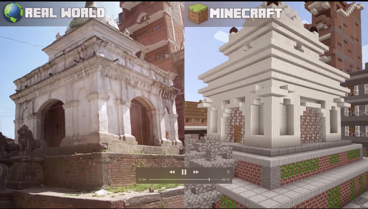
Sandbox: A kind of games that allow player to build new map and edit the original map freely. A well-known example is Minecraft.
Side quests: The missions and tasks that are not affecting passing the game, sometime these side quests are only for better informing the story, some are for improve the player experience.
MiniMap: a small map always showing on top of the main game interface, which mainly exists in a sandbox or open world game which help with way-finding for exploration.
Controller: which includes axis (mainly for controlling of view and movement), panel (usually for quit or get the map) and buttons which for confirm and other functions according to different games.
Script: coding /programming of commands to connect all canvas, graphics, models, and animations, make them an integrated program or a game.
Rigid body: in-game engine, a rigid-body refers to a game object that does not affect by other game objects.
Collision: in-game engine, a collision is the opposite of rigid-body. Collision is a combination of pieces and will split into pieces once affected by other game objects.
Pre-fabs: This refers to a built object that may be used more than once. The object could be canvas, graphics, models, and animations.
3.1.2. Cases of gamification applied in design
Drawing, modeling, and animation are all about landscape architecture expression, which serves as a mediator between people and the environment they designed. It also has versatility in application of the design process: from site analysis to iterating through designs, and finally, to client communication. As well as its versatility in building multiple platforms: from a desktop simulator to virtual reality, and then even to augmented reality.
In this part of the literature review, we could walk through a number of different projects. beginning with projects that dealing analysis and observation, and then moving into iterating through designs, and finally, towards more outward facing client communication.1 This process is not a linear process because a lot of feedback going throughout this, but an entangled process that many design alternatives are tested.
1 (Seibert 2019)
Figure 3-2
Figure 3-3
Figure 3-4
Gaming landscape as analysis and observation
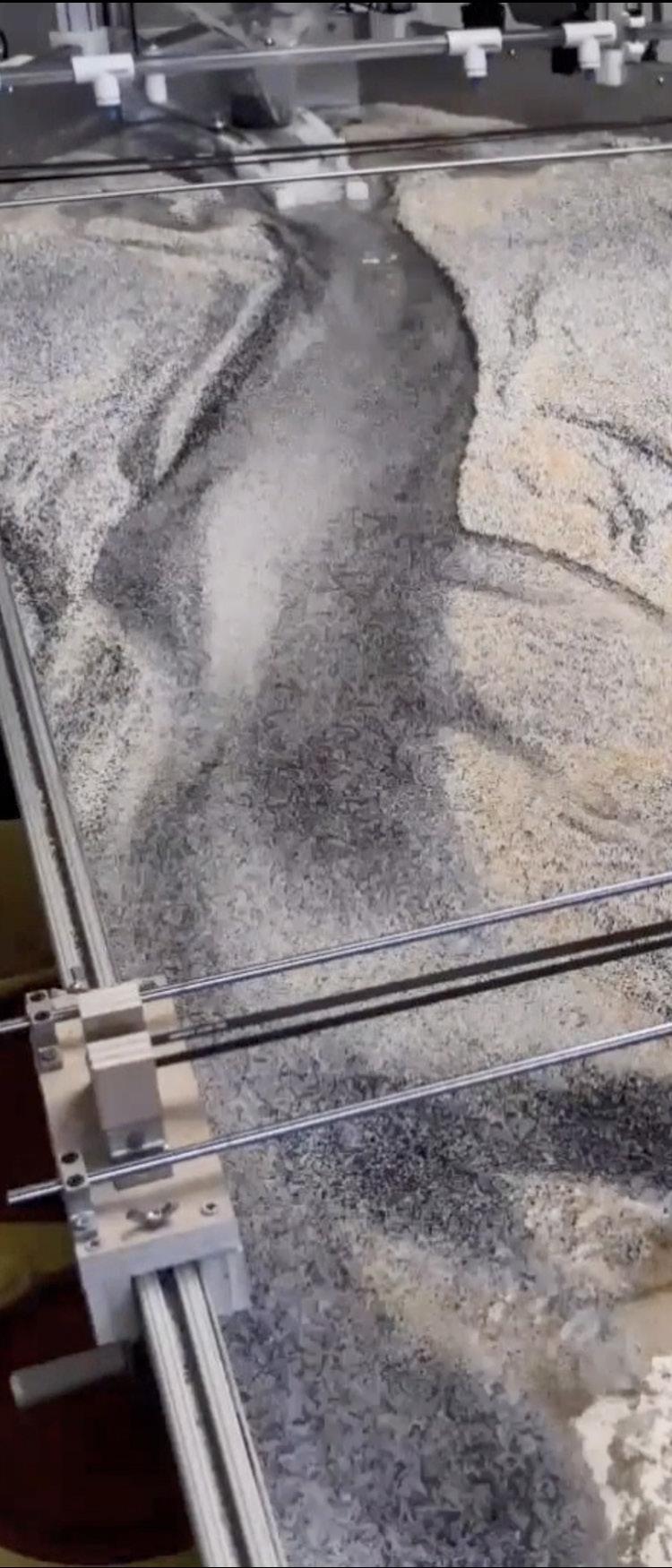
Case: Sandbox Simulation of waterway design impact1
Microsoft Kinect usually used by Xbox, for playing video games. In this case, Bradley Cantrell at Harvard GSD in 2014, use this tool to pick up sections when moving the ultrasonic sensor across the sandbox physical model.2 See Figure 3-2.
By reimagining the link between data and virtual space of the laboratory or the model, this game tool is used to create an environment to capture a virtual territory, which can help designers reimagine the relationship with large scale systems and environmental processes. During the process, designers can also modify the water flow in real time and see the results. The water flow is running faster than real time just for a way of visualizing the point cloud coming off the ultrasonic sensors to cut sections.
Another project is working with virtual sandboxes, still using Microsoft Kinect, to manipulate the landform simply with hands that the sensor can capture their movement. A virtual model with projected slope data and hydrological data over. By recording this to a database that designers can then export 3d files in order to work with Rhino at any stage in the process, as well as be able to replay and review those visualizations.
Both these two projects are trying to develop a physical design method with a game tool, to interface dynamic process which is not just numerical modeling and the computer output, but something designers can interface directly.
1 (Cantrell, Holzman and Darden, Land Printing And Sediment Modeling Infrastructures 2014)
2 (Cantrel and Holzman 2016)
Gaming landscape as design iterating
Gaming landscape design for communication
Case: Fletcher studio David Fletcher described how the landscape encouraged behavior from the player by drawing their attention and framing certain viewpoints in The Witness:3 “A strangely shaped stone or plant, might be placed in a certain location, to encourage a player to desire one path over another, or draw them to an area in order to view a symbolically significant object. Near the entry, for example, a red bush was placed so that the player would be drawn towards a knoll. From that view, framed with a stone, the player sees the Mountain, which represents the end and more specifically death.”4 See Figure 3-3.
There is something that these cases brought up cannot be done by traditional design approach, like a pen of paper. As a lot of the things we design as landscape architects are part of a dynamic system, and how we show up on the visualization should also be dynamic. Moreover, that is one of the critical things that immersive technologies have to offer us.5 For instance, a real-time rendering engine can change the time of day, so before rendering out any final images, we would be able to go back and forth to see the entire dynamic experience. Also, as the time of day is accelerated, like one minute is equaling an hour, this enables people to see through an entire day on the site, to get a full experience. What is noticeable is that most of the designers take this process as an added cost, and they make this exploration done by knowing what they were doing. 6This process should not be situated as an end, instead, it should be an exploration that makes designers to manipulate the space by going back and forth.
3 The witness game
4 (Ong 2018)
5 (Sargeant 2019)
6 (Sargeant 2019)
Case: CBRE build7
It can be hard to communicate how a park, or neighborhood will feel during the participatory design process. A game-like experience embedded into the proposed 3D site model can be a plus especially in the later phase, as it can help the non-professionals have a better understanding of the design proposal. See Figure 3-4.
This platform is basically serves the co-design for private-owned public spaces like office buildings, it makes floor plans interactive, allowing anyone to experiment with the possibilities of a space and explore their layout in 3D. They could also custom model of any building and then host the model online for exploration. The result is a beautiful, interactive tour of buildings before they’re built and the client can be fully immersed, as opposed to looking at a 2-d representation pinned up on a board. This case is the first project that have 3D tour simply displayed with browser, without any equipment requirement.
It also helps communicate the cost dimensions in this way of presentation, to make it being able to look at the materials installed helps the decision making.8
3.1.3. Case study: gamification applied in landscape
design
This study interviewed an MLA student at the University of Virginia over their projects which incorporated game elements. Two cases are especially exciting, one is an experiment of visualization of sound in a game engine, another is having player role-playing hare at a polluted site. Both of these two cases are trying to foster players empathy of the site.
space, we as designers can easily gain empathy and begin to derive new types of design approaches.
3.1.3.2. Simulation of current situation
Case: Simulating Experience -Sensory Downtown Mall (See figure 3-6)
7
3.1.3.1.Role-play for fostering empathy
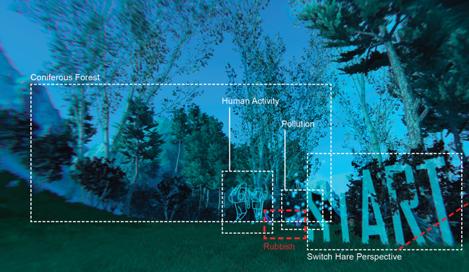
Case: Entanglement -find rubbish (See figure 3-5)
Habitat: The flora and fauna of the Himalayas vary with climate, rainfall, altitude, and soils. In the hare habitat which in the coniferous forest (elevation from 2000m to 3000m). The Hima-layan hare is a medium-sized breed of rabbit. This kind of hare lives in the mountainous mixed decidu¬ous and conifer forests of the eastern Himalayas.
Problem: The natural environment and wildlife that are se¬riously threatened by the rubbish left after human camping. In this project, the particle effect shows the environmental impact of chemical substances gener¬ated by rubbish decomposition.
Perspective: This project starts with a human perspective. As the player enters the trigger box, the position of the start marker appears, and then human perspective switches to the hare perspective. Hare can only see blue and green, so the scene of hare view is only blue and green. This hare perspective will contin¬ue when the player through the site. A player could see rubbish left after human camping in a hare perspective.
In this modeling environment, it isn’t the one that simulating any specific place, but trying to mimic the processes a hare would see in the physical world. As we work with this perspective, virtually in this
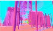
Wanyi: “When walking through the downtown mall, we want to unpack the relation¬ship between space and the associated perceptions of the city dwellers them¬selves. The compression and openness of space give a different sense to peo¬ple and direct them to experience the area. And the sound also strengthens the engagement between the space and people. In this project, we abstract all the senses, including visual and audio, to simulate a dynamic and sen¬sorial world. Not only the materials and physical objects but also the senses shape the sequence and perception of the space.” 1
This project is leading by Bradley Cantrell, by using game engine as a tool for phenomenological investigation, to express an idea of openness and enclosure as moving through a sequence of the downtown mall in Charlottesville. Though the use of 3d modeling program, students in this studio can get some insight into the different moments of openness and compression.
This abstract, two-dimensional look in a 3d form with a fully navigable sort of experience that serves as an investigator or exploratory tool, to understand the movement or the sequence through different spaces. The most interesting part of this case is the game aesthetics, and the figure 3-1 below is how the author expressed the visualization strategy used for this game. The green particle clouds are some audio recordings that they took on the site of conversations or passing by a restaurant. Unique ability to interrogate some of their assumptions, as well as generate new formal ideas.
1 (Li 2019)
3-5
Figure
visualization strategy screenshot
color This dreaming and candy color expresses that an unreal world and makes the happy atmo-sphere prominent. columns and canopy
The various thickness, transparency, and height of columns show the degree of com¬pression and openness between buildings.
corridor The perpendicular corridors with fluctuat¬ing particles represent how pedestrians go through the downtown mall.
particle system The particle system represents the sounds from the theater, cafe, the street artists, as well as natural music, attract and lead the players to experience the space.
marker Combine marker and game scene to express design intent. Markers guide players to follow the game path
3.1.4. Conclusion
From the literature review in this section, we can figure out that although game elements are applied in either design, visualization or communication process, designers still tend to investigate most of the time in vegetation, time of day, and weather and things like atmosphere qualities.1 Professional goals often limit landscape designers like their game world often need to work within either city zonings or clients’ budget.2 All of these reasons are inevitable leading a game environment created by landscape designer that less fun in some aspects but stylized in aesthetic aspects.
3.2.Gamify Participatory Landscape
Design
Gamification as a tool to boost user engagement is already being widely used in other fields, like product design. However, it is still unexplored in participatory design process. This section will serve as a reference for professionals, and academics looking for systematic ways in gamification to push the boundaries of landscape projects and seek inspiration for participatory design.
3.2.1. Theoretical foundation
The reason why employing gamification in participatory design based on several theories, especially environmental psychology. Below is a brief analysis of selected aspects that support this research directedly and indirectly.
Gamification as motivation of exploration
Kaplan asserts that “humans are attracted to scenes of mystery and complexity.”3 Bitgood claimed that “users are motivated to investigate all significant stimuli in an environment.”4 Take a game interface for instance, when the camera is facing a game object which suddenly lightened, players will be curious about it and then interact with the game object. The attraction of unveiling environmental information comes from the “excitement of confirming what lies beyond our sight through exploration, which could be seen as a reward.”5 Gamification is a tool frequently used in product design to engage users to follow the quests, where investigation could lead to reward.
Build place-attachment
Gaming experience can help build place attachment from the environmental psychology perspective.6 Spending time, building connection, and achieving goals in a place (leveling up in the game, achieve goals to win, and talk to people you didn’t know before) could help establish great place attachment, even when it’s a virtual space, and people will more willing to go to and use the space once it’s built.7 A populated public space will bring a sense of safety for the whole community.
Build empathy for support
When people role-playing someone else, or even an animal, to see from their perspective, we will get to understand other’s concern. And that’s the meaning of public engagement。 Improve the understand of the real world. It could be applied to tackle problems, help understand, and decide alternative futures. In game world, role-playing and other game elements that have players to think, act, and perform as other people can help foster a sense of empathy easily. Participatory design, or any sort of public engagement, is aiming to achieve this goal for a satisfactory outcome.
1 (Sargeant 2019)
2 (Ong 2018)
3 (Kaplan 1992)
4 (Bitgood 2016)
5 (Ong 2018)
6 (Altman and Low 1992)
7 (Manzo and Devine-Wright 2014)
Besides the three main theories, Human-telerobotic interaction also brings about a shared language between human and virtual landscape.1 This is about a remote community garden that allows users to control robotic arm through a web-based interface, by capturing users conversation to analyze people’s concerns over the relationship between nature and technology. Although this has nothing to do with landscape design, it evokes on some essential questions about my study like: to what extent do virtual landscapes engage users? Is this experience grounded by the game itself or the nature behind it? This is a limitation for current study as there is not enough primary evidence to support digitalized world can effectively impact on real world decision making. In other word, the rest of the study may not be tested quantitatively to answer these questions. But it does not affect the value and necessity of this study.
3.2.2. Matrix of game elements could be used in PLD
3.2.2.1. Catalog of game elements -Game design (MDA)
The game elements can be formally divided based on mechanics-dynamics-aesthetics (MDA) framework. This is a standard classification in the game design profession and is widely accepted by both designer and player. The difference is, from a game designer’s perspective, they see a game from mechanics, and aesthetic goes to the last important part. But as a player, we always see a game start with an aesthetic feature and may be attracted by a game based on its dynamic characteristics. Below is a brief description of how and why the game elements are divided in this MDA framework, after getting clear, we will have a better sense of how to apply certain game elements to gamify specific participation to achieve particular goals.
Mechanics: They are a catalog of all small elements that make up a game. These building blocks can be applied and combined to gamify any non-game context. This term describes the particular components, which are usually featured as game elements like level up and rewards, and so on. See Figure 3-7.
Dynamics: This includes visible mechanics, like the reaction a player has when pressing a button or sending another input to the game. It also includes the visual performance like run-time behavior of the mechanics acting on player inputs and each other’s outputs over time. See Figure 3-8.
Aesthetics: This looks at how certain visual effects elicit emotional responses in a player as they interact with the game system. For instance, a horror or fantasy elements of a game are all referred to aesthetics of a game. See Figure 3-9.
Mechanic Description
chance
Competition
levels
resources
rewards
story
strategy
theme
time
Cooperation
Resource
management
3.2.2.2. Matrix of game elements -Landscape design (phase-size-type)
In order to make it easier for landscape designer to choose gamification building blocks, the game elements, a re-organized matrix is brought up, which is classified in a phase-size-type framework. Some labels are provided which is easier for designers to pick some game elements to boost their participatory design process according to the project specifically. Based on what goal designers want to achieve through this public outreach, this matrix could be a reference in the future. See Figure 3-10.
1 (Kahn, et al. 2005)
Example game
Elements to add surprising and unexpected thing happen during playing Monopoly
Players gain the advantage over another. Most of the games
A game can be organized into levels of play to allow players to go from novice to mastery. Most of the games
Players gain the advantage over another Monopoly
Achievements players earn based on performance or completion
A narrative that weaves throughout an entire game.
Elements to force the player to analyze and consider.
A backdrop for a game.
Most of the games
Far Cry, Monument Valley
Legend of three kingdoms
Data Dealer
In a game, time serve as a resource or be a complete nonfactor. Most of the games
In a multiplayer game, several players collaborate to achieve certain goals and win the game.
Over-cooked
establishing relative values for various types of available resources for desired outcome. Most of the games
Role playing the player acts out the role of a fictional character
Figure 3-7.
Sim
Figure 3-8.
Figure 3-9.
“THOSE
GAME ELEMENTS ARE JUST A MEANS TO AN END, INSTEAD OF AN END IN ITSELF. GAME ELEMENTS ARE SIMPLY THERE TO PUSH AND PULL ON THEIR USERS’ CORE BEHAVIORAL DRIVES.”
(KIM 2018)
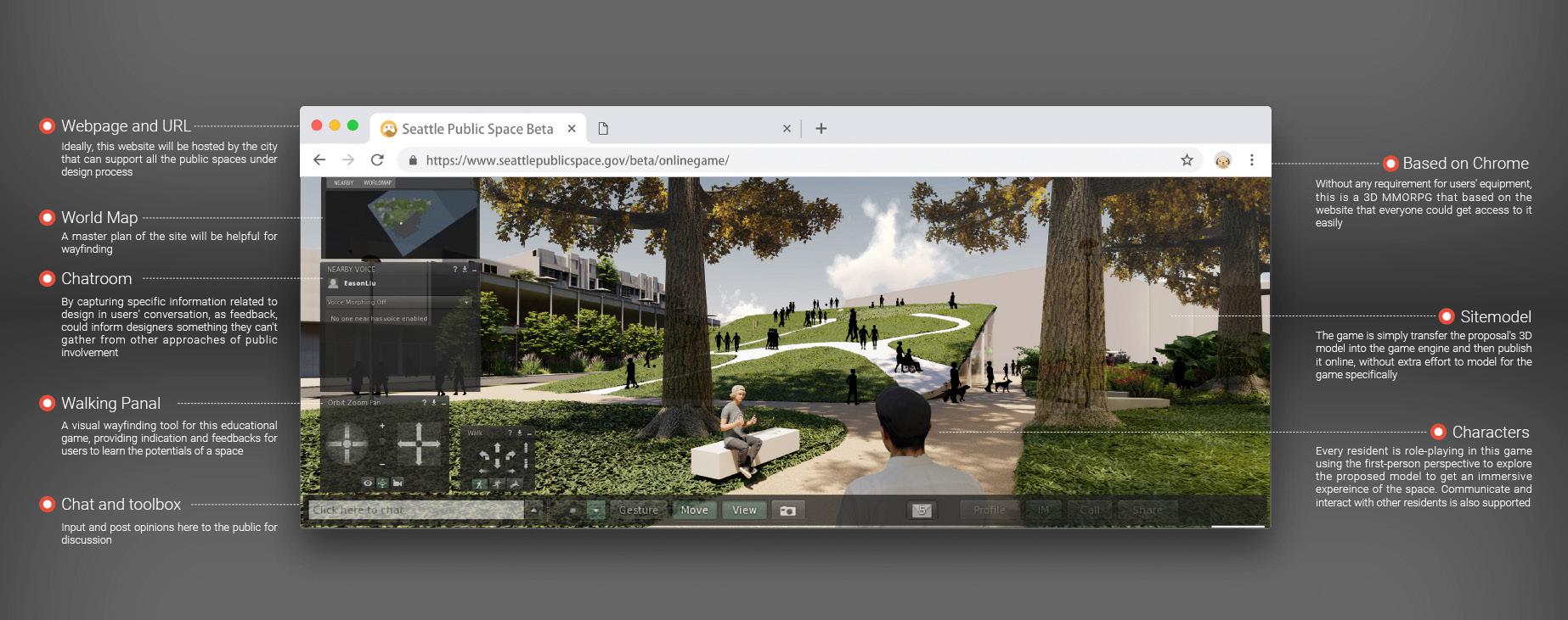
The game elements are building blocks of a game, but there is no architect starting with selecting brick when design a building. At the very beginning, we should be clear about how do we want the users to feel and what is the goal for their intended experience? Inspired? Proud? Anxious? After that we can start selecting appropriate game elements that can accomplish the goals to ensure users feel this way. Below (figure 3-11) is a potencial scenario game interface design for a including a world map and walking panel to track player’s in-game footprint and help designers to project where are the hot spots on this site. Also, the chatroom is offered to engage more free discussion on the design whatever it’s about the good or bad side of the plan.
3.2.3. Case analysis: gamification applied in PLD
Phase: Pre-design
Size: neighborhood
Type: public project
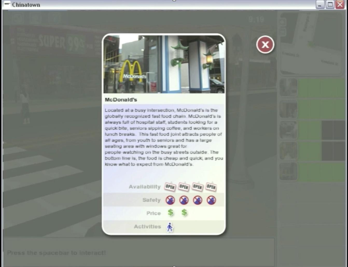
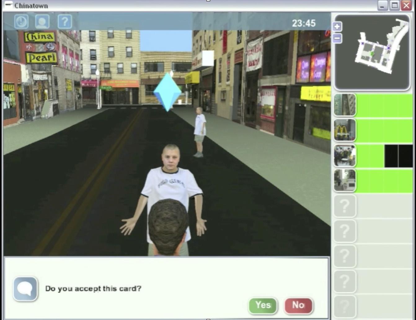
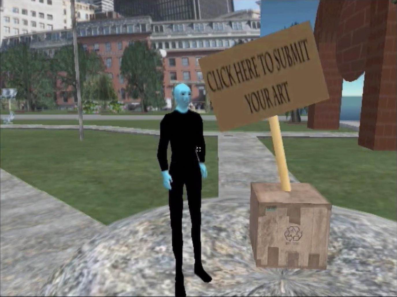
Case: Participatory Chinatown.
In this project, the engagement lab employed gamification tool in Second Life, to encourage players to explore the Boston Chinatown which is built in this game. There are a lot of choices of characters to role-play, player need to interact with NPC
(See Figure 3-13) in game and switch collected object (See Figure 3-12) for passing the game. This case is designed with more mechanics that makes it look more like a game instead of a participating tool. At the end of the game, the leaderboard will show how other participants performance, and players will be motivated to spend more time in the game to compete with others. The longer they stay at the game world or achieve more tasks, they will feel more familiar with the site.
Successes:
This project embeds Points-Badges-Leaderboards mechanics to motivate the user to engage more in this participation process, which is also being widely used in other industries like the product design profession.
Limitations:
This project may invest most of the time on modeling the whole area of the site, which will be a time-consuming task, which is not cost-effective for most of the practitioners to spend the efforts to do so. However, with the iterating of technology and people being exposed to technology more, this situation will no longer be an issue in the future.
Phase: Early phase of design
Size: neighborhood
Type: public project
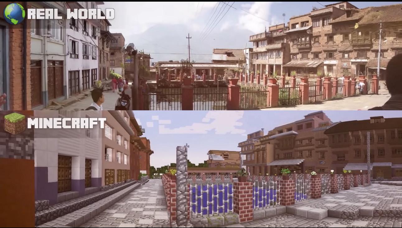
Case: Block by Block. (See Figure 3-14 and 3-15)
The Block by Block project is the work of UN-Habitat –the United Nations agency for sustainable urban development–together with the makers of the hugely popular world-building computer game Minecraft.1
This organizers want to employ this game platform, to understand local residents’ preference and imagination of their living environment through observing their in-game performance.2 To achieve this goal through public outreach, the project split into two steps: the first step is to help local residents have a better understanding of the site from each others perspective. This leads to a massive multiplayer build game to build the neighborhood spaces collaboratively based on Minecraft to gamify this process, which will be beneficial to share everyone’s view of the site. The second step is to find out the problem as well as inspiration from the participants, as designers need to observe participants’ in-game behavior: what they built and how they built them, to get some insight into what local residents see the site.
Successes:
This case achieved a great sense of participation as everyone is contributing not in words but in a visualized way, which would be more helpful for designers to capture participants idea. Because in most of the time, non-professionals have a hard time to describe their thoughts towards design in an efficient and precise way.
Limitations:
However, it also revealed some negative sides of gamification in PLD: it may raise participants’ expectation as the realistic 3D visualization, and sometimes they found imagination might be limited by realistic visualization as the built world looks like a ‘final’ outcome instead of a proposal for further discussion.3
Figure
Figure 3-13
Figure 3-14
Figure 3-15
Phase: Early phase of design
Size: neighborhood
Type: public project
Case: @stake. (See Figure 3-16)
Game for Participatory design is not necessarily to be realistic or first-person’s perspective, this text based mobile game is designed to role-playing people of different profession and chatting with friend as their own character, in order to build empathy for others. @stake is an online multiplayer role-playing game that by gathering input from residents, especiallty social context, to foster creativity and empathy in small group communication. This mobile device-based game is transferred from table-top card game that fosters democracy, empathy, and creative problem solving for civic issues. Players take on a variety of roles and pitch ideas under a time pressure, competing to produce the best idea in the eyes of the table’s “Decider.”1
Successes:
Text-Based game is a way to simulate face-to-face communication but cost less for both designer and participants. For designers, there’s no modeling and rendering work required thus saved the time; for participants, with the virtual chatting room, they can still feel a sense of being involved without being in the meeting physically.
Limitations:
Text-Based game may only be applied to the early phase of design without an actual proposal as the text-based format may be a limitation in legibly informing design proposal.
Goals How to achieve Game elements applied
Capture concerns from conversation Having people play at the same time and start a conversation
Know about what concerns different people have Have people speak from different people’s view
Phase: Mid-phase of design
Size: Plaza/square
Type: public project
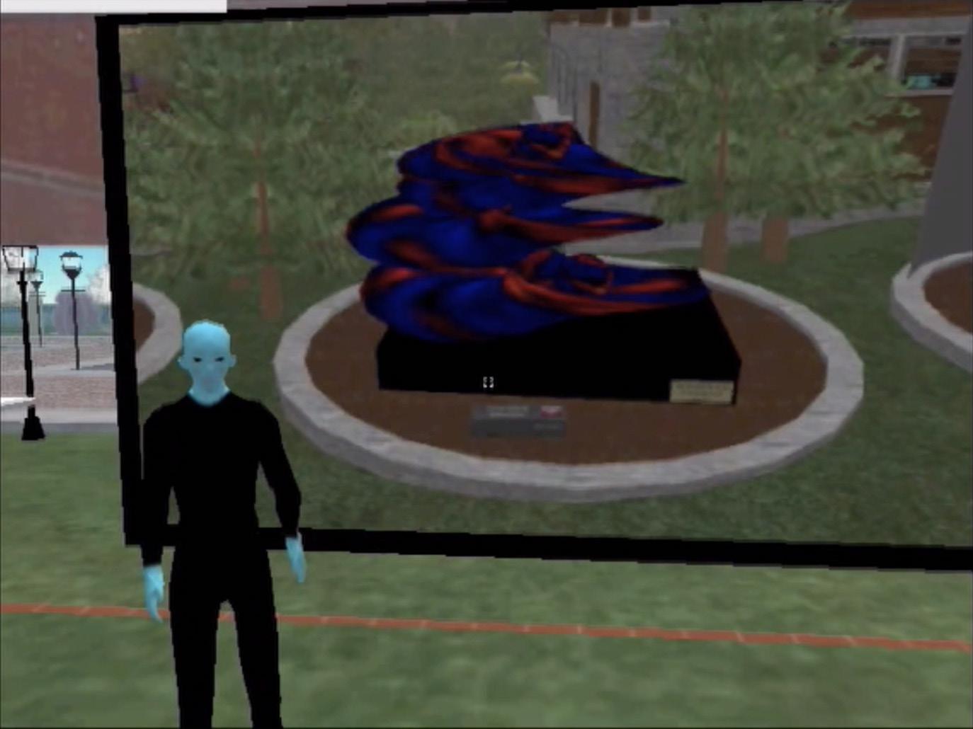
Case: Re-imagine Boston city hall using Second life
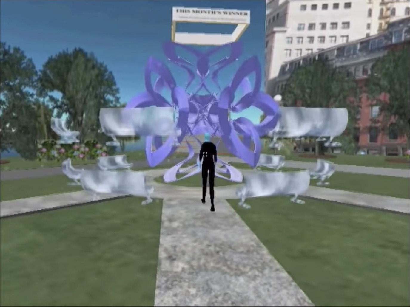
Hub21 was a pilot project which is conducted by city of Boston, they came up with several alternatives of re-imagine the city hall. Through the use of Second Life -a massive multiplayer online role-play game, to engage participants and encourage them to vote for their preferred proposal. For example, in figure 3-17, the NPC is introducing each alternative proposal and invites players to vote for their favorite work. In figure 3-18, the NPC is introducing the winner on the leaderboard in a period basis, which can be an incentive for participants to share proposals. And the winner’s proposal will be displayed in a 3-dimensional way for players to explore and experience comprehensively as figure 3-19 shows.
Successes:
Besides of voting and exploration is allowed and applied to achieve the goal of outreaching, players can have communication through in-game chatroom. This case brings about a potential way to incentive the audience to give more feedbacks than just listen to the presentation.
1 (city of Boston n.d.)
Figure 3-16
Figure 3-17
Figure 3-18
Figure 3-19
3.2.4. Targeting the group and information component
Because of the complexity of PLD, it is impossible to write a comprehensive, cookbook-like instruction for how to use, use which game elements and how to arrange them in detail project by project. As a result, the purpose of this guide is to provide a catalog of mechanics with several examples listed, in order to enlighten a way of thinking through each project’s specific situation.
As the challenge is to be clear about which techniques are most appropriate in each situation, there are some questions shows in figure 3-20 that may help plan the approach in a logical manner:1
Criteria Logistics behind
How will the decision will be made?
What goal do you hope to accomplish with the public?
What does the public need to know to participate effectively?
Who is the public for this project? Which part of the public must reach?
What questions need to be answered by the future users? What to expect about their feedbacks?
Are public’s opinions dominant in this participation?
What kind of feedback we need? Detailed or general.
Give them a common ground in advance and clarify the limitation of the participation
Who are the main users of this project
Translate any open-ended question into choicebased question, offer a clear direction for participants.
What public involvement techniques best meet these requirements? which mechanic could help guide people to understand the question?
How to collect and organize the feedbacks effectively? Selection of format of survey questions1
Note: Besides those principles discussed above, some special circumstances which could affect selection of techniques may also need to be considered:
1) program that acts successful in one situation may not effective in the other; 2)or some techniques used may have influence back on the situation, and then we have to rethink the selection of techniques.
The ‘selection of format of survey questions’ refers to the way to embed feedback collecting system in the participation process. For example, when designers know clearly about what specific questions are and what feedbacks they are looking for, choice-based interaction would be a great choice that can help participants make quick decisions without feeling fatigued as filling out open-end questionnaires.
3.2.5. Conclusion
As new opportunities are being afforded by immersive visualization applications for enhancing public participation in public space design, there will be a mutual benefit for all stakeholders, including landscape designers, residents, and governments, and thus achieve a good relationship and satisfaction among all parts.1
Design expression serves as a mediator between people and the environment they designed. Designers who created the presentation with their own biases, which affect what they present, may influence the user’s expectation of the outcome. In a interactive phenomenon, this bias could be eliminated creating direct relationships between the virtual and physical world, and thus this interactivity can bring about communication and agreement. 2 This communication will ultimately help build a sense of participation, thus populate the urban public space could help lift a region’s reputation, activate economy, and bring in more population, which will end up with a virtuous cycle.
For landscape designer, the use of interactive design tool can help expand the relationship between landscape architecture and virtual placemaking, like video game environmental design, for creating a human-centered interactive experience in the future design horizon.3 This sometimes may save in the cost of developing with a comprehensive model. The only thing we need to work with is put it into a game engine (Unity; UE4) and add the mechanics according to the project’s feature and questions that best interpret the designer’s concern. However, it is well worth addressing some of the pitfalls in this study such as the time required to understand the program. For my own experience, at the very beginning, I was not able to code or write scripts for some specific experience or interactions that required in Unity, which requires time to learn. was trying to develop a prototype with all potential applied elements and scripts set up as a plug-in using Unity. However, this prototype was ultimately aborted due to the time issue and technical difficulty.
1 (Walz, et al. 2008)
2 (Cantrell, Virtual Reality in Landscape Architecture 2019)
3 (Ong 2018)
1 (Public participation n.d.)
Figure 3-20
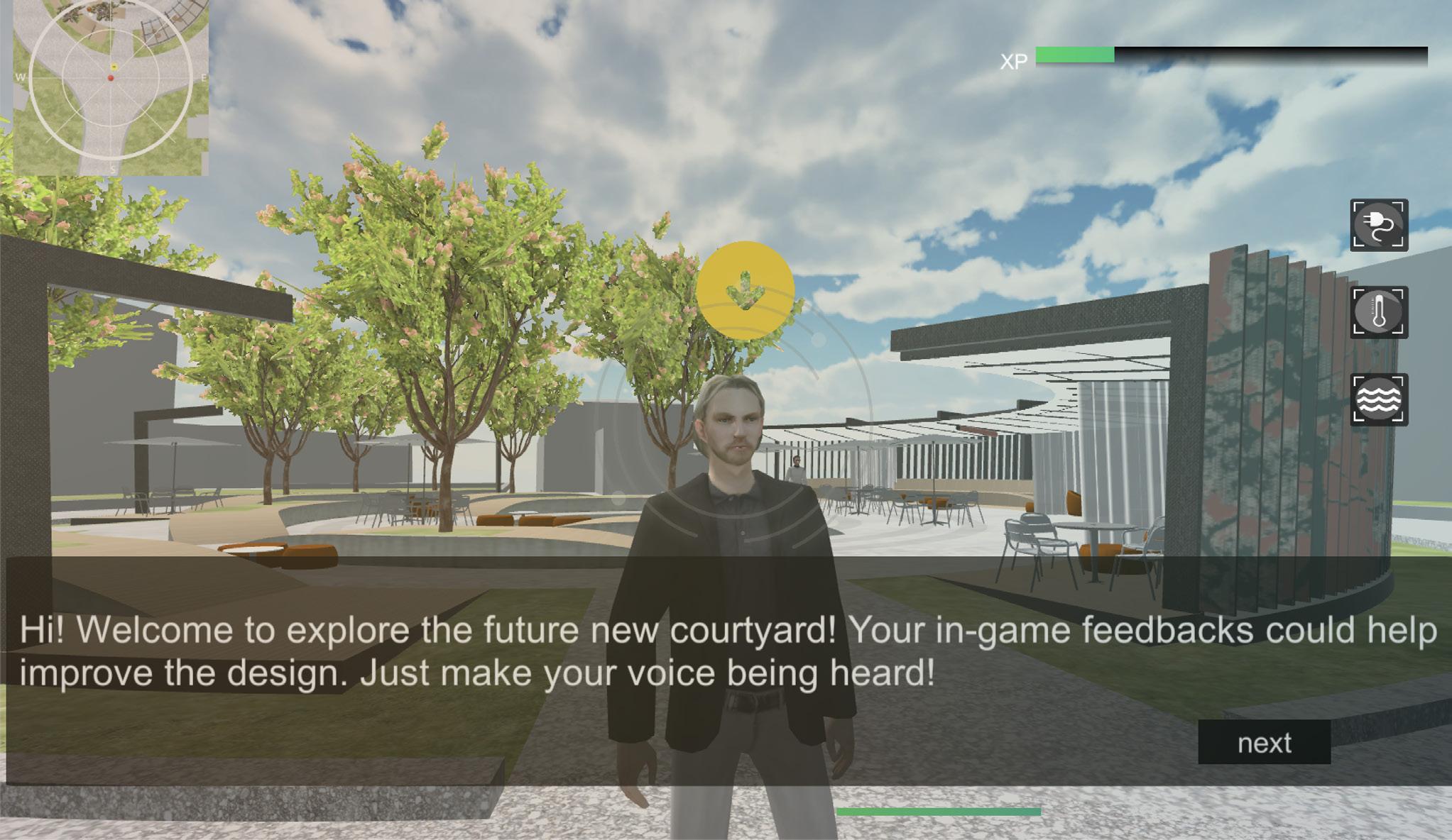
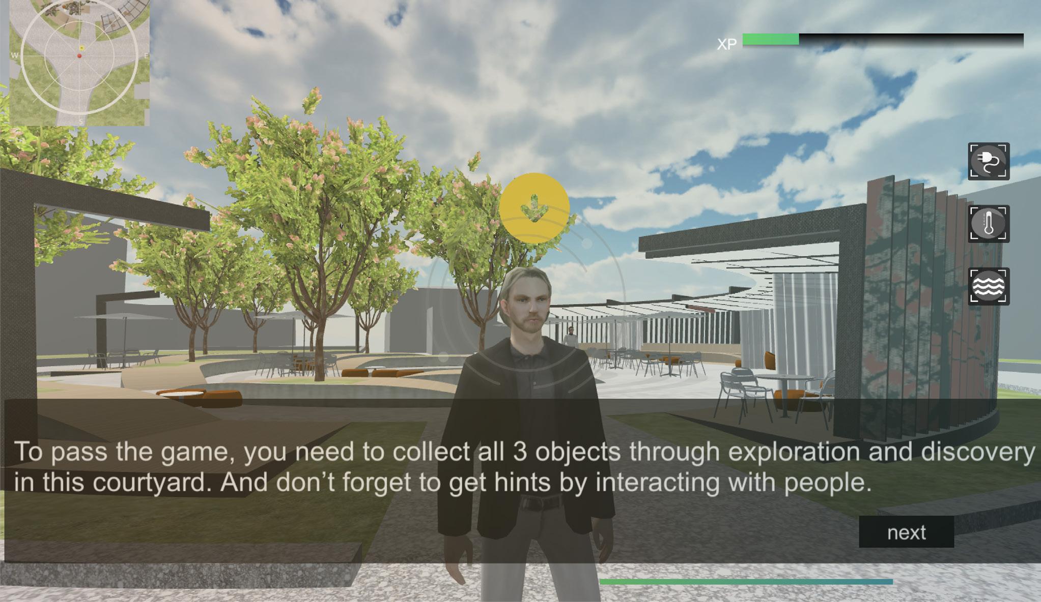
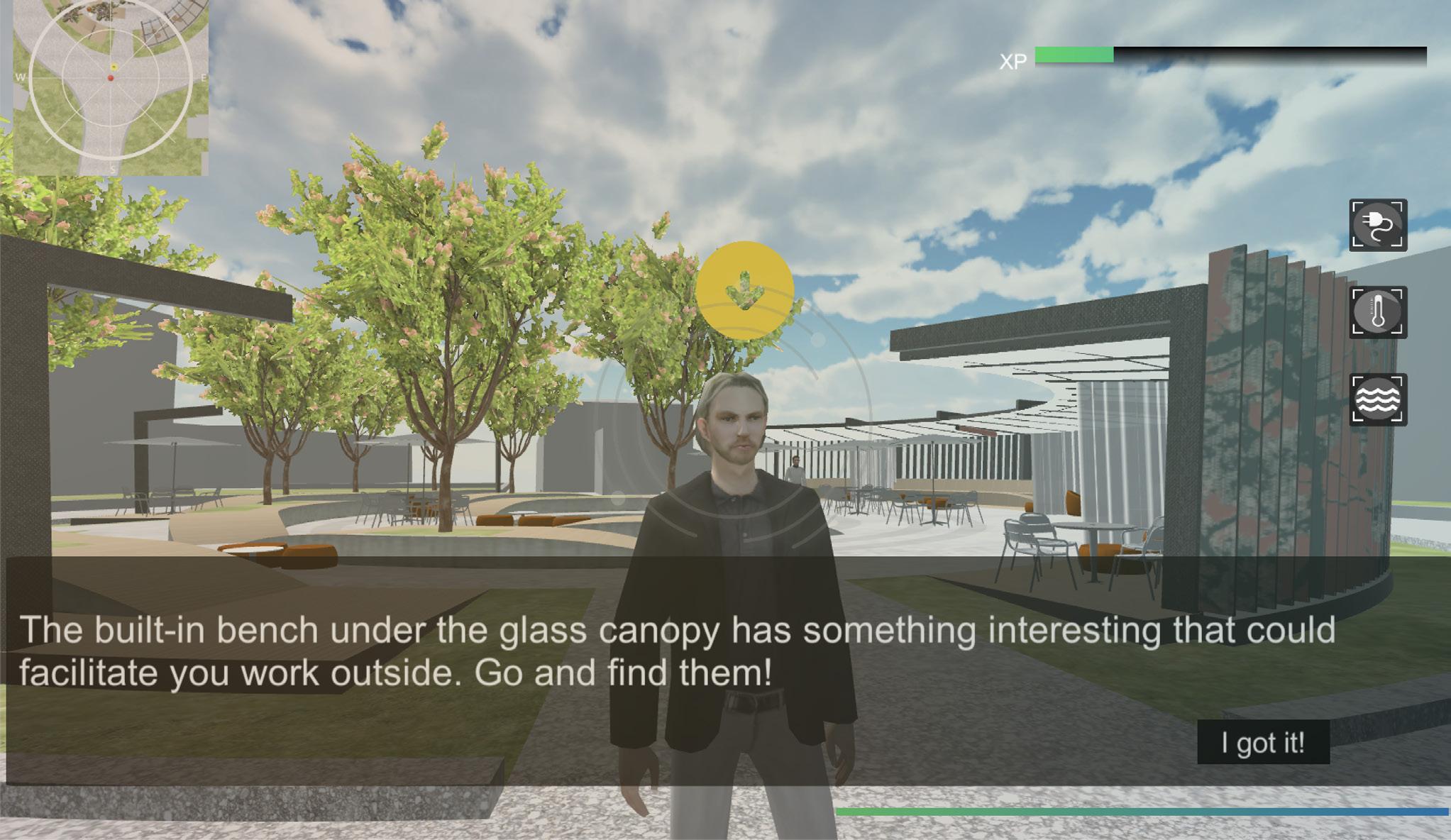
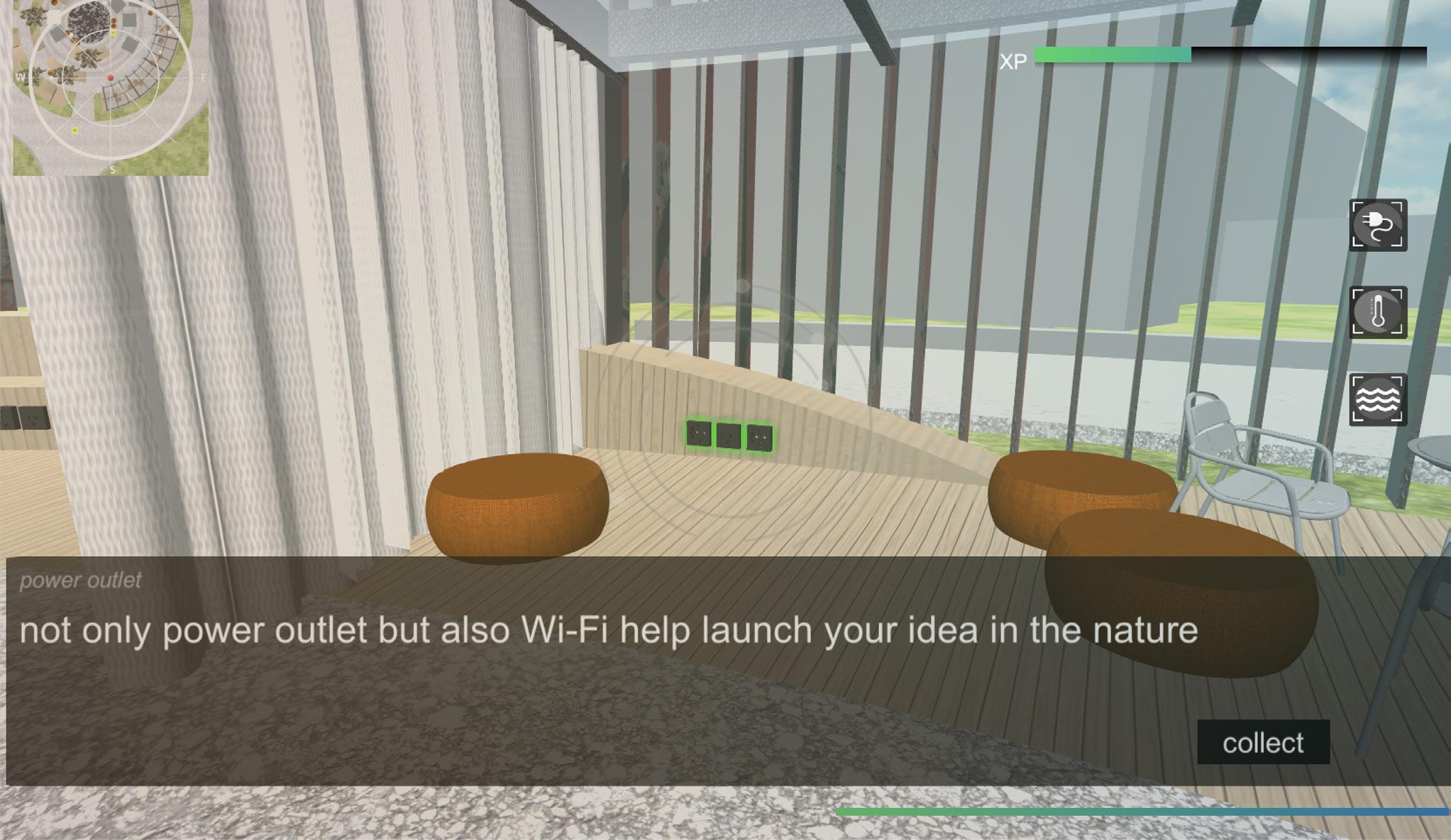
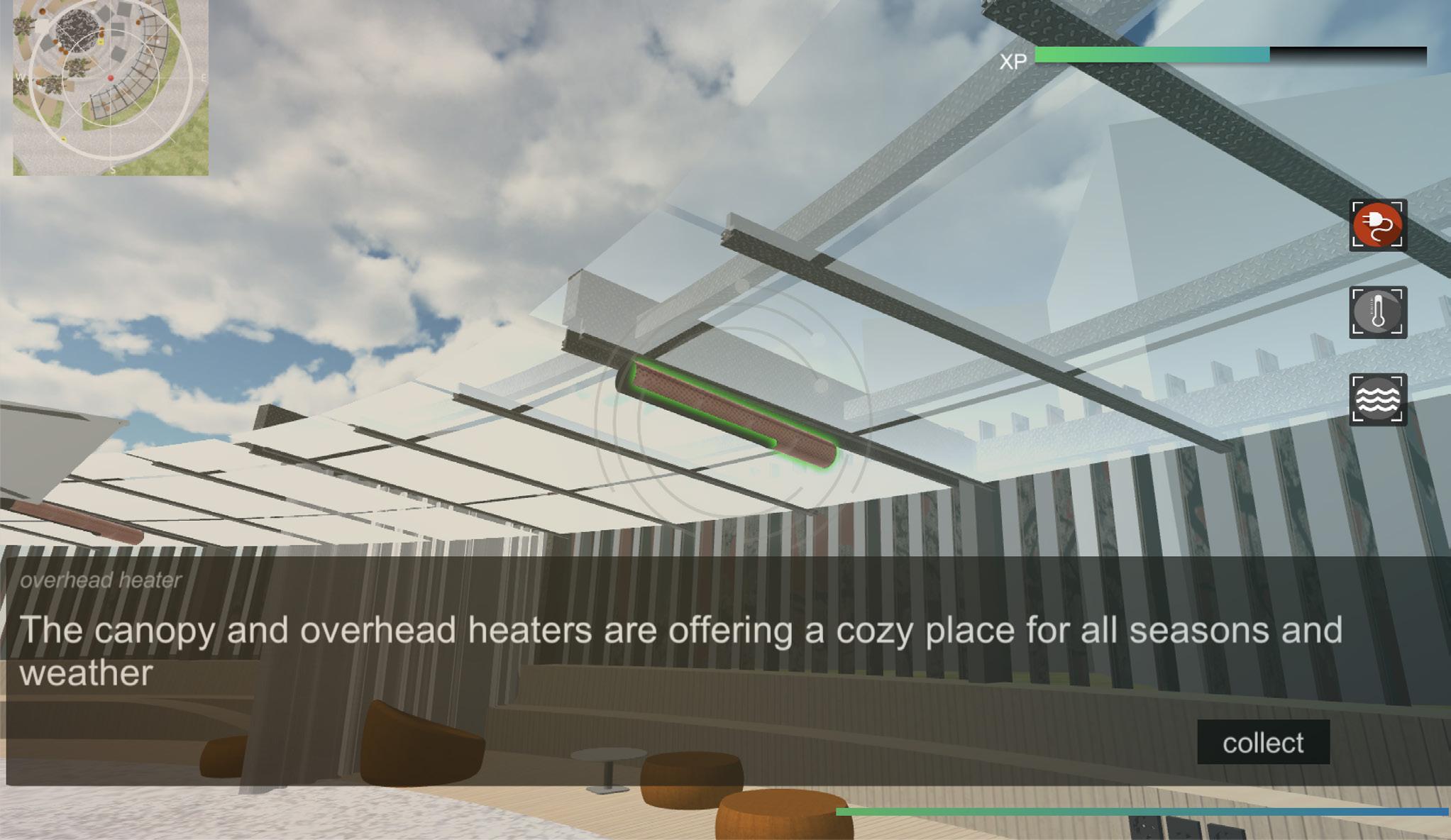
CHAPTER 4
2.2. Recent approaches of PLD embedding technologies
EXAMINATION AND APPLICATION
PILOT PROJECT
4.1.。 Set up module and research methods
This section serves as an example of an elaborate explanation of how to apply the game elements in a real project explicitly as an extension of chapter 3.
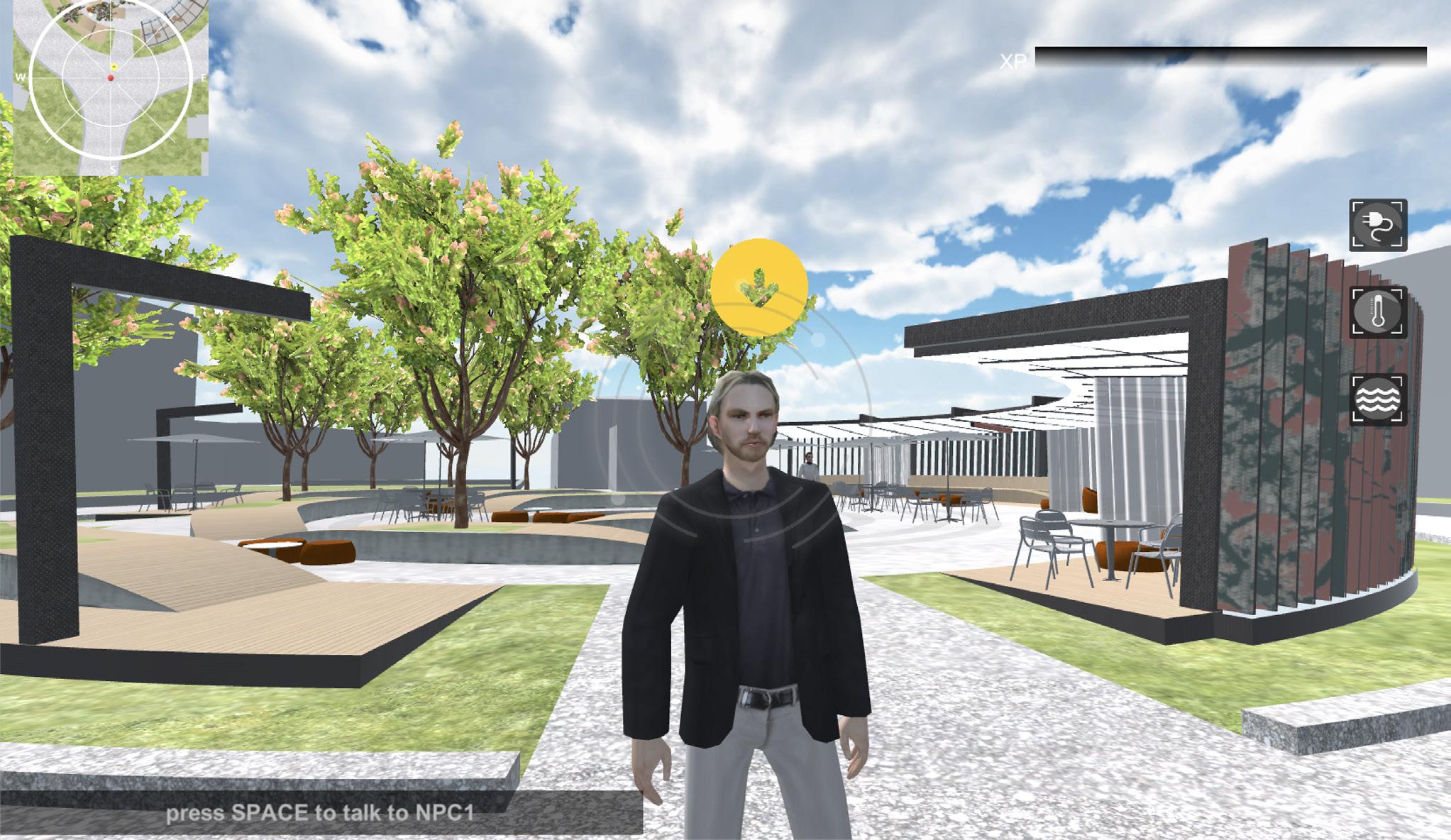
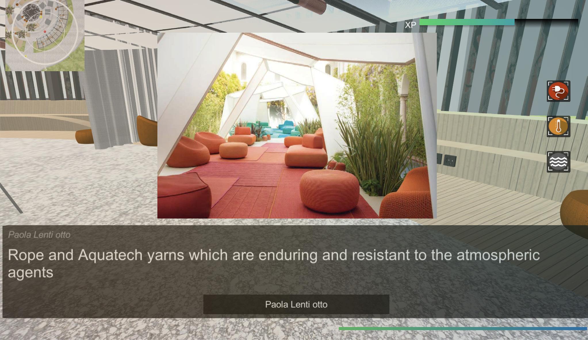
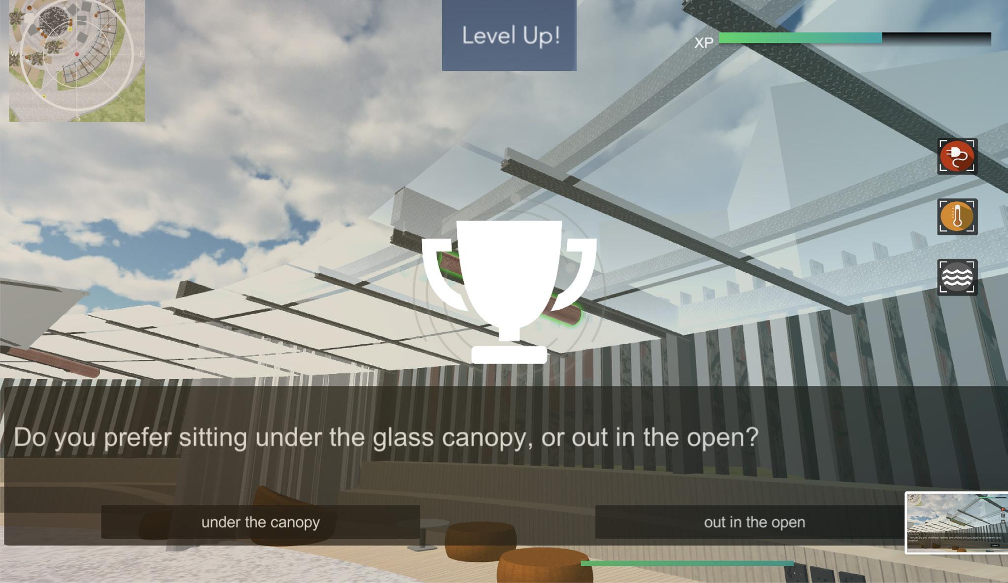
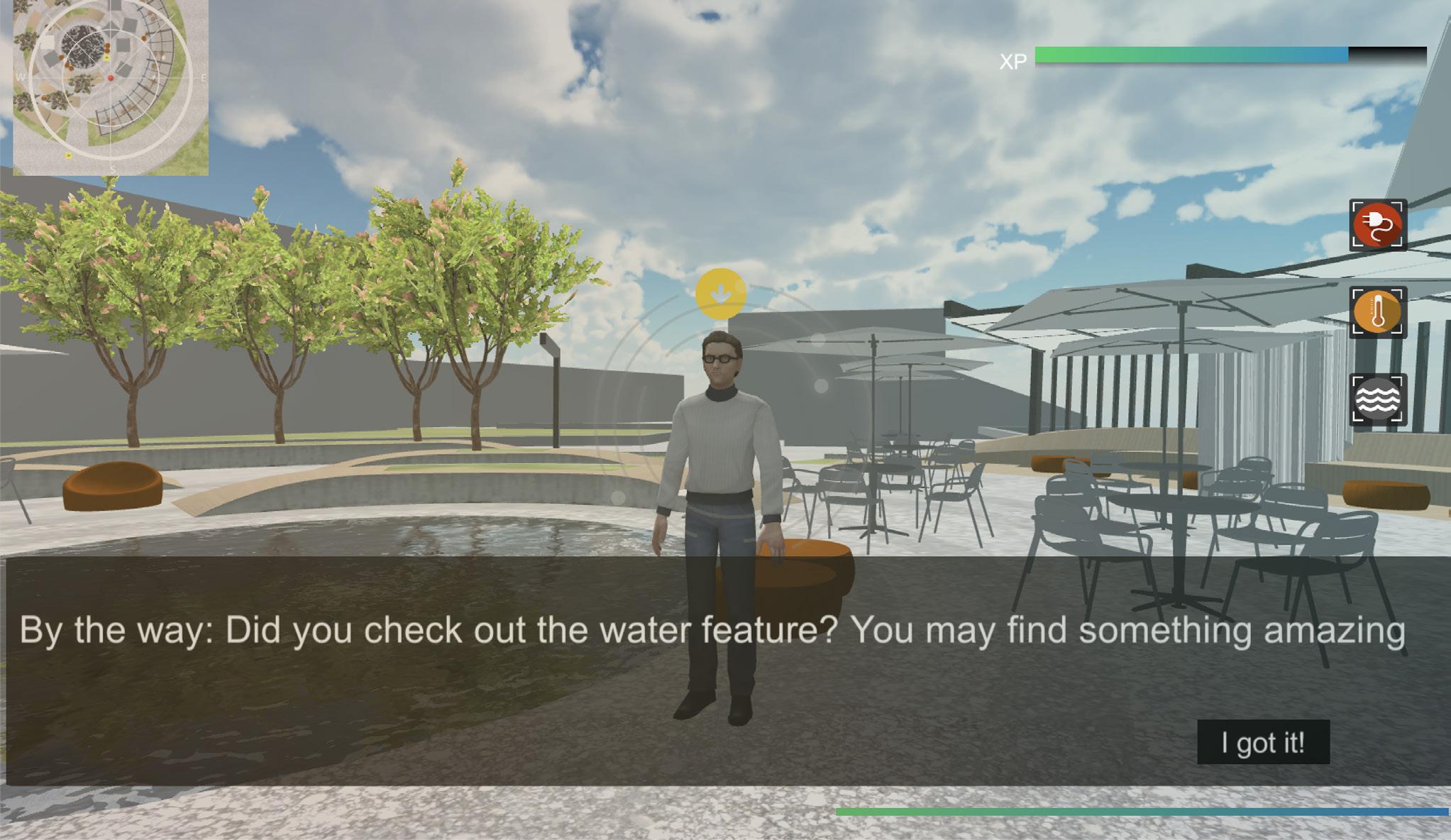
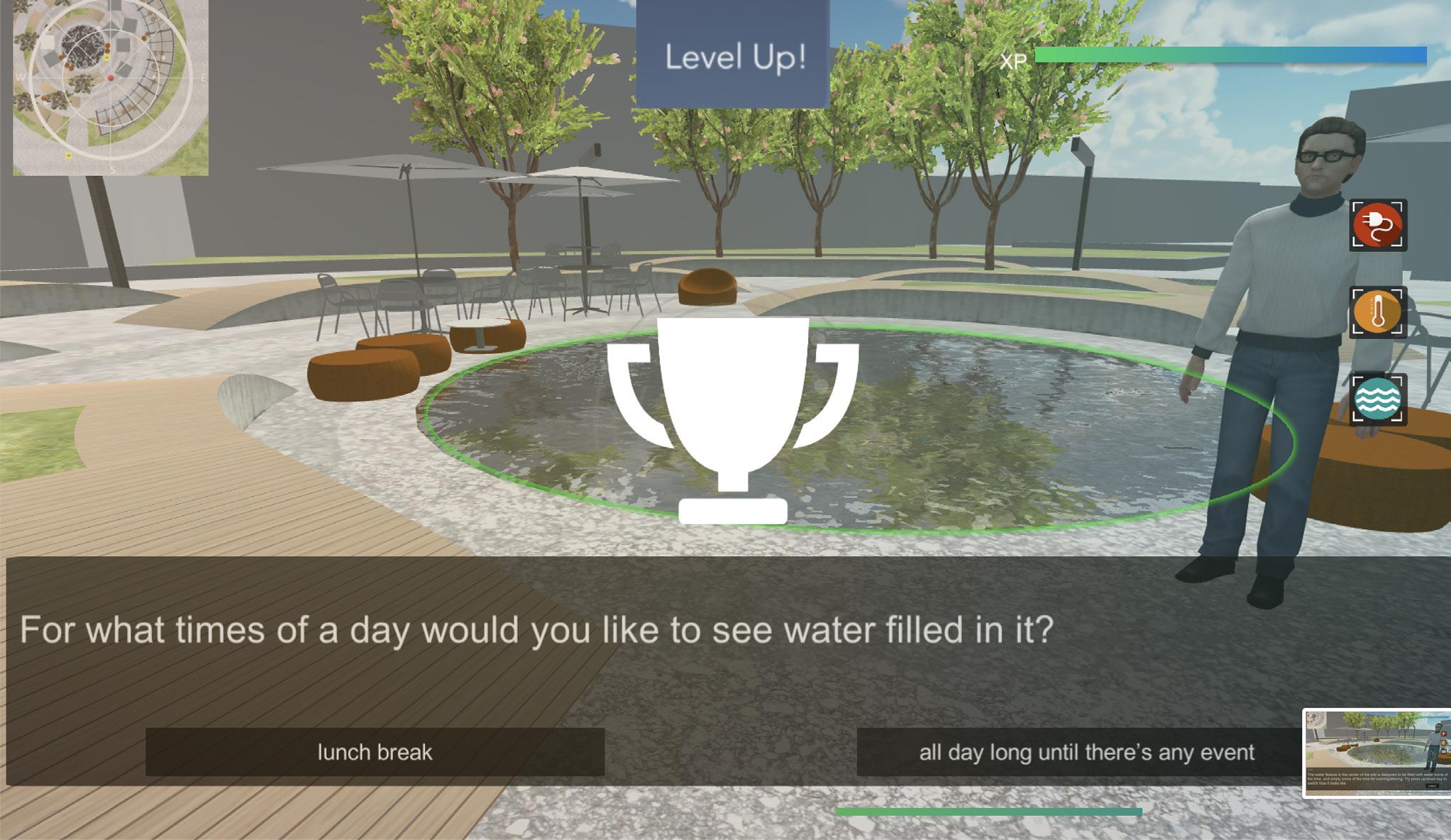
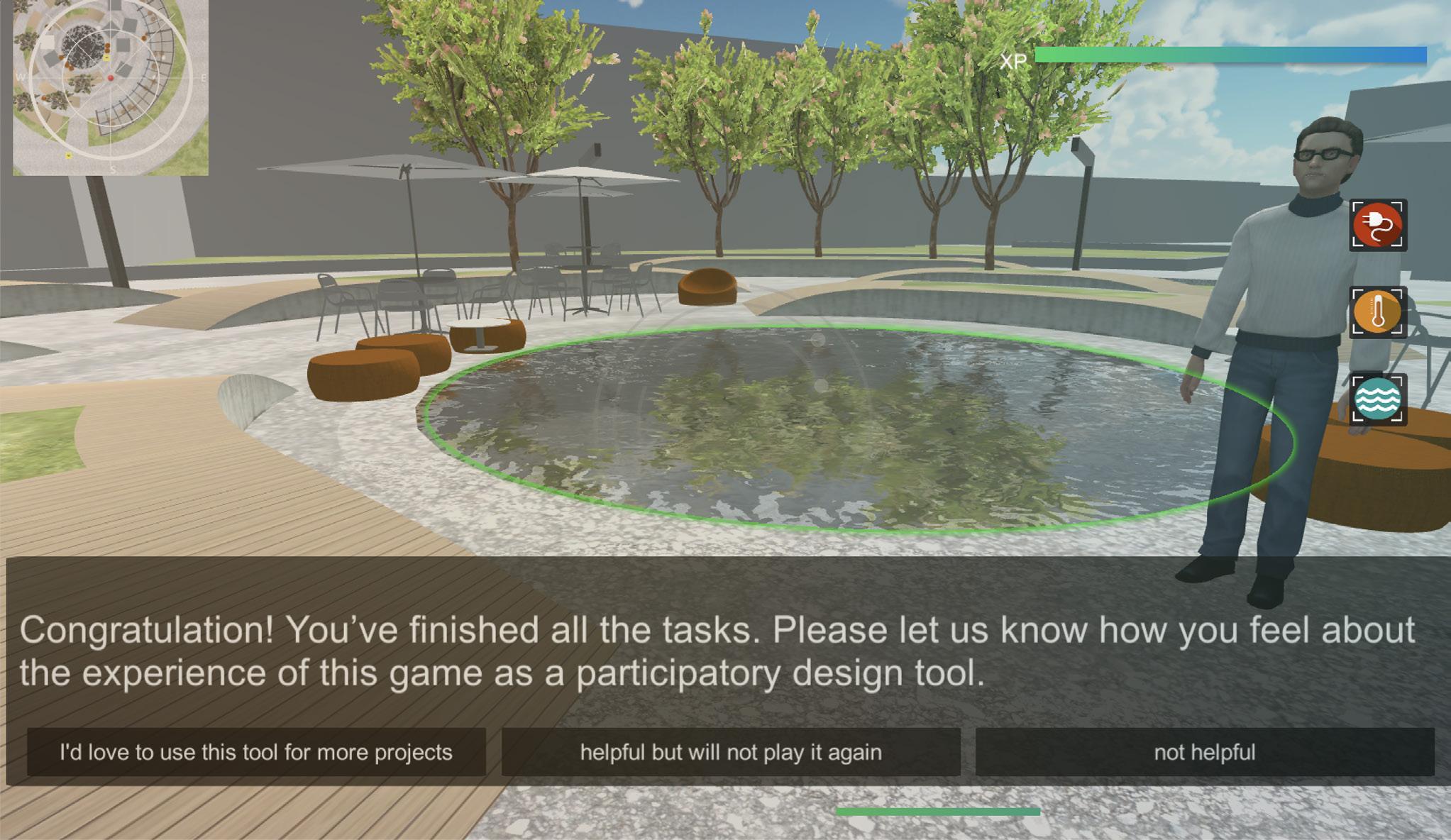
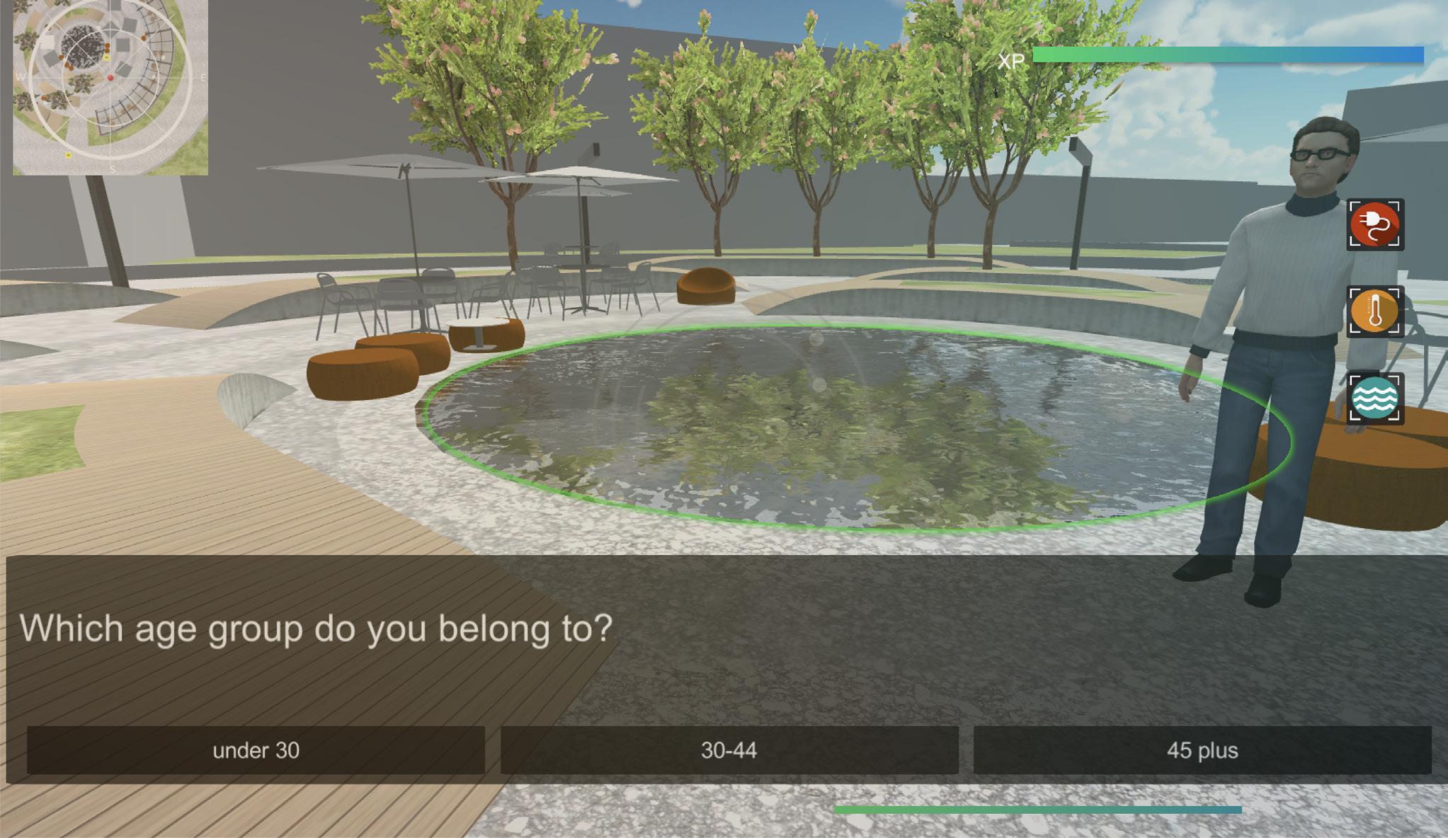
The game aims to offer an example of how to start from figuring out the goal of PLD session, translating survey questions in gamification approach, and lastly choosing and applying several game elements from the matrix into a game engine based on the project’s 3D model and make it game-like experience participation. In this project, the most crucial goal is to inform the player with the features and concerns of a proposal and ask for feedback. When the player finished the game, answers would automatically be collected in the back-end like the screenshot (figure 4-1) shows below, which will be gathered to help designers with further decision making.
4-1
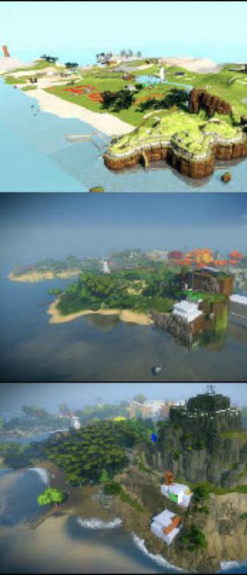
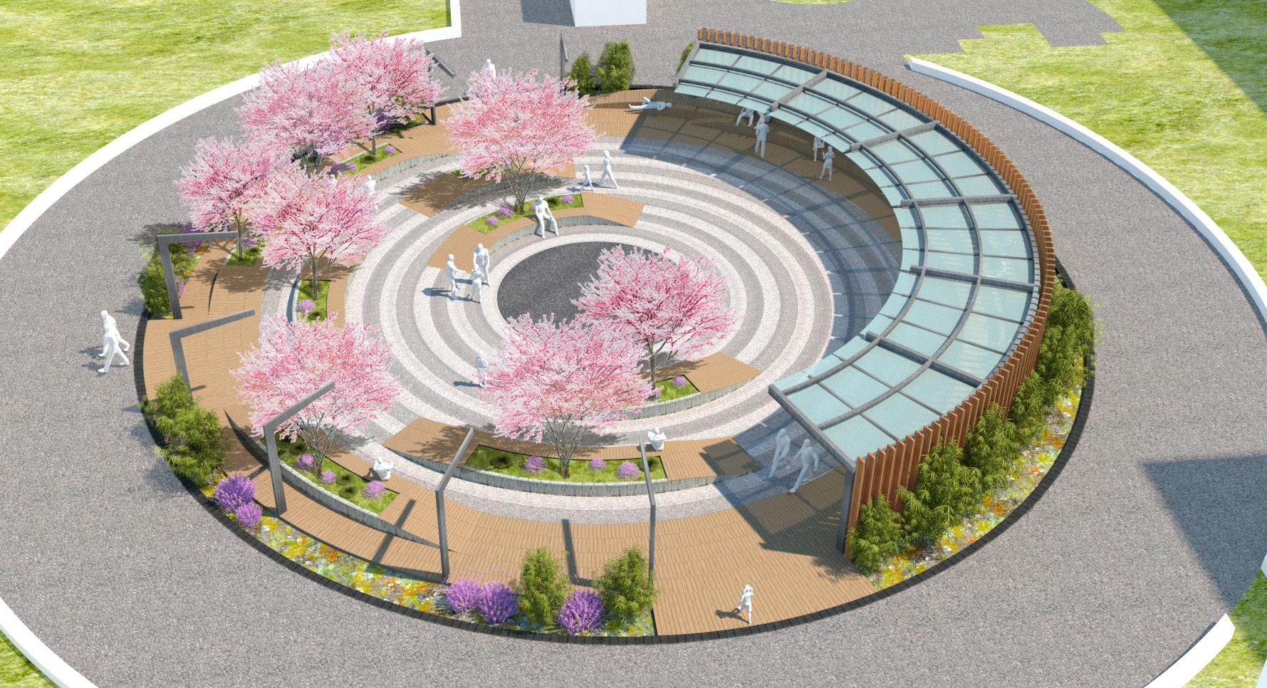
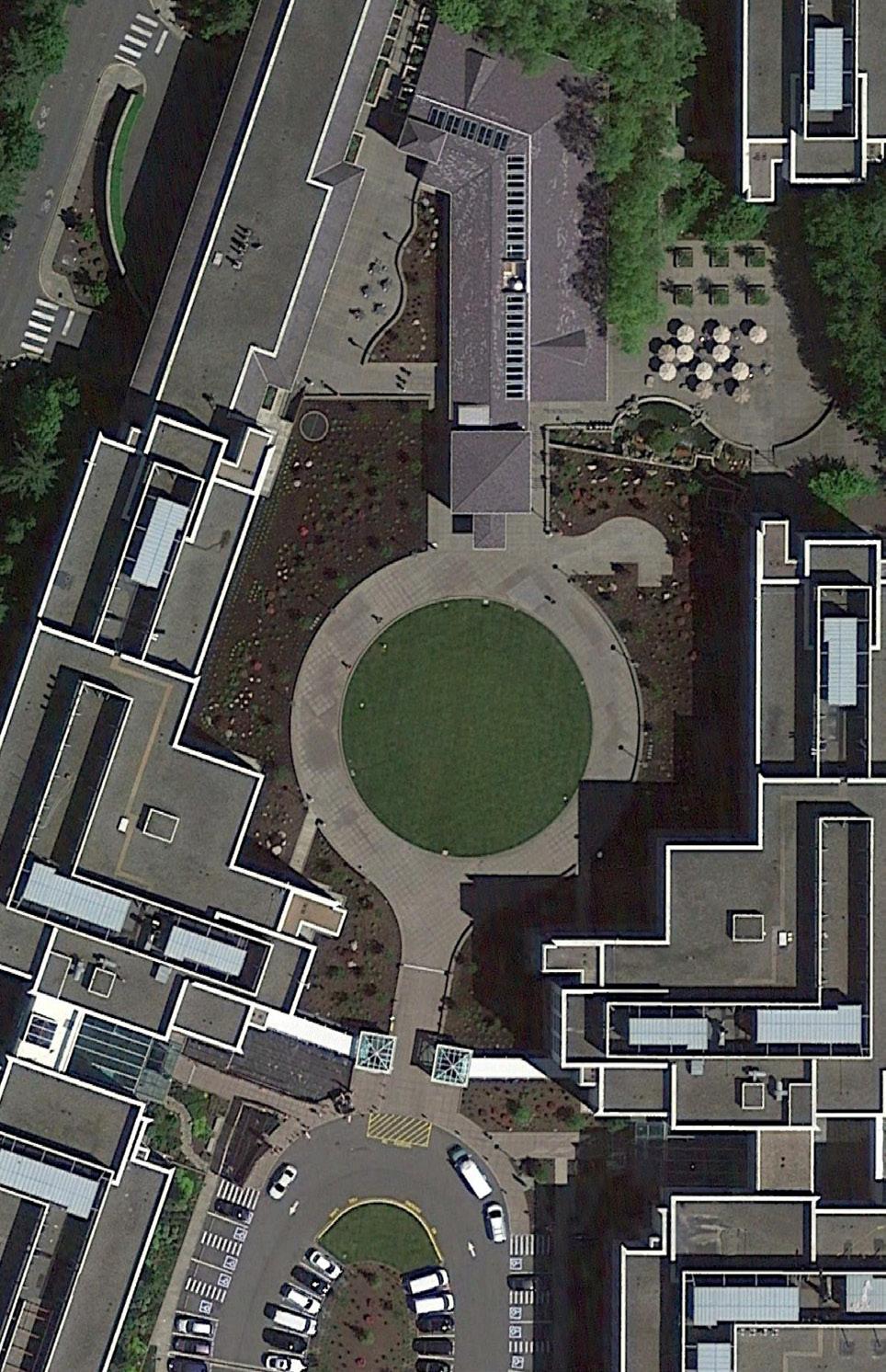
4.1.1. Project overview
Phase: Late phase of design
Size: courtyard scale (see figure 4-2 and 4-3)
Type: Private owned public space in an office campus
The pilot project is a courtyard in a tech company campus in Redmond, WA, which I participated in the design during my internship at PLACE studio in summer 2018. Since this is a privately owned project, there is no participatory design process in advance. Plus, as this is an office campus, the company does not want to spend time organizing meetings on the campus design decision making. Currently, this project is in a later phase of the design stage, and probably not much freedom for making changes though, this game-like experience of participation tool may help employee, the future user, to express their need and preference. However, as the pilot project now is on hold and we have no ability to test this game with current employees of the office campus to participate, this study now is based on the feedbacks from experts from both professional and academia.
Figure
Figure 4-2
Figure 4-3
、4.1.2.Conduct survey and Designers concerns
1: The water feature in the center of the site is designed to be filled with water some of the time, and empty/dry some of the time. During the course of the workday, how long would people like it to be filled with water, or what times of day should it be filled (for example, would people like to see water in it during their lunch breaks)?
2: In the design, we have a variety of different built-in wood benches, some of which have backs, some of which have no back support, and some of which have foot-rests that let you recline or lie down. What kind of bench are people most comfortable sitting on? Do people prefer to have back support? Do people feel comfortable reclining or lying down in a work environment?
3: Will employees use the space to work, or will they just use it as a space to eat lunch or take a break from work? This isn’t shown in the model, but please note that the design has outlets built in to the benches so people can plug in phones, laptops, or tablets if they wanted to work outside.
4: Do people prefer sitting under cover (under the glass canopy), or out in the open? If it’s raining, will people feel comfortable sitting outside under the canopy? Again, these aren’t shown in the model, but there will be overhead heaters attached to the canopy for people’s comfort.
4.1.3. Choose appropriate game mechanics from the catalogue
Help participants better understand the space In a realistic way of display and view
Know about if employees use the outdoor space to work Inform users the amenities for supporting work outdoor Exploration and collection
Know about if people prefer sitting under the glass canopy Inform users the amenities under the canopy Exploration and collection
Know about when do users like water filled in water feature Show the change Interaction
Need their feedback Embed choice task to make participants answer Choice/ rewards/ time Figure 4-4
4.2. Game design
4.2.1. Game Level Design Quick sheet
Big idea This game is a first-person exploration game dynamic with a collection of clues, which are a set of design features that wish the user to be informed and give feedback on. The game is talking about an employee based on the context of the on-going tech company project.
Genre: This game draws elements from the exploration, puzzle and collection games
Category: In video games, first-person is any graphical perspective rendered from the viewpoint of the player’s character. This game is a unique experience that seeks to combine the first-person adventure game, like Far Cry, and a built environment visualization tool, like CBRE Build, for the future users.
Platform: Web browser
Licenses: Design firm: PLACE Studio; Client/Property management company: CBRE
Play mechanics: Players will control the player character using a first-person perspective as he/she moves through various locations within the site that comprise the game world. Key components of the gameplay are exploration and interaction with NPCs. The player will use keyboard and mouse inputs for the controls, as well as conventional FPS or RPG mechanics such as acquiring items, leveling up and initiating dialogue encounters. Key in-game screens to support these play mechanics or game user interface (GUI) include:
Screens description
Main gameplay screen
The primary screen with several distinct sections, including the MiniMap with compass for way finding, progress bar, quests status bar and action instructing bar.
MiniMap I set up one window for me actually walking through the site at eye level, but then also a second window to see you know where I was.
Dialogue box Popup when interact with NPC and objects on site, including information of the objects, quests, answering questions and hints for quests.
Pop-up box Popup when leveling up, wining, and special events.
Technology: This game is built with Unity 3D, a robust game engine for making indie game for different platforms. The toolset helps organize all the elements that constructing a game, includes script editor (language -C#), asset organizer, canvas for dialog boxes and other 2D elements, conversation editor, objects/models palettes, material editor and animation effects. And the host website if Firebase, which supports large file like a game and collecting data from users in-game behavior.
Target audience: This game is for engaging the employees working in the office buildings surrounding the project site. Their in-game answer and feedback will be collected, counted, and served as a reference for later design decision-making.
Characters:
Character Description
The player
Character Player control the player character using a first-person perspective
NPC1 the first non-player character that player will interact with at the very beginning of the game. Introducing the overall game goal and offering hints for the first part of quests.
NPC2 the second non-player character that player will interact with after finishing the first part of quests. Offering clues for the second part the quests.
Game Prototype: https://molilarch.itch.io/public-space-beta
Game shot 1: the game starts with facing the first NPC who is standing in the entrance of the courtyard (can be seen in the MIniMap viewport) in order to be significant to interact with.
Game shot 2: The first conversation will be informing the player about the background and brief introduction of intention.
Game shot 3: The NPC 1 continues with a introduction of the requirement to pass the game.
Game shot 4: The NPC 1 will finally end up the conversation/interaction with the player with a hint that the player needs to take action for the next step. After the full interaction with the NPC 1, the player will be leveled up.
Game shot 5: When checking out the built-in bench under the canopy as suggested by NPC 1, players will find and interact with objects that have green illuminate-outline when swiped with the cursor.
Game shot 6: Players will be asked about a survey question in regarding of the amenities that are informed just now. All the questions are choice-based, which can ensure the efficiency of playing. After the player accomplished collecting each design feature (usually are amenities offered in the proposal) successfully, an icon on the right side will be ignited.
Game shot 7: Players are supposed to explore the whole site and find out all the amenities or design features, to collect and ignite all the icons successfully to pass the game.
Game shot 8: After each design feature is collected, a survey question will follow up.
Game shot 9: Some of the design feature or amenity just simply informing players with the materials and function, like the poufs, instead of collecting feedback.
Game shot 10: After collecting all the icons under the canopy and the player may lose direction, talking with another NPC will always get helped with a hint.
Based on the suggestion, players could see design alternatives to understand better and compare design proposals. Here, players can switch the water feature to see how it looks like in different situations.
When achieved all the tasks and answered questions, players will pass the game and can keep on answer some additional questions. This survey has nothing to do with design but about this gaming format as a participatory design tool.
Game shot 11:
Game shot 12: Also followed with a survey question after finish collecting new design feature.
Game shot 13:
Game shot 14: designed this question to investigate the acceptance of this tool related to age group.
4-5
As shown in figure 4-5, a list of the in-game answer will be collected after each player finished all the survey question and successfully passed the game. The responses will be collected as design feedback in a database, and will serve as a reference for future design decision making.
4.3.Feedback and reflection
4.3.1. Feedback from experts and professionals
Through inviting experts from both professional and academia to play the game, talking about the initial questions of this study, and asking them questions which are listed below, we were able to learn if this tool could be used in the future based on six aspects classified by perspectives from both users and designers responding to the evaluation in the Chapter 2. These include immersion, participation, operability, and convenience. Below are interviewee information sheet and question-answers sheet.
Name of Interviewee Profession Place of work/ study
Molly Cooney-Mesker Urban Planer MIG
Brice Maryman Landscape Designer MIG
Dave Rodgers Civil Engineer MIG
Feifei Deng Human-centered Designer Communita| Atelier
Phoebe Bogert Landscape Designer PLACE studio
Sarah Canepa Landscape Designer PLACE studio
Katherine Goodrich Landscape Designer PLACE studio
Milenko Matanovic Community Builder Pomegranate
Mackenzie Waller Landscape Designer Framework Cultural Placemaking
Pearson Lawrence Game designer Academy of interactive entertainment
Yizheng Liao Real estate marketing analyst Zillow
Nuozhou Fu Urban data analyst Waverley Council, Australia
Yuan Li MLA student University of Toronto
Wanyi Li MLA student UVa
Questions asked Good side Need improvement Reflections
Operability:
Time spent on figuring out how to play
Operability:
Comfortable with playing?
Participation:
Still remember the objects collected after passing the game?
Immersion:
Visualization issue?
Cost of developing:
How much effort willing to put in develop this?
Manageability:
How to tell if a participation process is successful or not?
Participation:
Does it help in PLD?
Right away More than 15min
Can be really easy for some of the people
The interface need to be improved
Can be a handicap for certain groups of people especially people with disability
Nothing to do with age group but with previous gaming experience
May not notice in other way
Distracted from the design and fall in to some technical detail.
May be helpful if there’s a way to have participants focus only on design issue.
Realistic
This is still manageable size to model the whole design
Make people feel its the end of design
Sometime it could be risky when display a scenario in a too realistic way, which may not inviting participants output
An extra cost if not familiar with the program
Depending on the type, size and budget of project, Around 40 hr
Can be seen by feedback collected in game
Some studies revealed negative sides of using game for PLD, including that it may raise participants’ expectation level on outcomes
Have to always follow up constantly.
In this project is efficient as the questions are clear and offering choice-based response system.
If can reach out future users
help motive who couldn’t come to the open house, still have a sense of being involved
Figure
Figure 4-6 interviewee information sheet
Figure 4-6 question-answers sheet
4.3.2. Findings and conclusion
A summarized form of answers based on the interview with experts and professionals helps to open to a further discussion of how this study investigated the initial questions.
In sum, this prototype could be used as a supplementary tool to facilitate virtual community meetings by the city design commissions, department of parks and recreation, property managers of office and school campuses, and any user who cares about the new developments around them but having trouble to attend meetings physically.
The findings will be listed below in a formating of responding to the initial questions.
Can gaming help people understand the experience of a space through this interactive tool?
Can gaming offer a better approach for collecting feedback?
Can gamification increase participation from groups of people who have not participated before, like young people?
QUESTION 1
Can gaming help people understand the experience of the space through gaming environment?
Although game as a visualization tool may not as immersive as VR, based on cost and efficiency for large groups of participants, this interactive tool gives more perspective. By embedding questions in the game, it is technically possible to collect players in-game answers in a data base and count for the result, which can be a reference for future decision making. It will be more fruitful to inform design decisions if future users participate.
However, there are number of limitations in answering this question. The result is supposed to rely on the feedback from the future user, but with the suspension of this project, there is no way to reach out to the them, which is a limitation. Furthermore, a post-occupancy survey was also intended but the timeline was to tight and this was not possible. Another issue came up with the interviews is there usually an aesthetic bias presented by the designer. Sometimes this bias tends to beautify the effect through visualization tool, especially in a later phase of PLD. In order to fix this problem, it would be helpful to add a test after the game: offer a series of images to let participants choose which is closer to their impression of space/ design. Like color, texture, lightness, etc. from abstract to concrete.
QUESTION 2
Can gaming offer a better approach for collecting feedback?
During the talk with other team members at PLACE studio, we found gamification tool can be effective only when it has been composed in a very clear way. In this game, we used the multiple-choice form to invite and encourage participants to provide feedback. However, people’s answer may be more flexible than the given choices, which means we may lose many innovative feedbacks.
Besides, participants may be distracted away from design, to pay more attention to the game itself, like technical issues, or focus only on figuring out how to pass the game yet without remembering the design features. After passing the game, they are not able to remember what objects they collected, or the feature in the design proposal I was trying to emphasize.
Also, the cost spent on developing this tool is also a critical issue. Based on the interviewees’ view, most of them wish to spend no longer than 40 hours in total on participatory design. This is connected to hourly wages, which is affected by the size of the project, both in budget and scale.
The lack of accessibility for a particular group is a limitation for this tool. People with physical disabilities, no access to the internet, or minimal gaming experience may not feel comfortable with this approach. Still, this study is trying to offer a potential approach for future participatory design and acts as a supplementary tool. Technical issues (handy program/speed of internet/available devices) is a limitation at this point, but it will be easier/faster to get access to the game platform in the future
QUESTION 3
Can gamification help reach out to groups of people who participated less?
As a supplementary tool, this game-like platform is offering an alternative approach to help engage those people who had difficulty in attending the community engagement event. However, the motivation, as a pre-requisite, is that the users have the willingness to share their roles and responsibilities in the decision-making process first.
Another finding is also out of my expectation: Of those who participated, individuals with game experience feel more comfortable with this tool, regardless of age group. During interviews, there are young people without gaming experience, who spent more than 15 mins to figure out how to play with the game; At the same time, there are several aged people feel quite comfortable with it. So in terms of motivating young people, it may have nothing to do with the age group but will be effective with people who have gaming experience. There is no significant indication that gamification can help motivate engagement with young people.
2.2. Recent approaches of PLD embedding technologies BIBLIOGRAPHY
Altman, Irwin, and Setha M. Low. 1992. Place attachment. New York: Plenum Press.
Arnstein, Sherry. 1969. “”A Ladder of Citizen Participation” Journal of the American Institute of Planners.” In The city reader, by Richard T. LeGates and Frederic Stout, 242. London: New York Routledge.
Bernstein, Fred. 2000. AT HOME WITH/Martha Schwartz; Making Landscapes Pop . 12 21. https://www.nytimes.com/2000/12/21/garden/at-home-with-martha-schwartz-making-landscapes-pop.html.
Bitgood, Stephen. 2016. Attention and Value: Keys to Understanding Museum Visitors. Taylor and Francis.
Bogert, Phoebe Erin. 2006. Creative convergence an investigation and comparison of the approach and process of those who work at the overlap of art and landscape architecture. Seattle: University of Washington.
Brail, Richard K. 2008. Planning support systems for cities and regions. Cambirdge, Mass. : Lincoln Institute of Land Policy.
Cantrel, Bradley, and Justine Holzman. 2016. Responsive landscapes : strategies for responsive technologies in landscape architecture. New York, NY Routledge: Abingdon, Oxon.
Cantrell, Bradley, and Wes Michaels. 2014. Digital Drawing for Landscape Architecture : Contemporary Techniques and Tools for Digital Representation in Site Design. Hoboken: John Wiley & Sons, Incorporated.
Cantrell, Bradley, Justine Holzman, and Prentiss Darden. 2014. Land Printing And Sediment Modeling Infrastructures. Accessed 2019. https:// research.gsd.harvard.edu/real/portfolio/land-printing-and-sediment-modeling-infrastructures/.
CBRE Build. 2018. build 3d. Accessed 2019. https://www.cbrebuild.com/nyc/build3d. city of Boston. n.d. HUB. https://www.boston.gov/departments/new-urban-mechanics/hub2.
Commonwealth Secretariat. 2017. “Case Study Theme 6: Youth and Urban Planning Nepal and Kenya.” In Youth Mainstreaming in Development Planning: Transforming Young Lives, by Commonwealth Secretariat, 227-232. London: Commonwealth Secretariat.
Creighton, James L. 1985. The philosophy and general principles of public involvement. Portland, Or.: Bonneville Power Administration, U.S. Dept. of Energy.
Daniel, Terry C. 2001. “Whither scenic beauty? Visual landscape quality assessment in the 21st century.” Landscape and Urban Planning 267-281.
Foth, Marcus. 2009. Handbook of research on urban informatics: The practice and promise of the real-time city. Edited by M. Foth. Hershey, PA: IGI Global. Accessed 12 17, 2018.
Fram, Lauren. 2017. Macro Marketplaces For Microtransactions. 10 2. https://blog.g2crowd.com/blog/game-development/macro-marketplaces-microtransactions/.
Frank, Amy. 2017. How to Leverage Geocaching to Promote Park and Recreation Events. 10 5. Accessed 4 6, 2019. https://www.nrpa.org/ parks-recreation-magazine/2017/october/how-to-leverage-geocaching-to-promote-park-and-recreation-events/.
Fredericks, Joel, and Marcus Foth. 2013. “Augmenting public participation: enhancing planning outcomes through the use of social media and web 2.0.” Australian Planner 244-256.
Freud, Sigmund. 1928. “Humor.” International Journal of Psychoanalysis.
Game Master. 2017. Points, badges and leaderboards. 4 20. Accessed 4 25, 2019. http://playfulgamification.com/gamification-resources/ game-mechanics/points-badges-leaderboards/.
gamesforchange.org. 2019. FUN FACTS. Accessed 04 05, 2019. http://www.gamesforchange.org/studentchallenge/.
Heland, Fanny von, Pontus Westerberg, and Marcus Nyberg. 2014. Using Minecraft as a citizen participation tool in urban design and decision making. Stockholm: UX Lab, Ericsson Research, Färögatan 6, 16480 . https://www.ericsson.com/assets/local/publications/conferencepapers/minecraft-citizen-participation-future-of-places.pdf.
Hester, Randolph. 1999. “A Refrain with a View.” Places 12-25.
Hester, Randolph, Lawrence Halprin, and D Mullen. 1999. “Interview: Lawrence Halprin.” Places 44-51.
Hill, Valerie. 2015. “Digital citizenship through game design in Minecraft.” New Library World Vol.116(7/8), pp.369-382.
Hunicke, Robin, Marc LeBlanc, and Robert Zubek. n.d. MDA: A Formal Approach to Game Design and Game Research.
international leader in public participation. 2018. “IAP2 Spectrum of Public Participation.” iap2.org. 11 12. Accessed 04 04, 2019. https://cdn.ymaws.com/www.iap2.org/resource/resmgr/pillars/Spectrum_8.5x11_Print.pdf.
Kahn, P.H., B. Friedman, I.S. Alexander, N.G. Freier, and S.L. Collett. 2005. “The distant gardener: what conversations in the Telegarden reveal about human-telerobotic interaction.” IEEE. 13-18.
Kaplan, Stephen. 1992. “Perception and landscape: conceptions and misconceptions.” Environmental aesthetics 45-55.
Kim, Amy Jo. 2018. Game Thinking: Innovate smarter & drive deep engagement with design techniques from hit games. gamethinking.io.
Lenhart, Amanda, Joseph Kahne, Ellen Middaugh, Alexandra Rankin Macgill, Chris Evans, and Jessica Vitak. 2008. Teens, Video Games, and Civics: Teens’ Gaming Experiences Are Diverse and Include Significant Social Interaction and Civic Engagement. Washington D.C.: Pew Research Center .
Li, Wanyi. 2019. interview over Wanyi’s project at UVa. Cond. Mo Li. Comp. Mo Li.
Manzo, Lynne, and Patrick Devine-Wright. 2014. Place attachment advances in theory, methods and applications. Abingdon, Oxon Routledge.
Mignano, Marco. 2016. Mechanics Dynamics Aesthetics (MDA): The Game Design Theory Behind Games. Accessed 02 01, 2019. http://gamedevelopertips.com/mechanics-dynamics-aesthetics-game-design-theory-behind-games/.
Morris, Ali. 2017. Minecraft video game used to design public space in more than 25 developing countries. https://www.dezeen. com/2017/07/03/minecraft-designed-public-space-more-than-25-developing-countries-un-habitat-block-by-block/.
Mueller, Johannes, Hangxin Lu, Artem Chirkin, Bernhard Klein, and Gerhard Schmitt. 2018. “Citizen Design Science: A strategy for crowdcreative urban design.” Cities Vol.72, pp.181-188.
Ong, Allison. 2018. Immersive Realities. Seattle: University of Washington.
—. 2018. Immersive Realities. Seattle: University of Washington.
Pattersona, Zachary, Javad Mostofi Darbani, Ali Rezaei, John Zacharias, and Ali Yazdizadeh. 2017. “Comparing text-only and virtual reality discrete choice experiments of neighbourhood choice.” Landscape and Urban Planning 63–74.
Peña, David De la. 2017 Design as democracy techniques for collective creativity. Washington, DC: Island Press.
Perkins-Gough, Deborah. 2009. Video Games and Civic Engagement. Educational Leadership.
Preece, J. 2009. Handbook of research on urban informatics: The practice and promise of the real-time city. Edited by M. Foth. Hershey, PA: IGI Global. Accessed 12 17, 2018.
n.d. Public participation. Accessed 12 17, 2018. http://en.wikipedia.org/wiki/Public_participation.
Rodman, Cameron R. 2013. The 9/11 memorial. Understanding Peter Walker’s inspiration. September 23. https://archinect.com/ cameronrrodman/the-9-11-memorial-understanding-peter-walker-s-inspiration.
Schlickman, Emily, and Anya Domlesky. 2017. “Using Your Illusion.” American planning association. Accessed 10 12, 2018. https://www. planning.org/planning/2017/may/useyourillusion/.
Schwartz, Martha. 1994. “Landscape and common culture since modernism.” In Modern landscape architecture a critical review, by Marc Treib, 263. Cambridge: MIT Press.
Schwartz, Martha, interview by Building Design. 2012. LIFE CLASS: Martha Schwartz (March 2).
University of Washington. Center for Urban Simulation and Policy Analysis. 2008. Documentation Puget Sound UrbanSim application. Seattle: Center for Urban Simulation and Policy Analysis.
Walker, Peter. 1994. “The practice of landscape architecture in the postwar United States .” In Modern landscape architecture a critical review, by Marc Treib, 250. Cambridge: MIT Press.
Walsh, Greg, Craig Donahue, and Zachary Pease. 2016. “Inclusive Co-Design within a Three-Dimensional Game Environment.” The 15th International Conference on interaction design and children. 1-10.
Walz, Ariane, Christian Gloor, Peter Bebi, Andreas Fischlin, Eckart Lange, Kai Nagel, Britta Allgöwer, et al. 2008. “Virtual Worlds: Real Decisions: Model- and Visualization-Based Tools for Landscape Planning in Switzerland.” Mountain Research and Development, 5 1: 122-127.
Wang, Xiangrong, and Qing Lin. 2002. Theories and practice of modern landscape architecture in the western world. Beijing: China architecture and building press.