

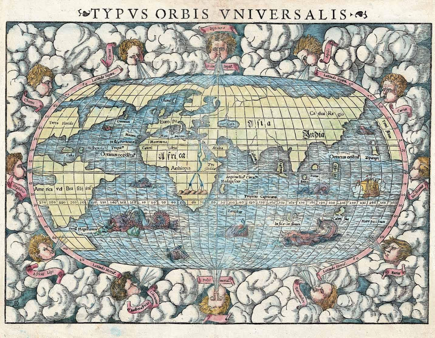
Twelve wind heads, one for each direction, and multiple sea monsters enliven this famous map of the world. Well-known among educated Europeans of the 16th century, this map was included in one of the most popular and influential books of its time, Sebastian Münster’s Cosmographia. Considered to be the first description of the world in the German language, it was later published in many other languages including Latin, French, Czech, English, and Italian.
Münster’s map is considered to have been the first to identify the Pacific Ocean (Mare Pacificum). Here, North America, still largely an unknown land, is identified as Terra Florida. Africa is shown with the Nile prominently represented on the Ptolemaic two-lake model. Japan is identified as Zipangri, an archaic term referencing Marco Polo, and Asia extends and reappears just north of America. In South America, the Strait of Magellan and the Rio de la Plata are visible. Tierra del Fuego (Land of Fire) is oversized on the assumption that it must be connected to Plato’s mythical southern continent. Europe is nearly connected to North America and Greenland by an Arctic land bridge.
Sebastian Münster (1488-1552) was a professor of Hebrew at the University of Basel, Switzerland. Münster had issued a call throughout Germany’s academic communities for cartographic information, in preparation for putting together the Cosmographia, and the book’s accuracy and scope were unprecedented. It sold well and went through 24 editions. The intricate woodcuts, by a variety of artists, were one of the reasons for its vast influence. It was produced for nearly 100 years. Most of Münster’s work was published by his sons. He died in Switzerland in 1552.

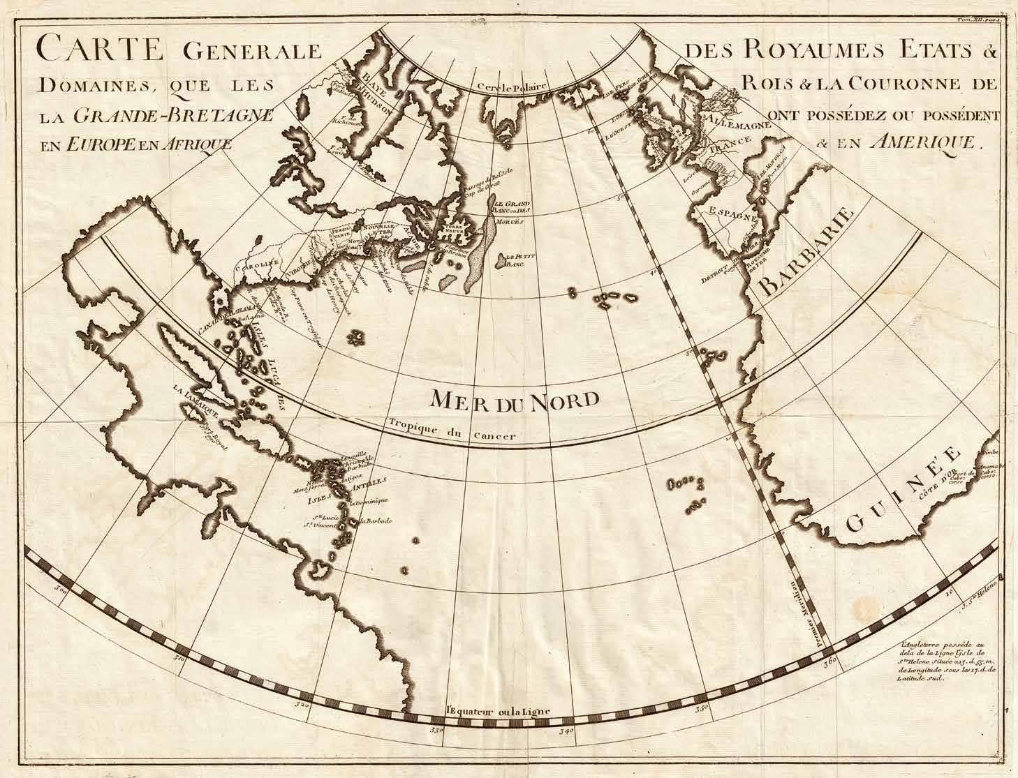

This map of the English dominions was in the form of a triangular section of the globe. It showed the British colonies in Europe, Africa, and the Americas in 1724. British claims in the New World were shown as well as British claims in France, the West Indies, Africa, and The Netherlands. From the Mediterranean to the Gulf of Mexico, and from the Polar Circle to the Equator, this map depicted the world as it was viewed by the British before the Seven Years’ War.
This map was intimately connected to the rise of the House of Hanover in England during a period of extensive global expansion of British culture and sovereignty. George Ludwig, the German Duke of Brunswick-Luneburg, became George I of Great Britain when he assumed the thrones of Ireland and England in 1714. The 1701 Act of Settlement barred Catholics from ascending to the British throne. When Queen Anne died, more than 50 contenders were ahead of George I in the line of succession; nevertheless, he was the closest living Protestant and so assumed the mantle. The Hanovers were a German royal dynasty who held titles not only in England, but also in Germany, then under the Holy Roman Empire, and France. These intricate royal networks were on display here.
This map was included in a 1724 book entitled L’Histoire d’Angleterre by Paul de Rapin de Thoyras. Although originally printed in French, L’Histoire d’Angleterre, was even more successful in its English translation, which was prepared by Tindal.
bCartographer
Paul de Rapin de Thoyras (1661-1725) was a French historian. Rapin de Thoyras fled to the Netherlands following the revocation of the Edict of Nantes in 1685. There, his scholarship attracted the patronage of William of Orange. When, in 1688, William ascended the British throne as William III, Rapin de Thoyras followed him, settling in England as royal historian.
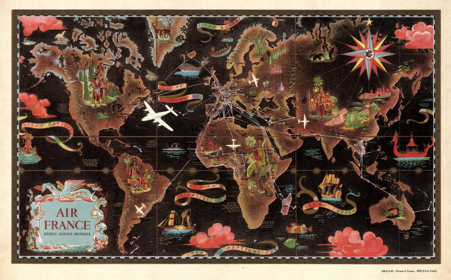

This 1947 Art Deco style map of the world was produced by Lucien Boucher as part of a series of maps intended to promote Air France. In this chromolithographic print by Perceval of Paris, vivid pastels, deep blacks, and browns stood in sharp contrast, while airliners filled the skies, and ships filled the waters. The bright white planes, doubtless representative of Air France, seemed even more attractive and comforting when flying over black waters. The complex network of Air France routes, demarcated in white, stood out against the backdrop of simplified, spacious, and nature-based illustrations.
Australia had ostriches and Asia, tigers. Bears populated the northern regions and the oceans were traversed with sails and steam. Showcasing the value of modern technology, the planes appeared powerful and safe compared to dangerous overland routes and ancient ships isolated in dark waters.
Boucher’s work for Air France was iconic and marked a high point in the modern synthesis of cartography with graphic design and advertising. Nevertheless, he has also been criticized in recent years for some of the sexist and even racist themes evident in his material. On this map, for example, women generally appeared only partially clothed, in reclining or otherwise passive poses, while the men were clothed and engaged in a variety of more energetic pursuits. Similarly, stereotypical representations of indigenous peoples decorated several continents.
Cartographer
Lucien Boucher (1889-1971) was a French artist and writer. His cartoons appeared in Le Rire, a weekly publication known for its wit and humor. Boucher later produced a number of promotional map-themed artworks, as above, for Air France. His work was a synthesis of Art Deco and Surrealistic ethics.

