
ORO Editions
In architecture and urban design, a productive city is defined as an entity combining living and the making of goods. Production within cities is not a new phenomenon. In the centuries before the industrial revolution, cities were already productive. It was only after the industrial revolution and the gradual advancement of modern technologies from the 19th century that the normative ways cities functioned were challenged. House, Precinct, Territory: Design Strategies for the Productive City develops scenariobased design models for possible urban futures, rethinking the relationships between working and living.
The contemporary city has predominantly become a place of consumption, as it is understood through western and dominant global planning frameworks. Over the last 150 years, the productive capacity of cities has progressively dwindled and been dispersed. From the late 19th century, modernist urban planners, such as Ebenezer Howard, Le Corbusier, and Clarence Stein, criticised the dense structure and appearance of existing cities. The traditional city was deemed unfit to accommodate modern factories and new technologies and was perceived as a place of “overcrowding, noise, dirt, crime, poverty, and disease”¹, not the result of a purposeful plan. An anti-density agenda emerged, basing its theories on abstract rules and regulations, encouraging functional division and sprawl as a guideline for designing the future city.
The emerging mechanised trends and demands of large-scale industries and retail operations gradually led to the marginalisation of productive sites away from city centres and spaces of living. This intentional
ORO Editions
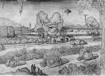
division was exacerbated by the implementation of single-use zoning. Originally known as Euclidean zoning, this approach gained popularity after use of the automobile became widespread in the early 20th century, which allowed for transit between distanceseparating land parcels. The modern city was divided into separate parcels of land, assigned to distinct uses and activities, such as commercial, residential, industrial, and recreational areas, leaving most production sites located away from city centres. Technology enabled the conception of dispersed cities. Frank Lloyd Wright’s Broadacre City, exhibited in 1934, proposed the total diffusion of city by providing each resident with an acre of land where individuals could independently manage agricultural production. The 1951 CIAM 8 event The Heart of the City proved to be critical of this dispersion when Josep Lluís Sert reconsidered the civic core as essential for the survival of modern cities. The dualities between dispersion and tightening, zoning and mixing, developed into avant-garde architectural arguments. The modernist zoning practice and its implementation in contemporary cities has extended well into the 21st century. The metropolitan footprint of all major cities is outstripped by a vast, global, peri-urban hinterland that provides the power, water, waste disposal, carbon sequestration, consumer goods, and food that cities require to exist. The peri-urbanism of production and the urbanism of consumption have become parallel domains that operate concurrently, but separately, rarely coming into contact. This disconnect is exacerbated through architecture and the design disciplines, which rarely engage with the peri-urban sites of production, and
ORO Editions
for whom the question of density in cities has become a lifestyle marketing challenge. The need to densify cities has never been more urgent. The world sits at the precipice of a global catastrophe, with the dual challenges of accelerating climate change driven by human-caused greenhouse gas emissions and biodiversity collapse, overshadowing all other issues. According to the United Nations,² the world has until 2030 to prevent irreversible damage to the world’s climate and environmental systems, with others claiming that threshold has already been crossed.³ Cities are responsible for as much as 70 percent of the world’s greenhouse gas emissions,⁴ a figure that includes the construction of cities; energy to maintain them; and waste disposal, transport, and consumables to support urban populations. While technological innovation, such as the emergence of sustainable power sources and electrifying everything have the potential to dramatically reduce the carbon footprint of cities, this process is slow, dependent on massive capital investment, and largely sits beyond the control of designers. While we can take measures to design buildings that are more efficient, we largely rely on macroeconomic and political levers in the final environmental impact of design. The largest single impact that architects and urban designers can make to the climate crisis is the tightening of our cities. The carbon footprint of a city is inextricably linked to its scale. Reducing the physical footprint of a city is the most obvious and direct way to reduce its environmental footprint—for both carbon emissions and ecological impact. While this sounds simple, the imperative to reduce global urban footprints has coincided with the
ORO Editions
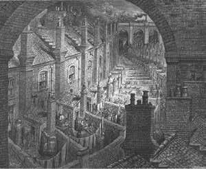
1.1 Housing in London c1870s.
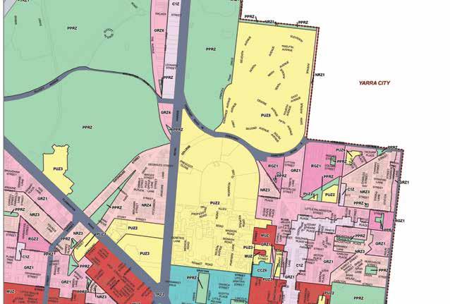
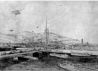
1.2 Single Use Zoning in the City of Melbourne 1947.
1.3 Broadacre City Frank Lloyd Wright 1934.
Is it possible for our cities to intensify their productive capacity by developing scenarios where living and working co-exist? Strengthening the residential property as a space of production can start from the redesign of its boundary edge. Applied at scale to the city, the repurposed boundary can unleash potential for interactive, vibrant neighbourhoods open to the agency of individuals.
Some 89% of Australia’s population now lives in cities, where residential space dominates urban development.1 Increased demand for residential growth keeps consuming industrial and agricultural lands, pushing productive areas further outside the city. As urban agglomeration continues its inexorable advance in the Australian suburbs, this issue can also be recognised at a global level. The 2020 European Union New Leipzig Charter on city transformation points to the opportunity to develop sustainable green city initiatives in tandem with the drive to more productive cities—an idea with broad implications.2 This call challenges the conventional logic of landuse policies and zoning, which favour urban space allocation to residential, office, commercial, or leisure functions, effectively leaving out productive space from cities.
However, activities of production are taking place in residential spaces, often with minimal acknowledgement, scant visibility, and a lack of appropriate infrastructure to support work practices. Since early 2020, individuals have adapted to the demands of working from home, shifting the sites
Domestic Production in the City ORO Editions
of productivity in the city, as well as working behaviours. The COVID-19 disease and the resulting pandemic, with its lockdowns and limits on mobility, accelerated the use of residential space for production, affecting the way people work at a mass scale. What is the consequence of this significant shift, and what does this mean for productivity and the economic redesign of cities in the long term? Recognising the detached suburban house as a prime location for urban production, our project embraces the dimension of the microscale to advance residential typologies through design, combining innovative domestic working arrangements with economic models evolving in neighbourhoods. Developing design strategies to support new, localised, suburban businesses can lead to revitalised communities, less commuting (lower carbon footprint), and better quality of life for increased wellbeing.
It is recognised that the productive model deriving from the phenomenon of working from home, which picked up in usage during the pandemic, created knock-on effects. Among these effects was a rise in feelings of social isolation and related health issues,3 as well as the urban effect of emptying out central business districts and traditional work and retail spaces.4 However, many of these outcomes relate to office-centred working models, whereas our project embraces the notion of production in its widest dimension, including manufacturing and production of artisanal goods and their exchange and sale— activities that seed the relaunching of localised economies and communities. Also, our analysis and design proposition are not limited to workspaces within private properties. Instead, we concentrate on liminal spaces and how they can be activated to increase networks of exchange within the neighbourhood context [3.1].
ORO Editions
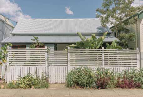
Timber fence of a detached house in West End, Brisbane.
Dormant Edge
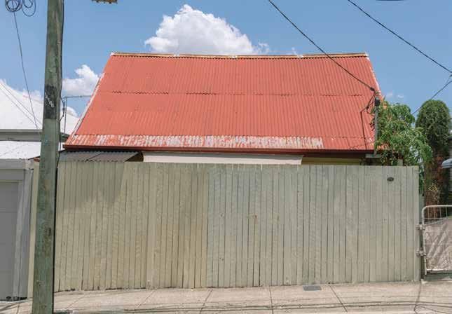
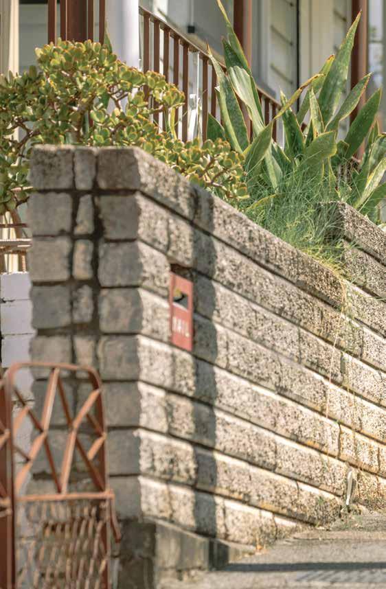
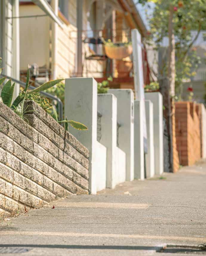
A walk around the residential suburbs of Brisbane quickly uncovers kilometres of fencing lines. All different, and yet all the same, the succession of individual fences reflects the insularity of the private properties they frame, with their palings, grass verges, gates, railings, letterboxes, garden beds, plants, and trees. The materiality of the fence line comes into play through uses of timber, brick, metal, and chain wire; or simply constructed landscaping. Different levels of division are offered, from visual segregation to shades of porosity and stark openness. The function of the fences is twofold: on one hand, they perform a traditional ornamental role, mainly through their construction, shape, and planting; on the other hand, they provide privacy and security, regulating access to the domestic site from the public domain. Limited to these functional roles, the property boundary edge reflects the concept of the suburban dormitory in its quiet and monofunctional character [3.2]. The presence of the fence is discrete and almost overlooked. Strung along the streetscape, their edge types and planting schemes reveal a conventional seriality. In the long, visual, urban perspectives of the streets, they appear with remarkable consistency, variations on an endless theme, making up the socially agreed division between public and private life. One after the other, the different fences tend to merge. Considered in their sequence, collapsing one into another, they form long ribbons that hem in residential blocks [3.3].
Understanding the collective nature of the fencing system in the suburbs, not necessarily as the ultimate limit of the private property but rather as a dominant urban element, we put forward the notion of the dormantedge. This is an edge characterised by its prolonged inactivity—apparently empty of all use but the most symbolic presentation of the house outwardly, the framing of its presence, its ultimate decorative and protective threshold. Ubiquitous, characterless, at times seemingly useless if not for its symbolic nature, the dormant edge can now be seen as an opportunity for new design investigation and intervention. Through the lens of the dormant edge, we recognise the substantial amount of underutilised urban infrastructure that the contemporary suburban city (un)consciously encompasses. With its conspicuous low-density sprawl, Brisbane is striking for the amount of fencing system that distinguishes its urban image, becoming a conducive case study.
Brisbane reflects common urban strategies present in cities developed from the 19th century into the 20th century, which were patterned on gridded planning arrangements, only to conform over time to the zoned
ORO Editions
3.2 A residential house with dormant fence line. Residential sites comprise almost 80% of Brisbane suburbs. These sites are mostly defined by dormant edges.
ORO Editions
3.3 Dormant edges in West End, Brisbane. The dormant edges of Brisbane represent an opportunity for rethinking the relationship between the public domain and private properties.
ORO Editions
ORO Editions
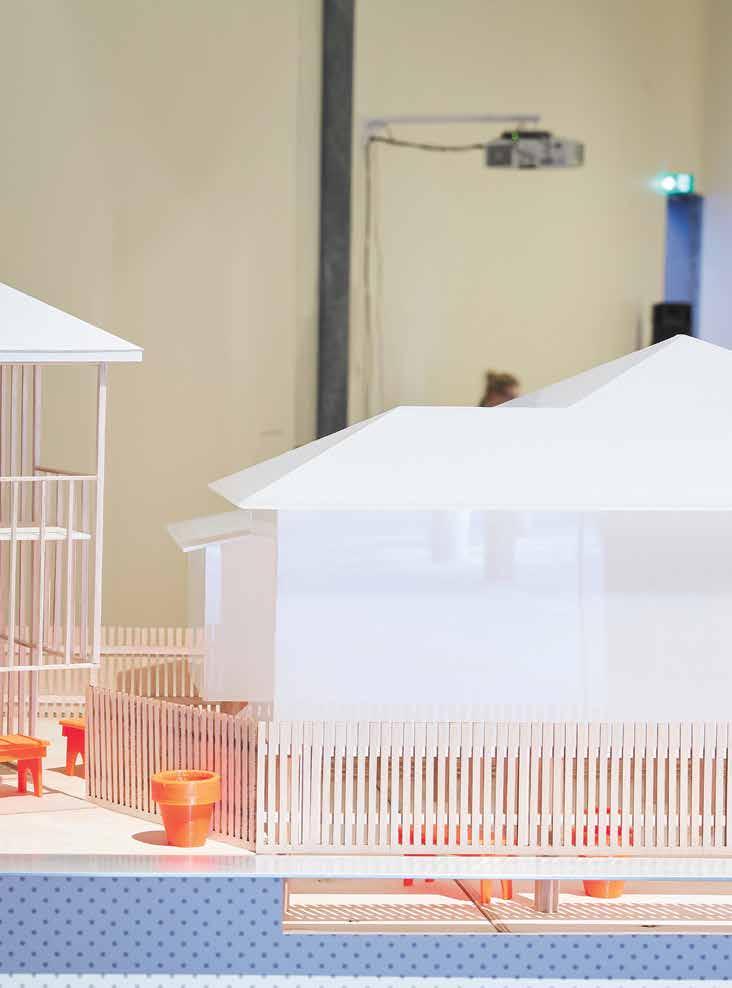
3.22 Installation model 2021 Melbourne Design Week.
The interstitial space between the Queenslander and the One Room Tower generates a miniature urban outdoor room interactive with the foothpath.

ORO Editions
ORO Editions
3.25 Axonometric view— Extending the productive edge.
A series of elements added to the domestic site create the potential for flexible use both public and private as well as productive activities.
ORO Editions

ORO Editions
4.25 Perfomative Ornamental.
Exhaust vents attached to a façade in an orderly pattern.
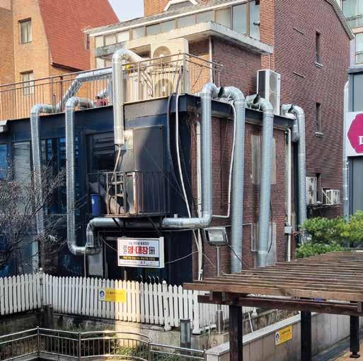
4.26 Vented Adapative Reuse.
Exhaust vents attached to a facade based on allowable insertions.
The high-tech architecture of the 1970s addressed this condition by exposing mechanical elements on façades, giving the interior space more flexibility of use with an unobstructed universal space. If the goal is to achieve more dynamic, flexible, and equitable environments, the concept of an unobstructed universal space should be prioritised.
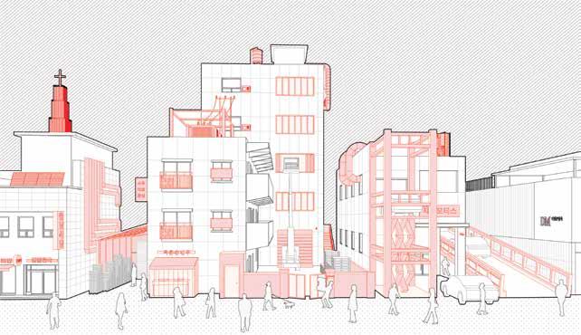
In Seongsu, production facilities expose mechanical elements in their true form on the exterior of the building as attachments. These are not fashioned after the high-tech architects, but done after the fact, as accessories for adapting and reusing existing buildings. They optimise the use of modern slab buildings allowing them to perform as factories. Some are arranged in an orderly fashion, taking an ornamental role, while others are installed as needed over time and have no formal arrangement.
ORO Editions
Productive Elements counteract the rigid zoning regulations offering variability and adaptability.
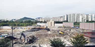
In an East Asian context, it is common to replace older buildings with new ones after a 30-year period in a tabula rasa process. In Seoul, entire blocks are demolished in order to make way for new construction that offers higher density, housing blocks being the most common. This approach has the effect of producing monocultural urban islands. Apartment blocks are typically developed in this manner, combining multiple parcels into a singular parcel to form a block. Construction companies can then develop thousands of households as a singular project, under one brand. The images in 4.27 and 4.28 illustrate this process in two dynamic neighbourhoods: Euljiro and Seongsu.
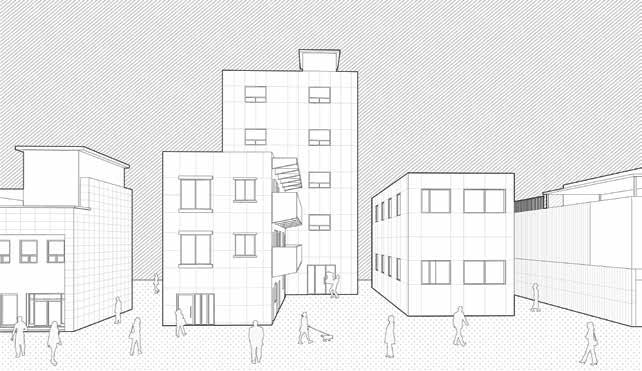
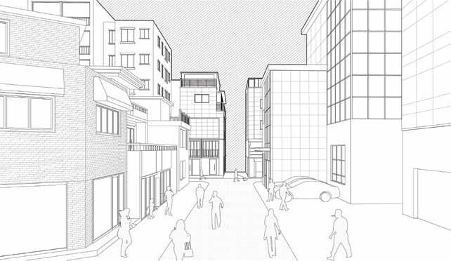
Both neighbourhoods have a diversity of programs within a fine-grained, low-rise urban fabric that allows communities to thrive. Micro-industries can also be found here, producing circular economies. With the replacement of these neighbourhoods for apartment blocks, there is a loss of diversity that may not only be a problem of displacing present communities, but also may be contradictory to the future demographics of Seoul. With Seoul’s aging and declining population, it might be more sustainable to retrofit the existing urban fabric, rather than keep building new. As the demographics in Seoul start dramatically changing, the discrepancy between the density of buildings and the density of population might cause urban voids. As an adaptive reuse strategy, focusing on elements might provide the most flexibility for retrofitting buildings into diverse multifunctional environments. Figure 4.29 and Figure 4.30 depict how, through the implementation of elements, a whole neighbourhood can change while maintaining the existing architectural background. Yet, this condition raises polemics regarding its implementation in the real world. Within the context of de-zoning the city as a way to alleviate the problems caused by modernist planning, the implementation of productive elements might still need to be restricted to certain areas, but instead of functional zoning, this can happen within typological blocks. This phenomenon is currently occurring within a low-rise, high-density urban
ORO Editions
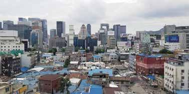

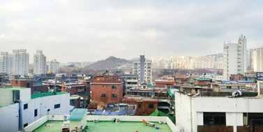
4.27 Euljiro Block Development.
Sequence of demolition of small structures to combine into a single block in Euljiro.
4.28 Seongsu Block Development.
Sequence of demolition of small structures to combine into a single block in Seongsu.
ORO Editions
4.29 Diagrams of a street façade.
Before and after the attachment of elements.
ORO Editions
4.30 Diagrams of a streetscape. Before and after the attachment of elements.

ORO
ORO Editions
Design Speculations
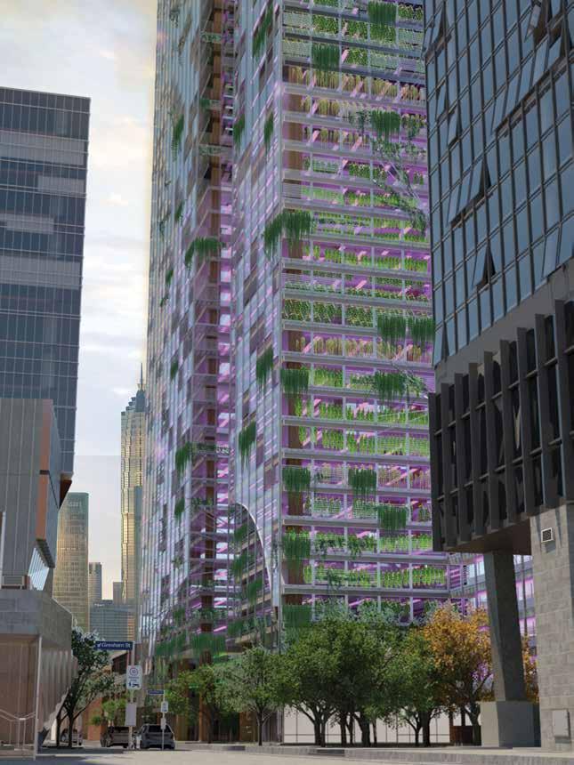
5.17 Inner City Agricultural Site.
Proposal for an ultra high-density growing facility located in the Central Business District of Melbourne.
The first design test of this urban agricultural proposition began with metropolitan- scale zoning maps to quantify available land. Land use mapping across the whole urban growth boundary identified potential sites and set out distribution of food growth areas. From this mapping, we identified four test precincts: 400 metre diameters where we tested architectural types in specific urban environments. The four precincts identified diverse work conditions. The first precinct is a high-rise context in the Melbourne central business district and existing multi-storey car parks for conversion. The second precinct is Brooklyn, a suburb ten kilometres west of the central business district of Melbourne, forming part of a low-rise territory of light industrial factory warehouses covering inner western suburbs. Wallan, the third precinct, sits at the northern extremity of the urban growth boundary. Still identifiable as a rural town on the highway to Victorian agricultural hinterlands, it now exists within the metropolitan land definition. The fourth precinct is Devon Meadows, which sits among peri-urban market gardens and orchards to the south-east.
In each instance, designs identified urban typological characteristics of the precinct and amplified these characteristics to house high-density agricultural production. In the central business district, the high-rise office tower form was replicated to hold farming rather than office space. The tower, dense with planting racks, was skinned with curtain walls and ornamental façade planting. It demonstrates the capacity of this ubiquitous model to be reappropriated for food production. In Brooklyn, the predominant existing model is large low-rise sheds, which we upgraded to three-storey height and laid out in a mat enclosure punctuated by courtyards admitting perimeter natural light and creating protected urban outdoor spaces. In Wallan, the simple strategy was to augment the dispersed collection of buildings. All that existed was retained and tall greenhouses were composed around them, re-invigorating the townscape, marking an edge to the metropolitan boundary and housing super-dense agriculture. The current agricultural focus at Devon Meadows is realised at greater intensity. High-yield greenhouse agriculture sat between, sometimes replacing fields of traditional orchard and pasture. In each case the urban model is not invented, but adapted and amplified. In a second cycle of experiments, we focused on North Melbourne, a 19th century inner industrial suburb now gentrifying. We focused on buildings customised to particular infill sites within a context of positioning intensive production across North Melbourne. Three specialised produce models were tested: aquaculture, poultry and eggs, and green plants.
ORO Editions
5.18 CBD Facility. This proposal is for Melbourne’s Central Business District. The project replaces an existing pair of multistorey carparks. The floor area ratio matches that of adjacent office and residential towers.
ORO Editions
The Urban Implications of a Self-Feeding City
The logistical implications of this productive re-distribution are significant. Trucking produce into cities and across cities creates an entire infrastructural industry around road transport. In this urban model far more food is sold (and even eaten) at the growing source and so more food is purchased at a walkable distance from home.
In many cities, there is anxiety around the health of food sources, whether by contamination of soils and water, chemical additives, or animal cruelty. The disconnect between food consumption and production and the visibility of food sources is an intensifying issue. One implication of agriculture in cities is simply that our food could be more visible. Would seeing our food growing change how it is made? This visibility connects with the urban design convention for street activation. A city filled with large agricultural industrial buildings can be activated with market outlets, and visible production, thus enlivening street edges.
This urban proposition says little about the capacity for food production at the domestic scale; the thousands of small productive gardens that exist and remain possible within the suburban housing stock. This project complements that, focusing on the commercial and industrial scale of food.
What could this urban production mean for the rural hinterland? The rural areas beyond Melbourne are under intense pressure. They are threatened by metropolitan sprawl and climate change, and they in turn threaten natural environments. Rural towns are pressured by depopulation and yet they represent a significant export industry. Three scenarios spring from urban agriculture. First, declining rural towns take on the same logic of intensifying their agricultural footprint as means to consolidating or reviving their own regional place. Second, large-scale land resources are freed to focus on export activity focused on bulk grain or pasture. That is, traditional agriculture complements the urban farm. Third, the reforestation and reversal of the environmental damage from agriculture can take place where low-intensity rural land is replaced by intensive growing.
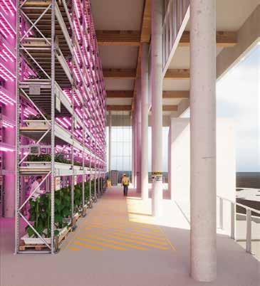
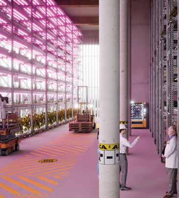
5.36 Public Access.
A view from a publicly accessible balcony at the upper growing levels. Members of the public can purchase procuce directly from the growers.
5.37 High-Intensity Growing Space.
An interior view of the growing spaces as they transition into public retail outlets—a mediation between human and nonhuman space.
ORO Editions

ORO Editions
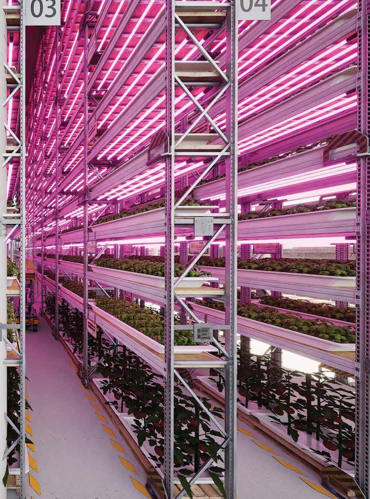
5.38 Non-Human Landscapes.
High intensity agriculture under lights with artificial growing beds can be largely automated with existing technology. This creates a future landscape where human use and comfort are not the primary design criteria. What will these spaces look like, how might they be designed and what is their contribution to the city?
ORO Editions
