ALASKAN ADVISORY

March 2023

While ABS uses reasonable efforts to accurately describe and update the information in this publication, ABS makes no warranties or representations as to its accuracy, currency, or completeness. ABS assumes no liability or responsibility for any errors or omissions in the content of this publication. To the extent permitted by applicable law, everything in this publication is provided “as is” without warranty of any kind, either expressed or implied, including, but not limited to, the implied warranties of merchantability, fitness for a particular purpose, or noninfringement. In no event will ABS be liable for any damages whatsoever, including special, indirect, consequential, or incidental damages or damages for loss of profits, revenue or use, whether brought in contract or tort, arising out of or connected with this publication or the use or reliance upon any of the content or any information contained herein.
Part 1 provides general, high level, guidance for Polar Code compliance. The guidance is intended for Alaskan waters operations.
This Advisory is only applicable for operations in polar waters around Alaska (north of 60° N) in areas defined by the IMO Polar Code. The contents of this Advisory are oriented towards operations with SOLAS certified cargo ships operating with minimal polar hazards, including:
• Sea Ice: Ice-free waters only
• Air Temperature: No low air temperature operation(s)
• Ice Accretion: Areas and times where ice accretion is not expected to occur
• Latitude: Within the limitations of Sea Area A3 and below 80° N
The principal months of application are July, August, September and October. Operation(s) outside those months may require closer evaluation than this Advisory gives guidance.
This Advisory is focused on bulk carriers and oil tankers but may be used on other vessel types such as general cargo, research, special mission ships, etc. This Advisory is not intended for yachts, fishing vessels and other non-SOLAS vessels.
The safety and environmental parts of the International Code for Ships Operating in Polar Waters (IMO Polar Code) was formally adopted by the IMO in 2014 and 2015 and entered into force on January 1, 2017, for new ships and after the first SLC Intermediate survey after January 1, 2018, for existing vessels. The mandatory sections of the Code are brought into effect via amendments to SOLAS (new Chapter XIV), MARPOL (amendment to specific Annexes) and the STCW (Standard for Training, Certification and Watchkeeping) convention. The IMO Polar Code assumes that ships are already compliant with these three conventions. Non-SOLAS ships are expected to comply with the Polar Code’s requirements as far as is possible and the IMO is creating guidance for these vessels, but non-SOLAS vessels are not considered in this publication.
The Polar Code introduces a list of potential hazards for polar water operations in introduction paragraph 3. Understanding these hazards and their applicability (how they apply or do not apply) to a given vessel’s operation is an important aspect in complying with the Polar Code and its overall safety intent. Using a Goal Based Standard (GBS) format, the process of obtaining Polar Ship Certification can range from being a significant challenge to one of relative straight forward ease. This publication aims to provide enough information to make the certification an easier one for the vessel operator.
 Notes:
1) Ice Free Water means no ice present
Notes:
1) Ice Free Water means no ice present
Following the shipowner’s polar water objectives, the normal process through the Polar Code begins with data collection. This data collection and subsequent analysis will determine which hazards are applicable and their severity to specific ships, operating areas and operating seasons.
The hazards outlined in this publication are for relatively low risk operation(s) where most of the hazards do not apply, and therefore many of the more onerous regulations do not apply. Some hazard data is provided in Appendix I of this Advisory. To obtain more complete and updated data please contact ABS, the contact info is provided on the back page of this Advisory.
After the data has been collected, the formal Operational Assessment (OA) is to be performed as required by Polar Code Part 1/1.5. The OA is required even if the intended operational limitations are like the ones specified in Section 1-1 of this Advisory. With the limitations specified in Section 1-1 the OA will generally be a simplified assessment. It is still very important to understand the hazards and how to ensure the vessel is able to avoid them. An OA considers the hazards employing a risk assessment format. If a hazard’s risk is determined to be more than the operator’s risk tolerance, then risk control or mitigation measures are proposed to lower the involved risk.
After assessing the risks for each hazard, the individual Polar Code regulations should be thoroughly examined to ensure compliance with the applicable requirements. The OA should formally be documented in a report. There are several types of OAs. The first is done before the Polar Water Operational Manual (PWOM) is written. This OA is typically focused on the specific operational profile for the vessel, such as specific ports or routes and seasons but can also be generalized for a broader area of operation. The second type of OA is done after the Polar Ship Certificate (PSC) is issued. This type of OA is done as part of the voyage planning requirements as required in Polar Code Part I-A/11. This OA considers the operational limitations on the PSC and the procedures in the PWOM. The assessment is to ensure that the planned operation will stay within the limitations (structural, stability, systems, etc.) of the vessel and that the procedures in the PWOM are adequate for the intended voyage.
The focus of this Advisory will be the initial operational assessment, achieved prior to the PWOM being written and well prior to the issuance of the PSC.
After the initial OA, the following step is generally the development of a vessel specific PWOM. The PWOM provides the crew and company with guidance for operations within polar waters. The PWOM should advise the crew how to safely operate their specific vessel in polar waters, how to stay within the operational limitations of the vessel and offer additional information in the event that operational conditions go (slightly) beyond what is expected.
A completed PWOM along with the initial OA report are submitted to ABS for review (not approval). During this review, ABS engineers will ensure the hazards listed in the Polar Code are well considered and that all applicable Polar Code requirements are met. It is noted that the IMO discussions concluded that a PWOM is not an approved document and is expected to be a living document. This means that the PWOM may evolve as operational experience in polar waters increase. A PWOM may undergo subsequent revisions without re-review by ABS, so long as the initially considered hazards and risks have not been changed. If the OA considered hazards and risks have changed from what is stated on an ABS review letter, the new OA and revised PWOM must be resubmitted to ABS for review. See Section 2-7 of this.
As part of the Polar Ship Certification process, an ABS surveyor is required to survey the vessel to ensure it has the equipment and consumables needed to follow the procedures in the PWOM and to meet the requirements of the Polar Code. Upon satisfactory completion, the surveyor will issue the PSC.
The PSC dates are aligned with the SOLAS certificates for flag States that are signatory to the Harmonized System of Survey and Certification (HSSC). Category C ships that do not have new equipment added to the vessel may be eligible for an initial survey waiver as per Polar Code Part I-A/1.3.3. If the survey waiver is the taken option, the survey will be conducted at the next scheduled survey. The details required for a PSC are provided in Appendix II, section 7 – Details for Polar Ship Certificate.
Goal-Based Standards (GBS) are comprised of at least one goal, functional requirements associated with that goal and regulations that if met ensure compliance with the functional requirements.
A list of hazards related to ship operations in polar waters are identified as a basis for the goals and functional requirements within the Polar Code. These hazards are laid out in the Introduction section of the Polar Code. The listed Polar Code hazards represent a minimum list of hazards for polar ships considered to be above and beyond the shipping hazards typically encountered by SOLAS ships.
Chapters 2 through 12 in the safety part of the Polar Code (Part I-A) begin with an established goal and subsequent functional requirements which are linked to the relevant hazards. Each of the functional requirements are then supported by prescriptive regulations as a means for compliance. In some instances, the regulations refer to international standards or classification requirements, such as different International Association of Classification Societies (IACS) Unified Requirements.
[The regulations given in the Polar Code are to be taken as mandatory in nearly all cases. The IMO recognized that alternative solutions are possible while maintaining an equivalent level of safety. In other words, a solution can be proposed that meets the functional requirements while not meeting the prescriptive regulations. To account for this SOLAS Chapter XIV, regulation 4 introduces alternative designs or arrangements. These alternative design(s) or arrangement(s) therefore meets the functional requirement(s) in the Polar Code but does not meet the prescriptive regulations. The Alternative Design and Arrangement regulation can be used for anything in Polar Code chapters 3, 6, 7 and 8. The Alternative Design and Arrangement regulation cannot be used for requirements in the other Polar Code chapters such as 9 and 10 unless authorized by the flag Administration.]
The Polar Code is not a one-size-fits-all regulatory instrument. Several thresholds are established to invoke Polar Code requirements based on the intended operational profile of the vessel. Fundamentally, more severe operating conditions will lead to a more extensive application of the Polar Code requirements. It is important for designers, owners and operators of polar ships to make appropriate decisions and assumptions about a ship’s intended operation. Discussions should be held as early as possible with the flag State or ABS to ensure a clear understanding of the applicable regulations. The primary thresholds for regulations in the Polar Code are based on the following conditions:
• Ships intended to operate in ice
• Polar ship categories
• Ships intended to operate in low air temperatures
• Ships intended to operate in areas where ice accretion is likely to occur
• Ships intended to operate above 80° N
If a ship’s planned operational profile does not expose the vessel to polar hazards, then the regulations associated with those hazards do not apply. This does not mean that these hazards can be ignored as part of the Polar Code process. The hazard should still be considered, and procedures developed to give the vessel’s master and crew guidance on how to avoid or mitigate the risk associated with these hazards. Procedures shall also be developed as contingencies in the event the expected conditions are slightly exceeded.
The goal of the risk assessments are to determine all applicable hazards associated with a specific operation, considering both the likelihood and consequence of that hazard to the vessel, the crew and the vessel’s operation. There are many ways to conduct a risk assessment. Different methods for conducting risk assessments can offer certain advantages or disadvantages depending on the desired outcome.
The Polar Code Part I-B/2.2.2 references ISO/IEC standard IEC 31010 – Risk management – Risk Assessment Techniques. This document provides an overview of different risk techniques and provides guidance for conducting risk assessments. Like the ISO/IEC standard, ABS has published Guidance Notes on Risk Assessment Applications for the Marine and Offshore Industries. The Guidance Notes offer guidance on different risk assessment techniques and provides examples of typical risks for marine applications/operations.
Suggested consequence and likelihood categories have been provided in Table 1 and Table 2 below which can be used for the risk assessment portion of the OA as outlined in Annex 3 of MSC 72/16. A sample risk matrix is also provided which can be used during an OA. When ABS facilitates an OA, a matrix like the one shown in Table 3 is used for every hazard. If more detailed itemized risk assessments are deemed necessary or there is a desire to reduce size, a tabular format can be used as shown in Table 4. In this format the same risk assessments are performed as with Table 3 but the value from one to five is entered for the consequence and likelihood categories. The resultant end risk value is determined by multiplying the consequence value and the likelihood value. It is customary to have the cells color coded based on their value, so the high risks are easily identified.
MAXIMUM
The Maximum Expected Time of Rescue (METR) should be determined by an accepted and methodical procedure such as the one in IMO SSE7/4/1 and SSE7/INF.6.
The process of determining the METR is intended to establish the endurance requirements for lifesaving appliances in polar waters the considered timer should commence when the lifesaving appliance(s) is launched. It is recognized that the ship may be at times the safest place to stay until abandonment becomes necessary. For the purposes of estimating the METR, the call for search and rescue is assumed to occur simultaneously with the launch of the lifesaving appliance(s). The end of the METR calculation is determined when the last survivor is no longer in a survival situation, depending on the equipment provided prior to abandoning.
Considering rescue by vessels of opportunity can be a complex task it is therefore suggested to ignore them when calculating the METR. It is noted that vessels sailing together, such as in a convoy, are not considered vessels of opportunity.
Alaskan Polar Waters are within the United States Coast Guard (USCG) District 17. The search and rescue capabilities of the USCG in Alaskan waters can vary from year to year and season to season. Information is required to perform calculations to justify the minimum five-day METR. When estimating the METR, it may be assumed that the USCG SAR assets will launch from Kodiak. Though, in many cases Alaskan polar water operations may have a calculated METR of less than five-days, the Polar Code specifies that five days is the minimum METR to be considered and planned for by polar ship certified vessels.
The PSC has three sections for Operational Limitations. An example of the limitations intended with this Advisory are shown in Figure 3:
Limited to ice-free waters only
5 .1 Ice Conditions
5 2 Temperature
Limited to areas where ice accretion is not expected to occur
Limited to operations in polar waters where the expected lowest MDLT for the area and season of operation is greater than or equal to -10°C
Limited to operations in Alaskan Polar waters up to an operational latitude of the lesser of:
• 80° North
5 . 3 High Latitudes
• The limitations of the sea area on the Cargo Ship Safety Radio Certificate
• The limitations of the systems used to acquire ice/environmental information
The limitations placed on the PSC are typically based upon the outcomes of the OA and the procedures included in the PWOM. For the purposes of this Advisory, it is assumed that the operational limitations will be very similar to those shown in Figure 3.
Historical environmental data for sea ice, air temperature and ice accretion shall be used to prove or justify the operational limitations. For example, the operational limitations given in Figure 2 state ice free waters only. Ice data is needed to estimate when and where ice free operations may occur. This data is also required as part of the voyage planning required in the Polar Code Part I-A/11.3.4. This data is to be available for planning purposes to ensure the vessel stays within its limitations.
A sample set of environmental data is provided in Appendix I. This data is only valid for the year of publishing for this Advisory. For other assessments an updated dataset can be obtained from ABS, see contact information on the back page of this Advisory.
The Polar Code is a goal-based standard, with several thresholds for requirements. In most cases if a hazard is not applicable to a specific operational profile, the regulations associated with mitigating the risk of that hazard are not applicable. Even though the code has these thresholds there are still a few areas where most vessels seeking a PSC require additions or modifications. A non-exhaustive example list is given below:
1. Two non-magnetic means of determining heading [Part I-A/9.3.2.2.1]
2. Airband radio [Part I-A/10.3.1.3.2]
3. Two remotely rotatable search lights suitable for searching for ice [Part I-A/9.3.3.1]
4. A4 Radio Installation (if going to an area where A4 is needed) [Part I-A/10.3.1.1]
5. Means of obtaining ice and weather information, functional up to the maximum latitude of intended operation. [Part I-A/9.3.1]
6. Manually activated flashing red stern light (if planned operations with icebreakers) [Part I-A/9.3.3.2]
7. Personal and group survival equipment as necessary to enable survival for the maximum expected time of rescue [IMO MSC.1/Circ. 1614] [Part I-A/8.3.3]
8. Heating for emergency fire pump [Part I-A/7.3.2.1]
9. Additional EPIRB (or procedures to extend battery life for the maximum expected time of rescue) [Part I-A/10.3.2.3]
10. Additional batteries for handheld GMDSS radios. (or procedures to extend battery life for the maximum expected time of rescue) [Part I-A/10.3.2.3]
11. Additional water, rations, sea sickness medication [IMO MSC.1/Circ. 1614]
12. Insulated Immersion Suits [Polar Code Part I-A/8.3.3.1.2]
Figure 3: Operational Limitations Section of Polar Ship Certificate13. Tools for de-icing/anti-icing, e.g., mallets, shovels, scrapers, anti-freeze, salt etc. (if planned operation is in an area at a time where ice accretion is expected to occur or as contingencies). [Part I-A/4.3.1.2.2]
14. Cold weather clothing for crew
Items 1 and 2 in the above list are prescriptive and mandatory for all vessels seeking a PSC. Experience has shown that a GNSS Compass may be the less onerous solution to item 1, and a handheld radio instead of a fixed installation for item 2 is easier as there are no installation drawings required for review and additionally can be included in vessel abandonment procedures.
The PSC is issued on behalf of the flag administration. The flag can waive requirements for equipment at their discretion.
The Polar Code’s Goal-Based Standard (GBS) format allows for technological improvements or acceptance of older designs based on an equivalent level of safety. The GBS format is found in Part I-A of the Polar Code where the chapters have functional requirements itemized underneath the goals. The functional requirements are the mandatory requirements. It is highly recommended to follow the regulations underneath the functional requirements but alternatives to the prescriptive requirements may be accepted by applying the Alternative Design and Arrangement Regulation (SOLAS Chapter XIV, Regulation 4). In accordance with SOLAS, the alternative design and arrangements can be used for anything in Polar Code chapters 3, 6, 7 and 8. This cannot be used for requirements in the other Polar Code chapters such as 9 and 10 unless authorized by the flag administration.
To apply for an alternative, the equivalent level of safety must be technically proven, documented and submitted to ABS for review. In most cases the flag Administration for the vessel will need to approve the proposed alternative, as the PSC is issued by ABS on behalf of the vessel’s flag. This process can take time and is therefore recommended to be avoided if possible.
For operations in July, August, September or October to most Alaskan ports, most standard SOLAS equipment may be sufficient but should be carefully evaluated during the OA. In most cases cargo ship operators indicate the preference for use of lifeboats over liferafts in polar waters due to the added protection offered by the boat. It is also very common for operators to have procedures to ensure all survival equipment is launched to maximize available resources after abandonment. Of course, the mode of abandonment must be left to the master. Procedural guidance within the PWOM may assist the master in such decisions along with specific training of the crew.
Procedures and processes to maintain equipment and system functionality can be a challenge, especially if the limitations are beyond those specified in the first section of this Advisory.
An ISO standard for polar survival equipment ISO/DIS 24452 may be referenced for additional information on lifesaving appliances.
There are many Alaska Native communities that rely on the Alaskan waters and surrounding coastline. The Alaskan coastline and waters provide subsistence resources, with many groups using the landfast ice and frozen lakes to hunt migrating animals. Marine operations during any season can disrupt the ice and thus the migratory paths of the animals and the local peoples. Marine operations can also disrupt local fish, bird and whale populations, another source of food for the Alaskan Native peoples. Recent experience has clearly indicated that previously considered annual migration/hunting periods and locations are changing and care should be taken in assessing latest information on activity in order not to interfere.
Operators should be aware of the Alaska populations in the area of operation and any local wildlife that could be interrupted or negatively impacted. While enroute it is advisable to stay within established shipping corridors and masters should contact the USCG Sector Anchorage when needed. The port facility or the vessel’s agents can also be a resource for reducing the impact of the operation on the local environment and peoples. The following sources provides additional information:
https://www.pame.is/document-library/pame-reports-new/pame-ministerial-deliverables/2021-12th-arctic-councilministerial-meeting-reykjavik-iceland/788-overview-of-low-impact-shipping-corridors-other-shipping-managementschemes/file
IMO NCSR 5/3/7 - ROUTEING MEASURES AND MANDATORY SHIP REPORTING SYSTEMS, Establishment of two-way routes and precautionary areas in the Bering Sea and Bering Strait
NCSR 5/3/8 - ROUTEING MEASURES AND MANDATORY SHIP REPORTING SYSTEMS, Establishment of three new areas to be avoided in the Bering Sea
As part of the voyage planning requirements found in Polar Code chapter 11, the master shall consider a route through polar waters taking into account current information and measures to be taken when marine mammals are encountered. As discussed in the previous section, marine operations can impact local fish, bird, and whale populations. The environmental pollution from the operation can damage the local environment in which the sea life live and hunt. Although not required by the Polar Code, the vessel’s Underwater Radiated Noise (URN) may be a consideration. The URN from the propulsion machinery and other equipment can disrupt communication between different whale species and has led to significant decrease in whale populations around busy ports such as the port of Vancouver, B.C. Canada. The lights on vessels can attract birds, causing them to strike the lights and potentially become injured or die.
To reduce the environmental impact of the operation, the vessel speed can be reduced where such actions are prudent, or routing altered. Speed reductions can lessen the underwater noise from the vessel and reduce the likelihood and consequence of striking a marine mammal. Caution should be taken to avoid the hunting and spawning grounds of the marine mammals. There are several species of land animals that also rely on local fish and marine mammals, such as Alaskan brown bears. The bears require the sustenance from the fish and marine mammals to survive the long Alaskan winters. Any interruption in the local sea life can negatively impact the shore-based wildlife. Some useful links are provided below:
https://files.worldwildlife.org/wwfcmsprod/files/Publication/file/20tn3hjotq_report_wwf_arctic_arcnet_introductory_ guide_a4_hires_final_webversion.pdf?_ga=2.62537647.2017083424.1666279484-1234889066.1666279484
https://ak.audubon.org/conservation/ecological-atlas-bering-chukchi-and-beaufort-seas
https://www.fisheries.noaa.gov/alaska/marine-mammal-protection/co-management-marine-mammals-alaska
https://files.worldwildlife.org/wwfcmsprod/files/Publication/file/3w8rtbuh00_WWF_Bering_Straits_Shipping_Report_ UPDATE.pdf?_ga=2.62537647.2017083424.1666279484-1234889066.1666279484
Part I-A/Chapter 12 of the Polar Code contains the training requirements. The aim for this Advisory is for cargo ships operating in Ice Free waters. Table 4 below is a copy from the Polar Code’s regulations and outlines the training requirements based on the vessel type and the ice conditions.
Open Waters
Basic training for master, chief mate and officers in charge of a navigational watch
Basic training for master, chief mate and officers in charge of a navigational watch
Other Waters
Advanced training for master and chief mate Basic training for officers in charge of a navigational watch
Advanced training for master and chief mate Basic training for officers in charge of a navigational watch
Note 1: Ice Free Water means no ice present If ice of any kind is present this term shall not be used
Not applicable
Advanced training for master and chief mate Basic training for officers in charge of a navigational watch
Note 2: Open Waters means a large area of freely navigable water in which sea ice is present in concentrations less than 1/10 No ice of land origin is present
Note 3: Other Waters means waters other than Ice Free or Open Waters
Note 4: Ice of land origin means ice formed on land or in an ice shelf, found floating in water
Training required in chapter 12 of the Polar Code is to be provided by an organization recognized by the vessel’s flag administration.
[The training requirements in chapter 12 of the Polar Code, are minimums. Training and experience are vital to safe ship operations, training is a sound investment in the safety of the vessel. If any ice is expected during the planed operation, ABS suggests the crew have at least the basic training, even if chapter 12 does not require it. Another option is the use of Ice Navigators to aid the master and crew in polar waters.]
Part II-A of the Polar Code contains the pollution prevention measures that are enabled by amendments to the annexes in MARPOL.
CHAPTER 1 – PREVENTION OF POLLUTION BY OIL
With the focus of this Advisory on Category C cargo ships, the requirements in this chapter are simply zero oil discharge in Arctic waters, i.e., 0 ppm. Antarctic waters were already set to zero discharge by MARPOL, Annex I, Chapter 3, Part C, Regulation 15.
Resolution MEPC.329(76) amends MAPROL Annex I, prohibiting the use and carriage for use as fuel of heavy fuel oil (HFO) by ships in Arctic waters. This comes into effect on July 1, 2024, unless the ship is:
• a Polar Code Category A ship,
• a Polar Code Category B ship, or
• a Polar Code Category C ship that was designed and built-in accordance with MARPOL Regulation 12A, “Oil Fuel Tank Protection”.
In these three cases, the prohibition of use and carriage of heavy fuel comes into effect on July 1, 2029. Please contact ABS if further information or details are required.
While in polar waters the Oil Record Book(s) should have entries if any oil operations take place in polar waters. The Shipboard Oil Pollution Emergency Plan (SOPEP) or Shipboard Marine Pollution Emergency Plan (SMPEP) may need to be updated/amended for polar water operations.
CHAPTER 2 – CONTROL OF POLLUTION BY NOXIOUS LIQUID SUBSTANCES IN BULK
This chapter prohibits the discharge of any noxious liquid substances, or mixtures containing such substances. Similarly, operation in polar waters is to be considered in the Cargo Record Book, the manual, and the SMPEP as applicable.
CHAPTER 3 – PREVENTION OF POLLUTION BY HARMFUL SUBSTANCES CARRIED BY SEA IN PACKAGED FORM
Not applicable at this time.
CHAPTER 4 – PREVENTION OF POLLUTION BY SEWAGE FROM SHIPS
For Category C Ships, this chapter in the Polar Code modifies MARPOL Annex IV by treating ice in the same way MARPOL treats land. For example, MARPOL Annex IV Regulation 11.1.1 states:
“the ship is discharging comminuted and disinfected sewage using a system approved by the Administration in accordance with regulation 9.1.2 of this Annex at a distance of more than 3 nautical miles from the nearest land, or sewage which is not comminuted or disinfected, at a distance of more than 12 nautical miles from the nearest land, provided that, in any case, the sewage that has been stored in holding tanks, or sewage originating from spaces containing living animals, shall not be discharged instantaneously but at a moderate rate when the ship is en route and proceeding at not less than 4 knots; the rate of discharge shall be approved by the Administration based upon standards developed by the Organization”
whereas Polar Code Part II-A/4.2.1 states:
“.1 the ship is discharging comminuted and disinfected sewage in accordance with regulation 11.1.1 of MARPOL Annex IV at a distance of more than 3 nautical miles from any ice-shelf or fast ice and shall be as far as practicable from areas of ice concentration exceeding 1/10; or
.2 the ship is discharging sewage that is not comminuted or disinfected in accordance with regulation 11.1.1 of MARPOL Annex IV and at a distance of more than 12 nautical miles from any ice-shelf or fast ice and shall be as far as practicable from areas of ice concentration exceeding 1/10; or
.3 the ship has in operation an approved sewage treatment plant certified by the Administration to meet the operational requirements in either regulation 9.1.1 or 9.2.1 of MARPOL Annex IV, and discharges sewage in accordance with regulation 11.1.2 of Annex IV and shall be as far as practicable from the nearest land, any ice-shelf, fast ice or areas of ice concentration exceeding 1/10.”
This Polar Code chapter modifies the MARPOL Annex V Regulation 4 requirements to include ice in the 12 nautical mile limit for food waste discharge. The discharge of food wastes onto ice is prohibited, and any discharge of animal carcasses is prohibited. The Garbage Record Book and Garbage Management Plan are to consider polar water operations.
Resolution MEPC.329(76) amends MAPROL Annex I, prohibiting the use and carriage for use as fuel of heavy fuel oil by ships in Arctic waters. Heavy fuels are banned from Antarctic waters by MARPOL Annex I, Chapter 9. The ban for Arctic waters comes into effect on July 1, 2024 unless the ship is a Polar Code Category A or B ship (Ice Class PC7 up to Ice Class PC1) or was designed and built-in accordance with MARPOL Regulation 12A, “Oil Fuel Tank Protection.” In these cases, the prohibition of use and carriage of heavy fuel comes into effect on July 1, 2029.
The state of Alaska is the Northern most state of the United States of America, bordering Canada to the East and Russia to the west across the Bearing Strait. Alaska has a small population compared to other US states but is very rich in natural resources. The abundance of resources and required Northern resupply leads to the majority of the marine traffic in Alaskan waters.
Note to vessel operators: All the towns/villages or coastlines in Alaska, including the ones listed below should not be approached by a marine vessel, unless a matter of emergency or previous arrangements with the community. All communities rely on harvesting marine resources year-round and lack of prior arrangement may disrupt activities or disturb culturally important locations. For further information see these research vessel standards of care developed by communities in the region:
http://nebula.wsimg.com/3f6e3c7518e6de0f4b323a47884e6748?AccessKeyId=4913A243119CE1325FB9&disposition= 0&alloworigin=1
Red Dog: (This port is specifically covered in Part 3 of this Advisory). Red Dog is a port that services the Red Dog mining operation. The port is located at 67° 34’ 42” N x 164°03’ 30” W and is capable of handling up to 1.4 million tons of zinc and lead concentrates annually during the summer shipping season (June/July to middle or end of October). The port is considered a remote location and has no services available such as provisioning, repairs, freshwater or bunkers. Vessel loading operations are conducted offshore at an anchorage site roughly three to five miles off the coast. More information is available in documentation for vessel owners provided by the port operations.
Nome: The port of Nome is located at 64° 29’ 54” N x 165° 25’ 48” W on the southern side of the Seward Peninsula in central western Alaska. The south dock (City) is located on the Port of Nome’s causeway. This dock is approximately 61 m long with a water depth of approximately 6.9 m and typically handles bulk cargo and fuel deliveries for the community. The north dock (WestGold) is approximately 58 m long with 6.9 m water depth and handles rock and gravel exports. The north dock is also used for loading and unloading heavy equipment. A port expansion project is planned to extend the capabilities of the port.
Kotzebue: is a port located approximately 300 km northeast of Nome at 66° 53’ 49” N x 162° 35’ 18” W . The wharf receives containerized and general cargo as well as petroleum products. The wharf has berthing for approximately 122 m with 3 m of water depth.
Point Barrow: Located at the northernmost point of Alaska in the town called Utqiagvik. There is currently no docking or berthing facilities at point Barrow, but it included in this list for its geographical significance. The community resupply happens by air or by barges during the ice-free period. Cruise ships stay offshore and have sent passengers ashore using small tenders. There are motivations to build a small conventional port at Point Barrow, but construction has not started as of the publishing of this Advisory.
St. Lawrence Island: The town of Savoonga is a small town of about 700 people located central north of St. Lawrence Island. The other town on the island is Gambell, located on the northwest corner of the island also with approximately 700 people. Neither town has a dock or wharf capable of accommodating a commercial cargo ship. Fuel and provisions for the towns are typically provided by barges.
Prudhoe Bay: A small port on the north coast of Alaska located at 70° 19’ 32” N x 148° 42’ 41” W . The town serves primarily to support the Prudhoe Bay Oil Field.
Little Diomede Island: An island located at 65° 45’ 15” N x 168° 55’ 15” W. As of 2022, the island has a permanent population of 77. The Island has no dock or means of berthing a commercial vessel. Cruise ships have stopped at the island, anchored offshore, sending guest ashore via tendered launch. Community resupply is normally provided by helicopters, but there are usually 1 or 2 tank barges annually to refill the community’s fuel tanks.
The popular Alaskan port of Anchorage is located at 61° 14’ 25” N x 149° 53’ 10” W within Cook Inlet. Similarly, Valdez is located in Prince William Sound at 61° 7’ 51” N x 146° 20’ 54” W . Both ports are north of the nominal 60° N boundary for polar waters but these ports are not considered to be polar waters in accordance with the Polar Code. Therefore, the Polar Code does not apply to operations in these Southern Alaska inlets that reach north of 60° N. These ports can have sea ice, low temperatures, ice accretion and other low temperature related hazards, therefore due caution for operations is advised and the Polar Code process can be used to manage the risks of operations in these waters. The U.S. Coast Guard published “Operating Guidelines for Ice Conditions in Cook Inlet ” which should be referenced for vessels planning operations to Cook Inlet.
See Normal Additions or Modifications to a Ship to Receive a Polar Ship Certificate of this Advisory.
In accordance with the Polar Code, the shipowner is required to undertake an OA for all ships entering polar waters. The OA is required to establish the applicability of the various polar hazards, identify risk control measures (RCMs) and operational limitations to be listed on the PSC. The shipowner is to evaluate the ship’s design features and the ship’s operational procedures against possible hazards and to identify and mitigate any risks during the operations in polar waters. For existing vessels, the outcomes of the assessment should be incorporated in the operational procedures and included in the PWOM to avoid, minimize or respond to the risks.
The Polar Code specifies that the assessment should be the basis of:
1. Defining the operational limitations to be listed on the PSC
2. The operational procedures in the Polar Water Operational Manual (PWOM) to mitigate the identified polar hazards
3. The means and procedures for the survival of crew in the event of abandonment
Most prudent operators carry out these types of assessments (e.g., risk assessments) on a regular basis as part of their internal safety management systems. The required assessment in the Polar Code is not intended to replace existing risk management practices; rather, it aims to formalize best practices for ships operating in polar waters.
It is recommended in the Code to carry out the OA in accordance with established best practices which, in principle, involve:
A Hazard Identification Step — Sources of hazards are identified in the Introduction to the Polar Code. The relevance of these sources of hazards will be determined, primarily, by the environmental conditions. For example, ice accretion
is a hazard source but if the ship is not likely to operate in areas subject to ice accretion, then the ice accretion hazard is not relevant. Thus, relevant hazards can be assessed by considering the environmental conditions.
Model for Analysis of Risks — For the most part, the Polar Code has already taken the common hazards and provided regulations to mitigate the risk associated with them. The Polar Code is therefore a useful tool in modeling and assessing risk. However, any risk modeling also needs to include areas where the Polar Code explicitly leaves the provision of mitigation means up to the assessment.
Implement Risk Control Measures — Polar Code prescriptive requirements may be used as risk control measures. In most cases the prescriptive regulations in the Code will be suitable means for mitigation. However, for areas where there are no regulations that lead to explicit procedures or equipment, such as abandonment, risk control measures need to be deployed.
ABS generally follows the practice outlined in the ABS Guidance Notes on Risk Assessment Application for the Marine and Offshore Oil and Gas Industry. The risk assessment workshop is recommended to bring together competent operational personnel, shore based technical and support staff and polar subject matter experts (SMEs). The following steps are suggested:
A. Define the intended operational parameters:
• Operational area, destination, transit route or the range of latitude
Period/dates of operations in polar waters
Polar Service Temperature (PST) if the ship is intended to operate in low air temperatures
• Escorting operation, escorted operation or independent operation
• Method of assessing operational limitations in ice, such as the Polar Operational Limit Assessment Risk Index System (POLARIS) or other methods
• Maximum Expected Time of Rescue (METR)
B. Define the intended operational scenarios taking into consideration the following:
• Operation in low air temperature
• Operation in ice
• Operation in high latitude
• Potential for abandonment onto ice or land
C. Identify relevant hazards defined in the Polar Code and any additional hazards specific for the ship or the intended operations.
• Ice, topside icing, low temperature, extended period of darkness or daylight, high latitude, remoteness, lack of crew experience, lack of suitable emergency response, rapid changing and severe weather, sensitive natural environment — identified in the Polar Code
• Any additional hazards specific for the ship or the intended operations
D. Develop a model for analyzing risks considering probability and consequence levels for the defined operational scenarios.
E. Assess the risks using a selected methodology and determine acceptability. Consideration for the vessel’s design characteristics and past operational experience, including experience of sister vessels.
F. Identify current or develop new risk control measures that aim to reduce the frequency (i.e., probability) or mitigate the consequence of failures through design features, operational procedures or company training policies. The accepted risk control measures are to be documented in the PWOM.
G. If there is no available risk control option or the risk is not acceptable, the operational parameters should be revised to lower the risk.
The Thresholds in the Regulation section of this Advisory contains recommended consequence and likelihood categories that may be used during the assessments.
The OA is the key to a successful polar code application, it forms the basis upon which the PWOM is developed. It is also the basis upon which the PWOM will be reviewed. The OA process is one that shouldn’t be taken lightly and can take some considerable time. Caution is advised to not underestimate the level of effort required to perform and document a good OA.
An example OA Report for operation to Red Dog is given in Appendix II of this Advisory.
To obtain a PSC the vessel must have a PWOM on board. The requirement for the PWOM is the entirety of Polar Code chapter 2 which states the following:
2.1 Goal
The goal of this chapter is to provide the owner, operator, master and crew with sufficient information regarding the ship’s operational capabilities and limitations in order to support their decision-making process.

2.2.1 In order to achieve the goal set out in paragraph 2.1 above, the following functional requirements are embodied in the regulations of this chapter.
2.2.4 The Manual shall include or refer to specific procedures to be followed in the event of incidents in polar waters.
2.2.5 The Manual shall include or refer to specific procedures to be followed in the event that conditions are encountered which exceed the ship’s specific capabilities and limitations in paragraph 2.2.2.
2.2.6 The Manual shall include or refer to procedures to be followed when using icebreaker assistance, as applicable.
2.3 Regulations
2.3.1 In order to comply with the functional requirements of paragraphs 2.2.1 to 2.2.6, the Manual shall be carried on board.
2.3.2 In order to comply with the functional requirements of paragraph 2.2.2, the Manual shall contain, where applicable, the methodology used to determine capabilities and limitations in ice.
2.3.3 In order to comply with the functional requirements of paragraph 2.2.3, the Manual shall include risk-based procedures for the following:
.1 voyage planning to avoid ice and/or temperatures that exceed the ship’s design capabilities or limitations;
.2 arrangements for receiving forecasts of the environmental conditions;
.3 means of addressing any limitations of the hydrographic, meteorological and navigational information available;
.4 operation of equipment required under other chapters of this Code; and
.5 implementation of special measures to maintain equipment and system functionality under low temperatures, topside icing and the presence of sea ice, as applicable.
2.3.4 In order to comply with the functional requirements of paragraph 2.2.4, the Manual shall include risk-based procedures to be followed for:
.1 contacting emergency response providers for salvage, search and rescue (SAR), spill response, etc., as applicable; and
.2 in the case of ships ice strengthened in accordance with chapter 3, procedures for maintaining life support and ship integrity in the event of prolonged entrapment by ice.
2.3.5 In order to comply with the functional requirements of paragraph 2.2.5, the Manual shall include risk-based procedures to be followed for measures to be taken in the event of encountering ice and/or temperatures which exceed the ship’s design capabilities or limitations.
2.3.6 In order to comply with the functional requirements of paragraph 2.2.6, the Manual shall include riskbased procedures for monitoring and maintaining safety during operations in ice, as applicable, including any requirements for escort operations or icebreaker assistance. Different operational limitations may apply depending on whether the ship is operating independently or with icebreaker escort. Where appropriate, the PWOM should specify both options.
2.2.2 The Manual shall include information on the ship-specific capabilities and limitations in relation to the assessment required under paragraph 1.5.
2.2.3 The Manual shall include or refer to specific procedures to be followed in normal operations and in order to avoid encountering conditions that exceed the ship’s capabilities.
The PWOM provides guidance to the master, crew and company of the vessel on how to safely operate that specific vessel in the polar environment as defined in the OA. The PWOM should clearly indicate the vessel’s capabilities in air temperatures and sea ice. These limitations can simply be:
• No low air temperature as defined in the Polar Code (MDLT < -10°), and avoiding cooler air temperatures such as areas and times where the air temperature is forecasted to be below XX°C. The temperature is to be ship specific and determined by the owner/operator but should never exceed the temperatures for which the hull steel grades are suitable (ABS MVR 3-1-2/3.5) or the ratings of systems and equipment related to safety or environmental protection.
• No sea ice (Ice free waters only)
Or the limitations can be more specific to the vessel’s capabilities, which are linked to the vessel’s ice class for sea ice operations and rated temperature for hull, machinery, lifesaving appliances, navigational equipment, etc.
The manual must give the operator guidance on how to avoid operating in times and areas where the vessel’s capabilities may be exceeded. The PWOM should also give contingency procedures on actions for the crew if the vessel’s capabilities are slightly exceeded.
The Polar Code’s Appendix II contains a template table of contents for a PWOM. Some flags make this format mandatory and ABS highly recommends following this format as it makes the manual more recognizable for new crew members and makes for easier review.
Since the PWOM is guidance for a crew on how to safely operate that specific vessel in polar waters the PWOM must be ship specific. Any manual found containing terms such as “if fitted” will be flagged by ABS review engineers as not being ship specific. It doesn’t do a crew any good to have a great deal of procedures for equipment or systems that the ship does not have. The body of the PWOM which contains the procedures should not contain non-relevant information. Information that may be useful to the crew but is not ship specific may be included in an appendix.
A PWOM is a reviewed document and not an approved document. This was an intentional distinction from the IMO as it is expected that a Recognized Organization (RO) should not approve an operator’s procedures for safe polar operations. It is also expected that as more experience is gained with the vessel and vessel’s personnel in polar conditions that the procedures will evolve. It is the expectation of ABS that a reviewed PWOM will be updated regularly. Most updates are not expected to require a re-review unless the hazards or operational limitations are to be changed, the manual has significantly changed since the initial review or if significant modifications/alterations to the vessel have taken place which would impact the manual. During an annual survey the ABS surveyor will check the PWOM on board and compare with the PWOM that was reviewed.
This part of the Advisory is intended to be a quick reference specifically for the common polar waters port of Red Dog. Additional information and other considerations are given in the other parts of this Advisory and are recommended reading.
Normal operations to Red Dog are for the ice free and warmer air summer months, generally from June through October. Before June the air has warmed but the sea ice has not yet melted. Beginning in October the air temperature quickly drops below freezing but sea ice has not yet begun to form. For this Advisory it is assumed that the operational limitations will be:
1. Ice Free conditions
2. Non low air temperature
See Figure 3 for more detailed operational limitations.
As a consideration of changing Arctic ice patterns, in more recent years, small multiyear ice floes have been spotted drifting south in the northern Bearing Sea as the first year ice in the area is breaking up in the spring and early summer. The Polar ice pack conditions are changing, with extents receding, the first year ice is less present. Lower amounts of first year ice allows the multiyear ice to become more freely mobile. This is more likely in the early part of the season when the first year ice is melting but has occurred prior to that regular start of the Red Dog season.
It is recommended that the items listed in Section 2-5: Normal additions or Modifications to a ship to get a Polar Ship Certificate, be reviewed. The most frequently required items for a bulk carrier going to Red Dog are:
1. Two non-magnetic means of determining heading [Part I-A/9.3.2.2.1]
2. Airband radio [Part I-A/10.3.1.3.2]
3. Two remotely rotatable search lights suitable for searching for ice [Part I-A/9.3.3.1]
Two Non-magnetic Means Guidance: Polar Code Part I-A/9.3.2.2.1 states: “ships shall have two non-magnetic means to determine and display their heading. Both means shall be independent and shall be connected to the ship’s main and emergency source of power.”
The two non-magnetic means of determining heading is the most common equipment needed for ships calling Red Dog. SOLAS ships are required to have a gyrocompass which counts as the first means. The second means can be:
• A GNSS Compass (satellite compass)
A second gyrocompass
Another means that is acceptable to the flag Administration of the vessel
These systems can be connected into the integrated bridge, but if so, they must meet the requirements in SOLAS Chapter V. If they are not connected to the integrated bridge system, this should be mentioned in the PWOM that this device is for polar operations.
Airband Radio Guidance: Polar Code Part I-A/10.3.1.3.2 states: “…equipment for voice communications with aircraft on 121.5 and 123.1 MHz.”
There are many different models of Airband radios. Some radio types are a fixed type that require installation. The installation may be subject to engineering review; therefore, it is recommended that a handheld radio be used. The only requirement is that the radio needs to be able to transmit and receive on the two aircraft emergency channels: 121.5 and 123.1 MHz. It is recommended to confirm this send and receive ability before ordering the radio.
Search Lights Guidance: Polar Code Part I-A/9.3.3.1 states: “…with the exception of those solely operating in areas with 24 hours daylight, shall be equipped with two remotely rotatable, narrow-beam search lights controllable from the bridge to provide lighting over an arc of 360 degrees, or other means to visually detect ice.”
The original intention for this requirement when the Polar Code was being developed was for high powered (~2,000 W) Xenon searchlights as is seen on many polar going icebreakers. This type of search light, or equivalent, may be appropriate for ships that need to operate in ice in the dark.
For ships that will operate in ice-free waters only, the searchlights or other means to visually detect ice are still required unless operating in polar waters with 24 hours of daylight. Normally this requirement is met by vessels having lights as required by the Suez Canal Rules of Navigation; a large searchlight forward and two bridgewing projectors. If there is to be any nighttime navigation in polar waters, the searchlight/projectors must be able to project light well beyond the bow of the ship and be able to be directed to highlight possible ice sightings. Some vessels have alternative forms of lighting that may fall under the “other means to visually detect ice”. When this is the case, it is expected that the vessel’s PWOM will contain guidance to the crew stating that while transiting at night in polar waters, the vessel’s master shall operate at a speed considering the vessel’s stopping distance or maneuvering characteristics and the range at which ice floes can be detected.
Some special considerations can be made for the “…or other means to visually detect ice.” This is not clearly defined in the Polar Code. For this, the operations and other illumination sources may be considered provided the vessel’s speed and stopping/maneuvering is such that it is not out running the lighting system. Statement to this effect would need to be in the PWOM. Other alternatives such as thermal imagery, ice radars, drones, etc. may also be considered with sufficient technical justification and redundancy.
The remotely rotatable requirement is intended to be directly controlled from within the bridge. With bridgewing projectors this can be achieved by manually directing the lights or by assigning crew to control the light and radio communication from the navigation officer.
An OA is a mandatory step to be taken for all ships entering polar waters {Polar Code Part I-A/1.5}. In the initial assessment it is expected that the vessel’s capabilities will be closely examined and identified. It is also required that all the hazards for the planned polar water operations be evaluated carefully, and risk control measures developed if the risks are determined to be unacceptable. It is also normal during this assessment that the Polar Code’s regulations be examined thoroughly to ensure the vessel complies with the regulations. A PSC may be valid for all polar waters, provided the PWOM covers the appropriate hazards and risk control measures for those hazards. In a case where an OA was initially performed considering a specific route/location, but the PWOM was developed reasonably well for other polar water operations, a revised OA may be needed for the new route(s)/location(s). It is expected that this assessment will be such that it evaluates the new route’s/location’s hazards to ensure that the limitations on the PSC will not be exceeded, and that the procedures in the PWOM are sufficient for managing the risks.
The OA process is a good opportunity for those not familiar with polar operations to become more aware of the potential hazards.
The recommended steps to take for a Red Dog OA are:
1. Review available environmental data (see Appendix I for example) to confirm:
a. Ice free conditions
b. Not low air temperature
2. Create an OA Report. The example/template given in Appendix II may be useful.
3. Go through the risk assessments, documenting the hazards and their associated risks.
4. Go through the Polar Code regulations. Using a table format like the one given in the addendum of Appendix II has proven to be useful. This table forms part of the OA report and gives evidence that the Polar Code regulations are all being met. Any applicable regulations in Polar Code chapters 3, 6, 7 or 8 that are not met may be considered for an alternative design or arrangement.
5. If any risk control measures (RCM) are applied, revisit the risk matrices, indicating how the risk is being controlled and how the risk level has dropped. In the example OA report this is achieved by marking “original risk” where the initial assessment placed the risk level, and then an “X” for the risk level after the RCM is applied or an itemized risk matrix as shown in Table 4.
For an operation to Red Dog for a non-ice strengthened bulk carrier in the summer months, many of the sections of the PWOM will not apply. Any section that is found to be not applicable to the intended operation cannot be skipped but should be indicated that the section is not applicable to the intended operation.
It is very important to write the PWOM in a way that is appropriate for the intended polar operations for the vessel. For example, a PWOM for Red Dog that goes into great detail on safe operations in ice gives an indication that the operator intends to operate the vessel in ice. This will raise questions during the review as to whether the operator truly understands the hazard or if the operation is going well beyond Red Dog.
Many PWOMs submitted to ABS for review include references to/from the Canadian Coast Guard’s “Ice Navigation in Canadian Waters.” An example figure that is often used in PWOMs from this publication is given below in Figure 4. The Ice Navigation in Canadian Waters publication is a very good document and highly recommended reading, but most of the concepts within this document are intended for ice going vessels. Including such information in a PWOM for a vessel limited to operations in ice free waters only is misleading and will very likely result in technical comments. If operations in ice is expected and these figures are required to be in the PWOM, this Advisory is not applicable.
A PWOM specifically for Red Dog shouldn’t be too long or complex An example/template PWOM for a bulk carrier specifically dedicated to Red Dog operations is given in Appendix III
Figure 4: Figure 49 from the Canadian Coast Guard Ice Navigation in Canadian Waters Source: Ice Navigation in Canadian Waters, available here for download: https://www ccg-gcc gc ca/publications/icebreaking-deglacage/ ice-navigation-glaces/page01-eng htmlABS participated at the IMO during the development of the Polar Code and has a deep understanding of the requirements, the background behind the requirements, and the intentions of the Code. ABS has taken this vast experience and knowledge of the Polar Code to develop services to help shipowners/operators minimize risks, while also minimizing the level of effort required to progress through to obtaining a PSC.
These services evolve over time, and it is therefore best if the ABS polar SMEs are contacted for the latest service offerings. These services range from hazard data collection and analysis through to a fully facilitated OA and final survey for obtaining a PSC. ABS SMEs may be contacted via the contact information on the back page of this Advisory.
The ABS Harsh Environment Technology Center (HETC) was established in conjunction with Memorial University in St. John’s, NL, Canada. The HETC is partially a research and development center and partially an advisory service for polar and low temperature operations. The ABS HETC has a team of engineers that are experts on many things including Polar Code application, ice class, winterization and ice loads on various machinery, hulls and structures, including light and non-ice strengthened structures.
Tools — The ABS HETC has developed an in-house tool for evaluating environmental polar hazards such as sea ice, air temperature and ice accretion. The outputs from this tool are a series of figures for various locations around the world, and a color scheme that depicts the level of the hazard. Sea ice data is processed using the IMO POLARIS methodology and is presented in RIO groupings of 10. Temperature is processed following the Polar Code’s definition of MDLT, or the IACS rules definition of MDAT. Ice accretion is a topic of research and development at the HETC, future tools are under development, current tools use internationally published methodologies to estimate ice accretion.


The output from these tools is used in many ways, such as ice class selection which is not discussed in this Advisory. For the application to polar waters and compliance with the Polar Code, the outputs from these tools are used in the OA to focus the operational window or determine operational profile capabilities for the vessel to optimize chartering opportunities. When multiple years of data are used, this analysis serves to meet the requirements of Polar Code Part I-A/11.3.4
Operational Assessment Preparation — Gathering data and becoming familiarized with the requirements of the Polar Code can be a challenge. The ABS HETC has years of experience with offering training and preparing company, vessel and operationally specific guidance. The guidance is in the form of a report that the HETC calls the “Pre-OA Report” (Pre-Operational Assessment Report). This report contains the environmental hazard analysis mentioned above, some interpretation as to what those hazards mean for the intended operational profile (if possible). The report also gives guidance on what risk assessments should be made, considerations during the assessments and suggestions for risk control measures. The Pre-OA Report can save significant overall time and provide a guide in accomplishing the mandatory OA, follow on PWOM and Polar Ship Certification.
Operational Assessment — The ABS HETC SMEs can join you for an OA. These SMEs will guide the process, making sure you are asking and answering the right questions and make sure you do not go off track. ABS HETC SMEs have years of experience with various risk control measures and can guide you based on past experiences. ABS SMEs will document the process and create an OA report that can be used to write a PWOM.
Sea Ice Air TemperatureABS American Bureau of Shipping
AIRSS Canadian Arctic Ice Regime Shipping System
CatZOC Categories of Zone Of Confidence
CFR Code of Federal Regulations
DIS Draft International Standard (ISO)
EPIRB Emergency Position-indicating Radio Beacon
GBS Goal Based Standard
GMDSS Global Maritime Distress and Safety System
GNSS Global Navigation Satelite System
HETC Harsh Environment Technology Center
HSSC Harmonized System of Survey and Certification
IACS International Association of Classification Societies
IEC International Electrotechnical Commission
IMO International Maritime Organization
ISO International Standards Organization
MARPOL Marine Pollution Prevention
MDAT Mean Daily Average Temperature
MDLT Mean Daily Low Temperature
MEPC Maritime Environmental Protection Committee (IMO)
METR Maximum Expected Time to Rescue
MSC Maritime Safety Committee (IMO)
NSR Northern Sea Route
NWP Northwest Passage
OA Operational Assessment
PC Polar Class
POLARIS Polar Operational Limit Assessment Risk Index System
PSC Polar Ship Certificate
PST Polar Service Temperature
PWOM Polar Water Operational Manual
R&D Research and Development
RCM Risk Control Measure
RIO Risk Index Outcome
RO Recognized Organization
RV Risk Value
SitRep Situation report
SLC SOLAS Safety Construction
SME Subject Matter Expert
SMPEP Shipboard Marine Pollution Emergency Plan
SOLAS Safety Of Life At Sea
SOPEP Shipboard Oil Pollution Emergency Plan
SSE IMO Sub-Committee on Ship Systems and Equipment
STCW Standard for Training, Certification and Watchkeeping
USCG United States Coast Guard
This data is produced by the ABS Harsh Environment Technology Center (HETC). Updated or higher resolution data is available upon request. Request for data can be made by the contacts on the back page of this Advisory.
The IMO has developed a harmonized methodology for assessing operational limitations in ice called the Polar Operational Limit Assessment Risk Indexing System (POLARIS). The detailed background and description of this system are described in an IMO Circular – MSC.1-Circ.1519. The system incorporates experience and best practices from the Canadian AIRSS system and the Russian Ice Certificate concept with additional input provided by other coastal administrations having experience regulating marine traffic in ice conditions. The basis of POLARIS is an evaluation of the risks posed to the ship by ice conditions using the World Meteorological Organization (WMO) nomenclature and the ship’s assigned ice class (or lack thereof).
POLARIS can be used for voyage planning or on-board decision-making in real time on the bridge. As with any methodology, it is not intended to replace an experienced Master’s master’s judgement. POLARIS assesses ice conditions based on a Risk Index Outcome (RIO) which is determined by the following simple calculation:
RIO = (C1 x RV1 ) + (C2 x RV2 ) + (C3 x RV3 ) + (C4 x RV4 )
Where:
• C1 …C4 — Concentrations of ice types within ice regime
• RV1 …RV4 — Corresponding risk index values for a given Ice Class (see Table 6)
The Risk Values (RV) are a function of ice class, season of operation, and operational state (i.e., independent operation or icebreaker escort). An example table of RVs is shown in Table 6. Risk levels are higher with increasing ice thickness and decreasing ice class. POLARIS establishes RVs for the seven (7) IACS Polar Classes, four (4) Finnish-Swedish Ice Classes, and non-ice strengthened ships. For an example non-ice strengthened category C ship, only the bottom row of risk values needs to be considered.
A positive RIO indicates an acceptable level of risk where operations may proceed normally. A negative RIO indicates an increased risk level, potentially to unacceptable levels. Criteria is established, as shown in Table 7. For negative RIOs the system suggests that operations should both be stopped and reassessed or proceed cautiously with reduced speeds (IMO terminology is “subject to special consideration”). For a Category A or B ship, IMO POLARIS methodology permits a -10 RIO, but this is at elevated risk operation. This negative RIO should never be used for planning purposes, it is intended to be used to help the Polar Class ship carefully get out of the hazardous ice conditions. A Category C ship is not permitted the negative RIO.

ABS-POLARIS
ABS-POLARIS is a tool developed by ABS to process raw ice chart data (in SIGRID3 format) using the IMO POLARIS methodology. ABS-POLARIS determines RIOs and replots ice charts as ice risk charts that are specific to the ship’s ice class notation. The tool can process and plot a single ice chart as an Ice RIOs chart or process multiple ice charts to evaluate statistical values of RIOs. For example, the ABS-POLARIS tool can take five years of ice data for a region covering the first week of a month and produce an average RIO for the region. This can be used to evaluate operational probabilities in the given area or evaluate the likelihood of the ship encountering ice conditions that exceed its capabilities in that time period. Alternatively, the tool can be used as a means of optimizing the ice class selection if an operational area and timeframe are known. Or it can take AIS data and estimate the RIOs in regions that the vessel sailed.
Figure 5 shows an ABS-POLARIS analysis for March 12, 2018, for the Labrador Coast ice chart. The left side map is the ice chart (screenshot of PDF) and the right-side map is the POLARIS analysis using ABS-POLARIS. Areas shaded in yellow, orange and red indicate negative RIOs as described in Table 7. One of the ice regimes included in the ice chart is selected to demonstrate the POLARIS calculation procedure. Regime “G” (>9/10th coverage, comprised of Medium First Year Ice, Thin First Year Ice, and Grey-White Ice) shows a -26 RIO for an Ice Class IC vessel. This low RIO is considered an unacceptably high risk to Ice Class IC ships and must be avoided.
 Table 7: POLARIS Risk Index Outcome (RIO) Criteria
To apply ABS-POLARIS to assess ice conditions for Alaskan waters, a data set is required. There are several sources of ice data depending on the region of interest. Charts are typically produced every few days and are available in PDF and SIGRID format. In late 2015, the Alaska Sea Ice Program (ASIP) began posting SIGRID files daily on their website. These files have been obtained and stored on servers at ABS HETC. The ABS process is to use at least five years of ice data. The data is available at https://www.weather.gov/afc/ice.

The analysis presented in the “Ice” column of Figure 14 to Figure 18 represents a five-year average of RIOs from 2018 to 2022 for a non-ice strengthened ship. The ABS-POLARIS averaging algorithm only accounts for areas where ice is present in the average. Figure 6 graphically shows how the program stacks and calculates the average. If a location only has ice present for a single year the program will only use the year with data in the average. This means that the only ice chart with ice will be the ice shown in the final output. For example, in the lower points of Figure 6, a star indicates the presence of ice and circles indicate an ice-free area. The five-year average figure will be the RIO from the only year with ice in the area. This results in a slightly conservative ice analysis.
Figure 5: ABS-POLARIS Example — March 12, 2018 — Labrador CoastLow air temperature is a key hazard recognized by the IMO Polar Code. Regulations are imposed on ships “intended to operate in low air temperatures.”
For ships expected to encounter low air temperatures, the Polar Code introduces a new term called the Polar Service Temperature (PST).
Low air temperatures are a seasonal phenomenon with significant variability within different Polar Regions and at different times of the year. Many areas of the Arctic are not particularly cold in the summer months. Therefore, the Code has established a temperature threshold for “ships operating in low air temperature” based on the Mean Daily Low Temperature (MDLT) for the intended area and season of operation. The MDLT is a set of statistical mean of daily low temperatures for each day of the year, over a minimum 10-year period. Ships that operate in areas and seasons where the Lowest MDLT is below 10° C are considered to be operating in “low air temperature” and therefore a PST
 Figure 6: ABS-POLARIS Averaging
must be specified for the vessel and shall be at least 10° C below the lowest MDLT. Figure 7 illustrates conceptually how an appropriate PST would be specified based on available historical data.
For new ships, the PST would typically be defined by the owner/operator for the intended operational profile. The ship systems, equipment and materials would then be specified and reviewed/tested in accordance with the selected PST. For existing ships, the onboard systems, equipment and structural materials would typically dictate the minimum allowable PST for the ship (unless new equipment is provided or retested to lower temperatures).
For ships that are intended to operate in areas where the MDLT is above -10° C, the PST and the low air temperature requirements are not applicable. However, there are some regulations that are applicable for ships intended to operate in temperatures below freezing (MDLT< 0° C).
For the sample temperature analysis provided in this advisory, historical hindcast temperature data obtained from the United States National Oceanic and Atmospheric Administration’s (NOAA) National Operational Model Archive and Distribution System (NOMADS) was used to analyze the temperature conditions for the North American Arctic. Specifically, the NOMADS Global Forecast System (GFS) ”Analysis-Only” – “two m above sea surface level” data set was utilized. This hindcast model produces temperature data four times per day over a global grid (0.5 deg x 0.5 deg). 10 years of data (2013-2022) was compiled and processed to prepare the temperature isothermal plots shown below in Figure 14 through Figure 18.
It is noted that MDLT is a statistical mean of daily low temperatures. As noted earlier, air temperatures can fluctuate with significant variability. While the MDLT for a date and location might be above -10° C or above 0° C, there is still a probability of short-term temperature drops that should be considered in the onboard risk-based operational procedures and during voyage planning.

The temperature analysis presented in the “Temp” column of Figure 14 to Figure 18 should not be taken as the hard boundary for operational limits. Rather they should be used logically for risk assessments, operational profile decision-making, and planning purposes. Voyage planning would use data like this as an input into decisionmaking but the actual temperature and forecast should drive operational decisions. It is expected that the PWOM will give clear guidance on how the ship can be safely operated in cooler temperatures.
The temperatures in the “Temp” column of Figure 14 to Figure 18 are represented by colors as shown in Figure 8.
 Figure
Another threshold for regulations in the Polar Code is “ships intended to operate in areas and during periods where ice accretion is likely to occur.” This is mainly focused on icing from sea spray and not related to atmospheric icing such as freezing rain. Ice accretion occurs when temperatures are low and there is a source of water for wetting the deck, superstructure and other exposed parts of a vessel or equipment. Ice accretion is most severe in sub-freezing temperatures and open water conditions where there is wave-induced sea spray. When ice is present, waves are suppressed and sea spray is minimized, which significantly reduces the chance of ice accretion. Topside icing can potentially have a negative effect on a vessel’s stability, especially for smaller ships. Ice accretion can hinder access to safety critical equipment and reduce functionality of deck machinery. It poses a safety hazard to escape routes and other exposed passageways.
Some environmental and operational factors that affect the severity of ice accretion are the air temperature, seawater temperature, ship speed and ship heading relative to wind, waves and ocean swell. Design features that influence the probability of icing mainly include the ship’s length and freeboard height. Generally, for the same environmental conditions, there will be more sea spray reaching the vessel deck, superstructure, etc., when the vessel is traveling faster into the wind and waves, and for smaller vessels and ships with less freeboard.
ABS has developed a marine ice accretion tool based upon a formulation developed by Overland in 1986 (Overland, Pease, Preisendorfer, & Comiskey, 1986). The ABS program takes various datasets, processes them, extracts needed information, converts it to a format compatible with all the other datasets, runs the Overland ice accretion formula for each coordinate, examines sea ice data and eliminates the ice accretion in-way of sea ice at a user specified concentration, typically seven tenths.
The outputs from the ABS program are intended to be used as an information source for voyage planning. For tactical voyage planning, a master is expected to review weather forecasts and make informed decisions based on air temperature, wind speed, sea state and knowledge of the subject vessel’s characteristics.
The Polar Code has several sections pertaining to ice accretion. Perhaps the most explicit ice accretion requirement is in chapter 4 on stability. Here the code has requirements for any ship, operating in areas where ice accretion is likely to occur, to have additional stability evaluations conducted. Regulation 4.3.1.1 has a value of 30 kg/m2 on exposed weather decks and gangways.
It is the decision of the operator to determine if the vessel is going to operate in an area where ice accretion is likely to occur. The information presented in the “Ice Accretion” column of Figure 14 to Figure 18 may be used help with that decision.
If operating in an area on the figures that has any color other than the darkest blue, it is the recommendation of ABS that the vessel is operating in an area where ice accretion may likely occur. This does not mean there will be ice accretion, just that the potential is greater. It is also worth noting that there is conservativism built into these analysis figures. This comes from the calculation itself that is based on smaller vessels and the weekly maximum is used. The overall plot is then a mean (average) of 10 years of weekly maximum ice accretion rates. See Figure 10 for a graphical description of the accretion rates and Figure 14 through Figure 18 for the plots.


To examine precipitation volumes in the Arctic, there are several sources available. For this analysis NCEP Reanalysis data was provided by the NOAA/OAR/ESRL PSD, Boulder, Colorado, USA, from their Web website at https://www.esrl. noaa.gov/psd/.
The data obtained from NOAA was in units of kg/m2/s. Using the following formulation, the precipitation rate is converted into mm/hr.

The images in the “Precipitation” column of Figure 14 to Figure 18 give weekly high precipitation rates for a 10-year period, 2013 to 2022 . For example, the first image in the precipitation column of Figure 6 is the maximum of the highest precipitation rates for the week of June 1st, to June 8th, 2013, June 1st, to June 8th, 2014, June 1st, to June 8th, 2015 etc.
Precipitation does not mean snowfall or freezing rain. Therefore, the plots are limited based on a daily low temperature of +3° C or cooler. An example to explain this, first image in the precipitation column of Figure 14, wherever there is colour (other than the darkest blue) the daily low temperature was cooler than +3° C and there was precipitation on that day. The areas where no precipitation fell are ignored and areas where the daily low temperature was above +3° C are ignored and plotted as the darkest blue.

To interpret these figures, the precipitation rates are given by contours of colour. These colours represent areas where the air temperature is cool enough for precipitation to occur, in mm/hr of freezing rain or cm/hr of snow.
NOAA has sea surface temperature (SST) data available for download Similar to Air Temperature. The SST data is obtained from ftp://eclipse.ncdc.noaa.gov/pub/OI-daily-v2/NetCDF-uncompress/.
The SST data used herein is at a one fourth degree spatial resolution and on a once per day temporal resolution. This data can be utilized to assess the hazard of low seawater temperature to vessel systems and machinery under the Polar Code. It can also be used for considering immersion of personnel into polar waters.
The significance for sea water temperature is on operation of machinery as well as survival after an abandonment. If water temperatures are cold, the crew may need insulation to enable 5-days survival.
Figure 11: Precipitation Colors used in Analysis [cm/hr – snow], [mm/hr – freezing rain]Data shown in the “SST” column of Figure 14 to Figure 18 below represent the 2013 to 2022 minimum surface temperature for the given week in Alaskan waters.
Another hazard considered by the IMO Polar Code is extended periods of darkness or daylight. Limited or extended daylight hours can affect navigation and human performance. This hazard is used as a threshold in the Polar Code for regulations such as the need for multiple search lights, and lighting endurance for survival craft.
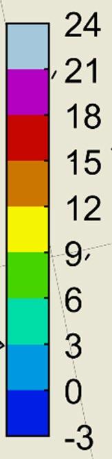
The earth’s orbit around the sun, atmospheric light refraction and the earth’s tilt and rotation are known and can be used to calculate daylight hours for any location on the planet. Using this method, a series of daylight hour plots for various latitudes are developed and given below in Figure 13. The fall equinox is indicated at the point at which daylight hours go above or below 12 hours.
 Figure 12: Sea Surface Temperature Colors used in Analysis [°C]


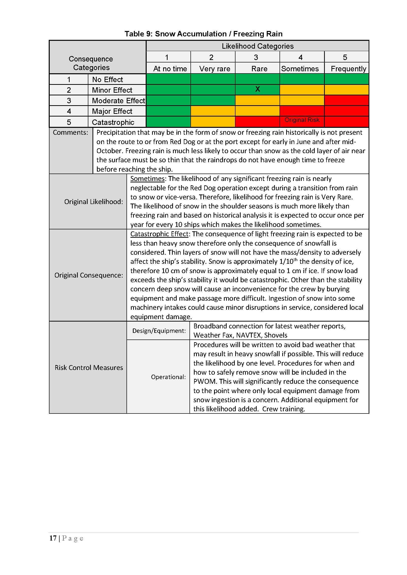


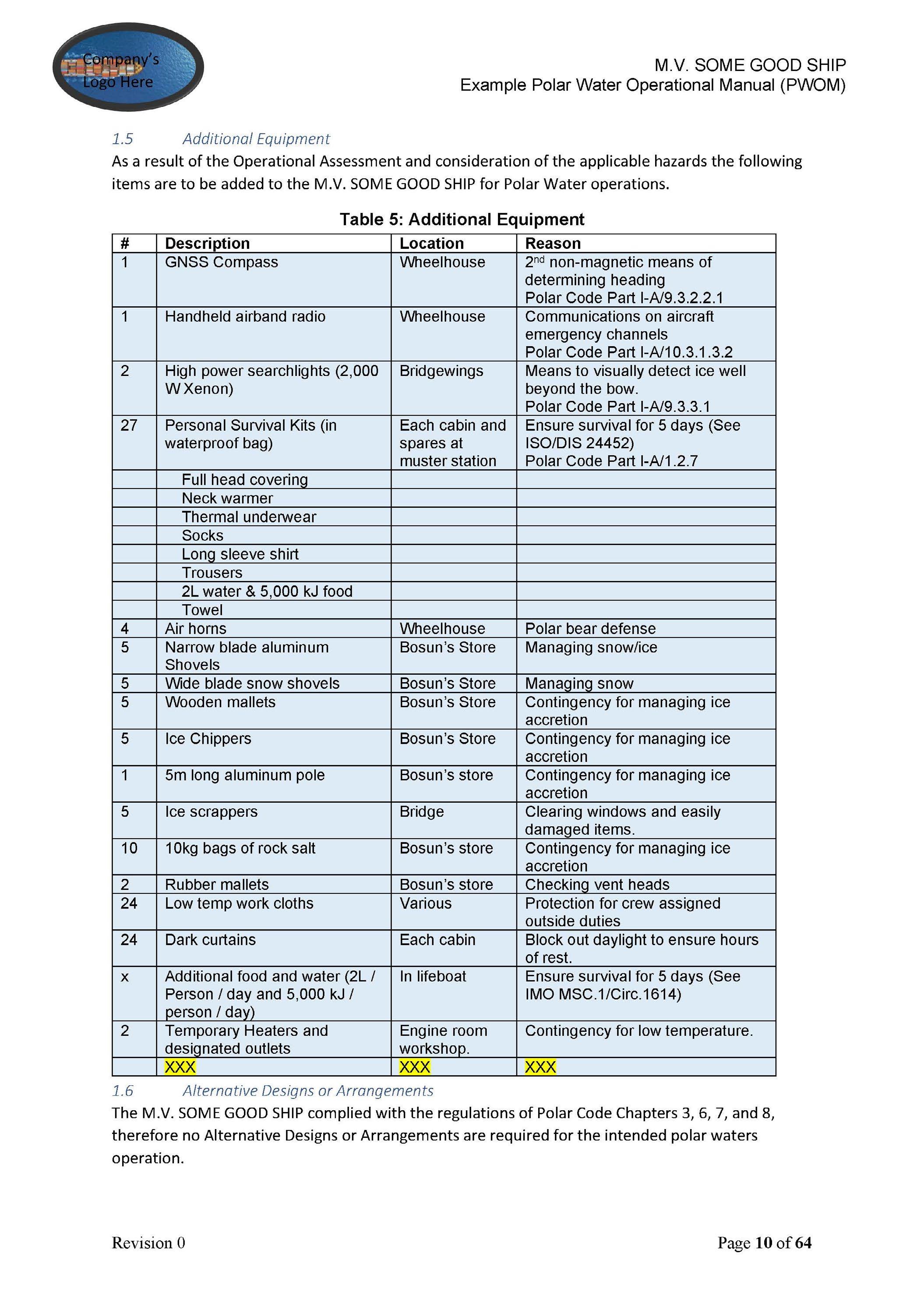


GLOBAL SUSTAINABILITY CENTER
1701 City Plaza Dr. Spring, Texas 77389, USA
Tel: +1-281-877-6000
Email: Sustainability@eagle.org
NORTH AMERICA REGION
1701 City Plaza Dr. Spring, Texas 77389, USA
Tel: +1-281-877-6000
Email: ABS-Amer@eagle.org
SOUTH AMERICA REGION
Rua Acre, nº 15 - 11º floor, Centro
Rio de Janeiro 20081-000, Brazil
Tel: +55 21 2276-3535
Email: ABSR io@eagle.org
EUROPE REGION
111 Old Broad Street
London EC2N 1AP, UK
Tel: +44-20-7247-3255
Email: ABS-Eur@eagle.org
AFRICA AND MIDDLE EAST REGION
Al Joud Center, 1st floor, Suite # 111
Sheikh Zayed Road
P.O. Box 24860, Dubai, UAE
Tel: +971 4 330 6000
Email: ABSDubai@eagle.org
GREATER CHINA REGION
World Trade Tower, 29F, Room 2906
500 Guangdong Road, Huangpu District, Shanghai, China 200000
Tel: +86 21 23270888
Email: ABSGreaterChina@eagle.org
NORTH PACIFIC REGION
11th Floor, Kyobo Life Insurance Bldg.
7, Chungjang-daero, Jung-Gu
Busan 48939, Republic of Korea
Tel: +82 51 460 4197
Email: ABSNorthPacific@eagle.org
SOUTH PACIFIC REGION
438 Alexandra Road
#08-00 Alexandra Point, Singapore 119958
Tel: +65 6276 8700
Email: ABS-Pac@eagle.org
© 2023 American Bureau of Shipping.
All rights reserved.