AVIAN BRUNKHORST
LANDSCAPE ARCHITECTURE PORTFOLIO


Adobe Creative Cloud SketchUp Software Vray Plug-in for Sketchup AutoCAD Software Land F/X Plug-in for AutoCAD Avian Brunkhorst (They/Them/Theirs) a.a.brunkhorst@gmail.com KANSAS CITY STREETCAR EXTENSION MOVE BRT SETX TRUCK PARKING PACE BUS CLEVELAND AVE METRO PARKWAY (CMAP) PRAIRIE PARK MISCELLANEOUS MODELS 1-3 4 5 6-7 8 9-11 12 Table of Contents SKILLS
The Kansas City Streetcar Extension is a continuation of the Kansas City Streetcar that currently runs along Main Street through downtown. The Main Street Extension more than doubles the existing length of the streetcar, now connecting the downtown Rivermarket district to the University of Missouri - Kansas City (UMKC). Landscape improvements were needed along much of the extension corridor. Greater emphasis was placed on the ‘final stop’ plaza at UMKC and the green infrastructure along a portion of the extension.


27 SA2 29 EP2 6 IM 10 PV 41 RH 41 SS 9 SL 5 IM 1 UP 24 EP 1 CF 881 sf FA 355 sf FA 1,537 sf FA LAWN RESTORATION 19 SL 14 LB 8 IS 13 CK E 51ST STREET NOTE: 1) SEE SHEET LS202 FOR LANDSCAPE GENERAL NOTES UMKC Plaza Landscape Plan & Landscape Schedule
RideKC Extension Map
1 Kansas City, MO | HNTB Kansas City Streetcar Extension
LANDSCAPE LEGEND:
SURFACE STONE SPLASH PAD OVER SOIL SEPARATOR
PLANT CODE AND QUANTITY NATURAL STONE WEIR SPLASH PAD WEIR STRUCTURES
SHRUBS CODE BOTANICAL / COMMON NAME AM ARONIA MELANOCARPA `MORTON` TM / IROQUOIS BEAUTY IS ITEA VIRGINICA 'SPRICH' TM / LITTLE HENRY SWEETSPIRE GRASSES CODE BOTANICAL / COMMON NAME SL SCHIZACHYRIUM SCOPARIUM / LITTLE BLUESTEM SH SPOROBOLUS HETEROLEPIS / PRAIRIE DROPSEED PERENNIALS CODE BOTANICAL / COMMON NAME CL CHASMANTHIUM LATIFOLIUM / NORTHERN SEA OATS HM HIBISCUS MOSCHEUTOS / ROSE MALLOW OS OENOTHERA SPECIOSA / MEXICAN EVENING PRIMROSE PERENNIAL AREAS CODE BOTANICAL / COMMON NAME AB2 AMSONIA X `BLUE ICE` / BLUE ICE BLUESTAR AI ASCLEPIAS INCARNATA / SWAMP MILKWEED PLANT SCHEDULE D617
STONE SPLASH PAD OVER SOIL SEPARATOR
CODE AND QUANTITY
WEIR SPLASH PAD
0' 30' 60' 15' SHRUBS CODE BOTANICAL COMMON NAME AM ARONIA MELANOCARPA `MORTON` TM IROQUOIS BEAUTY BLACK CHOKEBERRY IS ITEA VIRGINICA 'SPRICH' TM LITTLE HENRY SWEETSPIRE
CODE BOTANICAL COMMON NAME SL SCHIZACHYRIUM SCOPARIUM LITTLE BLUESTEM SH SPOROBOLUS HETEROLEPIS
DROPSEED
CODE
COMMON NAME CL CHASMANTHIUM LATIFOLIUM / NORTHERN SEA OATS HM HIBISCUS MOSCHEUTOS / ROSE MALLOW OS OENOTHERA SPECIOSA / MEXICAN EVENING PRIMROSE PERENNIAL AREAS CODE BOTANICAL COMMON NAME AB2 AMSONIA X `BLUE ICE` BLUE ICE BLUESTAR AI ASCLEPIAS INCARNATA SWAMP MILKWEED
LANDSCAPE LEGEND: SURFACE
PLANT
NATURAL STONE
WEIR STRUCTURES SCALE: 1"=30'
GRASSES
PRAIRIE
PERENNIALS
BOTANICAL
PLANT SCHEDULE D617
0' 30' 60' 15' Memorial Stop Green Infrastructure Plan & Landscape Schedule RideKC Extension Map 2 Kansas City Streetcar Extension Kansas City, MO | HNTB
SCALE: 1"=30'

89 SY FA 1,115 LB 6 SY FA 6 SY FA 609 LB 465 SY FA 375 SY FA 92 SY FA 27 SY FA 28 SY FA 189 SY FA 46 LB 46 LB 46 LB 46 LB 690 LB 932 LB 635 LB 1,072 LB 90 LB 19 VM 17 IS 9 AM 10 IS 19 IS 10 VM 9 AM 8 PS2 1 ZS 1 ZS 9 IS 9 IS 21 CG 239 SY FA 67 LB 5 HA 5 HA 36 SY FA 4 ZS SCALE: 1"=60' 0' 60' 120' 30' 89 SY FA 1,115 LB 6 SY FA 6 SY FA 375 SY FA 92 SY FA 27 SY FA 28 SY FA 189 SY FA 46 LB 46 LB 46 LB 46 LB 690 LB 932 LB 635 LB 1,072 LB 90 LB 19 VM 17 IS 9 AM 10 IS 19 IS 10 VM 9 AM 8 PS2 1 ZS 1 ZS 9 IS 9 IS 21 CG 239 SY FA 67 LB 5 HA 5 HA 36 SY FA 4 ZS SCALE: 1"=60' 0' 60' 120' 30' Kansas City Streetcar Riverfront Extension - Planting Plan & Landscape Schedule RideKC Extension Map 3 Kansas City, MO | HNTB Kansas City Streetcar Extension


MoveBRT will implement a Bus Rapid Transit (BRT) system along a 10-mile corridor that connects Lousiana State University (LSU) to downtown Baton Rouge. Additonally, this project included the design and development of a parkand-ride North Transfer Center. Project responsibilities included development of intial renderings for select locations and creation of low-maintenance landscape plans that incorporated elements of green infrastructure, such as permeable paving.
MoveBRT Permeable Paving Detail
Plans 4 MoveBRT HNTB | Baton Rouge, LA
MoveBRT North Transfer Center Landscape
SETX Truck Parking was a submission for a RAISE Grant in Texas. These submission focused on redeveloping existing truck parking sites across the state in order to increase truck driver safety. Project responsibilities included developing conceptual plans for multiple sites across the Southeast Texas region, including Port Freeport and Angleton. These sites required EV charging for both trucks and cars, trurning radii of trucks, bioswales for site flooding, and a trail system connecting to the larger sidewalk system.


80.00' 30.00' R60.00' 15.00'TYP. 9.00' TYP. 6.01' TRUCK PARKING (23 SPACES) PINE ST. / FM 1495 UNION PACIFIC UNIONPACIFIC EXISTING TRANSMISSION POLE SECURITY / RESTROOM FACILITY CONNECTION TO SIDEWALK NETWORK CONNECTION TO SIDEWALK NETWORK TRUCKPARALLELPARKING (4SPACES) TRUCK PARALLEL PARKING (2 SPACES) TRUCKPARALLELPARKING (1SPACE) LIGHTING, TYP. BIOSWALE ELECTRIC VEHICLE CHARGING (4 SPACES) EV CHARGING STALLS (2 SPACES) VEHICLE PARKING (1 SPACE) February 2, 2024 SOUTHEAST TEXAS REGION SCALE: 1"=1' 0' 1' 2' 0.5' NORTH SCALE: 1"=5' 0' 2.5' SCALE: 1"=2' 0' 2' 4' 1' SCALE: 1"=10' 0' 10' 20' 5' SCALE: 1"=30' 0' 15' SCALE: 1"=20' 0' 20' 40' 10' SCALE: 1"=40' 0' 40' 80' 20' SCALE: 1"=60' 0' 30' SCALE: 1"=50' 0' 50' 100' 25' SCALE: 1"=80' 0' 80' 160' 40' SCALE: 1"=150' 0' 75' SCALE: 1"=100' 0' 100' 200' 50' SCALE: 1"=200' 0' 200' 400' 100' SCALE: 1"=400' 0' 200' SCALE: 1"=300' 0' 300' 600' 150' SCALE: 1"=500' 0' 500' 1000' 250' SCALE: 1"=600' 0' 600' 300' NORTH NORTH NORTH NORTH NORTH
FACILITY PLAN SCALE: 1"=1' 0' 1' 2' 0.5' SCALE: 1"=5' 0' 5' 10' 2.5' SCALE: 1"=2' 0' 2' 4' 1' SCALE: 1"=10' 0' 10' 20' 5' SCALE: 1"=30' 0' 30' 60' 15' SCALE: 1"=20' 0' 20' 40' 10' SCALE: 1"=40' 0' 40' 80' 20' SCALE: 1"=60' 0' 60' 120' 30' SCALE: 1"=50' 0' 50' 100' 25' SCALE: 1"=80' 0' 80' 160' 40' SCALE: 1"=150' 0' 150' 300' 75' SCALE: 1"=100' 0' 100' 200' 50' SCALE: 1"=200' 0' 200' 400' 100' SCALE: 1"=400' 0' 400' 800' 200' SCALE: 1"=300' 0' 300' 600' 150'
RAISE GRANT: PORT FREEPORT TRUCK PARKING
Angleton Conceptual Rendered Plan
Port Freeport Conceptual Rendered Plan
5 Southeast TX | HNTB SETX Truck Parking
Port Freeport Truck Clearance


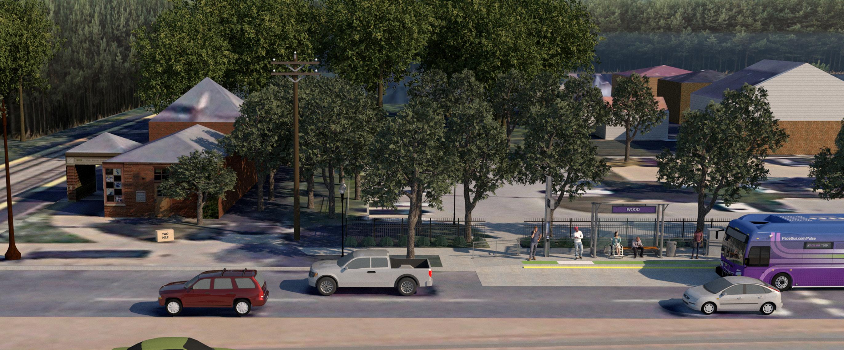
PACE is an ongoing effort to advance suburban BRT service in the Greater Chicago area. An analysis was done to determine which stations needed to be replaced completely and which could be adapted to work along with PACE.
The main project responsibility was to graphically model the new PACE bus and station in existing conditions, either adding onto or replacing older infrastructure that was not adequately serving the surrounding community. These renderings were shared with the plannning team and clients to ensure the preservation of historical or important landmarks, determine new station locations, and assess the feeling of safety the changes could create.
 Existing Conditions, PACE Bus West Bound Wood
6 PACE Bus HNTB | Chicago, IL
Proposed Station, PACE Bus West Bound Wood Station Lighting Study

PACE Bus - Halsted & 95th Night Rendering 7 Chicago, IL | HNTB PACE Bus

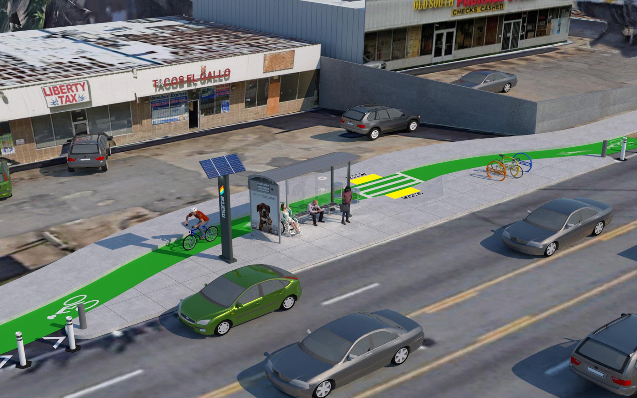
Cleveland Metro Avenue Parkway (CMAP) began as an effort to showcase the different transit opportunities available in the Greater Chicago Area. This graphic also demonstrated the differnet ways that these transit systems (Pedetrian, Bus, and Train) could all intersect with each other. Project responsibilities were to create all intial 3D reference model and subsequent photo-match renderings intended to highlight specific intersections of these transit systems.


 3rd Avenue Floating Bus Station with Protected Bike Lane
Conceptual Transit Diagram
East Point Train Station with Integrated Matra Stop
Pedestrian and Bus
3rd Avenue Floating Bus Station with Protected Bike Lane
Conceptual Transit Diagram
East Point Train Station with Integrated Matra Stop
Pedestrian and Bus
8 CMAP HNTB | Chicago, IL
Bus and Train
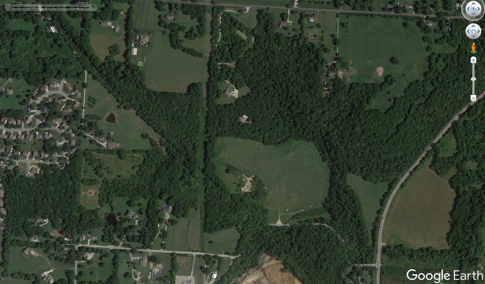
Prairie Park is located along the Rock Island Trail. The inclusion of the park along the trail will provide much-needed green space to Raytown, which is a historically-underserved area southeast of Kansas City, MO. Prairie Park is divided into an upper and lower area, with tall prairie grass restoration along the north side connecting the two. A series of ramps allows trail users to access either the upper or lower area. The upper area has a Boxcar Bench, short prairie grass restoration, and educational plaques framing the scenic, natural views. The lower area is more of a gathering space, hosting more Boxcar Benches and ample picnic benches. The plant palette for short and tall grasses focuses on prairie restoration and native species, which creates visual interest and learning opportunities for visitors.


0 1 5 km Woodson Road Trailhead Truman Sports Complex Rock Island Trail Phase 1 Rock Island Trail Phase 2 Greenway Floodplains Park Raytown Zoning Border Inverted 0 200 400 Prairie Boxcar 900 920 Rock Island Inverted Mound 800 Prairie Park Boxcar Benches 1 Foot Contour Rock Island Trail Phase 2 1200 ft. 800 900 820 920 Rock Island Trail Phase 2 Inverted Mound 0 1200 ft. 200 800 400 Prairie Park Boxcar Benches 1 Foot Contour
Raytown Green Space Zoning
Illustrative Plan
Prarie Park Context Map
9
University of Oregon Prairie Park
Raytown, MO |


0 Trail 20 100 Feet Prairie Park Extent 40 60 80 10 ft. Contours 1 ft. Contours Tall Prairie Grass Restoration Designated Viewing Area Short Prairie Grass Restoration Existing Trees Designated Gathering Space Gravel Pathway Picnic Benches Boxcar Benches Trash Cans Educational Plaques Entrace Ramp Trashcan Picnic Bench Boxcar Bench Industrial Artifact Educational Plaques Boxcar Bench Trashcan Entrance Ramp Big Blue S em | Andropogon geradii Spring Summer Fall Winter Big Blue Stem Andropogon geradii 4’-6’ Little Blue Stem Schizachyrium scoparium 2’-4’ Common Milkweed Asclepias syriaca | 2’-3’ Switchgrass Panicum virgatum 3’-6’ Ashy Sunflower Helianthos mollis 2’-4’ Prairie Blazing Star | Liatris pycnostachya 2’-5’ Canada Wild Rye Elymus canadensis | 2’-5’ Wood Grass | Sorghastrum nutans | 3’-5’ Beardtongue Penstemon digitalis 3’-5’ Pale Purple Coneflower | Echinacea pallida 1’-3’ Prairie Dropseed | Sporobolus heterolepis | 1’-3’ Programming Plan Seasonal Plant Palette Tall Prairie Grass Restoration Upper Park Plan Lower Park Plan 10 Prairie Park University of Oregon | Raytown, MO

 Boxcar Detail
Bench Detail
Upper Prairie Park Render
Boxcar Detail
Bench Detail
Upper Prairie Park Render
11
Lower Prairie Park Render
Raytown, MO | University of Oregon Prairie Park


AVIAN BRUNKHORST a.a.brunkhorst@gmail.com
