ALEXISARIAS BETANCOURT
SELECTED WORKS - 2023
PORTFOLIO
CONTENTS
1. R | B VILLA
PRIVATE PROJECT - MANGAHUANTAG
QUITO | ECUADOR | BUILT | 2015
2. FACTORY IN A PARK
ARCH STUDIO IV - GRADUATE SCHOOL
CHICAGO | 2019
3. ESTANCIAS DEL AGUA
ARCHITECTURE AND LANDSCAPE LAB
RCR LAB | OLOT | 2017
4. THE DRIVERLESS CITY
RESEARCH ASSISTANT
CHICAGO | IIT | 2022
5. TRANSITIONAL ECOLOGIES
CLOUD STUDIO I - GRADUATE SCHOOL
CHICAGO | IIT | 2020 1 2 3 4 5
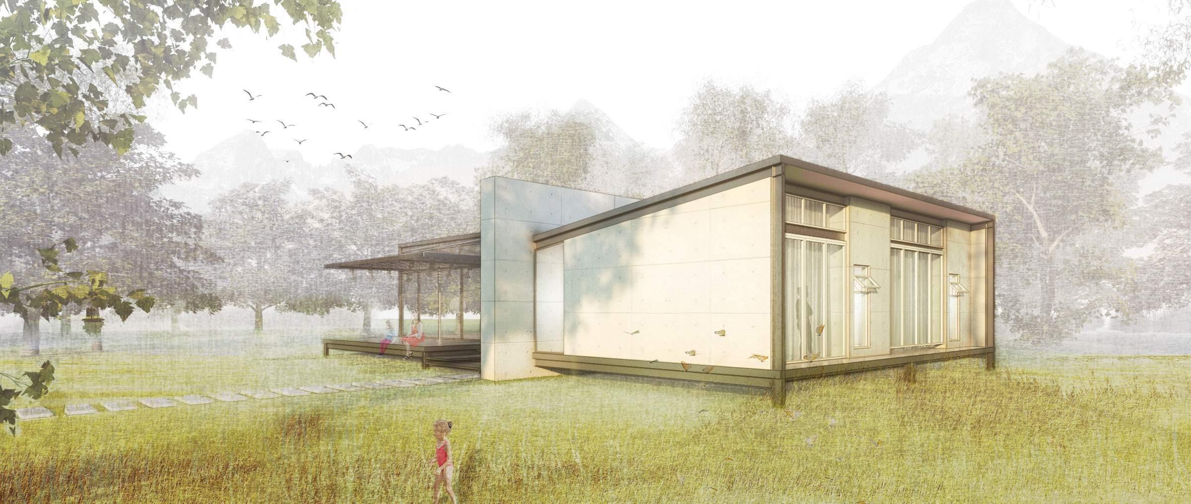
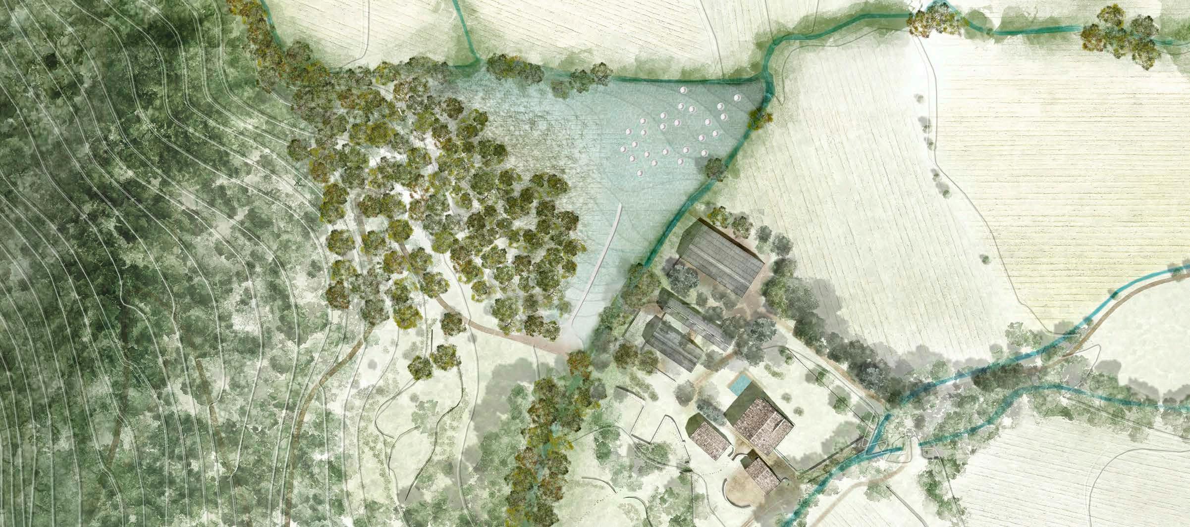
R | B VILLA
VACATIONAL HOME FOR A NEWLY GRANDMOTHER
PRIVATE PROJECT - MANGAHUANTAG | QUITO | ECUADOR | BUILT | 2015
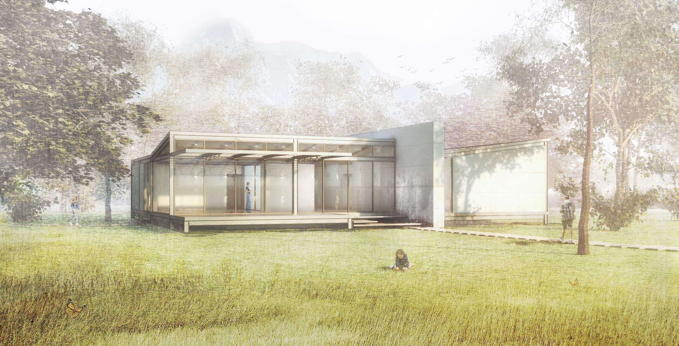
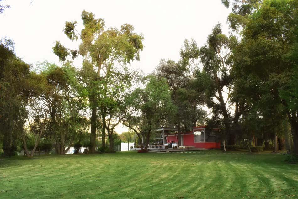
Located in Mangahuantag, a small suburb in the city of Quito, a space is proposed as a vacational hide-out for a small family.
The client’s vision for the project is to be a place of gathering, of social meetings, and also a place to share with her children and future grandchildren. This gave a guideline of the programmatic needs of the user.
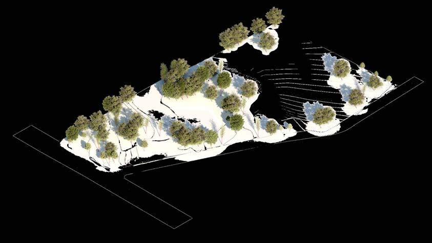
The site has unique nature features. It possess- es a unique and exotic vegetation with patrimonial trees like Ceibos and American Pines. Given this, the first decision on the project is not to tear down any of the existent trees, plan the house around this diverse and exotic, micro-landscape, and also to provide a central prairie for random activities.
NORTH VIEW
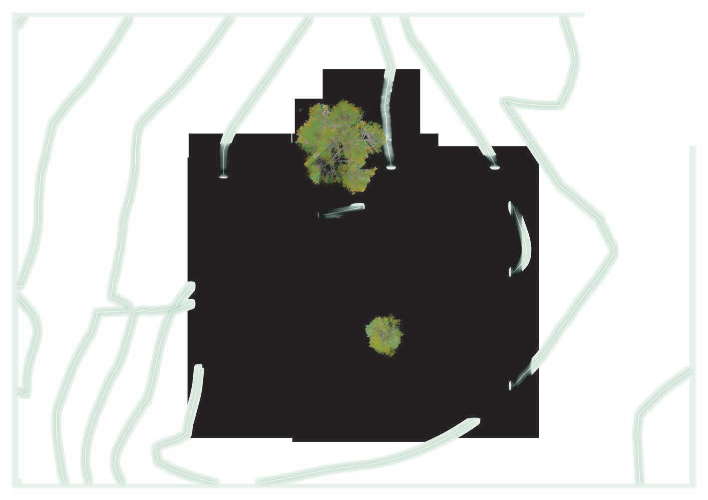
ZONING
Farming Area
Sloped Garden
Central court
Quincho site
House site
Private Garden
TOPOGRAPHY
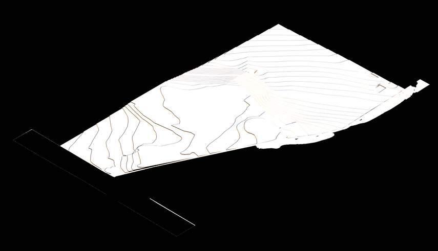
The highest elevation was designated for the Quincho, the lower zone is for farming, and the middle point has been selectd for the house.
The highest elevation was designated for the Quincho, the lower zone is for farming, while middle point has been selected for the main house.
The topography of the place suggests that the central architectural element has to be placed in the middle area of the land. However, the proposal prioritizes the landscape and green spaces. The area with a medium slope to the west has been dedicated to the house, and the area with a steeper hill to the east has been designated for crops. In contrast, the prairie area was designated for spontaneous events and the playground.
MAIN ENTRANCE H.P L.P MAIN ENTRANCE H.P L.P
SITE
NE AERIAL VIEW
HOUSE QUINCHO
SITE PLAN 1/128”=1’-00”
PROGRAM INTERPRETATION
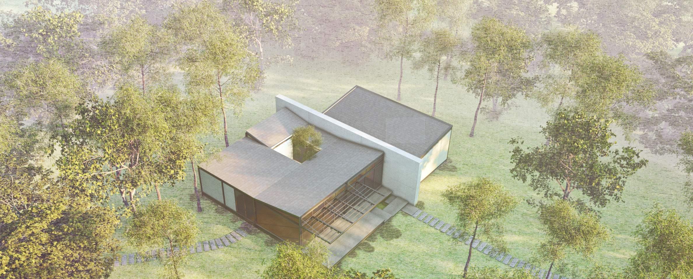
The program requirements suggested a linear typology in which the relations between spac es were connected sequentially. It required two well-identified areas, private and public. However, the physical conditions of the land and the desire to conserve all existent trees suggested the modification of the linear ty pology to fit in the proposed site of the prop erty while keeping the spatial configurations.
GROUND FLOOR 1/16”=1’-00”
BEDROOM1 PRIVATE PUBLIC BEDROOM CLOSET BATHROOM BEDROOM LIVING ROOM DINING KITCHEN PANTRY LAUNDRY STORAGE CLOSET BATHROOM W.C BEDROOM2 LIVING ROOM DINING ROOM KITCHEN PRIVATE PUBLIC BEDROOM LIVIND ROOM DINING KITCHEN PANTRY LAUNDRY STORAGE CLOSET BATHROOM BEDROOM CLOSET BATHROOM W.C
MASTER BEDROOM W.C KITCHEN ENTRANCE HALL BEDROOM PANTRY LAUNDRY STORAGE TERRACE DINING LIVING CLOSET CLOSET
NW VIEW
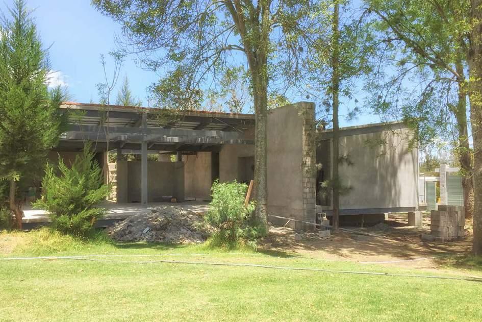
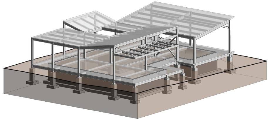
Construction planning and management were included in the contract. The project was planned to be completed in a period of 10 months, 2 of these dedicated to design, 1 to planning work and engineerings, and the rest of the time to the construction and adequation of the landscape. With the vision of streamlining the construction process, a metal structure was adopted as
a construction system, which was modulated and prefabricated to be assembled on site.
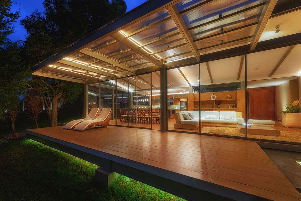
As a final result, it was possible to deliver an integral project between the landscape and the architectural element. By prioritizing the landscape, it was possible to frame views and scenarios of the site and enhance the importance of nature on the site.
NORTH ELEVATION 1/16”=1’-00”
CENTRAL PRAIRIE
HAMMOCK DECK
CONSTRUCTION PROCESS
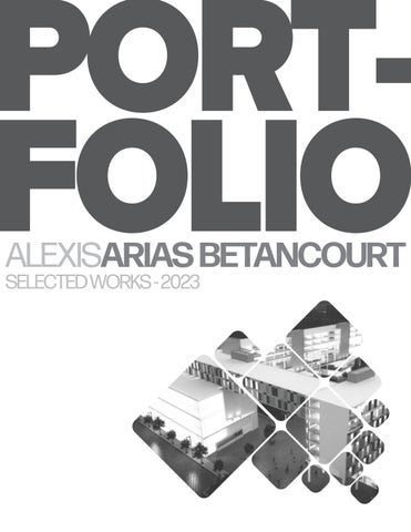
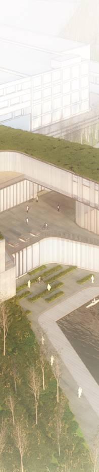
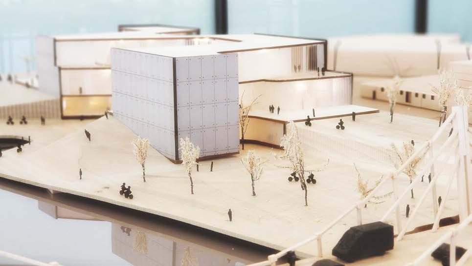
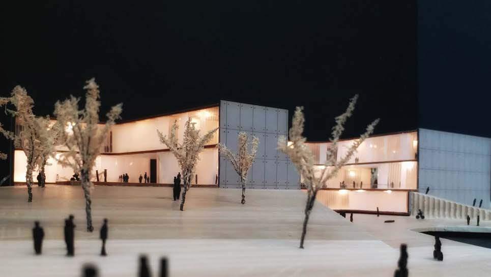
FACTORY IN A PARK
MANUFACTURING CYCLISM COMMUNITY
ARCH STUDIO IV - GRADUATE SCHOOL | IIT | CHICAGO | 2019
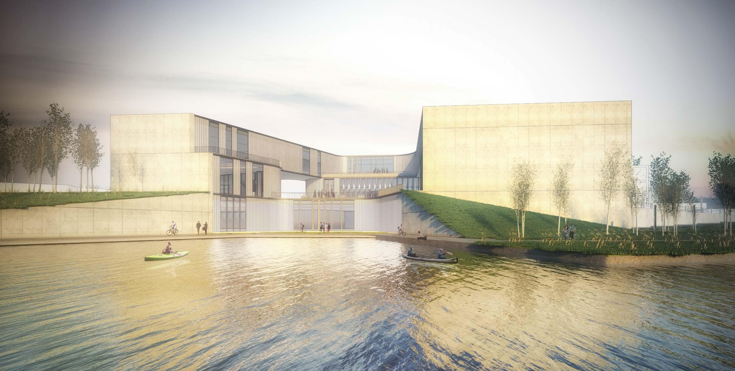
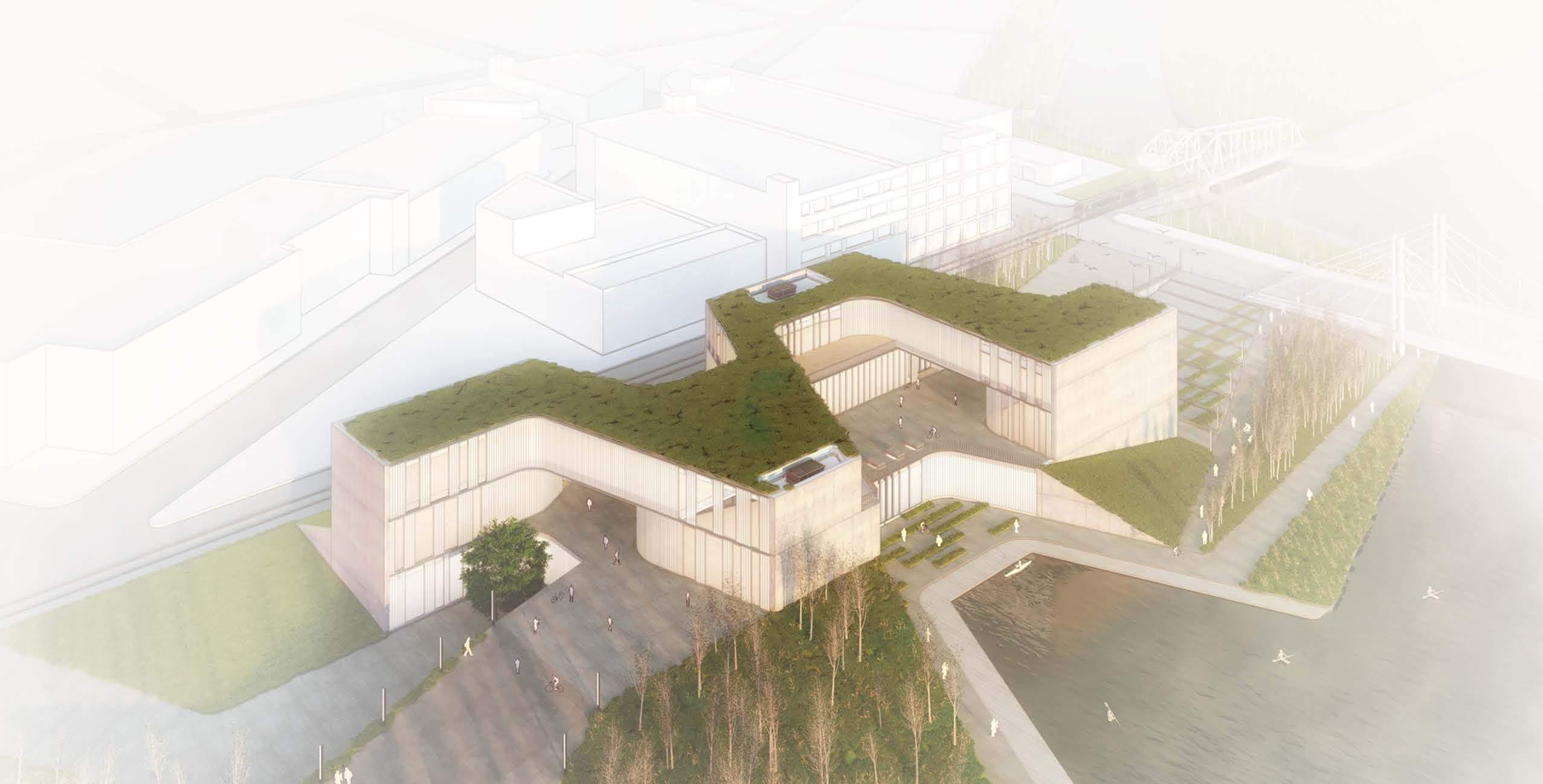
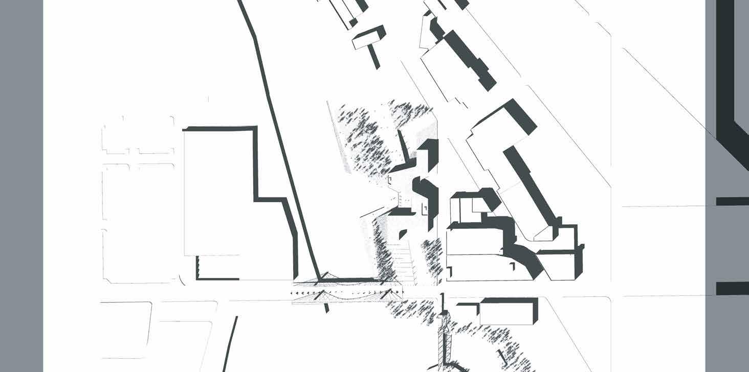
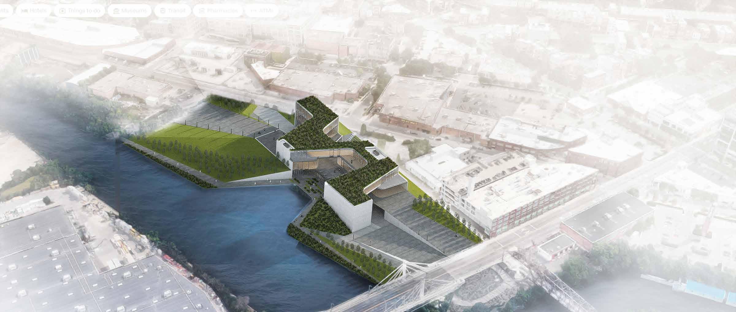
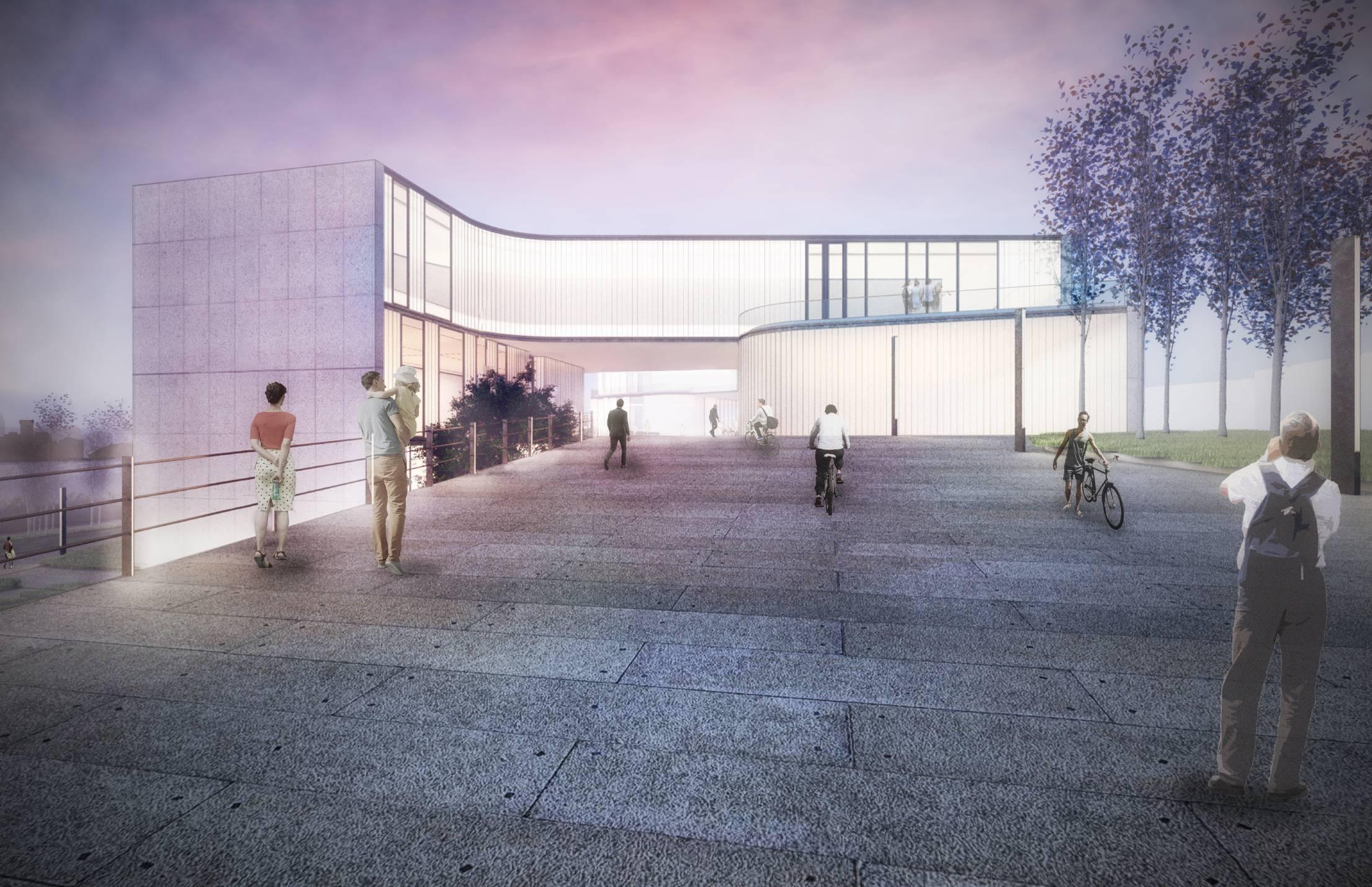
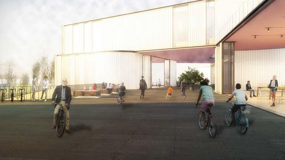
Located in the Chicago River edge in Goose Island, an abandoned site, currently a scrapyard, is proposed as the place for an urban bicycle manufacturing center.
The project aims not only to host industrial activities but also to be a social catalyst in the neighborhood, promoting bicycle culture in the city, and providing a safe passage for pedestrians
through this area.
This public-private intervention will not only help in revitalizing the neighborhood by opening the site for recreational spaces but will also provide new connections to the city.
The design communicates the idea of continuous connection by “stitching” the urban fabric in a structured and choreographed environment.
WEST VIEW
Created in 1850s, Goose Island was an essential component of the industrial corridor along the Chicago River. But with the transformation of its adjacencies (Lincoln Park), the island lost its identity as a manufacturing district, leaving remnants of its former operations and causing disruptions in the neighborhood and its continuity. With new development happening like Lincoln Yards, it is natural that sites like this need to go under an intensive
transformation, and being transformed into socio-economical corridors, mainly being located at the edge of the river. Therefore the proposal aims to create a passage between the city and the Chicago River, stitching them together to the urban fabric. The transformation of a scrapyard into a cultural hub was proposed. The architectural gesture responds to the adjacent context by providing sights and passage to the main places of the area.
URBAN SUTURE SOCIAL EROSION
NW AERIAL VIEW


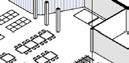


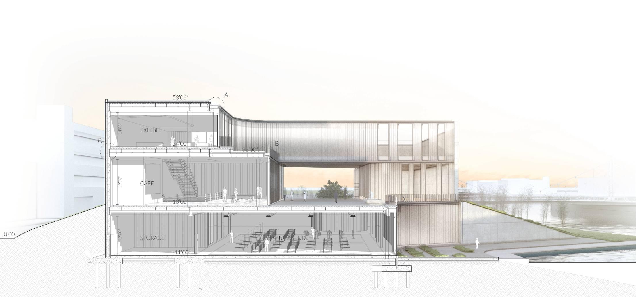
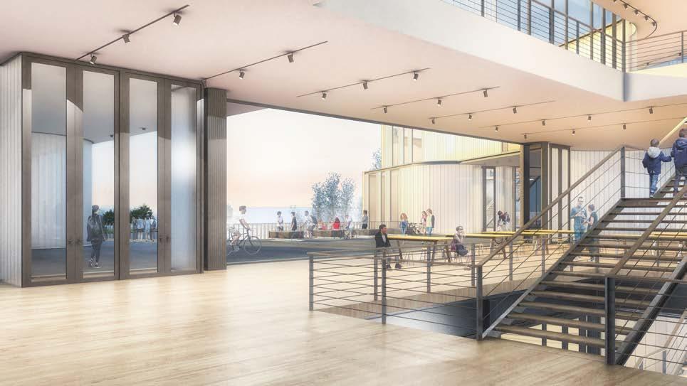
UP OFFICE EXHIBIT ENTRANCE BAR COFFEE BIKE SHOP MULTI USE SPACE Chicago River SITE PLAN 1/50”=1’-00” 1 P 2 P 3 P 4 P 5 P 6 P 7 P PROGRAM Exploded Axon ROOFTOP +53’06” 1 E 1 P 2 P 3 P 1 F 10 F 2 F 11 F 15 F 3 F 12 F 4 F 13 F 5 F 14 F 6 F 7 F 8 F 9 F 4 P 5 P 6 P 7 P 2 E 3 E 4 E 5 E EXHIBIT LEVEL +34’00” 1E Entrance for exhibition 2E Temporary exhibition 3E Bridge - Gallery lookout 4E Permanent Exhibition 5E Exit - Bike shop 6E Balcony PLAZA LEVEL +10’00” 1P Drop off 2P Public Plaza 3P Office 4P Entry Galleria 5P Cafeteria 6P Bike shop 7P Seasonal Market 8P Rolling Heel FACTORY LEVEL -11’00” 1F Service Enrtry 2F Office & Lockers 3F Cargo Entry 4F Loading/Unloading 5F Storage 6F Paint + Manufacture 7F Assemble 8F Clean + Boxing 9F Store box 10F Laboratories 11 F Entry court 12F River court 13F Bike parking and service 14F MEP room 15F Visitors entry 16F Kayak Dock
Program: To re-develop an inner-urban bicycle manufacturing center on a long abandoned site on the Chicago River edge in Goose Island. The proposed manufacturing unit will provide open access to general public at large to understand the process of bike production along with formal and informal exhibition spaces on clean and well maintained landscaped spaces. This public-private intervention will not only help in re-vitalizing the neighborhood by opening the site for recreational spaces but will also provide a new platform for bicycle community of Chicago.


NORTH AVENUE BRIDGE
GROUND FLOOR
NKINGSBURY ST.
1- Concrete Tiles
2- 1” Glass railing
3- 9” U Section Steel
4- Insulation
5- Aluminum receiver profile
6- Waterproof membrane
7- Railing Channel
8- W Section Beams
9- W Section Girder
10- W Section Column
11- 9” Steel Square Tube
12- Pin Connection
13- Fiber Cement Board
14- Protection Board
15- Pedestal Pavers
Balcony Detail
1 2 3 4 5 6 7 8 9 10 11 12 13 14 15
Roof Detail 1- Green Roof 2- Planting Soil 3- 1/2” Separation Layer 4- 1” Drainage Mat 5- 2” Waterproof Membrane 6- 3” Insulation 7- 6” Composite Deck 8- 2.5” Steel Tube 9- W Section Steel Girder 9” Steel Tube 10- 9” U Section 11- Flushing 12- Vent 13- Parapet 14- W Section Steel Beams 15- Plaster Ceiling 16- 1” Clear Glass 17- 12” X 3” Channel Glass 18- Return Air Cavity 19- 6” X 3” Aluminum Tube 20- Aluminum Receiver Profile
1 3 4 5 7 9 10 11 12 13 14 15 16 17 18 19 20 SECTION WALL
Strategy: “Concatenation”- to have series of unexpected experiences through the site while stitching the connections between the existing fabric to the 606 bike trail. The orchestrated programmatic interventions create multiple pauses for the pedestrians and bikers to host social activities therefore, create focal points for interactive gathering spaces across the site. The strategy is also
to sandwich public spaces between the private manufacturing unit and a semi-public exhibition spaces for bicycle community. These multi-level programs sew the link between both, the vertical and horizontal elements in the building. Architectural Expression: The design communicates the idea of continuous connection by “stitching” the urban fabric in a structured and choreographed.
 South Entrance
 GROUND FLOOR PLAZA
GALLERY ENTRANCE AND CAFETERIA
NORHT WEST VIEW
SOUTH WEST VIEW
GROUND FLOOR PLAZA
GALLERY ENTRANCE AND CAFETERIA
NORHT WEST VIEW
SOUTH WEST VIEW
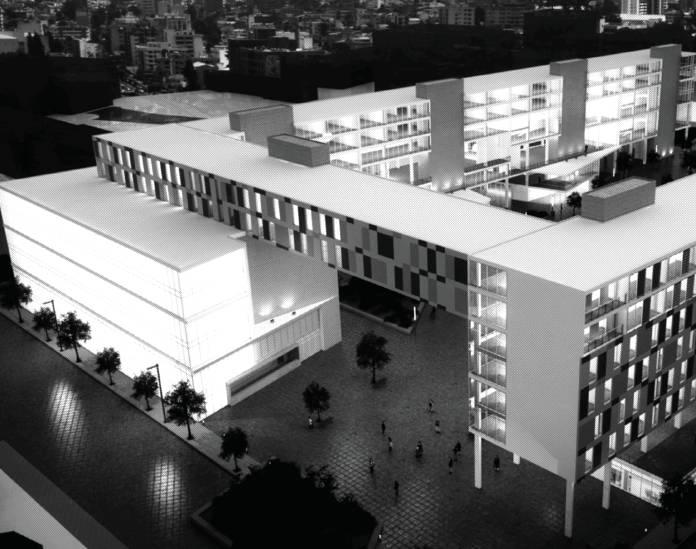
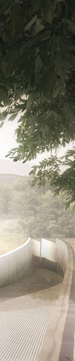
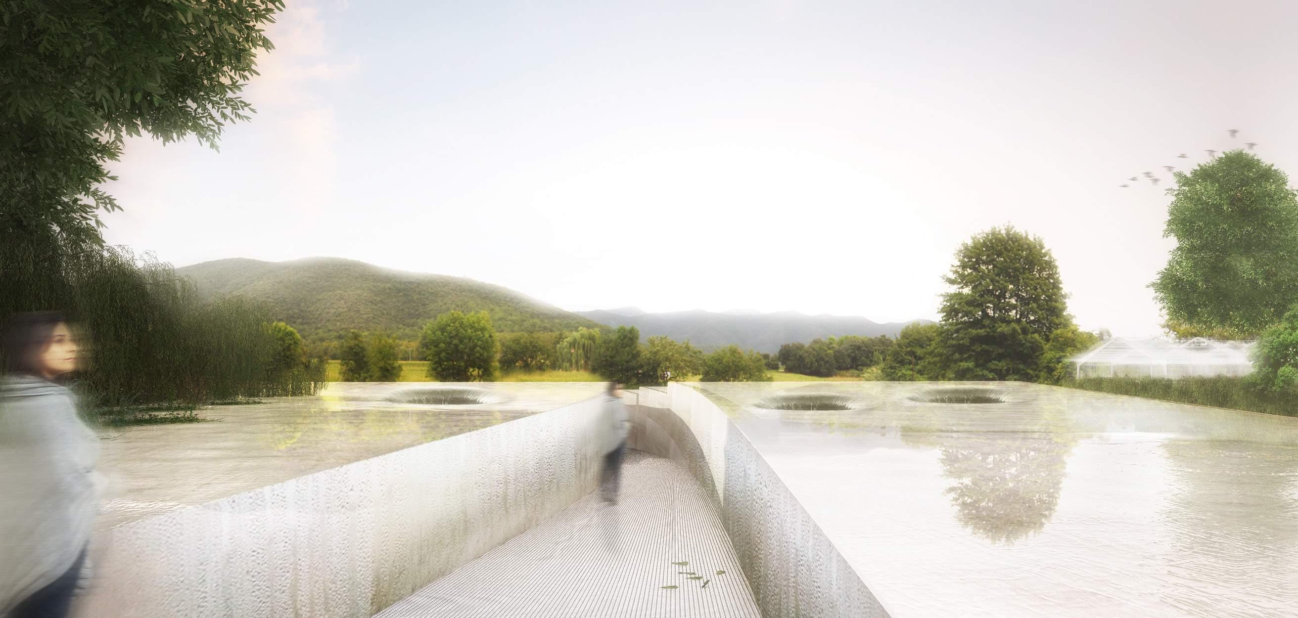
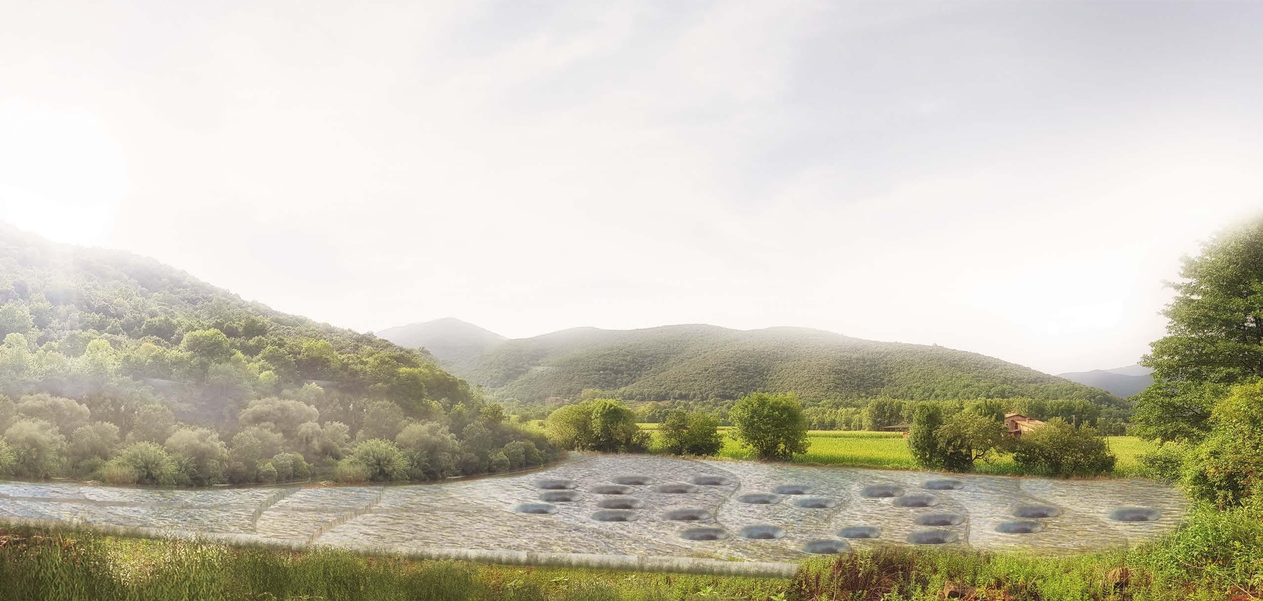
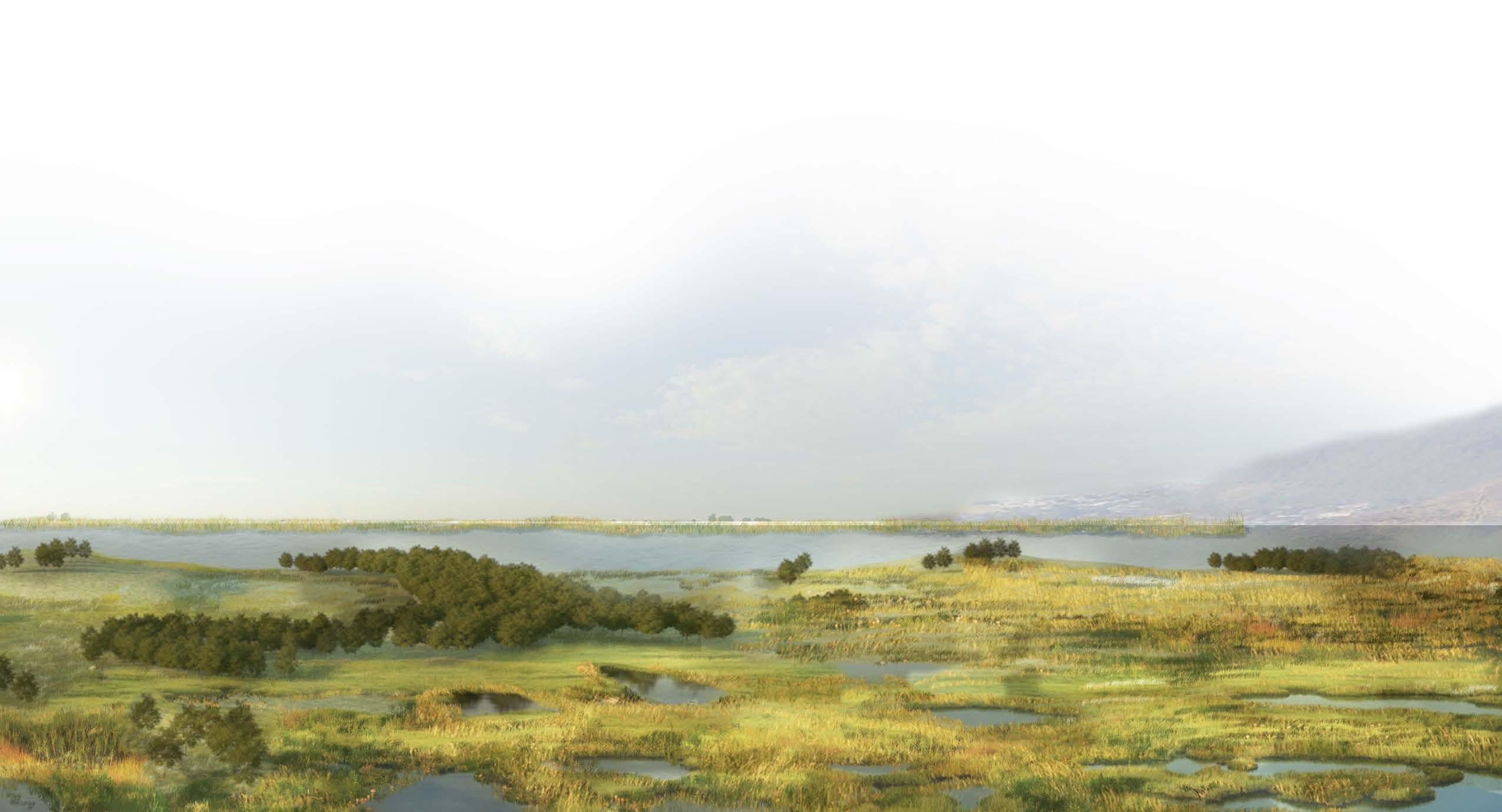
ESTANCIAS DEL AGUA
WATER AS A CREATIVE EXPERIENCE
ARCHITECTURE AND LANDSCAPE LAB | RCR LAB·A | OLOT | 2017
Having won the Pritzker Prize in 2017, RCR Arquitectes used this prestigious recognition as a platform to expand its operations into other fields. Among his imaginative proposals, they began with the planning of the “geography of dreams”. A space located in Sant Pere Despuig, in Girona, Spain, whose purpose is the imaginative exploration of its visitors. This space consists of a hotel and quarters based on phenom -
enological experiences, in addition to the “university of dreams.” Among these rooms, “the water chambers” are proposed, which propose water not as a tangible and physical resource, but as an articulating element of artistic discourse. Due to its ethereal quality, immateriality and physicality, water is picked as a guide in a ceremony of creation, introspection, and purification.
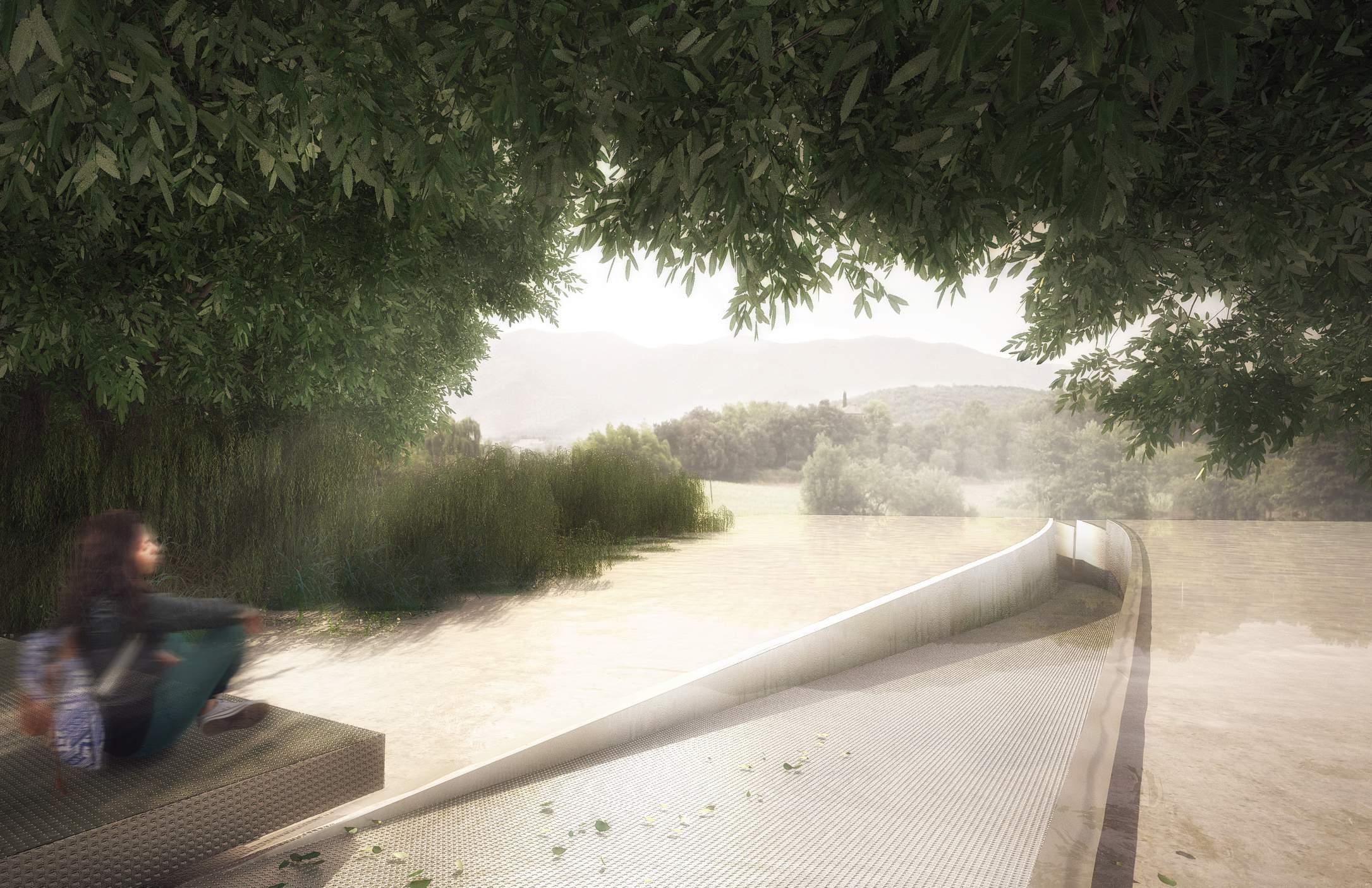
ACCESS VIEW
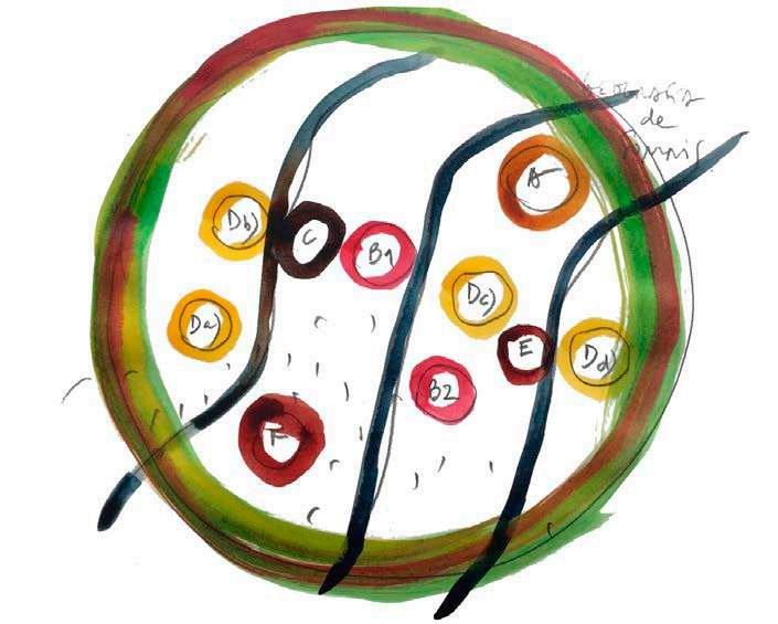
NARRATIVE JOURNEY FILTER ACCESS ACCUMULATION CELL IMMERSION JOURNEY VIEW
GEOGRAPHY OF DREAMS WATER AS
SITE PLAN 1”=120’-00” Water Pods Water Pods Estancias del agua University of dreams University of dreams Access Journey Hotel of dreams Access Geography of dreams SECTION 1”=60’-00”
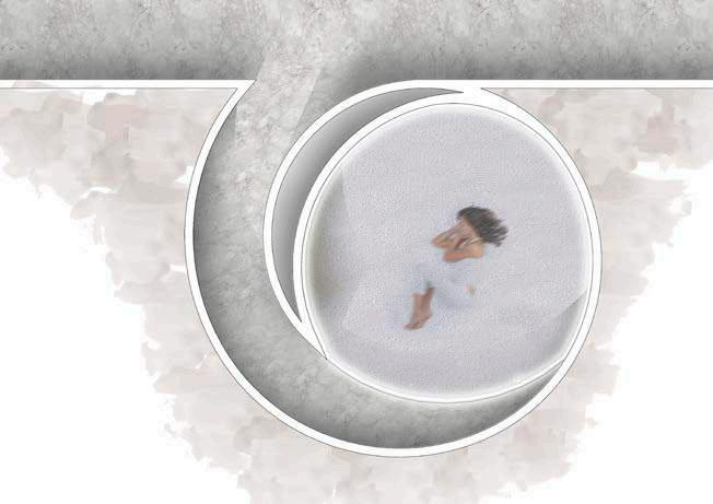
Water is used as the guidance system to navigate through the project. It is focused on 3 particular moments. Access or acumulation is the moment where the water gets collected from the neighboring highlands. It is the beginning of the ritual.
The Journey begins by understanding how gravity will move water across the site, it is intended as the cleansing part of the ritual. It creates a corridor that takes you underground where the meditation pods are located.
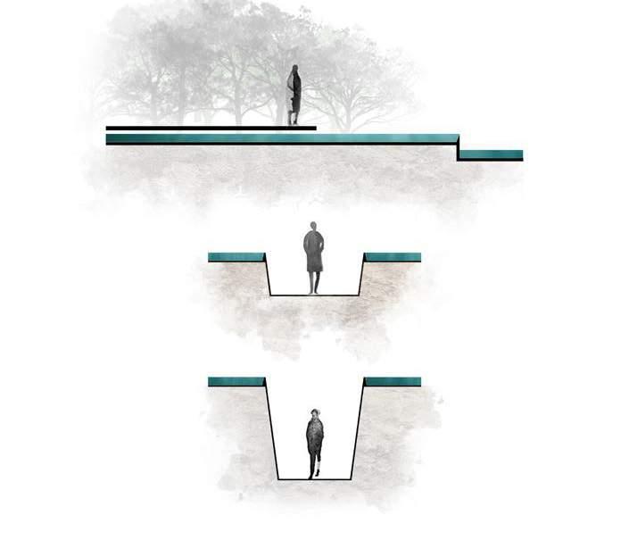
At the end of the journey meditation pods, are proposed, They are conceived as spaces for reflection, planned to be individual pods in which their users are forced to disconnect from the world and immerse themselves in ideas and creativity.
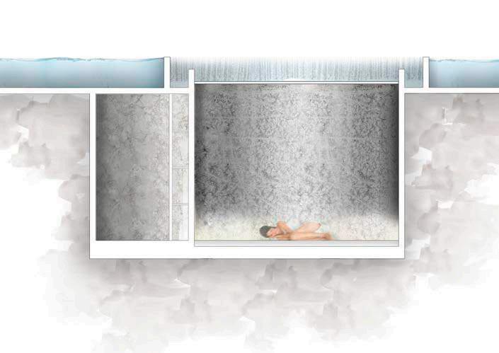
IMMERSION
SECTION 1”=60’-00”
ACCESS ACUMULATION
CELL JOURNEY FILTER

SPIRAL AS VOID GENERATOR STATIC NO DIRECTION NO ORIENTATION ROOF VERTICAL RELATIONSHIP MEDITATION PODS ESTANCIAS DEL AGUA - SOUTH VIEW
It is intended, through the initial idea of developing a set of 25 rooms in the physical area of a triangular -shaped portion of the agricultural field, having on two of its sides a riverbank, to enable an experience of living in a framework determined by the link with water, understood as matter and material, with the symbolic and mythological charge attributed to it, as well as with its value as an articulating element of the landscape.
Understanding in this act of “colonization” (sowing, tilling), the possibility of establishing a narrative discourse that is linked to the experience that the place proposes, understood as a set of pieces in the landscape that read, observe, explain, articulate, complement, sew, frame, signify.
It is, therefore, the possibility of highlighting and amplifying the natural conditions of that portion of the field
characterized by the perimeter stream, through the experience of inhabiting a new landscape, a landscape of water. The purpose of the project is to understand the place, time, and action as mechanisms to articulate an architectural-landscape discourse that emphasizes sensitivity to inhabitant’s worldview.
The units are narrated as “refuge”, that is to say, a shelter space, of physical protection in a natural environment already domesticated. The aim is to achieve areas that, through silence, allow us to live intensely calm, physical, and spiritual, using the mechanisms that the relationship with water, in this specific place, can provide us. These Cells are proposed as a mechanism to recover the essence of water and its nature in your room, besides enhancing the relationship between the natural and the spiritual.
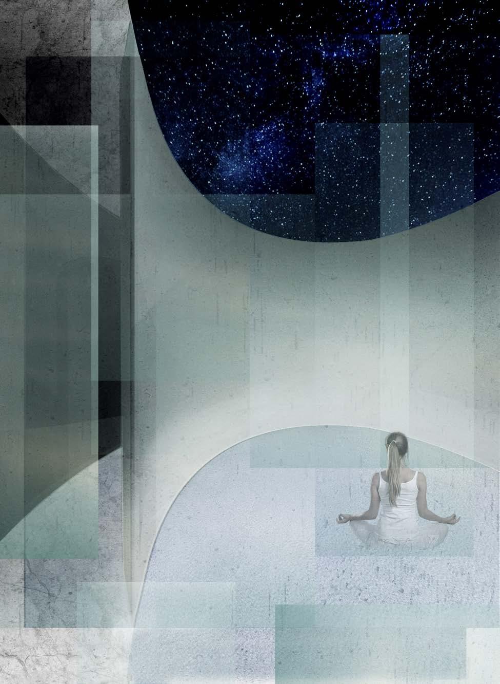
MEDITATION POD ESTANCIAS DEL AGUA
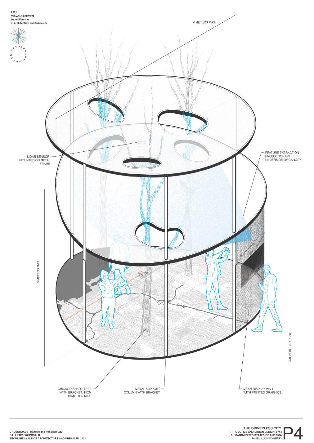
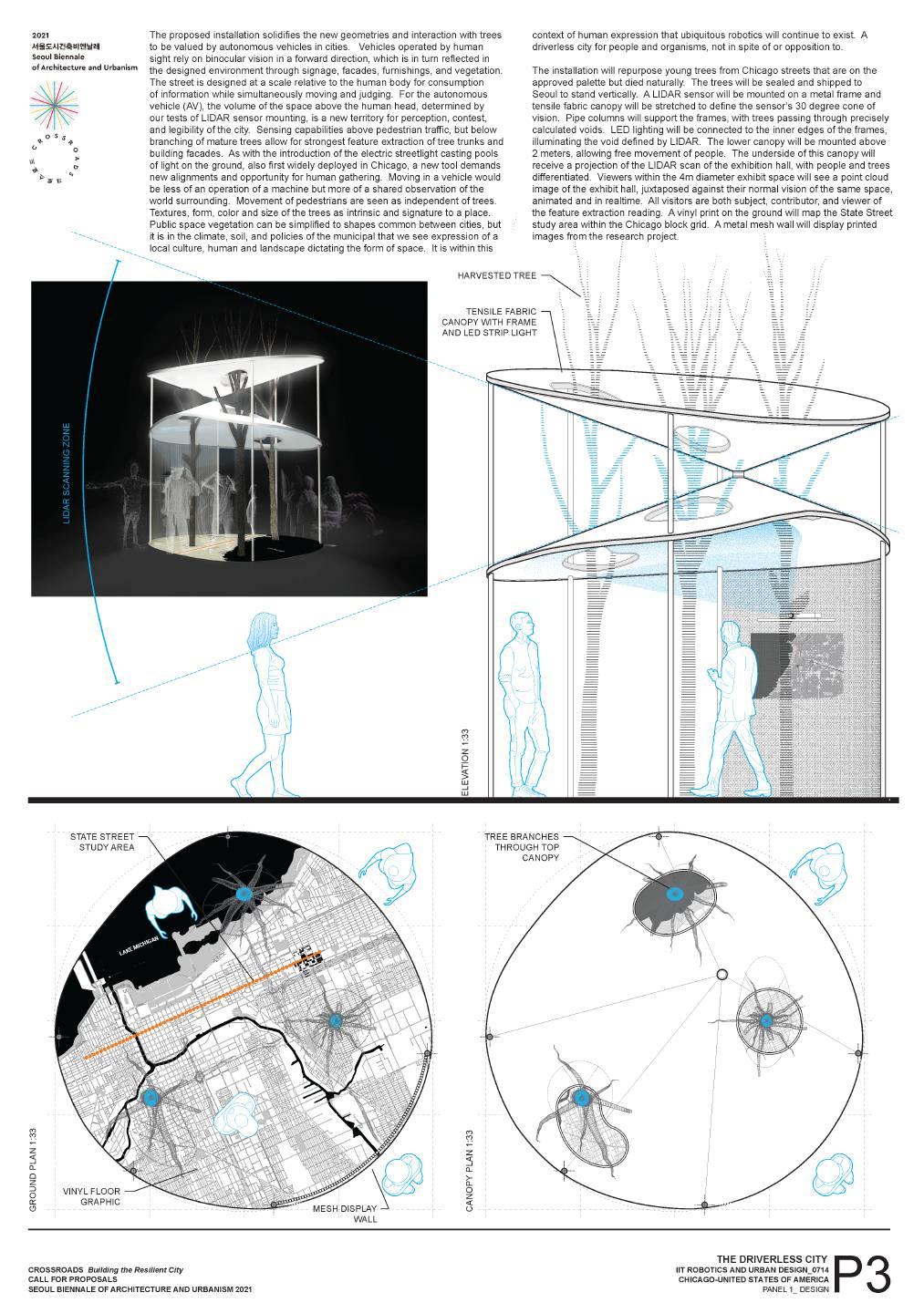
THE DRIVERLESS CITY
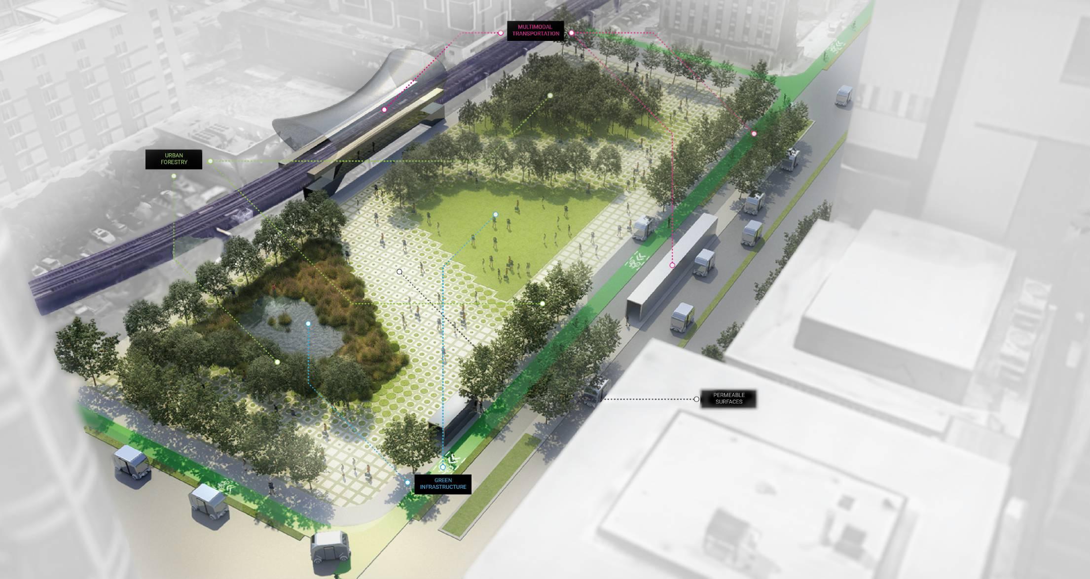
THE URBAN IMPLICATIONS OF AUTONMOUS TECHNOLOGIES RESEARCH ASSISTANT | IIT |
The advent of autonomous and ubiquitous co-robot technologies offers citizens, leaders, and stakeholders the opportunity to recalibrate current automobile transportation infrastructure and, therefore, the morphology of dense urban cores. To do so, we must balance the requirements for navigation safety, functionality, and experiential conditions. This research investigates these trade-offs to understand the impact of driverless vehicles in urban design. The result will be a framework of forecast scenarios that will advise urban designers, policymakers, stakeholders, and the autonomous vehicle industry, on critical factors to consider when deploying these technologies and how to achieve valuable social, environmental, and ex -
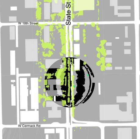
periential outcomes within the existing road infrastructure. This research will address how cities can leverage upcoming mobility technologies to retrofit late-nineteenth-century automobile transportation infrastructure into human infrastructure for the twenty-first century? Furthermore, how can urban public spaces (roads, sidewalks) be built to promote social equity and environmental performance as the number of autonomous vehicles increases? This research examines the possible implications of autonomous vehicles and navigation safety on State Street (Chicago), a significant commercial artery of the city and with a historical morphology intimately related to mobility and infrastructure innovations.
CHICAGO | 2022
There is a clear link between an Autonomous Vehicle’s capability to localize within an environment and that environment’s physical structure. Tall buildings can severely compromise GNSS signals due to blockages in line of sight; for landmark-based navigation, landmarks spaced too far apart decrease localization accuracy, and the same landmarks
spaced too close together can introduce a higher probability of faulty measurement associations. This research builds a technical framework based on current driverless technologies and IIT’s Driverless City project methodology to understand the limitations of GPS availability and Landmark-based navigation. Lastly, the final component will
incorporate speculative scenarios to increase the localization safety of autonomous cars along the chosen transects from both cities. These operations are devised to address socio-environmental issues such as park accessibility, urban heat island effect, and water management.
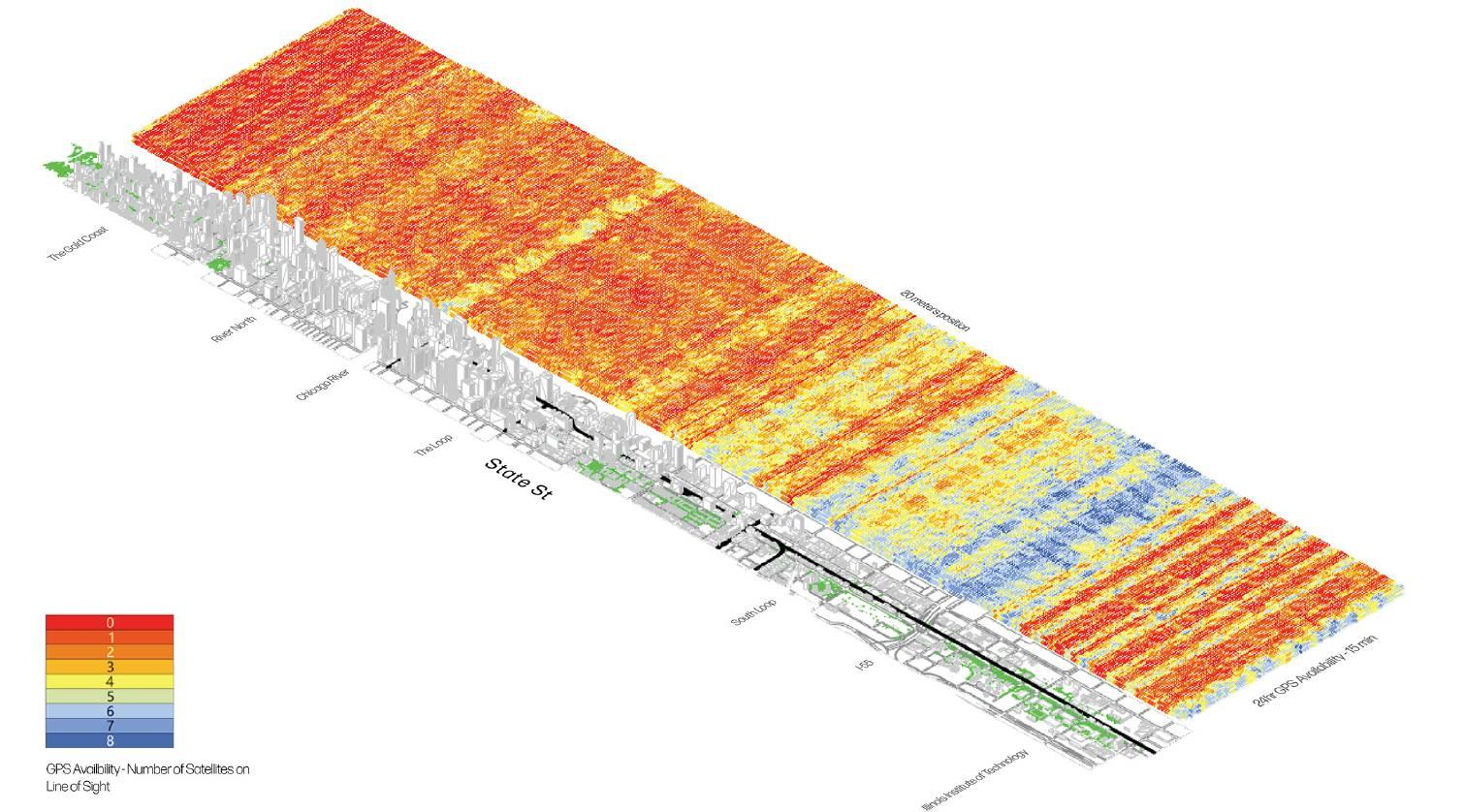
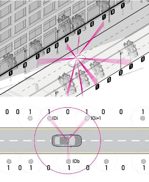
This figure shows an example on how GNSS measurements were formed: a sky map of GNSS constellation is generated at a given time and given location; The grey area are buildings in the area, and any satellites of PRNs that locates within the grey area will be considered unavailable due to building blockage. The red dots on topright indicates GNSS satellites with Line of Sight (LOS), while blue represents non-Line of Sight(NLOS).
NON LINE OF SIGHT LINE OF SIGHT
SHADOW MASKING AND GPS SAT LOCATION
Receiver x,y,z,t LOS:LineofSight SightofLineLOS: SAT 5 SAT 6 SAT SAT 3 SAT SAT NLOS:NonLineofSight SAT GPS AVAILABILITY
STATE
ACROSS
STREET
GPS AVAILABILITY INTERRUPTIONS
BINARY ERROR=CORRECTING CODE PLANTING
In response, the research team combines multiple Ranging and Inertial Sensors with a pseudo-random landscape strategy to provide quantifiable navigation integrity. All objects in urban environments are candidates for external ranging sources for LiDAR. However, we specifically focus on extracting pole-like landmarks (e.g., trees and streetlamps) be-cause of their location flexibility, relative ubiquity, and defined shapes.
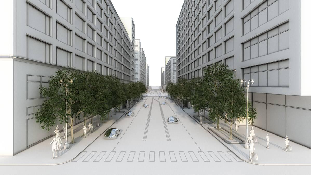
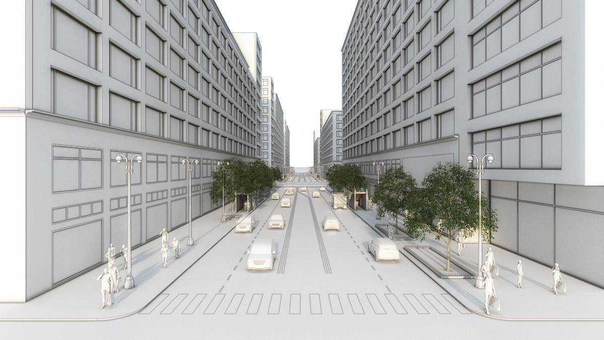
The landscape objects are used in a binary error-correcting code to improve localization safety for autonomous vehicles. Prior research showed that LiDAR measurements using pole-like landmarks improved vehicle localization in
urban environments but that” the accuracy of the localization is highly dependent on the number and density of available landmarks at each scene”. In this work, each landmark mapped in the selected transect is assigned a unique identification (ID) with a given geographical area (Fig.3). This results in bidirectionally decodable landmarks so that robots can read the code while traveling in either direction along a given path. To provide a realistic scenario, we included urbanistic constraints on where these landmarks can be set up. The spacing be-tween new landmarks respects the landscape ordinance of Chicago, spacing trees between 6 and 7.5 meters.
EXISTENT CONDITIONS ERROR CORRECTING CODE-PLANTING ADDITION
We use trees and their location as bits; with a series of trees’ existence and non-existence, we can decode them into identification messages that associate features to pre-mapped landmarks.
The landmarks in the neighboring area must be removed in a radius of 0.40 meters on the X-axis and 5.60 meters on the Y-axis. There a 170 existent landmarks that had to be re-moved in the total transect. In total, the number of landmarks accounting for the existent and the geocoded landmarks, and subtracting the removed, is a total of 3018 landmarks, representing an increase of 17% landmarks along the transect. Adding more Urban Forestry to cities has a positive impact on navigation safe -
ty. Chicago’s current road infrastructure occupies thirty-nine percent of surface coverage, while Parks and public spaces account for only six percent (IBRAHIM ET AL., 2018); therefore, there is plenty of room to improve the urban forestry on public roads, exponentially increasing their benefits. An increase from 8\% to 22\% in canopy coverage can help mitigate the urban heat island effect, improve urban rainwater management, generate green and social corridors. amongst other benefits.
What if…?
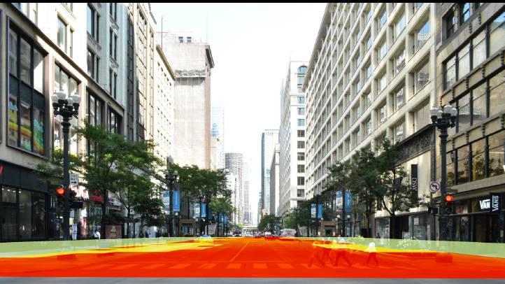
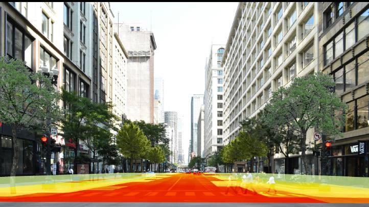
UTCI simulations indicate that State Street could decrease temperatures up to six degrees Celsius. 8% CANOPY COVERAGE - UTCI SIMULATION 22% CANOPY COVERAGE - UTCI SIMULATION
800 ft2 800 ft2
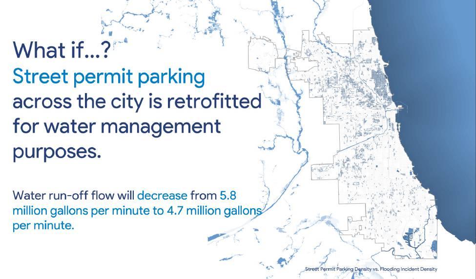
The current infrastructure 800 ft2 of the impermeable surface represents a flow of 26 gallons per minute of run-off water. Dragging pollutants and overflowing the sewage system.
Retrofitted Street Parking Retrofitting 160 ft2 (parking size) reduces the runoff to 21 gallons per minute.
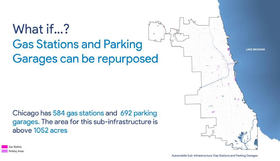
CAN WE REPURPOSE THIS PRIME LAND? FOR ECOLOGICAL BENEFIT OF CITIES?
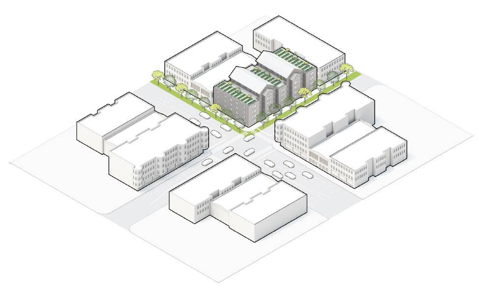
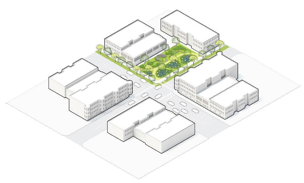
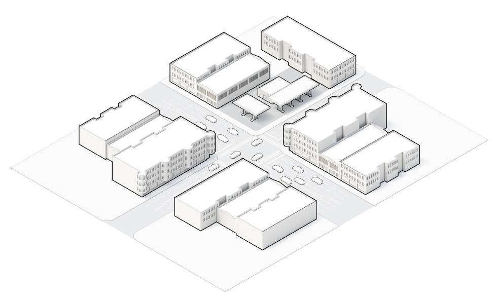
OR FOR SOCIAL PURPOSES?
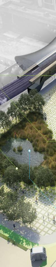
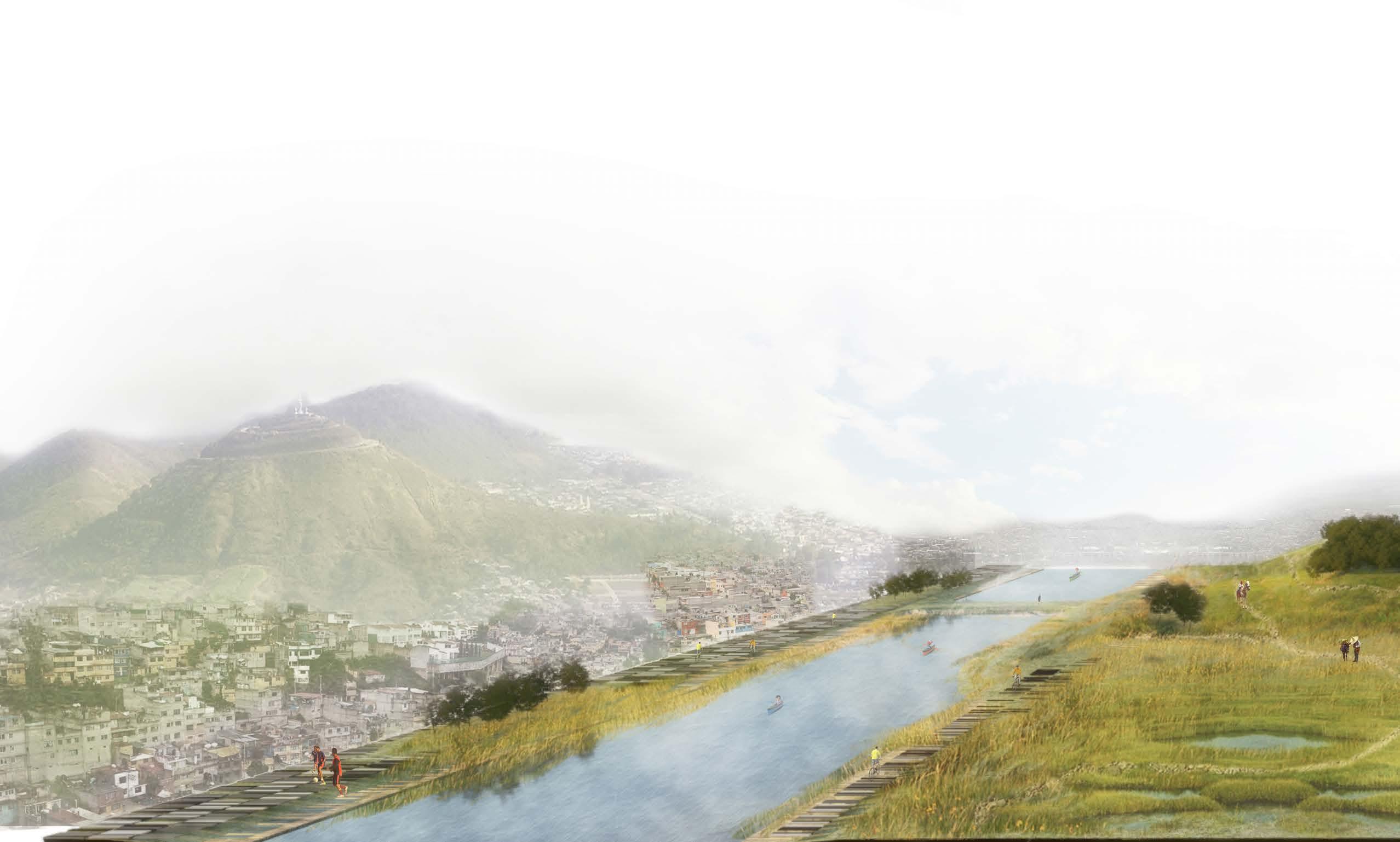
TRANSITIONAL ECOLOGIES
REGENERATION OF THE LACUSTRINE IDENTITY OF TEXCOCO
CLOUD
STUDIO I - GRADUATE SCHOOL | IIT | MEXICO CITY | 2019
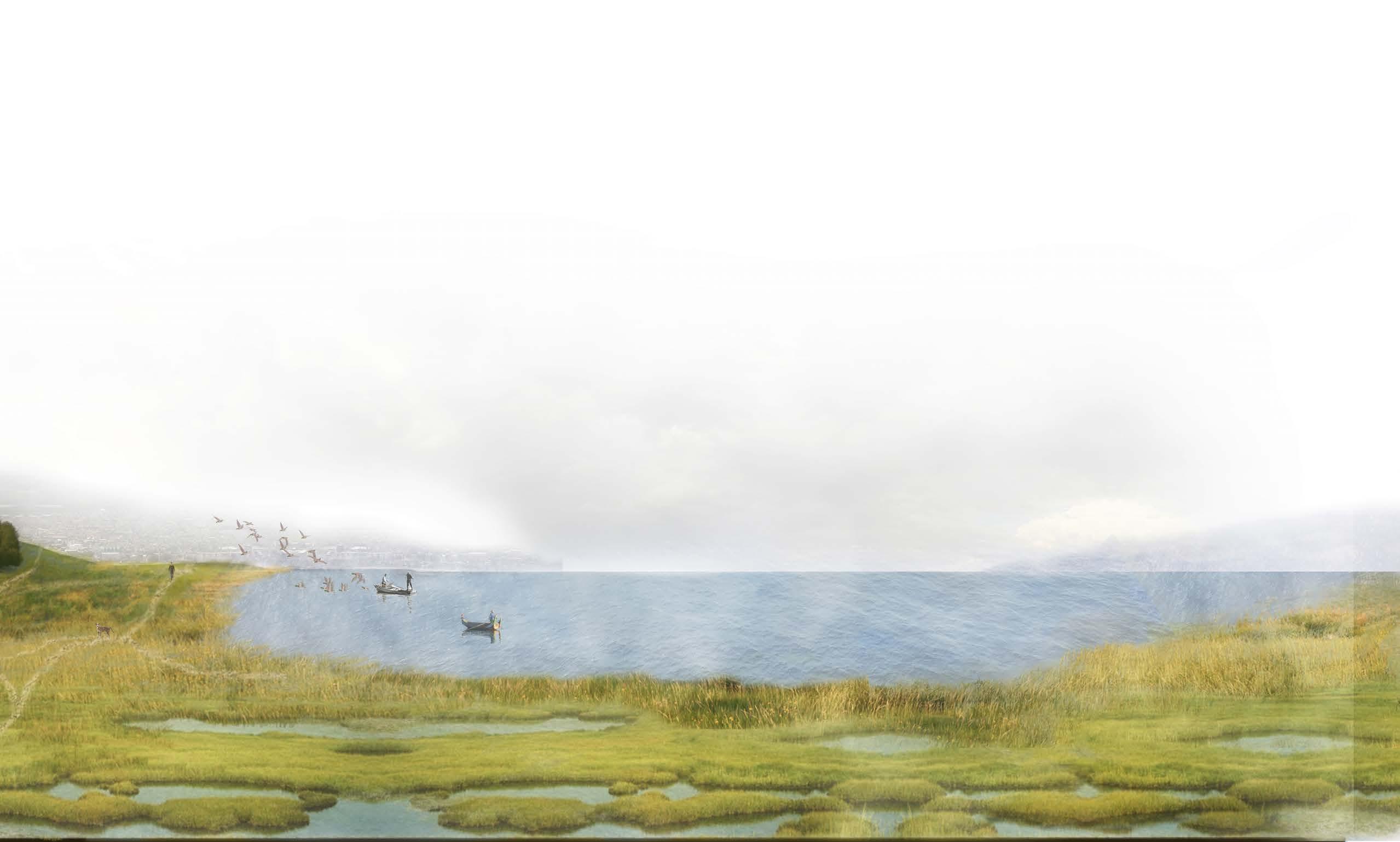
Transitional Ecologies establishes a successional botanical landscape for the site of the canceled project of Mexico City’s new airport. The place was the last remnant of Lake Texcoco, one of Mexico City’s historic lakes and a rare global high-altitude saline-lacustrine habitat. The proposed airport, designed by the architect, Norman Foster, was partially constructed, this operation required the drainage of the last water bodies existent on site. It required the
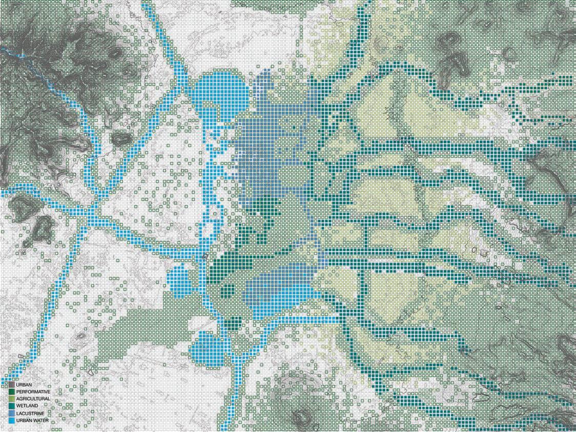
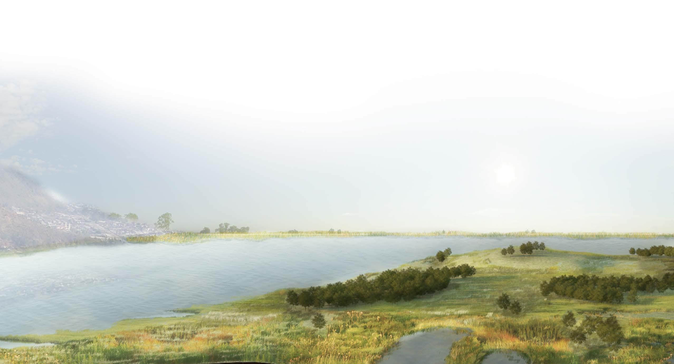
import of 30 million cubic feet of volcanic rock. It was an ecological disaster that was halted by the national referendum following the election of the new government of Mexico in 2018. The studio proposition was to design a botanic garden. As a consequence of the scale of the site, it will be the most extensive botanical garden in the world. Due to its environmental degradation, the design requires a re-thinking of the 21st century botanic garden.
SUBLIME PAST | LAKE TEXCOCO
During the 17th century, the Texcoco Lake was the most important water body in the Mexico Valley watershed.
REMNANTS PRESENT | LAKE TEXCOCO
However, human operations drained the lake until its bed was exposed and consequently degraded to a point of desertification.
RESILIENCE FUTURE | LAKE TEXCOCO
The project aims to rescue and use the remaining ecological features, with the intention of expanding them and to recover the landscape, understanding that it will never go back to its original identity.
TEXCOCO TRANSECTS COMPOSITION
LAKE TEXCOCO SYSTEMATIC OPERATIONS
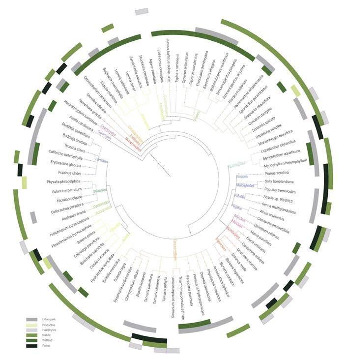
NATIVE SPECIES
PHASES OF CONSOLIDATION
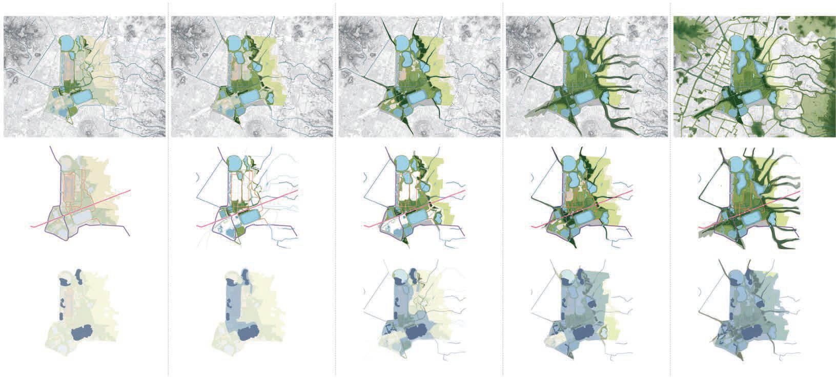
PHASE 1
PHASE 2 REMEDIATION PHASE 3 NATIVE PLANTING PHASE 4 CONSOLIDATION PHASE 5 EXPANSION
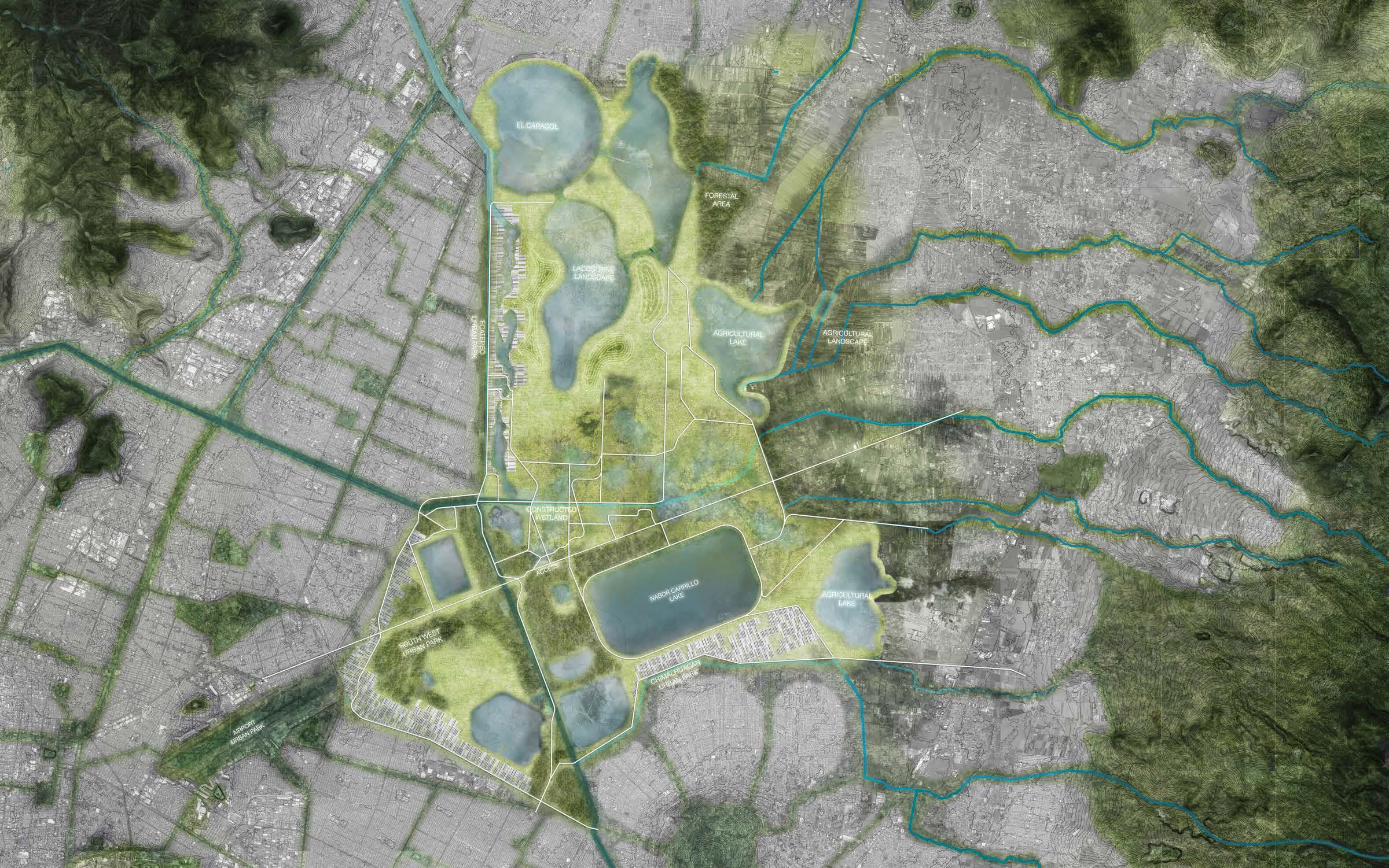
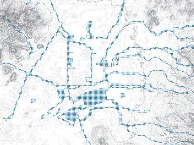
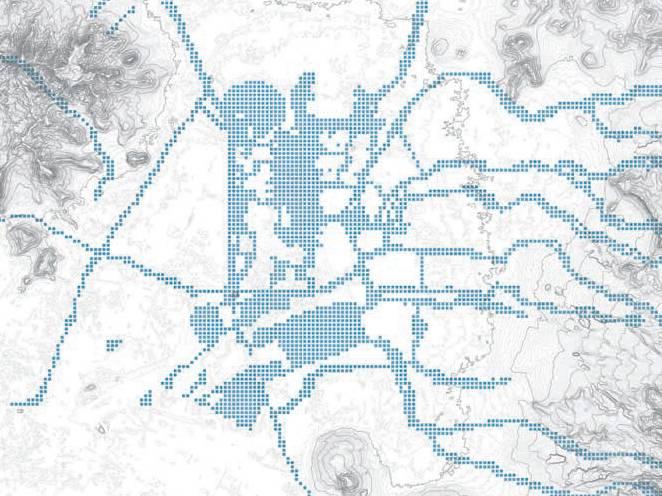
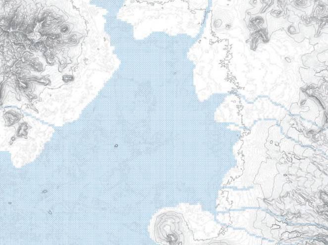
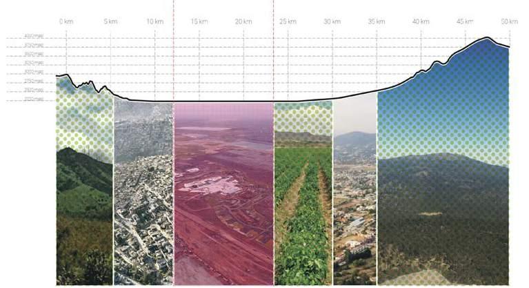
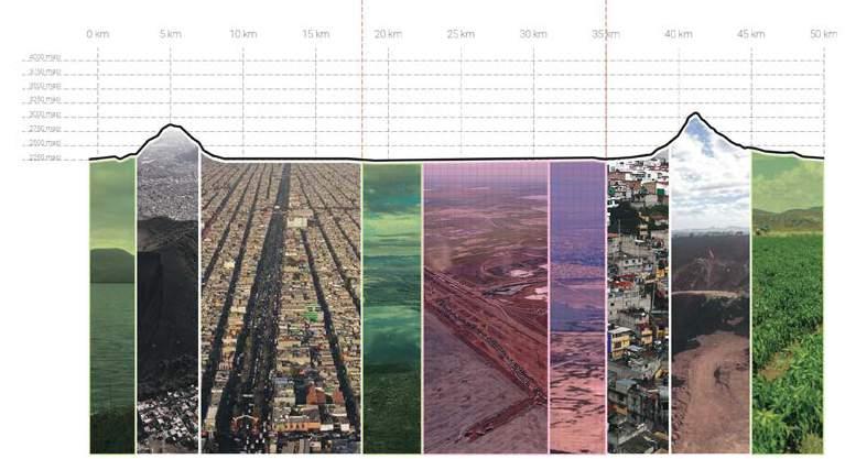
MASTER PLAN PARK LAKE TEXCOCO 0 0 10km 9 8 7 6 4 3 2 1 5km
Mexico City is the third-largest city in Latin America. The city developed over time in a valley formed by a system of 5 lakes (Chalco, Xochimilco, Texcoco, Zumpango, Xaltocan) surrounded by the Guadalupe mountain range to the north, the Chapultepec mountain to the north-west, and the volcanic mountain range of Santa Catarina to the southeast. The studio explores this geological diversity and its role in the evolution of the botanical gardens in the city as a hybrid architectural and landscape ty pology. The work will focus on the cul tural, biological, and pedagogical leg acy of Mexico City’s botanical gardens and their long-lasting urban nature. Working together, students from differ ent backgrounds will have the opportu
nity to form personal and collective understandings of what cross-disciplinary explorations mean in their research, design proposals, and create hypothetical implementation strategies.
With such a large site to develop into a functioning and healthy space, the approach to the site is based in systematic operation of the habitats composing it. It enhances the existent areas to create most impact with the least amount of effort. These prioritized areas simultaneously would provide staging of plants and other resources for future areas, while also creating recognizable and accessible parts.
The project is focused on the understanding of how the diverse, multi-layered, complex conditions of the tropics works as a network that goes beyond political, geographical,
and chronological boundaries. This nutures a responsibility toward native landscapes and ecologies, that reflect a worldly awareness of vegetation, migrational patterns, and growth as a tool for self-sustaining resilience. Adding to this, the social component of ephemerality that forms long-lasting cultural conditions and the consequential identities of place and user.
4151 2239 2001 3055
DRAWINGS AND DETAILS
ALEXIS ARIAS BETANCOURT
CONSTRUCTION
W57 Street W57 Street W57 Street W59 Street W59 Street W59 Street W58 Street L.P593ft L.P 593 ft L.P 593ft 5% 5% 5% 5% 5% 5% 5% 5% 5% 5% 5% 596 ft 595ft 600ft 600ft 605ft 608 ft 610ft 613H.P ft S Lowe Ave S Lowe Ave 10' 25' 50' 100' 250' 500'
www.aiearquitectura.com ai+e arquitectura integral + experimental CASA RB
1 ARQ. ALEXIS ARIAS ARQ. PABLO MONCAYO ai+e "C" Profile 20 mm Weld Bead IPE 27 Profile Metallic Rod Metallic Tube 200x100 Polycarbonate Sheet 10mm Metallic Tube 50x50 IPE 20 Profile Glass 6mm Aluminum Window Profile 4mm Sliding Window Door Steel Column Metallic tube 200 x 200 Porcelain Tile 10 mm thickness Steel Rebar 20mm diameter bar @ 20cm interval Reinforcement Mesh 8mm diameter bar @ 20cm interval Concrete Slab 70 mm above Steel Deck Welded Shear Studs Tightening Bolt Nut Steel Plate Leveling bolt nuts Reinforcement rebar 10 mm diameter @ 100 mm Grass Level Concrete Footing FOOTING AND STRUCTURAL PLAN 1:150 STRUCTURAL SCHEME SECTION WALL 1:25 A B C D 6 5 4 3 2 6500 5900 5900 18300 500 500 1000 450 550 1000 225 225 450 500 500 1000 325 550 225 450 500 500 1000 325 450 2776 450 750 750 175 2626 225 375 750 325 450 225 450 375 375 750 175 750 325 450 225 450 500 500 1000 3000 3800 1900 3200 2500 14400 225 450 500 500 1000 225 450 500 500 1000 200 225 450 500 500 1000 325 550 450 550 1000 225 450 500 500 1000 325 550 1000 325 675 225 450 625 625 1250 225 450 625 625 1250 325 225 450 500 850 325 550 225 450 500 500 450 225 625 625 1250 225 450 625 625 1250 225 450 225 625 625 1250 225 450 625 625 1250 625 625 1250 450 625 625 1250 225 450 450 225 500 500 1000 225 450 500 500 1000 225 450 500 500 1000 225 500 500 1000 450 225 450 500 500 1000 225 450 500 500 1000 500 500 225 450 1000 225 450 500 500 1000 600 500 500 300 500 500 300 200 500 550 500 1350 1850 1500 500 1350 1850 500 500 1149 850 500 500 200 500 500 1000 2149 1649 500 500 200 900 500 500 200 1400 500 1900 1400 500 1400 500 500 500 200 500 500 900 200 P2 e=30cm N.C.-2.00m P1 e=30cm N.C.-2.00m P1 e=30cm N.C.-2.00m P1 e=30cm N.C.-2.00m P1 e=30cm N.C.-2.00m P1 e=30cm N.C.-2.00m P2 e=30cm N.C.-2.00m P4 e=30cm N.C.-2.00m P2 e=30cm N.C.-2.00m P2 e=30cm N.C.-2.00m P2 e=30cm N.C.-2.00m P2 e=30cm N.C.-2.00m P2 e=30cm N.C.-2.00m P2 e=30cm N.C.-2.00m P2 e=30cm N.C.-2.00m P2 e=30cm N.C.-2.00m P3 e=30cm N.C.-2.00m P3 e=30cm N.C.-2.00m P3 e=30cm N.C.-2.00m P5 e=30cm N.C.-2.00m 1
DETALLES CONSTRUCTIVOS
VIGA PRINCIPAL IPE 25
CIELO RASO - PANELADOS YESO -INSTALACIONES ELECTRICAS
MAMPOSTERIA BLOQUE HORMIGON
GYPSUM WALL
VIGUETAS METALICAS TUBULARES
STEEL DECK CONTRAPISO HORMIGON
BORDILLO HORMIGON-MAMPOSTERIA
TUBO DE ACERO GALVANIZADO
MALLA DE ACERO GALVANIZADO PERFIL DE REMATE DE ACERO
LAMINA DE ACERO 3mm ATORNILLADA
PERFIL ALUMINIO ESTRCUTURAL - VIDRIO TENSADO
PERFIL DE REMATE DE ACERO
LAMINA DE ACERO 3mm ATORNILLADA
SUSTRATO
PERFIL DE REMATE DE ACERO
GRAVA
SUSTRATO
CAMA DE HORMIGON DRENAJE VIGA DE BORDE IPE 80
LAMINA DE ACERO 3mm ATORNILLADA
PERFIL DE REMATE DE ACERO
DETALLE DE CUBIERTA AJARDINADA
VIGA METALICA ACABADO EXTERIOR
PERFIL C 250mm x 100mm
VIDRIO TENSADO 6mm
DINTEL MAMPOSTERIA
PERFILERIA ALUMINIO - VIDRIO TENSADO
PASAMANOS EXTERIOR METALICO
PERFILERIA ALUMINIO - VIDRIO TENSADO
CONTRAPISO HORMIGON
MUROS GAVIONES DE SOPORTE ESTRUCTURAL
ZAPATAS Y CIMIENTOS HORMIGON ARMADO
44 17 226 380 282 270 60 275 230 320 128
CORTE POR FACHADA 1:100
STUDENT HOUSING UNDERGRAD FINAL PROJECT QUITO | 2014
inspect them after delivery to the site. All plant materials shall be inspected by the Landscape Architect on site prior to installation.
9. All proposed plants shall be located carefully as shown on the plans and the placement shall be approved by Landscape Architect before the plants are installed. Landscape Architect reserves right to adjust location of plants.
10. All disturbed areas not to be paved or planted shall be loamed and seeded as shown. The seed mix specifications will be from Wetland Plants, or similar as approved by Landscape Architect.
11. Staking and tree-staying shall be determined by the Landscape Architect on tree by tree basis. For pricing purposes, provide per tree unit cost for staking and guying. staking and tree-staying is required, remove tree wrap, stakes, and tree-stay poles and rope at end of first growing season.
12. Prune any broken, crossing or rubbing branches.
13. For tree planting in lawn areas, any disturbed lawn shall be loamed and seeded as necessary
14. Planting will occur in phases coordinated with the phased construction of the residential units.

15. Seeding of meadows and lawns shall occur between July 15 and September 15. Top seeding of meadows and lawns may be performed in the spring or fall.
16. Plants shall be warranted for two growing seasons encompassing full growing seasons between May 01 through September 30.
MAN-MADE TRANSECTS


S. LAKE SHORE DR. E 87TH STREET E 85TH STREET 87TH STREET S. L AKE SHORE DR. NORTH
050100 200 500 1000 2500
dioicus (135) 30’ x 30’ grid OH Hydrangea Quercifolia(260) KSV Viburnum carlesii(150) SC Malus sargentii(150)
SLIP
K.C. Gymnocladus
nigra (180) 25’ x 25’ grid B,G, Nyssa sylvatica (200) 20’ x 20’ grid
Cercis canadensis (280) 20’ x 20’ grid B.F Forsythia x intermedia (340)
R.B Betula
R.B.
grandiflora(205) 15’ x 15’ grid 501,898.00 sqft midwest prairie planting AP Aesculus parviflora(100)
S.B. Amelanchier x
1000’ 500’ 200’ 100’50’0’ 0 12 12 24 24 60 60 1 1 L 1.1 L 2.1 L 2.1 N PLANTING PLAN NOTES 1. Planting contractor shall visit site prior to submitting bid to become completely familiar with site conditions. 2. No planting will be installed until all grading and construction has been completed in immediate area. 3. Contractor to verify all utilities on property and to protect all utilities during excavation for plants. 4. If there is a discrepancy between the number of plants shown on the plan and the number of plants shown in plant list, the number of plants shown on plan will take precedence. 5. All container material to be grown in container a minimum of months. 6. All material shall comply with the latest edition of the American Standard for Nursery Stock, American Association of Nurserymen. 7. Contractor shall repair all damage to property from planting operations at no cost to the owner 8. The Landscape Architect will tag all plants at the nursery and
existing
18.
crown lifting as outlined in specifications. LANDSCAPE ORDINANCE 1. Required Tree Canopy Percentage Sufficient trees shall be retained and/or planted on lot so that the square footage of vegetative canopy of such trees, when mature, equals certain percentage of the square footage of the lot. This required percentage is established by district as follows: a. All residential districts, and the PS, OS, and CD Districts: 30% of the square footage of the lot b. I-1 and I-2 Districts: 30% of the square footage of the lot c. D-1 District: 15% of the lot area not occupied by structure d. All other districts: 15% of the square footage of the lot 2. Calculation of Tree Canopy Coverage The total canopy coverage for lot is the sum of the canopy, at maturity, of the individual trees located on the lot. The square footage of canopy cover varies according to tree species. The City Forester maintains list of trees species and the expected size of the canopy for each species, at maturity when planted. rees are classified as small, medium, or large and the canopy coverage credit for each classification is as follows: a. Large: 1,000sf b. Medium: 700sf c. Small: 300sf CODE KC RB BG RB SB BF OH KSV SC AP CODE KC RB BG RB SB CODE KC RB BG RB SB BF HQ KSV SC AP CWM QTY 135 180 200 280 205 340 260 150 150 100 QTY 135 180 200 280 205 QTY 135 180 200 280 205 340 260 150 150 100 287 UNIT COST($) 1,285.00 558.00 429.00 380.00 505.00 30.50 41.00 64.50 153.00 153.00 39.50 SUBTOTAL 3X CONSTRUCTION SUBTOTA AREA AREA OF SITE % COVER COST($) 173,475.00 100,440.00 85,800.00 106,400.00 103,525.00 10,370.00 10,660.00 9,675.00 22,950.00 15,300.00 11,336.50 649,931.50 1,949,794.50 505,100.00 2,962,319.00 17% SCIENTIFIC NAME Gymnocladusdioicus Betulanigra Nyssasylvatica Cercis canadensis Amelanchier x grandiflora Forsythiaxintermedia Hydrangeaquercifolia Viburnum carlesii Malussargentii Aesculusparviflora SCIENTIFIC NAME Gymnocladusdioicus Betulanigra Nyssasylvatica Cerciscanadensis Amelanchier x grandiflora SCIENTIFIC NAME Gymnocladusdioicus Betulanigra Nyssasylvatica Cercis canadensis Amelanchier x grandiflora Forsythiaxintermedia Hydrangeaquercifolia Viburnum carlesii Malussargentii Aesculusparviflora Conservation Wildlife mix COMMON NAME Kentucky coffee tree river birch “cully“ blackgum eastern red bud apple serviceberry border forsynthia oakleaf hydrangea Korean spice viburnum Sargent’s crabapple bottlebrush buckeye COMMON NAME Kentucky coffee tree river birch “cully“ blackgum eastern red bud apple serviceberry CANOPY (sqft) 950.00 715.00 410.00 425.00 230.00 TOTAL(sqft) 128,250.00 128,700.00 82,000.00 119,000.00 47,150.00 MEADOW Meadow shall be comprised of: New England Conservation/Wildlife mix from New England Wetland Plants, Inc.(CWM) TREE CANOPY COVER CALCULATIONS PLANTING COST ESTIMATE PLANTING LIST: TREES AND SHRUBS STEELWORKERS PARK SITE PLAN CERCIS CANADENSIS PLANTING DETAIL MEADOW SHRUBS ELEVATED WALKWAY DETAIL COMPACTED SOIL 18” STAKE GUYING WIRES STRAND TWIST GUYING WIRES STRAND TWIST SPECIFIED PLANTING MIX ROOT BALL 2” CERCIS CANADENSIS RUBBER HOSE 1” DIAMETER 12” 3’6” 2”X6” RAIL 2”X6” JOIST 2”X8” BEAM CONCRETE FOOTING COMPACTED AGGREGATE SOIL 2”X6” PLANKING 2”X6” RAIL 4”X4” POSTS ROOTBALL MIN 2X DIAMETER ROOT BALL THOUSAND TREES PROJECT STEELWORKERS PARK L1.1 STEELWORKERS PARK S LAKE SHORE DR & E 87TH ST. LA 567 ECOLOGY AND MATERIALS WORKSHOP III ALEXIS XAVIER ARIAS BETANCOURT P an ng scheme or a succes ona ga den n S ee Wor e s Park FINAL REVIEW TOTAL AREA: Application rate: Pounds required: 501,898.00 sq ft. lb/2,500.00 sq ft. 287 lbs. SIZE 7” cal. 14/16’ clump 2.5” cal 2” cal 12’ height #3 #3 #5 #15 #7 501,898.00 SIZE 7” cal. 14/16’ clump 2.5” cal 2” cal 12’ height #3 #3 #5 #15 #7 24" 12"6" 60" 016"12" Gymnocladus dioicus Kentucky coffe tree Betula nigra river birch Òcully Nyssa sylvatica blackgum Cercis canadensis red bud Amelanchier grandiflora apple serviceberry NORTH SLIP Gymnocladus dioicus (135) KSV Malus sargentii(150) R.B Betula nigra (180) Nyssa sylvatica (200) R.B. (280) Amelanchier grandiflora(205) 15’ grid 501,898.00 midwest prairie planting AP MAN-MADE TRANSECTS 100 Years 50 Years 25 Years 10 Years 1000 TREES PROJECT SUCCESIONAL GARDEN IN STEEL WORKERS PARK ECOLOGY WORKSHOP | IIT | CHICAGO | 2019
17. Provide crown cleaning for all
trees to remain (except woodland trees).
Provide
ENGLEWOOD RAIL PARK
PLANTING / HABITAT PLAN
SLOPE TREES NORTH WEST / Quercus alba 12) irregular pattern
NORTH BIRCH GROVE / Betula papyrifera (18) 30’ x 30’ grid
NORTH POPLAR GROVE/ Populus deltoides (78 30’ x 30’ grid
WEST POPLAR GROVE/ Populus deltoides (43 30’ x 30’ grid
SOUTH EAST POPLAR GROVE/ Populus deltoides (110 30’ x 30’ grid
EAST BIRCH GROVE / Betula papyrifera (44)
30’ x 30’ grid
SOUTH WEST BIRCH GROVE / Betula papyrifera ( 35)
30’ x 30’ grid
SLOPE TREES EAST / Quercus alba ( 39) irregular pattern
SLOPE TREES WEST/ Quercus alba 15) irregular pattern
PRAIRIE MIX
8.34 acres
SLOPED PRAIRIE MIX
6.74 acres
MESIC PRAIRIE MIX
5.30 acres
W57 Street W57 Street W57 Street W59 Street W59 Street W59 Street W58 Street L.P593ft L.P 593 ft L.P 593ft 5% 5% 5% 5% 5% 5% 5% 5% 5% 5% 5% 596 ft 595ft 600ft 600ft 605ft 608 ft 610ft 613H.P ft W58 Street S Shields Ave S Shields Ave S Lowe Ave S Lowe Ave 0 10' 25' 50' 100' 250' 500' 1000'
2020 1”=100’-00”
SPRING
ENGLEWOOD RAIL PARK PHYTOREMEDIATION GARDEN FOR THE COMMUNITY CLOUD STUDIO II | IIT | CHICAGO | 2020
HOUSE ON A HILL CIRCULATION GRADING ECOLOGY WORKSHOP | IIT | CHICAGO | 2019 BOUNDARY NOTE: BOUNDARY LINES FROM PLAT BY CRAPNELL LAND SURVEYING DATED 06/02/04 RECORDED AS DOC. #2004-21317 BEARINGS ADJUSTED TO IOWA STATE PLANE NAD 83 (2011) ADJUSTMENT 1' 10' 5' 20' 0 SCALE: 1" = 10'-0" N ALEXIS ARIAS LA-566 ECOLOGY & MATERIALS WORKSHOP FINAL EXAM 649 653 652 651 650 647 646 645 643 648 PEDESTRIAN ENTRANCE 602 603 604 607 608 609 613 615 617 618 619 620 621 623 624 625 627 628 631 632 633 634 635 636 637 639 640 641 642 644 647 648 651 652 654 8% 7% 8% 8% 8% 8% 653 BS 652.55 652.5 BS 652.05 652 BS 651.55 651.5 BS 651 653 BW 652.1 652 BW 651.1 TW 651 BW 651 652 653 650 649 648 647 646 645 644 643 642 649 648 8% 8% 8% 8% 8% 8% 8% 8% 8% 8% 8% 8% 8% 8% 8% 8% 8% 8% 8% 8% 8% 8% 8% 8% 8% 8% 8% 8% 8% 8% 8% 8% 8% MAIN ENTRANC DRAINAGE DRAINAGE DRAINAGE
DRIVERLESS CITY PAVILION SEOUL BIENNALE OF ARCHITECTURE AND URBANISM PAVILION PROPOSAL | 2020
N c+33,5 c+34,5 Inngang c+35 Inngang c+37,5 c+37 c+36,5 c+36,5 c+36 c+33,5 c+36 c+35,5 c+35,5 c+33,5 Inngang c+33,5 c+34,5 Inngang c+35 c+35 c+34,5 c+35 c+35,7 Inngang c+35,5 c+33,5 Inngang Inngang c+33,5 c+36 c+33,5 c+33,5 Inngang c+34,5 c+31,8 Inngang Inngang c+35,6 Inngang c+33,5 c+34,6 Inngang c+34,5 c+34,6 c+34,4 c+34,3 c+35 c+34,5 c+33,5 c+34,5 c+33,5 Inngang c+35 c+34 c+34 Inngang c+35,8 c+35 c+33 Inngangc+34 c+35,5 c+36 Inngang c+36,5 Inngang c+33 c+33 c+34 c+33,5 Inngang c+33,5 c+34,7 c+33,5 34,7 34,5 34,9 35.1 35.3 35.3 35,5 33,7 33,9 34,1 34,3 c+34,5 34,7 34,9 35,1 35,3 35,5 8% 7 3 3 9 3 3 34,1 34,3 34,5 34,7 34,9 35,1 35,3 PARKVEIEN HOUSING COMPLEX IN OSLO NORWAY | 2019
24.30 17.63 15.30 24.45 1.50 4.50 6.00 1.50 7.95 9.45 EJE DE LA CALLE BARRIGA EJE DE LA AVENIDA KENNEDY 16% A05 A05 B 1 2 3 4 5 A C 13.00 5.60 6.00 1 2 3 4 5 B A C 24.40 5.90 2.60 6.00 5.90 OCTUBRE/2016 TIPO DE PLANOS Nº DE PREDIO ESCALA 1 2 UBICACIÓN 3 CONTENIDO NOMBRE DEL ARCHIVO PBG PLANOS ARQUITECTONICOS.dwg EL DIMENSIONAMIENTO PREVALECE SOBRE LA ESCALA SERÁ COMPROBADO EN OBRA LOS DERECHOS DE LA INFORMACIÓN EN ESTOS DOCUMENTOS PERTENECEN ALEXIS ARIAS ARQUITECTO ESTÁ PROHIBIDA SU REPRODUCCIÓN, MODIFICACIÓN Y/O COMERCIALIZACIÓN PARCIAL O TOTAL PROPIETARIOS 4 LÁMINA FECHA REG. MUN. CED RUC DISEÑO CED RUC CLAVE CATASTRAL ARQUITECTONICOS USO MIXTO EDIFICIO PBG MACHACHI CED RUC AA-01 IMPLANTACION 1:100 ARQ. ALEXIS ARIAS PABLO BETANCOURT GAVILANEZ ZOILA GAVILANEZ 5003018017 171491312-4 171675473-2 LUISFELIPEBARRIGA QUISHUAR GENERAL RUMIÑAHUI LUISFELIPEBARRIGA LUISFELIPEBARRIGA AV.KENNEDY AV.KENNEDY ESTADIO "MACHACHI" UBICACIÓN 704 2016
24.30 17.63 15.30 24.45 1.50 4.50 6.00 1.50 7.95 9.45 EJE DE LA CALLE BARRIGA EJE DE LA AVENIDA KENNEDY 16% N-2.58 N-2.40 1 2 3 4 5 B A C 1 2 3 4 5 B A C 5.90 5.70 2.60 5.70 24.10 13.00 5.60 6.00 16.40 14.30 3.75 5.00 3.40 4.80 2.30 2.32 3.00 3.00 2.75 2.75 2.35 2.35 2.25 3.30 3.60 2.25 2.50 4.20 AA12 AA11 Cisterna Cuarto de Maquinas AA11 AA12 OCTUBRE/2016 TIPO DE PLANOS Nº DE PREDIO ESCALA 1 2 UBICACIÓN 3 CONTENIDO NOMBRE DEL ARCHIVO PBG PLANOS ARQUITECTONICOS.dwg EL DIMENSIONAMIENTO PREVALECE SOBRE LA ESCALA SERÁ COMPROBADO EN OBRA LOS DERECHOS DE LA INFORMACIÓN EN ESTOS DOCUMENTOS PERTENECEN ALEXIS ARIAS ARQUITECTO ESTÁ PROHIBIDA SU REPRODUCCIÓN, MODIFICACIÓN Y/O COMERCIALIZACIÓN PARCIAL O TOTAL PROPIETARIOS 4 LÁMINA FECHA REG. MUN. CED RUC DISEÑO CED RUC CLAVE CATASTRAL ARQUITECTONICOS USO MIXTO EDIFICIO PBG MACHACHI CED RUC AA-02 SUBSUELOS ARQ. ALEXIS ARIAS PABLO BETANCOURT GAVILANEZ ZOILA GAVILANEZ 5003018017 171491312-4 171675473-2 1:100 LUISFELIPEBARRIGA QUISHUAR GENERAL RUMIÑAHUI LUISFELIPEBARRIGA LUISFELIPEBARRIGA AV.KENNEDY AV.KENNEDY ESTADIO "MACHACHI" UBICACIÓN 704 2016
24.30 17.63 15.30 24.45 1.50 4.50 6.00 1.50 7.95 9.45 EJE DE LA CALLE BARRIGA EJE DE LA AVENIDA KENNEDY 1.60 1.60 1.60 2.10 1.60 1.60 1.60 2.10 16% N±0.00 1 2 3 4 5 B A C 1 2 3 4 5 B A C 5.90 5.70 2.60 5.70 24.10 13.00 5.60 6.00 16.40 1.25 2.00 1.75 0.80 1.25 2.00 1.75 0.80 0.20 2.40 0.20 0.80 1.45 2.00 1.10 2.00 1.45 0.80 0.29 0.20 0.90 0.40 5.60 0.40 5.10 0.40 0.20 3.84 1.10 4.65 0.30 2.30 0.30 5.40 0.50 5.40 0.30 4.85 4.85 12.60 1.60 1.60 1.60 2.10 1.60 1.60 1.60 2.10 12.60 7.30 5.90 7.30 5.70 Comercio Comercio Comercio 3 Comercio 4 Cubierta Parqueadero B AA12 C AA13 D AA14 AA11 A AA11 B AA12 C AA13 D AA14 18 19 OCTUBRE/2016 TIPO DE PLANOS Nº DE PREDIO ESCALA 1 2 UBICACIÓN 3 CONTENIDO NOMBRE DEL ARCHIVO PBG PLANOS ARQUITECTONICOS.dwg EL DIMENSIONAMIENTO PREVALECE SOBRE LA ESCALA SERÁ COMPROBADO EN OBRA LOS DERECHOS DE LA INFORMACIÓN EN ESTOS DOCUMENTOS PERTENECEN ALEXIS ARIAS ARQUITECTO ESTÁ PROHIBIDA SU REPRODUCCIÓN, MODIFICACIÓN Y/O COMERCIALIZACIÓN PARCIAL O TOTAL PROPIETARIOS 4 LÁMINA FECHA REG. MUN. CED RUC DISEÑO CED RUC CLAVE CATASTRAL ARQUITECTONICOS USO MIXTO EDIFICIO PBG MACHACHI CED RUC AA-03 PLANTA BAJA ARQ. ALEXIS ARIAS PABLO BETANCOURT GAVILANEZ ZOILA GAVILANEZ 5003018017 171491312-4 171675473-2 1:100 LUISFELIPEBARRIGA QUISHUAR GENERAL RUMIÑAHUI LUISFELIPEBARRIGA LUISFELIPEBARRIGA AV.KENNEDY AV.KENNEDY ESTADIO "MACHACHI" UBICACIÓN 704 2016
1 2 3 4 5 B A C 1 2 3 4 5 B A C 4.45 S L Sala/Comedor Cocina Lavanderia Dormitorio 1 Dormitorio Master Baño 3,30m2 N+3.40 Ingreso a Departamentos 11 10 L S Sala Comedor Cocina/lavanderia Corredor/Mueble Dormitorio 2 Dormitorio Dormitorio Master Baño 3.20 2.65 3.20 2.65 3.30 3.30 0.90 2.30 1.50 1.50 2.30 1.35 2.50 2.90 3.35 3.00 5.60 3.20 3.20 5.40 2.60 3.90 2.70 0.90 3.20 3.40 4.80 3.00 1.50 2.60 2.20 1.50 2.10 3.50 1.50 5.90 5.70 2.60 5.70 24.10 0.60 1.80 2.00 0.10 2.00 0.85 2.40 0.10 5.90 0.80 3.30 13.00 5.60 6.00 1.10 1.50 3.00 0.60 1.00 1.50 0.60 1.70 0.60 1.40 1.10 0.40 1.90 4.10 1.10 0.20 1.10 2.70 0.40 3.30 1.80 1.00 2.70 1.00 0.30 2.30 0.20 8.10 3.60 Ingreso Dept 101 Ingreso Dept 102 B AA12 C AA13 D AA14 AA11 A AA11 B AA12 C AA13 D AA14 OCTUBRE/2016 TIPO DE PLANOS Nº DE PREDIO ESCALA 1 2 UBICACIÓN 3 CONTENIDO NOMBRE DEL ARCHIVO PBG PLANOS ARQUITECTONICOS.dwg EL DIMENSIONAMIENTO PREVALECE SOBRE LA ESCALA SERÁ COMPROBADO EN OBRA LOS DERECHOS DE LA INFORMACIÓN EN ESTOS DOCUMENTOS PERTENECEN ALEXIS ARIAS ARQUITECTO ESTÁ PROHIBIDA SU REPRODUCCIÓN, MODIFICACIÓN Y/O COMERCIALIZACIÓN PARCIAL O TOTAL PROPIETARIOS 4 LÁMINA FECHA REG. MUN. CED RUC DISEÑO CED RUC CLAVE CATASTRAL ARQUITECTONICOS USO MIXTO EDIFICIO PBG MACHACHI CED RUC AA-04 PRIMERA PLANTA ARQ. ALEXIS ARIAS PABLO BETANCOURT GAVILANEZ ZOILA GAVILANEZ 5003018017 171491312-4 171675473-2 1:100 LUISFELIPEBARRIGA QUISHUAR GENERAL RUMIÑAHUI LUISFELIPEBARRIGA LUISFELIPEBARRIGA AV.KENNEDY AV.KENNEDY ESTADIO "MACHACHI" UBICACIÓN 704 2016
1 2 3 4 5 B A C 1 2 3 4 5 B A C 4.45 5.90 5.70 2.60 5.70 21.00 0.60 1.80 2.00 0.10 2.00 0.85 2.40 0.10 5.90 0.80 13.00 5.60 6.00 1.10 1.50 3.00 0.60 1.00 1.50 0.60 1.70 0.60 1.40 1.10 0.40 1.90 4.10 1.10 0.20 1.10 2.70 0.40 1.80 1.00 2.70 1.00 0.30 2.30 0.20 8.10 3.60 3.20 2.65 3.20 2.65 3.30 3.30 0.90 2.30 1.50 1.50 2.30 1.35 2.50 2.90 3.35 3.00 5.60 3.20 3.20 5.40 2.60 3.90 2.70 0.90 3.20 3.40 4.80 3.00 1.50 2.60 2.20 1.50 2.10 3.50 1.50 B AA12 C AA13 D AA14 AA11 A AA11 AA12 C AA13 D AA14 S L Sala/Comedor Cocina Lavanderia Dormitorio Dormitorio Master Baño 3,30m2 N+3.40 Ingreso a Departamentos 11 10 L S Sala Comedor Cocina/lavanderia Corredor/Mueble Dormitorio 2 Dormitorio Dormitorio Master Baño Ingreso Dept 101 Ingreso Dept 102 OCTUBRE/2016 TIPO DE PLANOS Nº DE PREDIO ESCALA 1 2 UBICACIÓN 3 CONTENIDO NOMBRE DEL ARCHIVO PBG PLANOS ARQUITECTONICOS.dwg EL DIMENSIONAMIENTO PREVALECE SOBRE LA ESCALA SERÁ COMPROBADO EN OBRA LOS DERECHOS DE LA INFORMACIÓN EN ESTOS DOCUMENTOS PERTENECEN ALEXIS ARIAS ARQUITECTO ESTÁ PROHIBIDA SU REPRODUCCIÓN, MODIFICACIÓN Y/O COMERCIALIZACIÓN PARCIAL O TOTAL PROPIETARIOS 4 LÁMINA FECHA REG. MUN. CED RUC DISEÑO CED RUC CLAVE CATASTRAL ARQUITECTONICOS USO MIXTO EDIFICIO PBG MACHACHI CED RUC AA-05 PLANTA TIPO ARQ. ALEXIS ARIAS PABLO BETANCOURT GAVILANEZ ZOILA GAVILANEZ 5003018017 171491312-4 171675473-2 1:100 LUISFELIPEBARRIGA QUISHUAR GENERAL RUMIÑAHUI LUISFELIPEBARRIGA LUISFELIPEBARRIGA AV.KENNEDY AV.KENNEDY ESTADIO "MACHACHI" UBICACIÓN 704 2016
4 1 2 3 5 5.90 5.70 2.60 5.70 21.00 5.90 5.70 2.60 5.70 21.00 1 2 3 4 5 C B N±0.00 N-2.58 N±0.00 N+3.45 N+6.35 N+9.25 N+11.95 N-2.58 N+3.45 N+6.35 N+9.25 N+11.95 OCTUBRE/2016 TIPO DE PLANOS Nº DE PREDIO ESCALA 1 2 UBICACIÓN 3 CONTENIDO NOMBRE DEL ARCHIVO PBG PLANOS ARQUITECTONICOS.dwg EL DIMENSIONAMIENTO PREVALECE SOBRE LA ESCALA SERÁ COMPROBADO EN OBRA LOS DERECHOS DE LA INFORMACIÓN EN ESTOS DOCUMENTOS PERTENECEN ALEXIS ARIAS ARQUITECTO ESTÁ PROHIBIDA SU REPRODUCCIÓN, MODIFICACIÓN Y/O COMERCIALIZACIÓN PARCIAL O TOTAL PROPIETARIOS 4 LÁMINA FECHA REG. MUN. CED RUC DISEÑO CED RUC CLAVE CATASTRAL ARQUITECTONICOS USO MIXTO EDIFICIO PBG MACHACHI CED RUC AA-07 FACHADA SUR 1:100 ARQ. ALEXIS ARIAS PABLO BETANCOURT GAVILANEZ ZOILA GAVILANEZ 5003018017 171491312-4 171675473-2 LUISFELIPEBARRIGA QUISHUAR GENERAL RUMIÑAHUI LUISFELIPEBARRIGA LUISFELIPEBARRIGA AV.KENNEDY AV.KENNEDY ESTADIO "MACHACHI" UBICACIÓN FACHADA NORTE 1:100 FACHADA SUR FACHADA NORTE 704 2016
C B A 5.60 6.00 13.00 C B A 5.60 6.00 13.00 N±0.00 N+3.40 N+6.25 N+9.10 N+11.75 N±0.00 N+3.45 N+6.35 N+9.25 N+11.95 N-2.58 OCTUBRE/2016 TIPO DE PLANOS Nº DE PREDIO ESCALA 1 2 UBICACIÓN 3 CONTENIDO NOMBRE DEL ARCHIVO PBG PLANOS ARQUITECTONICOS.dwg EL DIMENSIONAMIENTO PREVALECE SOBRE LA ESCALA SERÁ COMPROBADO EN OBRA LOS DERECHOS DE LA INFORMACIÓN EN ESTOS DOCUMENTOS PERTENECEN ALEXIS ARIAS ARQUITECTO ESTÁ PROHIBIDA SU REPRODUCCIÓN, MODIFICACIÓN Y/O COMERCIALIZACIÓN PARCIAL O TOTAL PROPIETARIOS 4 LÁMINA FECHA REG. MUN. CED RUC DISEÑO CED RUC CLAVE CATASTRAL ARQUITECTONICOS USO MIXTO EDIFICIO PBG MACHACHI CED RUC AA-08 FACHADA OESTE 1:100 ARQ. ALEXIS ARIAS PABLO BETANCOURT GAVILANEZ ZOILA GAVILANEZ 5003018017 171491312-4 171675473-2 LUISFELIPEBARRIGA QUISHUAR GENERAL RUMIÑAHUI LUISFELIPEBARRIGA LUISFELIPEBARRIGA AV.KENNEDY AV.KENNEDY ESTADIO "MACHACHI" UBICACIÓN FACHADA ESTE 1:100 FACHADA OESTE FACHADA ESTE 704 2016
N±0.00 1 2 3 4 5 5.90 5.70 2.60 5.70 21.00 N+3.45 N+6.35 N+9.25 N+11.95 N-2.58 5.90 5.70 2.60 5.70 21.00 1 2 3 4 5 C B N±0.00 N+3.45 N+6.35 N+9.25 N+11.95 N-2.58 OCTUBRE/2016 TIPO DE PLANOS Nº DE PREDIO ESCALA 1 2 UBICACIÓN 3 CONTENIDO NOMBRE DEL ARCHIVO PBG PLANOS ARQUITECTONICOS.dwg EL DIMENSIONAMIENTO PREVALECE SOBRE LA ESCALA SERÁ COMPROBADO EN OBRA LOS DERECHOS DE LA INFORMACIÓN EN ESTOS DOCUMENTOS PERTENECEN ALEXIS ARIAS ARQUITECTO ESTÁ PROHIBIDA SU REPRODUCCIÓN, MODIFICACIÓN Y/O COMERCIALIZACIÓN PARCIAL O TOTAL PROPIETARIOS 4 LÁMINA FECHA REG. MUN. CED RUC DISEÑO CED RUC CLAVE CATASTRAL ARQUITECTONICOS USO MIXTO EDIFICIO PBG MACHACHI CED RUC AA-09 CORTE A-A 1:100 ARQ. ALEXIS ARIAS PABLO BETANCOURT GAVILANEZ ZOILA GAVILANEZ 5003018017 171491312-4 171675473-2 LUISFELIPEBARRIGA QUISHUAR GENERAL RUMIÑAHUI LUISFELIPEBARRIGA LUISFELIPEBARRIGA AV.KENNEDY AV.KENNEDY ESTADIO "MACHACHI" UBICACIÓN CORTE B-B 1:100 CORTE A-A
B-B 704 2016
CORTE
5.60 6.00 13.00 C B A C B A 5.60 6.00 13.00 N±0.00 N+3.45 N+6.35 N+9.25 N+11.95 N-2.58 N±0.00 N+3.45 N+6.35 N+9.25 N+11.95 N-2.58 OCTUBRE/2016 TIPO DE PLANOS Nº DE PREDIO ESCALA 1 2 UBICACIÓN 3 CONTENIDO NOMBRE DEL ARCHIVO PBG PLANOS ARQUITECTONICOS.dwg EL DIMENSIONAMIENTO PREVALECE SOBRE LA ESCALA SERÁ COMPROBADO EN OBRA LOS DERECHOS DE LA INFORMACIÓN EN ESTOS DOCUMENTOS PERTENECEN ALEXIS ARIAS ARQUITECTO ESTÁ PROHIBIDA SU REPRODUCCIÓN, MODIFICACIÓN Y/O COMERCIALIZACIÓN PARCIAL O TOTAL PROPIETARIOS 4 LÁMINA FECHA REG. MUN. CED RUC DISEÑO CED RUC CLAVE CATASTRAL ARQUITECTONICOS USO MIXTO EDIFICIO PBG MACHACHI CED RUC AA-10 CORTE C-C 1:100 ARQ. ALEXIS ARIAS PABLO BETANCOURT GAVILANEZ ZOILA GAVILANEZ 5003018017 171491312-4 171675473-2 LUISFELIPEBARRIGA QUISHUAR GENERAL RUMIÑAHUI LUISFELIPEBARRIGA LUISFELIPEBARRIGA AV.KENNEDY AV.KENNEDY ESTADIO "MACHACHI" UBICACIÓN CORTE D-D 1:100 CORTE C-C CORTE D-D 704 2016
OCTUBRE/2016 TIPO DE PLANOS Nº DE PREDIO ESCALA UBICACIÓN CONTENIDO NOMBRE DE ARCHIVO PBG PLANOS ARQUITECTONICOS.dwg E DIMENSIONAMIEN PREVALECE SOBRE ESCALA Y SERÁ COMPROBADO EN OBRA LOS DERECHOS DE INFORMACIÓN EN ES OS DOCUMENTOS PERTENECEN A ALEXIS ARIAS ARQUITEC O ESTÁ PROHIBIDA SU REPRODUCCIÓN, MODIFICACIÓN Y/O COMERCIALIZACIÓN PARCIA O AL PROPIETARIOS LÁMINA FECHA REG. MUN. CED RUC DISEÑO CED RUC CLAVE CATASTRAL ARQUITECTONICOS USO MIXTO EDIFICIO PBG MACHACHI CED RUC AA-15 VISTA 1 S/E ARQ. ALEXIS ARIAS PABLO BE ANCOURT GAVILANEZ ZOILA GAVILANEZ 5003018017 171491312-4 171675473-2 LUISFELIPEBARRIGA QUISHUAR GENERAL RUMIÑAHUI LUISFELIPEBARRIGA LUISFELIPEBARRIGA AV.KENNEDY AV.KENNEDY ESTADIO "MACHACHI" UBICACIÓN N
ALEXIS ARIAS BETANCOURT
Chicago - Illinois
Illinois Institute of Techonology
Master of Architecture
Master of Landscape Architecture
PHONE: (267) 684-9925
EMAIL: aarias1@hawk.iit.edu
Linkedin:linkedin.com/in/ alexis-arias-betan- court-8731151a2