

DUMMY CITY
NEIGHBORHOOD PLANNING IN LONDON
Authors: Guang Yang, Siqi Sun, Jiangcheng Sun, Hantang Li


This Booklet will focus on the context of London, using “Neighborhood Planning is a Dummy” as an argument, using the overall development of neighborhood planning in England, the particularity of London, interviews and report data as evidence to analyze and discuss the deep inequities faced by neighborhood planning.


Our goal is to be able to present and reflect on the story behind neighborhood planning, while summarizing, collecting and generating tools and strategies that can effectively help with different goals and problems. We present a community engagement proposal which focuses primarily on the need to inform people about the rules and regulations of the UK planning framework, with secondary attention to site-specificity and local context.
We developed tools, e.g. our game “Dummy City” and “Neighborhood Planning Encyclopedia”, that can help people to navigate the complexity of the legislation. These tools try to bridge the gap from layman language to complex legislative jargon in a series of layers, each one the more accessible and engaging.


Directors: Eduardo Rico José Alfredo Ramìrez
Studio Master: Clara Olòriz Seminar & Technical Staffs:


Shengyang(William) Huang Daniel Kiss Julian Besems Teresa Stoppani
Acknowledgement:


Angel Lara Moreira (AA DPL)
Alexander Krolak (AA DPL) Joel Newman (AA Audio Visual) Thomas Parkes (AA Audio Visual) Benjamin Ibbotson(AA Audio Visual)


* Please scan the above QR codes for watching the full research and proposal videos. EPISODE 1 EPISODE 2
CHAPTER 3
NEIGHBORHOOD PLANNING ENCYCLOPEDIA
p.7 p.8-9 p.10-21
CHAPTER 4 BOARD GAME “DUMMY CITY”
p.40 - 41 p.42 p.43 p.44 p.45 p.46 - 51
CHAPTER 5
ITERATION HISTORY AND FUTURE PLANS


p.52 - 53 p.54 - 55 p.56 - 57 p.58 - 59
CHAPTER 6 - APPDENDIX
4 AA Landcape Urbanism 2021 - 2022 AA Landcape Urbanism 2021 - 2022
CHAPTER 0 NEIGHBORHOOD PLANNING IS A DUMMY 0.0 *The Voice p.6
1.1 Context 1.2 An Overview of Neighborhood
1.3 The Struggles of Neighborhood Planning in London 1. London is Different 2. The 4 Types of Neighborhood Plan in London 3. Typical Solution of 4 Types of Demands 4. K-Means Clustering Machine Learning Analysis with different factors of London 5. Grasshopper Clustering Visualization Analysis of Neighborhood Plans 6. Correlation Matrix Analysis of Development Factors in London 7. Interview with Neighborhood Forums
CHAPTER 1 NEIGHBORHOOD PLANNING IN LONDON
Planning in the UK
IN NEIGHBOURHOOD PLANNING 2.1 Dummy & Opportunity 2.2 Dynamic Model 2.3 Evidence & Discussion 1. Supports from Borough & LPA 2. Stage of Designation of Neighborhood Area 3. Stage of Designation of Neighborhood Forum 4. Stage of Evidence Review 5. The Usage of Community Infrasturcture Levy 6. Contents of Neighborhood Plans 2.4 Visions & Objectives
CHAPTER 2 INEQUALITIES FOUND
p.22 p.23 p.24-30 p.31
3.1 Overall Structures 3.2 Simplification Interface of Complex Legislation
Examples
CONTENTS
3.3 Detaied
p.32-33 p.34-35 p.36-39
4.1
4.2
4.3
4.4
4.5
4.6
Dummy City
Game Introduction
Functionality Break Down
How to Link Local Context
Two Main Operations
Skill Cards
5.1
5.2 “Chasing Demand” Game For Meanwhile Use 5.3 “Dummy City” 1.0 5.6 Future Plans 1. 3rd Party Player As A Responsible Developer 2. Customised Game By Different Local Contexts & Online Verison 3. Awareness & Fun
GAME
Commercialized Gentrification of Gentrification
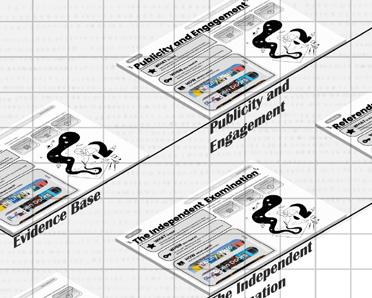
OHTER IDEAS FOR NEIGHBORHOOD PLANNING AND EDITED TEXT CONTENT OF “NEIGHBORHOOD PLANNING ENCYCLOPEDIA” 6.1 Advice & Ideas Other Than Tools Introduced Above 6.2 Roadmap for Neighborhood Planning 6.3 Preparation of Neighborhood Planning 1. A Relevant Body 2. Designation of a Neighborhood Area 3. Designation of a Neighborhood Forum 6.4 Process of Neighborhood Plan 1. Overview of Neighborhood Plan 2. Build Evidence Base 3. Publicity and Engagement 4. Preparing the Plan 5. Pre-submission Consultation 6. Submission 7. The Independent Examination 8. Referendum 9. Plan Made 6.5 Supports for Forums & Community 1. Financial Supports 2. Political & Technical Supports 3. Other Supports 4. Summary * Bibliography
p.60 - 63 p.64 - 65 p.66 - 69 p.70 - 73 p.74 - 81 p.82 - 83
1.1


BEFORE THE LOCALISM ACT 2011

Under the control of the planning system, the development process is as follows:


The LPA is the key decision-maker in the planning system. When a developer has an intention to develop, they need to submit a planning application to the LPA, and the LPA will only grant planning permission to developments that comply with the policies and regulations in the planning system.[3]


The main problems:
But even under this top-down constraint, there are still many developers who seek to circumvent them to obtain permits for short-term gain, to the detriment of local people and threatening local development.

On the other hand, the needs related to local housing, local economy, community facilities and infrastructure are still not being met.[4]
TOP-DOWN APPROACH
AFTER THE LOCALISM ACT 2011
Overview of the act:


The Act is lengthy, extending to over 240 sections, in excess of 20 Schedules and approaching 500 pages. Equally, the Act is broad in its scope. Part I introduces the ‘general power of competence’ under which local authorities are endowed with the ‘power to do anything that individuals generally may do’ provided it is not specifically prohibited.10 The essential idea is that under this novel power local authorities will be free to work with others in creative ways to reduce costs and, it is envisaged, meet local people’s needs more innovatively.


The Neighbourhood Planning:
NEIGHBORHOOD PLANNING IS A


TOP-DOWN APPROACH


DUMMY
DUMMY DUMMY
The central government has long hoarded and centralized power in the areas of planning and construction. Profit-oriented extractive development, in cooperation with external developers, a series of serious problems such as economic exploitation, racial inequality, gentrification, social cleansing and climate crisis affect people’s lives. The impact of social security cuts, housing market pressures and reduced local government funding has forced the state to throw more responsibility back to local governments, expecting people to solve problems through their own democratic cooperation and participation. Ideally, the Localism Act 2011 empowers residents to develop their communities’ future potential and meet their needs autonomously through Neighborhood Planning. On the one hand, it sets a new framework of policy restrictions for bad developers through the Neeighborhood Plan, and on the other hand, through the Neeighborhood Development Order, it gives the community the potential to be an internal developer and develops itself in a simpler and more efficient process.

However, on the one hand, differences in factors such as education, income, and social background lead to community planning that is not available to all, and a large number of people at the bottom are not yet involved, which may help exacerbate inequality. Studies have shown that the rise in homelessness in the UK after LA 2011 illustrates the disadvantage of localist policymaking to marginalized groups in society. [2] On the other hand, the state has delegated “services” to municipalities and regional groups, but it is usually only a cost diversion rather than a real decentralization of power and financial autonomy, that is, responsibility is decentralized, not money for the performance of its duties. In the absence of sufficiently sustainable financial and technical support, existing neighborhood planning organizations have too many responsibilities while volunteering; lengthy bureaucratic interactions with local planning departments have prevented community programs from getting really effective help; even the quality of the completed Neeighborhood Plan is so far from the same that without real financial resources and official support, all the content written in the Neeighborhood Plan can only be a beautiful fantasy of the people of the region Once back to the traditional development model, external developers can still use their wealth of experience to urgently extract benefits from within the community. Especially in the context of London’s huge, complex and unfair urban development, the big hands from all sides make neighborhood planning like a Dummy.
Therefore, we need to expose the unequal development of neighborhood planning in the context of power and resources and further exploration of neighborhood planning that can help shape a better democratic life for the future.
Neighbourhood planning is one of the community rights granted by the 2011 Localism Act.[5] Fundamental changes to the planning system are provded for under Part VI including the abolition of regional strategies, the introduction of neighbourhood plans and neighbourhood devel- opment orders, community right to build, the new homes bonus and reform of the community infrastructure levy.They can increase housing supply, improve the quality of developments and better cater to local needs – those of young families starting out, for example, or older people wanting to downsize.[6]
How Neighbourhood Planning can achive the community right:

Local people can exercise their right to participate in local development by producing their Neighbourhood Plans and Neighbourhood Development Orders.


Neighbourhood Plans and Neighbourhood Development Orders like the weapons for community. Neighbourhood plan for political framework to further constrain developers. Neighbourhood Development Orders can eliminate the process of development application, allowing for rapid development.
BOTTOM-UP APPROACH

6 AA Landcape Urbanism 2021 - 2022 AA Landcape Urbanism 2021 - 2022 0.0 The Voice
1.1 Context Charpter 0 - Neighborhood Planning in London
Central Government Planning policies Strategic plan Local plan Local Development Local Planning Authority “The development process in local.”
Central Government Planning policies Strategic
Local plan Neighbourhood plan Community engagement Planning support Local Development Local Planning Authority Local People Local Relevant Body Local Stakeholders
New Power for the people”
plan
“The
*
Research: Guang Yang, Hantang Li, Siqi Sun, Jiacheng Sun | Content: Guang Yang, Siqi Sun | Drawings: Siqi Sun, Hantang Li
“The Complexity of Neighborhood Planning”[1]
1.2 OVERALL TAKE-UP OF NEIGHBOURHOOD PLANNING IN NUMBERS
The Localism Act introduced ‘a new right for communities to draw up a neighbourhood plan.’ This means that communities in England are not legally required to produce a plan, but it gives them the choice whether to produce one or not. Given this voluntary nature of neighbourhood planning, without resourcing to ensure that all communities have the time and means to participate and create a plan, access to this right could be unequal, and reserved for only select communities with existing knowledge and funding to draw up their own plan.
As in the studies of the overall development of take-up of NPing is biased towards parished, rural areas. There is activity in all region of England, although 18% of LPAs are completely without Neighbourhood Planning activity. There are higher levels of take-up in some areas, notably the South East and South West, and with correspondingly weaker take-up elsewhere, particularly in the North East and London.[8]
The vast majority are led by Parish / Town Councils[9]:


• 91.5% of area designations were led by Parish/Town Councils and 8.5% were Forum-led
• 94.3% of “made” Plans were led by a Parish/Town Council and 5.6% were Forum led.
• 58 LPAs have no neighbourhood planning activity (no designated areas) - 18%
• There are 22 business-led neighbourhood plans: 20 of which were Forum-led.
• Less than 10% of designated neighbourhood areas are Forum-led (i.e. unparished and predominantly urban) and the majority of the LPAs with no NP activity are located in urban areas.

• 2612 areas are designated and can or have progressed Neighbourhood Plans; 9 were revising a “made” neighbourhood plan

• 865 of the total have been “made” and a further 16 have passed referendum (34%)
• 9 neighbourhood plans have failed examination, 6 failed referendum, 1 has been quashed in the High Court and a further 8 have formally withdrawn from the process.

8 “England
AA Landcape Urbanism 2021 - 2022 AA Landcape Urbanism 2021 - 2022 1.2 An Overview of Neighborhood Planning in the UK 1.2 An Overview of Neighborhood Planning in the UK Charpter 1 - Neighborhood Planning in London
& London Neighbourhood Planning Distribution”[7]
Research: Guang Yang, Hantang Li, Siqi Sun, Jiacheng Sun | Content: Guang Yang | Drawings: Hantang Li, Guang Yang
“Neighbourhood Planning Progress & Proportion in England”[10]

1.3


LONDON IS DIFFERENT
Eleven years after the promulgation of the Localism Act in 2011, England has so far designated more than 2,600 Neighborhood Areas and nearly 1,000 neighbourhood plans, but London is seriously behind the country in implementing the Neighbourhood planning. We can see that although London accounts for 16% of the total population of England, it is only 3% of the plans that have been made.[11]

First, we can see that the vast majority of neighbourhood plans in the rest of England are set by established parish or town councils, while London has only one Queen’s Park Community Council. At the same time, London’s complex administrative structure and 3-level development plan system have also forced communities to implement the neighbourhood plan in the form of a forum. At the same time Neighbourhood Planning is a long term process, making it harder for people to participate in a plan that takes three to four years or more due to the frequent population changes in London.
It also seems to represent the potential for London to truly develop and be led by the people compared to other regions, but it’s still out of reach for London residents. We began to try to analyze and study existing community planning in London, to try to find deeper information on this kind of problem in London.


Charpter 1 - Neighborhood Planning in London

10 AA Landcape Urbanism 2021 - 2022 AA Landcape Urbanism 2021 - 2022 1.3
1.3
The Struggles of Neighborhood Planning in London - London is Different -
The Struggles of Neighborhood Planning in London - London is Different -
| Content:
| Drawings:
Research: Guang Yang, Hantang Li, Siqi Sun, Jiacheng Sun
Guang Yang
Guang Yang
TYPE 1: GREEN AND INFRASTRUCTURE (GI)


In the Neighborhood Plan, Residents’ desire for infrastructure, including better transportation facilities, parking spaces, and more bicycle lanes. as well as specific needs for green space and the environment within the neighbourhood (often requiring more or protection of existing spaces, expectations to address noise and air pollution, and constraints on future developers, such as guarantees of green rates in future development areas and while participating). We combine the green and infrastructure requirements in the Neighborhood Plan based on the fact that both are requirements and defining frameworks for the development of physical space within the Neighborhood Area.


TYPE 3: SERVICES AND FACILITIES (SF)

TYPE 2: HERITAGE AND HOUSING (HH)


and social welfare housing or expect a unified architectural style (focusing definition of colors, windows, facades, etc.)


THE RANKING SYSTEM


In

How we score:

TYPE 4: BUSINESS AND EMPLOYMENT (BE)
13 12 AA Landcape Urbanism 2021 - 2022 AA Landcape Urbanism 2021 - 2022
Charpter 1 - Neighborhood Planning in London
1.3 The Struggles of Neighborhood Planning in London - The 4 Types of Neighborhood Plan in London1.3 The Struggles of Neighborhood Planning in London - The 4 Types of Neighborhood Plan in London -
“Neighborhood
Planning Stage for each Neighborhood Areas and the Corresponding Type Ranking List”[12]
an attempt to quantify the propensity to implement neighborhood plans in each NA area, extensive reading and analysis of neighborhood plans was conducted. We pre-set four scoring items for key content that often appear in NP, namely GI: Green and Infrastructure, HH: Residential and Heritage, SF: Services and Facilities, and BE: Business and Employment.
In each scoring content, we collect, evaluate and score through various channels such as the homepage of the neighborhood forum in each NA area, social media, neighborhood plan manuscripts, and meeting minutes published by the neighborhood forum. The score is 1 (lowest level) to 5 (highest priority)
on housing issues and
This type focuses
architectural issues in the Neighborhood Area. There are usually divided into two parts in the Neighborhood Plan: the requirements for residential housing and the protection of cultural heritage in the community, and the detailed provisions in the plan usually include requirements for more affordable and affordable housing (It usually exists in communities with a more modest economy), balance the proportion of private residential development
@Church Street Regeneration[14]
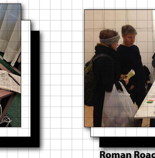
@Roman Road Bow Neighborhood Plan & Social Media from Norwood Planning[13]
lighting facilities and increase the number of schools. At the same time, in the Neighborhood Plan, there are existing problems in the community but no specific solutions can be proposed, including community safety, crime rate, youth drug problems, etc.
The Neighborhood Plan focuses on the needs of the community, including but not limited to providing medical and health facilities in the community, elderly-friendly services, more children’s play spaces, a certain street needs more nighttime
@Roman Road Trust & Healthy Tooting[15]
The part of the Neighborhood Plan on promoting economic development usually refers to supporting local enterprises, developing retail or specialty industries within the community, and hoping to achieve the purpose of increasing tourism revenue through some kind of development project. At the same time, only part of the plan will mention the local employment rate, but usually a specific solution cannot be proposed within the Neighborhood Plan.
Research: Siqi Sun, Hantang Li, Jiacheng Sun | Content: Hantang Li, Guang Yang
@Neighborhood
Plan and Social Media for Drummond Street [16]
Take the Beddington North Neighbourhood Area, for example, especially for Neighbourhood Planning in the draft stage, which includes ambitious green and infrastructure road remodeling plans for the community’s internal roads, including additional green belts and pedestrian-friendly bike paths.


1.3 The Struggles of Neighborhood Planning in London - Typical Solution of 4 Types of Demands -


TYPICAL
At the same time, we further analyzed and collated typical strategies and design approaches to the most important goals and problems in different types of community planning. In this way, we explore the potential relationship between the content of the plan and the universal needs.

1.3 The Struggles of Neighborhood Planning in London - K-Means Clustering Machine Learning Analysis with different factors of London -


Most Neighbourhood Forums do not have a strong ability to influence large scale businesses and the Neighbourhood Plan focuses more on local retail and small businesses to compensate for local employment. The design of the high street therefore tends to control the overall appearance in the document and to provide more commercial services: small street level gathering places, urban furniture etc.

MEASUREMENT


The score value (GI, HH, SF, BE) is presented as a positive integer from 1 to 5. In order to measure the propensity of each item in the corresponding Neighborhood Forum in a single Neighborhood Plan, the four items are scored. The value with the highest value is extracted separately to give 1 as the tendency direction of the main neighborhood plan of Neighborhood Forum, and the percentage of the remaining three values in the sum of the three items is the quantification of the tendency of the remaining three values in the neighborhood plan.


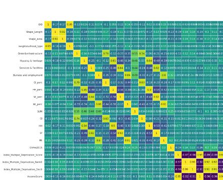
Using the kmeans algorithm to compare the four type of scores of each Neighborhood Area, Neighborhood Forum and Neighborhood Plan in the early stage with the corresponding area’s Income and Index of Multiple Deprivation (IMD): determined by comprehensive indicators such as education, income, environment, etc. correspond. As the numerical output of the plane coordinate system, the two indices are expected to be found in the final output image. Whether the four scores we quantified and local conditions (education, environment, income, population, crime, etc. indices and rank) show a clear correlation (positive correlation and sub-correlation)


14 AA Landcape Urbanism 2021 - 2022 AA Landcape Urbanism 2021 - 2022
Charpter 1 - Neighborhood Planning in London
The Church Street project[19]: for the renovation of the traditional residential area, the Neighbourhood Plan provides for a controlled ratio of social housing to price controlled social development in the future. Further details on the development of the neighbourhood are provided in the Neighbourhood Development Document, which sets out specific information on the appearance of new developments, floor area ratios and other indicators.
BEDDINGTON NORTH NEIGHBOURHOOD AREA BE HH - CHURCHSTREET NEIGHBOURHOOD AREA Church Street Triangle Square Market[21]: As a historic market place and
Neighbourhood Forum is concerned with
space.
Neighbourhood
@Beddington North Neighbourhood Plan @Church Street Neighbourhood Plan[18] @Church Street Neighbourhood Plan[20] @Roman Road Bow Neighbourhood Plan[17] “K-Means for Green and Infrastructre (GI)” “K-Means for Heritage and Housing (HH)” IMD INCOME INCOME IMD “K-Means for Services and Facilities (SF)” “K-Means for Business and Employment (BE)” INCOME INCOME IMD IMD
Settings in Python”
SOLUTIONS GI -
a local cultural icon, the
the maintenance of this part of the
It is hoped that the local market will develop further, and therefore the
Forum’s detailed project document refers to a project to renovate the space for community services in order to be able to provide better services and facilities from the community for the local market. SF - CHURCHSTREET NEIGHBOURHOOD AREA
“K-Means
Research: Siqi Sun, Hantang Li, Guang Yang, Jiacheng Sun | Content: Guang Yang, Hantang Li | Drawings: Hantang Li
K-MEANS CLUSTERING


SPATIAL VISUALIZATION


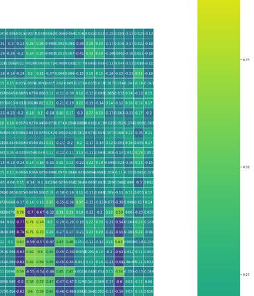
Moreover, the dataset files of the original running system are combined to establish the range of values under each heading. Through Grasshopper K-Means, the existing neighbourhoods in London are visually distributed in the clustering. Mapping and classification of clustering in the coordinate system for each Neighborhood Area. The diagram shows the clustering and classification of Neighborhood Area in the coordinate system for each list with similar values But we found that the classification relationship of the computer-calculated neighborhood plan’s clustering was far from the four different categories of clustering we preset.


EXPLORE RELATIONSHIPS BETWEEN DIFFERENT FACTORS AND TYPES
In order to be more able to confirm the correlation between the neighborhood planning tendency of each community and the various values in the IMD multiple deprivation index, we used Matrix to visualize the gis export csv table. It can be found from the figure that the correlation between the overall neighborhood plan score and the various values in the IMD is weak, and the value fluctuates between 0.25 and -0.25.


This further proves that the content of neighborhood plans is not entirely related to the ability of the community to be rich or poor. In addition to the obvious positive correlation between the community with environmental problems and the plan preferrence of “Green & Infrastructure”, other influencing factors cannot completely determine the plan content and degree of the neighborhood planning.
17 16
1.3 The Struggles of
Planning in London AA Landcape Urbanism 2021 - 2022 1.3 The Struggles of
in London - Correlation Matrix Analysis of Development Factors in LondonCharpter 1 - Neighborhood Planning in London
Neighborhood
Neighborhood Planning
“Correlation Matrix of Multi-Factors and 4 Types of
in
“Clustering for 8 Types” “Clustering Test” “IMD Input Settings” Research: Guang Yang, Hantang Li | Content: Guang Yang, Hantang Li | Drawings: Guang Yang, Hantang Li
Neighborhood Plan
London”[22]


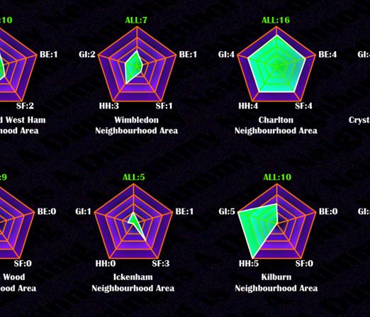


18 Charpter 1 - Neighborhood Planning in London AA Landcape Urbanism 2021 - 2022 AA Landcape Urbanism 2021 - 2022 1.3 The Struggles of Neighborhood Planning in London - Scoring Of All Neighbrohood Plans in London1.3 The Struggles of Neighborhood Planning in London - Scoring Of All Neighbrohood Plans in London“Scoring For All Neighborhood Plans In Terms of 4 Types” RANKING ALL NEIGHBORHOOD AREAS IN LONDON Through a combination of the above research methods, we reassessed and ranked all draft, onging and completed London’s Neighborhood Plans. Further cross-contrast the four different developmental types involved in each plan, and record its overall developmental degree and emphasis on a certain type. Research: Siqi Sun, Hantang Li, Jiacheng Sun | Drawings: Guang Yang | Content: Guang Yang
INTERVIEW PROGRESS


Purpose: We contacted Neighborhood Forums at different stages and with different basic community conditions to conduct interviews to collect the most pressing and real needs of people in different neighborhoods and different neighborhood planning stages (focusing on the part where people participate).


Scope: Fortunately, most of the communities we contacted were very interested in our proposal, and they also wanted a better engagement tool for residents. However, different demands lead to different demand for tools in each neighborhood forum, including the expectation of better translation of text to lower the threshold for dissemination of draft neighborhood plans (Roman Road Forum), and public consultation on specific upcoming projects. Vote & Suggest (Lee Forum) etc.


20 AA Landcape Urbanism 2021 - 2022
AA Landcape Urbanism 2021 - 2022
1.3 The Struggles of Neighborhood Planning in London - Interview with Neighborhood ForumsCharpter 1 - Neighborhood Planning in London
1.3
The Struggles of Neighborhood Planning in London - Interview with Neighborhood Forums -
“Interviewed Several
[23] Research: Guang Yang, Siqi Sun, Hantang Li, Jiacheng Sun | Content: Guang Yang, Siqi Sun | Drawings: Hantang Li
Neighborhood Areas ”
CHAOTIC DEVELOPMENT

Ideally, neighbourhood planning should provide self-protection for local residents within the framework of policies. Within the framework of democratized decision-making, through neighborhood programs, people shape the future of their communities according to their own will. However, in the previous analysis and research, we found that the basic attributes and outcomes of urban development are not directly equivalent to the results of “excellent” neighborhood planning, and there is a huge gap in the content of the neighborhood plan development process between communities, which can be seen in the four scoring criteria of the neighborhood plan (green infrastructure, housing heritage, services and facilities, and commercial employment). At the same time, in the process of communication between the members of the various neighborhood forum organizations, the relevant personnel further showed us the inequalities and difficulties of neighborhood planning and development.
London’s Neighborhood Planning has been manipulated as a “Dummy” for a long time. On the one hand, the Government has delegated “services” to local authorities and regional communities, but it is often just a cost shift rather than a real dispersion of power and fiscal autonomy. On the other hand, due to differences in education, income, social background and other factors, neighborhood planning is not available to everyone. And a large number of people at the bottom have not yet participated. Even if someone were able to get involved, the consequence would be far from the same.
However, the true effectiveness of neighborhood planning cannot be simply defined by a single factor of wealth or poverty, education, or other factors, and inequality can be exacerbated or reduced by subtle interrelationships. Therefore, we have tried to summarize the factors and influencing factors that can play a role in neighborhood planning and proposed a dynamic input model. And by showing the problems and situations in different neighborhood planning stages to assist in demonstrating this dynamic model and understanding the development of inequalities in neighborhood planning.


Basic attributes (fixed attributes) influence to some extent the quantity and quality of the type of costs that can be invested. The quality and variety of the costs invested will influence the conversion rate of each action (dynamic input, consisting of three aspects: the amount of money the community invests in the project, the time it is willing to spend and the level of public participation). A forum with good basic attributes can afford to invest quality costs to achieve the desired results. A forum with poor basic attributes, on the other hand, has a limited quality and variety of costs to invest, and therefore the end result is a poorly protected and developed community. This ultimately determines the different development-preservation forms of the forum. Bridging the financial and technical gaps, saving time and increasing the level of community engagement is a potential way forward to bridge the existing Neighbourhood Planning without changing the basic attributes inherent in the community.


However, the inequality of neighborhood planning is more prominent due to the large disparities in the underlying attributes of different communities, and we will further demonstrate this issue based on interviews and reports at each neighborhood planning stage.


23 AA Landcape Urbanism 2021 - 2022 2.1 Dummy & Opportunity
22 Charpter 2 - Inequalities Found in Neighbourhood Planning AA Landcape Urbanism 2021 - 2022 2.2 Dynamic Model
Neighbourhood Plans in different forums reflect different levels of protection and capacity for autonomous development. These capacities are determined by their own conditions (basic attributes), including the average income of the local population, the average level of education, the level of enthusiasm for the Neighbourhood Plan, social power, political status and ethnic diversity, etc.
2.2 BASIC ATTRIBUTES & DYNAMIC INPUT “Poor Community with Low Basic Attributes” “Rich Community with High Basic Attributes” “Accessibility Of Neighborhood Planning Tools By Index Of Multiple Deprivation And Previous Research”[24] Research: Siqi Sun, Guang Yang, Hantang Li, Jiacheng Sun | Content: Siqi Sun, Guang Yang | Drawings: Siqi Sun, Hantang Li
2.3 DIFFERENT ATTITUDES OF THE


OFFICIAL AND RECORDS
Building a strong relationship with the local council could be an opportunity. The third of neighborhood plans are in the borough, confirms Roger Winfield, chair of the Kentish Town Neighborhood Forum, who has been very helpful from his borhood planning’.[27]
THE BEGINNING OF THE DIFFICULTY

Support from the councils varied. Most members were negative about their relationship with the local council. This was mentioned by the chair of the LEE community when we spoke to her, and the Grove Park Forum fought against Lewisham Council for a considerable period of time. Stephen Kenny, Chair of the Grove Park Forum, said that Lewisham Council had prevented the Grove Park Forum from receiving an extra £50,000 to become a ‘front runner’ (A small number of forums received additional funding to be ‘frontrunners’ to encourage early designation) to encourage the designation of neighborhood forums and developments.[28]
The last type is the ‘Desert Area’, where the local council issues little or no information and advice on the neighborhood plan.


In the course of our interviews we further confirmed that the help given by different councils and local planning authorities is completely different. Even in a generally bureaucratic and lengthy process, the feedback from the Westminster area was most positive, whereas a Forum such as LEE, which spans two different Boroughs, Levisham and Greenwich, is quite difficult to receive active and prompt help from government departments.
if they are less enthusiastic about neighborhood planning. “The third type of municipality is the ‘Conforming Authorities’. The third type of municipality is the ‘Interventionist & resistant authorities’, which place additional hurdles and criteria on top of the normal application criteria for resident community groups, requiring them to provide information that goes well beyond the legally specified criteria.


As we mentioned in the previous chapters, we can see that the vast majority of Neighborhood Planning in the rest of England is made by established parish or town councils, whereas London has only one Queen’s Park Coummunity Council. small towns and villages have distinct boundaries, usually determined by the boundaries of the parish councils in the area. The designation of neighborhood planning areas is therefore relatively straightforward. In contrast, London is a large and complex urban area where ‘relevant bodies’ with common needs may simultaneously cross local authority boundaries in a dispersed and fluid manner, making neighborhood planning areas more difficult to form.
This difference can also be partly attributed to London’s local government structure, with the Borough nestled between the Neighborhood Forum and the Greater London Authority. This can create new challenges when forming neighborhood forums and boroughs, and in ongoing planned developments. The complexity of London’s communities means that in London, each borough will contain several different communities, and communities can often cross borough boundaries.[31]


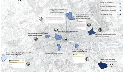
In addition, the Neighborhood Area designation shows that in two areas, Marylebone and Pimlico, there are phenomena worthy of consideration. In these two areas we can clearly see a clear boundary created by the superimposition of different conditions. Marylebone and Pimlico, which should have been designated as a neighborhood as a whole, have been divided into the Marylebone neighborhood Area and the Church Street neighborhood Area, and the Pimlico neighborhood Area and the These less favourable areas were excluded from the “good” plan at the outset.
Councils are limited by funds and planning officers may not have the necessary knowledge.[29] Brian O’Donnell emphasized the importance of maintaining a strong relationship with forums in Camden. He explained that one reason for limited support from some Councils is that they often have limited resources themselves, with small planning policy teams, and that support they provide to neighbourhood planning draws resources away from other areas. Councils receive no dedicated funding for Neighbourhood Planning yet are liable for the costs of running referendums and examinations of the plans. In addition to limited funding, Stephen Kenny said, ‘planning committees do not have the knowledge. There needs to be an evidence based education for them so that they can make informed decisions especially after a general election when a planning committee member with absolutely no knowledge whatsoever about planning, is being led by an offi
The second type of municipality is known as ‘Conforming Authorities’, which provide ‘Conforming’ information about neighborhood planning on their websites, even officer whose mandate is about compensation…’


25 AA Landcape Urbanism 2021 - 2022 2.3 Evidence & Discussion - Supports from Borough & LPA -
24
Charpter 2 - Inequalities Found in Neighbourhood Planning AA Landcape Urbanism 2021 - 2022 2.3 Evidence & Discussion - Stage of
of Neighborhood Area -
Designation
“Recordings of Feedback from Neighborhood Forums”
CHURCHILL GARDENS
CHURCH STREET
“4 Type of Attitudes of Local Authorities”[25] Active Supporters Conforming Authorities Active Supporters Interventionist & resistant authorities Desert Area Conforming Research: Guang Yang, Siqi Sun, Hantang Li, Jiacheng Sun | Content: Jiacheng Sun, Guang Yang | Drawings: Jiacheng Sun
“Pimlico and Marylebone Witnessed Unequal Neighborhood Area Designation”[30]
DIFFICULT TO BUILD THE COLLECTIVE


In the second phase of Neighborhood Planning, people also face different problems. London’s cultural and demographic diversity also provides significant challenges for Neighborhood Planning. Overall, London has a higher proportion of renters than the rest of the UK, which tends to result in a more transient population, making it more difficult for people to engage in plan-making that takes four or more years.[34]


However, it is worth noting that Neighborhood Forums have been designated and community plans completed in many different locations, both geographically and economically.


The difficulty of establishing NFs is also linked to the aforementioned level of support from the LPA, whose rejection of local NF proposals has led to the aspirations of an emerging forum being crushed at the first step, and these communities without established NFs are referred to as ‘orphan communities’. Orphan area designations are often the result of disputes between the forum and the designating body, or between local groups. A great deal of time and effort is wasted. In most of the above cases, it seems clear that the local authorities would like to see the designation rejected and that no neighbourhood plan should be implemented.[35]


Yet another complication is the reaction of an area to the creation of a forum in a neighborhood: “There are other forums in my ward, so we have to have one, don’t we?” It is therefore argued that the threat posed by neighbouring communities developing policies that may affect other districts has led to reactive action by neighbouring districts. Each designated community area can only generate one community plan and forum. The ability of the forum to cross the fi hampered by the fact that local authorities are placed in a difficult and time-consuming mediation role due to competing applications from different groups with overlapping geographical boundaries.[36]
It is reported that those interested in holding a neighborhood forum under the new system were clustered in the city centre, with 46% of people in the boroughs of Westminster and Camden expressing interest in setting up a community forum to date. Many reasons can explain this concentration of interest and activity. Boroughs that have historically had a large number of civic and amenity societies, and those with established experience of supporting these groups, may be better placed to respond to neighborhood planning applications.[37]


Evidence & Discussion


- Stage of Designation of Neighborhood Forum -


At the same time, it is important to have a clear and visionary constitution for the future maintenance of the forum at the time of the neighborhood forum designation. Choosing the right type of legal structure for the forum will also play an important role in the future use of community funds, the application of grants and the operation of the membership.
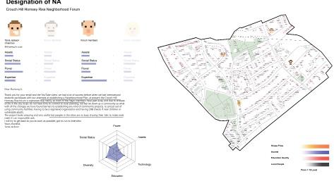
However, while the ‘average’ neighborhoods are still struggling to meet the basic requirements for a neighborhood forum, the ‘good’ neighborhoods have already made a fantastic start to the future of their neighborhoods. As we can see, in Belgravia, the committee members of the forum are the elite from all walks of life, whose work and place of residence undoubtedly places them at the very centre of power in the area, and who make the most of the potential diversity and capability of the neighborhood forum. In contrast, in the Crouch Hill and Hornsey Rise neighborhood Forum, the instability brought about by the initial membership and the constitution, along with the death of many of the area’s leading members after the epidemic, led to the complete stagnation of the entire forum and its dissolution
“Comparison of Neighborhood Forum Member and Basic Attributes”


26 AA Landcape Urbanism 2021 - 2022 2.3 Evidence & Discussion - Stage of Designation of Neighborhood Forum -
AA Landcape Urbanism 2021 - 2022
2.3
Charpter 2 -
Found in Neighbourhood Planning
Inequalities
“UK Living Price Distribution”[32] Research: Guang Yang, Siqi Sun, Hantang Li, Jiacheng Sun | Content: Jiacheng Sun, Guang Yang | Drawings: Jiacheng Sun, Siqi Sun
“Active Boroughs based on Population Density”[33] “Constitution of Neighborhood Forums”
ENGAGEMENT) ARE AFFECTED


In the early days of Neighborhood Planning, for the average neighborhood community. Lengthy and bureaucratic interactions with local planning authorities, occasional humanitarian help from technical members of local professional bodies and forums, allow site information to be professionally collected and fed back in years. For example, the Westbourne Neighborhood Forum, they are about to start a evidence-based review, but the information used is still a resident survey collected 5 years ago. In contrast, the “successful” Marylebone community hired professionals from different fields to identify problems in the region through the perfect use of Community Infrastructure Levy(CIL), efficiently and quickly achieving the desired results.


Only communities that are “trusted” by local agencies can get CIL amounts that can really help at any stage. The truth is, when you’re still being rejected or reducing the amount of CIL for a community meeting, other forums are already getting a large amount of CIL for


CONTROL OF RESOURCES AND POWER


Community Infrastructure Levy (CIL) is a levy developed for new infrastructure to help address this need In most parts of England, local parishes can decide how they spend their money, and if they have a neighborhood plan they can get 25% up to 15%. If they don’t, they encourage parishes to develop a scheme levy part of which must be spent on the communities they collect.[39]
At the same time, however, the Community Infrastructure Levy arrangement remains a controversial issue locally, in some areas. As many local conservation areas do not have a CIL schedule, it does not benefit or act as an incentive for many community planning areas. Instead, in one case ‘too much’ money went to a community (by their own admission), even though the area was not obliged to accept it. Although there are some cases where CIL has provided significant amounts of money to communities, the vast majority of community questionnaire respondents (84%) indicated that CIL was either not an incentive or did not apply to their situation because they had not allocated land for development to generate CIL income.[40]
Planning Aid for London (PLA) said that some of the [Neighborhood Planning Applications] being undertaken in Camden could take up to three years and that it would cost between £80,000 and £100,000 to produce them.[41] At the end of the process, a referendum would be held - a Queen’s Park Parish Council referendum, the size of a community, at a cost of £23,000 Cost implications are significant. If all the community forums were to reach the final stage, plus the cost of salaries for “at least a small number of planners” over the next few years, Westminster alone would face a referendum bill of £500,000. So funding is very limited.[42]


Funding conditions are too rigid, and availability of additional funding is variable. Jane Briginshaw said the new criteria made it harder to secure grant funding, ‘Because of this new business about what you can spend it on, we have to contort ourselves.[43] Some forums also successfully secured funding beyond the government grants (between £9,000 and £17,000). For example, the Greater Carpenters forum secured grants from Trust for London, Loretta Lees, London Tenants Federation and UCL’s Engineering Exchange.[44] However, availability of additional funding can vary, and the process of seeking it can be time consuming. Jane Briginshaw had ten meetings with Wandsworth Council to seek the 2,000 shortfall that her forum needed but had no success.[45]

29 AA Landcape Urbanism 2021 - 2022 2.3 Evidence & Discussion - Stage of Evidence Review -
28 AA Landcape Urbanism 2021 - 2022 2.3 Evidence
LevyCharpter 2 - Inequalities Found in Neighbourhood Planning
& Discussion - The Usage of Community Infrasturcture
[38]
| Content:
| Drawings: Guang Yang
Research: Guang Yang, Siqi Sun, Hantang Li, Jiacheng Sun
Jiacheng Sun, Guang Yang
SIMILAR CONTENT DOES NOT REPRESENT THE SAME FUTURE
The Neighborhood Plans of the different forums reflect different levels of protection and self-development.
1. Lee’s plan is more idealistic in that it identifies the specific roadways and locations that it wants to enhance and provides solutions, which is more targeted and has a more realistic and effective protection; and it has already started the design of the first development project.
2. In contrast, the Highgate plan only specifies a general area and sets out development restrictions, without specific proposals for specific sites and areas.
3. Roman road has a specific development policy and project plan, but no funding to bring it to fruition.
DISCUSS POTENTIAL AND THE FUTURE


Through a longitudinal study of the entire process of neighborhood planning, as well as a horizontal comparison of the basic attributes and dynamic inputs between neighborhood forums at the same stage. We have a deeper understanding and appreciation of how neighborhood planning, so-called “new power of the people,” continues to exacerbate inequalities in urban development. As mentioned earlier in this section, in the process of developing neighborhood planning, the key factors that determine the ultimate quality of neighborhood planning are the basic properties of the place and the dynamic input. Communities with high social status, more power and resources, and highly educated residents have easy access to financial and technical support from governments and institutions. Conversely, marginalized community groups with few resources and incomes struggle to exercise what is known as the “right to bottom-up development”.


In a situation where innate local fundamentals cannot be easily changed, the time cost spent, the level of community engagement, and the amount of funding and technical support obtained are the only potential research directions that can reduce the obstacles that disadvantaged communities encounter in exercising power and chasing their dreams.
In the following chapters, we will give our views and suggestions on how to improve the results of neighborhood planning.
2.4 THE DESIRED OBJECTIVES

The goal is to focus on the future of communities that can help the weak and small with different underlying attributes and to continue to develop indigenous bottom-up communities efficiently and freely. Time, funding technology and community engagement related issues are the most direct and effective help. We have gradually summarized the following main tasks:
Objective 1. How to convert professional and complex planning information into a simple and easy-to-understand form for non-professional auditors in NF through a certain platform or facility, so that they can be more autonomous without the frequent help of LPA officials review these data.


Objective 2. How to convert the simple results of discussions between NF and the masses into professional and complex planning information through a certain platform or facility to LPA’s technical support staff, so that they can have more confidence that the community can produce effective and correct planning solutions.
Objective 3. How to use a certain platform so that the final generated NP can be converted into a version that is easier to understand, so that people who participate in voting can truly understand the future of the community, and at the same time allow more people to participate.


Objective 4. How to reduce the information gap between community residents with different majors, different sources, different education levels and other factors by some means, so that more people can fully and suggestively understand the power they have, and at the same time obtain Wanted information about NP.
Objective 5. How to attract those special groups that are important in the community but generally difficult to cooperate with through a certain software or platform to better communicate with NF
Objective 6, How to let more people understand and participate in neighborhood planning, further expose and expose the inequalities in the development of existing planning, so that people can consciously understand the gaps between small and weak individuals and regions.
Objective 7, How to modify and strengthen the existing neighborhood planning organizational structure from the institutional framework and find a new sustainable development structure.
30 AA Landcape Urbanism 2021 - 2022 2.3 Evidence & Discussion - Contents of Neighborhood Plans -
AA Landcape Urbanism 2021 - 2022 2.4 Visions & Objectives Charpter 2 - Inequalities Found in Neighbourhood Planning
“Comparison of Neighborhood Plans”
“Anatomical Map for Neighborhood Planning in London” Research: Guang Yang, Siqi Sun, Hantang Li, Jiacheng Sun | Content: Guang Yang, Siqi Sun | Drawing: Siqi Sun, Hantang Li
Therefore, to alleviate these situations, we defined the most important objectives, which is “How to enable people from different backgrounds to fully understand individual rights and the forms of their application within the complex professional legal and planning framework, to be able to identify and assemble groups with the same needs and interests, to master the framework of neighborhood planning the and ability to realize the collective vision within. “
After summarizing the documents and framework of neighborhood planning, we made a roadmap that detailed the process of neighborhood planning so that people can clearly find the corresponding steps and structures.


32 AA Landcape Urbanism 2021 - 2022 3.1 Overall Structures AA Landcape Urbanism 2021 - 2022 3.1 Overall Structures Charpter 3 - Neighborhood Planning Encyclopedia 1 2 4 A B 5 7 8 9 10 11 3 6
3.1 FIRST LAYER FOR SIMPLIFYING COMPLEX LEGISLATION “Neighborhood Planning Roadmap” Research: Siqi Sun, Guang Yang | Content: Siqi Sun | Drawing: Siqi Sun
3.2


SECOND LAYER FOR SIMPLIFYING COMPLEX LEGISLATION


Based on the roadmap and other research, we use the Figma platform first developed a “Neighborhood Planning Encyclopedia” to categorize, organize, generalize and recompile all the complex information about neighborhood planning. Through a more convenient and repeatable interactive interface, residents can clearly understand the detailed process within the neighborhood planning framework, the corresponding application forms and technical support, laws and legislation and other effective tools.


At the same time, for minority groups, finding legislation and tools to address demands may be far more effective than engaging in lengthy neighborhood plans. Therefore, they can be quickly located on the page of tools that may be applicable through a simple questionnaire.


34 3.2 Simplification Interface of Complex Legislation Charpter 3 - Neighborhood Planning Encyclopedia AA Landcape Urbanism 2021 - 2022 3.2 Simplification Interface of Complex Legislation
SCAN ME! RECOMMEND USING PC FOR BETTER EXPERIENCE
Drawing: Guang Yang | Content: Guang Yang
For different types of users, we roughly divide the home page into three sections.


The first is “non-professionals,” which primarily serve residents who may know a part of neighborhood planning and have been involved. Those with an understanding of the basics of neighborhood planning can learn more details about NF and NA on the left side of the home page.


The second is “professionals”. In this section, members of the neighborhood forum or relatively professional community members who are very familiar with the internal planning process of the community can easily find information about any stage of neighborhood planning, and get effective and fast help without having to read and search repeatedly tedious planning details.

Finally, there is the “rookies” section, located at the bottom right of the homepage, for residents who are completely ignorant of neighborhood planning and community development. As long as they have community-related needs, they can simply go through a few questionnaires to locate the tools they might need without having to go through the whole tedious details of neighborhood planning.

PROFESSIONALS
In the “Professionals” section, you can first view the details of each step of the neighborhood planning, such as the “Evidence Base” shown on the right. The encyclopedia will explain to you why you need to build an evidence base and its main content constitute. Each subdivision icon can be entered to explore more details. It is important to establish a complete and comprehensive “Evidence Base” in the early stages of neighborhood planning.


At the same time, according to the categories of tools and regulations, we have divided them into four major categories: “Intervention, Protection, Institutional & Financial Tools”, and you can find tools that can help you according to your needs.


NONPROFESSIONALS
For people who are “Non-professionals” but have a certain understanding of neighborhood planning, the establishment of Neighborhood Areas and the formation of Forum Constitution are very important.


Building a long-term, sustainable and diverse forum structure is quite beneficial to the maintenance and community development of the later forum. From here, they can learn how to become or discover a “contributing” community member.

ROOKIES
For those “Rookies”, being able to quickly and easily locate or understand the tools that can solve the problem is most important, and learning the overall content of neighborhood planning and other tedious knowledge is secondary to them. Therefore, they can use this “Magic Quick Questionare” to enter the target tool page by analyzing and classifying their initial intention, ownership and usage status of the target item.


For example, the process on the right shows a scenario:


After the epidemic, many shops in the community are vacant. There is a minority group who have always wanted a venue where they can showcase their community’s cultural and ethnic art, but they didn’t know how to meet this need, so they targeted “Meanwhile Use” by using our “Magic Quick Questionnaire”, that tool might meet their needs.

37 36 Charpter 3 - Neighborhood Planning Encyclopedia AA Landcape Urbanism 2021 - 2022 3.2 Simplification Interface of Complex Legislation AA Landcape Urbanism 2021 - 2022 3.2 Simplification Interface of Complex Legislation
USER INSTRUCTION
NONPROFESSIONALS PROFESSIONALS BY SIMPLE CLICK MORE SUPPORTS STEP 1 BEFORE EVERYTHING ALL STEPS OF NEIGHBORHOOD PLAN HOME PAGE EVERYTHING YOU NEED FOR THE RESEARCH STEP 2 FOR BOUNDARY TO NEXT PAGE 3.3 Detailed Examples CHECK OWNERSHIP CHECK ATTITUDE CHECK AVAILABILITY OR STEP 2 FOR THE SAME VISION SCAN ME! RECOMMEND USING PC FOR BETTER EXPERIENCE
ROOKIES
Research: Guang Yang | Figma: Guang Yang | Content: Guang Yang
“Meanwhile Space” the use of temporary contracts that allow community groups, small businesses or individuals to move into these vacant spaces and set up shop, on the understanding that they will leave within an allotted time.
In 2009, the first central government programme on meanwhile use. It describes a process of “intelligent use of unproductive empty buildings and underused land”; a process which bolsters local liveability by fostering business innovation and experimentation. “Meanwhile Space” approach is distinct in its ethos, in that it encourages low-cost community investment by providing access to cheap floorspace for local small businesses, community care projects and start-ups.
You can start “Meanwhile Use” when you find any of the following elements within the community:


1. Underused Spaces within your community;


2. Certain demands from collective or even individual.
“Meanwhile Use” unlocks underused space for the benefit of community cohesion, placemaking and enterprise. This is typified by finding wasted space, transforming unloved visible, interesting, dilapidated, difficult buildings, into something useful. Beneficiaries include seed and startup development stage businesses that require affordable space with flexible terms and support to thrive (or fail).
Ebury Edge is a temporary work and community space at the heart of Westminster designed in collaboration with Jan Kattein Architects, combining affordable workspace and retail units with a café, a community hall and a public courtyard.

As part of the Ebury Bridge Estate redevelopment, which will see 781 new homes created and existing housing blocks retrofitted just south of London Victoria, Westminster City Council (WCC) was keen to provide the local community with an immediate sign of regeneration.
The project sets a precedent by embracing the creative potential of the regeneration process. By bringing community amenities to the Estate in advance of long-term redevelopment, the scheme provides residents with valuable social spaces to meet and the infrastructure to facilitate local business. The design and consultation approach has resulted in a striking appearance, reflecting residents’ wishes to invite communities old and new into the renewed Estate.
3.3 DETAILED


INTERFACE

For example, they may find that “Meanwhile Use”, a tool for shortterm use of the underutilized space of the community, can meet their needs very well. Through the Neighborhood Planning Encyclopedia, users can quickly understand the specific concepts and legal support of the tool, when it can be used, the ways and experiences of different groups of people, find relevant technical guidance and financial help, and at the same time can access similar legislation and tools to understand and tell the difference.


39 38 Charpter 3 - Neighborhood Planning Encyclopedia AA Landcape Urbanism 2021 - 2022 3.3 Detailed Examples AA Landcape Urbanism 2021 - 2022 3.3 Detailed Examples
“Meanwhile Use”, “Community Asset Transfer” & “Community Right to Reclaim Land” all involve temporary or permanent transfer of ownership of land and premises. So when you find that “Meanwhile Use” doesn’t work for a public land, try the two related to it. BASIC UNDERSTANDING OF EACH TOOL THE SUPPORTS TO ACCESS THIS TOOL RELEVANT OR SIMILAR TOOLS WHAT IS THIS? WHEN YOU NEED IT? CASE STUDIES
You can find the corresponding possible support on each tool’s page.
financial support
most important of all projects, and the “Community Infrastructure Levy” for servicing and community
Borough
previous research
SCAN ME! RECOMMEND USING PC FOR BETTER EXPERIENCE PUBLIC ASSETS OR PRIVATY OWNERSHIP? BASIC UNDERSTANDING OF EACH TOOL RELEVANT OR SIMILAR TOOLS THE SUPPORTS TO ACCESS THIS TOOL Research: Guang Yang | Figma: Guang Yang | Content: Guang Yang
For example,
has always been the
development is almost unknown to most people. Some of the
Councils mentioned in the
are not even willing to show the CIL details to the public.
4.1 THE ULTIMATE FORM OF


AA Landcape Urbanism 2021 - 2022 4.1 Dummy City AA Landcape Urbanism 2021 - 2022 4.1 Dummy City 41 40 Charpter 4 - Dummy City Game Producing: Guang Yang, Siqi Sun, Jiacheng Sun, Hantang Li | Drawing: Jiacheng Sun | Content: Guang Yang
For most non-professionals, the “Neighborhood Planning Encyclopedia” we produced may still be a little technical and difficult to enjoy the process of participation. Hence, after several iterations of testing (find out more in Chapter 6), with an easier and more fun approach to neighborhood planning for more age groups and backgrounds, we’ve developed a board game similar to Cold War, Plague Inc., Power Grid and Monopoly that can help you grab the real context.
COMMUNITY ENGAGEMENT
Educational Techniqual

Among all the knowledge collected and organized on “local development planning,” we have selected three types of knowledge that “ordinary” community residents need to frame in the introductory stage:

Recreational
To add interest, we have selected and combined various systems from different games, including:


Considering the difficulty of getting started with the game and the player’s ability to play, we have selected appropriate technologies to assist in helping players


understand the gameplay and develop relevant knowledge faster. Techniques include.

Finger Tracking


1. Basic urban knowledge; 2. Developmentrelated knowledge; 3. Planning policies and tools.


This knowledge is simplified and integrated into our game board, skill cards, and game rules.


1v1 matchmaking mode in Risk; each plot uses a numerical size comparison to make it easier for players to calculate. ②


Numeral Calculating Project Mapping


Random card selection mode in Auto Chess to reduce players’ over-decision in card selection.


DUMMY CITY


Two players meet in a grid of urban plots of different uses. The objective is to re-develop as many plots as possible for your camp.


A single development is successful if you arrive at the end of the process having accumulated enough “effort points”. You can take actions by spending your budget consolidating your developments, investing in new areas or undermining your opponent’s strategy by “buying away” their “effort points”.
Spread too thinly and you risk systemic failure….. Focus too much and you will be surrounded….


42
①
3D Printing: Guang Yang, Jiacheng Sun | Morphology of Building: Jiacheng Sun | Godot Functionality: Guang Yang, Hantang Li | Godot UI/UX: Guang Yang | Projection Mapping: Guang Yang | Game Design: Guang Yang, Siqi Sun, Jiacheng Sun | Drawing: Siqi Sun | Content: Guang Yang, Siqi Sun AA Landcape Urbanism 2021 - 2022 4.2 Game Introduction Technical Recreational Educational Charpter 4 - Dummy City AA Landcape Urbanism 2021 - 2022 4.3 Functionality Break Down SCAN ME! FOR GAME INTRODUCTION
The Economy and Employment typology represents the community’s solid aspirations for retail, commercial centers, entertainment and recreation, economic transformation, and employment. The Services and Amenities type includes, but is not limited to, providing in the community issues such as health care facilities, senior-friendly services, children’s play spaces, education, and community safety controls


The Housing and Heritage type represents residents’ aspirations for goals such as affordable housing, community benefit housing, community cultural heritage, and architectural style


INTERFERENCE
In reality, there is a process for both developers and community to obtain “ownership” of a “New” building. The game will be simplified as follows: stage1: application; stage2: complementary documents; stage3: settlement. Stage1


SIMPLIFY


45 44 USE CLASSES CLASSIFICATION BY COMMUNITY VISION SERVICE & FACILITIES 27% GREEN & INFRASTRUCTURE 17% BUSINESS & EMPLOYMENT 28% HOUSING & HERITAGE 28% PART A PART B PART C PART D Shops Retail warehouses A1 Shops Offices Research and development of products Light industry appropriate B1 Business Hotels Residential care homes Secure residential Dwelling houses Houses in multiple occupation. Clinics Cinemas Health centres Music and concert halls Crèches Bingo and dance halls Day nurseries Swimming baths Day centres Skating rinks Schools Gymnasiums Art galleries Boarding Hospitals Guest houses Nursing homes Secure residential accommodation Young offenders’ institution Custody centre Use as a prison Detention centre Short term holding centre Secure hospital Boarding schools Residential colleges Training centres C1 Hotels C2 Residential institutions C2A Secure Residential Institutioninstitutions C3 Dwelling houses C4 Houses in multiple occupation. D1 Non-residential institutions D2 Assembly and leisure Financial Professional services Morphology Value 5 4 3 2
The Green and Infrastructure type represents residents’ aspirations for infrastructure, including better transportation facilities, parking and more bike lanes, as well as specific needs for green spaces.
A2 Financial General industrial B2 General industrial Restaurants Cafés A3 Restaurants and cafés Special industrial uses B3-B7 Special industrial uses Public houses Wine bars A4 Drinking establishments Storage or distribution Open air storage B8 Storage or distribution Hot food takeaways A5 Hot food takeaways FROM THE TOWN AND COUNTRY PLANNING (USE CLASSES) ORDER 1987 SCAN ME TO WATCH THE PART OF GAME BOARD AA Landcape Urbanism 2021 - 2022 4.4 How to Link Local context Morphology of Building: Jiacheng Sun | Tutorial Filming: Siqi Sun | Projection Mapping: Guang Yang | Game Design: Guang Yang, Siqi Sun, Jiacheng Sun | Drawing: Siqi Sun | Content: Siqi Sun SERVICE & FACILITIES GREEN & INFRASTRUCTURE BUSINESS & ENTERTAINMENT HOUSING & HERITAGE In Stage1, select the building you want to get the “Ownership” of building, In Stage2, If you still want the “ownership” of the building, you need to complete the remaining amount at this stage. All plots on the game board will automatically progress to the next Stage If the building has enough effort points, If there are not enough effort points, The building will be “owned.” The money invested will be refunded, and the building status will return to “new.” and place the effort point inside then the building
DIFFERENT BUILDINGS HAVE DIFFERENT SCOPES
TERVENTION Use
to
It will return to New status be-
Interference success Community Application Progress PURCHASE PROGRESS IN GAME
Morphology Value Morphology Value Morphology Value
immediately enters Stage1. The developer’s building entered STAGE 2 and made up the final payment. This is a good time for you to hinder your opponent. If your “ongoing” and “completed” buildings have an opponent’s building in their sphere of influence, you can interfere with them. You can move your finger over a building to see the range of influence of the selected building.
OF IN-
one effort point
offset an effort point in the opponent’s building
cause it does not have enough effort points.
PROGRESS IN REALITY
Application
ONGOING Stage2 Stage3 COMPLETED Developer
Progress
IN GAME
SCAN ME TO WATCH THE TUTORIAL OF GAME Technice: Finger Tracking AA Landcape Urbanism 2021 - 2022 4.5 Two Main Operations Charpter 4 - Dummy City
SKILL CARDS CLASSIFICATION
Real people in real communities need help with money and time: to save time in the application process or to have more money to move forward with development. So our skills work around the elements of “money” and “time,” matching real-world policies and tools into the game.


SKILL CARDS CLASSIFICATION BY REALITY
COMMUNITY
The effects of developer skills all correspond to realistic development (behaviors) consequences that developers may have and the impact that behaviors have on communities. Players can learn from them which actions of real developers affect the community and make more rational community development decisions


When the game skill cards correspond to realistic policies and tools, they are divided by the type of help provided. impact.
When the game skill card corresponds to the impact real developers bring to the community, it is divided by the type of


47
and
We have categorized the real-life tools
policies that helpfully help community development and presented them in the table below. The skills in the game correspond precisely to the names of policies and tools in real life, allowing players to use the skills and get more information about how to develop the community.
BUYOUT
EXPERT WEAKENING
PLUNDERING COMMUNISkill Card Design: Guang Yang, Jiacheng Sun | Skill Card UI/UX: Guang Yang, Siqi Sun, Jiacheng Sun Siqi Sun, Guang Yang 46 Planning Authorities
EXPERTS
COMMUNITY
CODE by the type of help provided.
DEVELOPMENT PROGRESS to have HELP PERTS HELP COMMUNITY FUNDING SUPPORT COMMUNITY ASSETS TY ASSETS A Any Any g Levy Level 1 [SR] that Developer had already Levy Level 2 half ‘Complete Effort Point’ you rather than submitting them ‘Section 106 Pool’ of Government. is Continuous Effect, please remember ask Developer give you tokens every time. n (tricks you can change land type of an ongoing project Developer to directly ‘Stage r Completed Engagement Progress ] Any Any Space Stage You can pick ANY ‘1’ ongoing GI/BE of Developer clean ‘Stages’ and New/Ongoing project directly become ‘Stage 2’. Effort Point Projec Projec You can use double(depends on stage) ‘Effort Point’ purchase ‘Completed Project’ or an ‘Ongoing Project’. (Government ‘Effort Points’ back the neighborhood forum. Stage Any Ne g ‘Stage 2’, should immediately pay the rest ‘Effort Point’. not, will fail. [SR you already have at least ‘Completed BE’ located on diagonal line, you can relocate the New/Ongoing/ Completed project between them any place you want. Point’ projects within the ‘Affecting Zone’ Point’ for each Neighborhood Forum’s project within your ‘Affect Zone’. HH areas. (for new project you need at least purchase ‘Effort Point’) Ne New 4.6 Skill Cards | Content: Rough Neighborhood Plan [N] You can desinate any NEW/Ongoing project directly becoming ‘Stage 2’. Any Any or or Example New Stage 1 Stage 2 Stage 2 Meanwhile Use [N] BE or Stage ? You can pick ANY ‘1’ ongoing GI/BE of Developer to clean all ‘Stages’ and give ‘Effort Point’ back to Developer. Stage ? NEW - BE NEW - GI or Example Miracles ‘heard’ from Local Planning Authoritie s [SSR] You can desinate a 2*2 grid of land to get maximun ‘Effort Point’ of them from LPA. Example New GI New BE Stage1 SF Stage2 HH Stage1 SF Stage1 GI Stage2 HH Stage1 BE Technical Support from A A [N] You can desinate any NEW/Ongoing project getting + 3 ‘Effort Point’. Any Example Stage ? Any Stage ? COMMUNITY Technical support from any professional organization is very important for neighborhood planning, so the more technical support, the faster the progress of local neighborhood planning. By using Meanwhile Use on commercial community land, it can help build better community services and common interests and create community value. At the same time, it can also alleviate the frequent development of vacant spaces within the community by developers. This is just a good wish, if every LPA and Bourough Council can spare no effort to help the community build neighborhood planning, then people can really achieve democratic bottom-up development, but the reality is that they will only leave the responsibility and task to the masses . A simple and effective neighborhood plan can already provide a certain degree of protection for the future of the community. However, please pursue the most complete and comprehensive neighborhood plan. The developers have useful and rich experience to bypass most restrictions. Please be patient and improve your plan. FINANCIAL HELP AUTHORITY SUPPORT EXPERT HELP AA Landcape Urbanism 2021 - 2022 4.6 Skill Cards Charpter 4 - Dummy City
be less exploited and plundered by foreign developers, it can also allow more residents to realize their common aspirations, and it can also build a better living land for the next generation.
Community Infrastructure Levy, which has been largely unknown to the general public, is one of the biggest sources of income for residents to fight against bad developers. In richer areas, the CIL brought by development projects is correspondingly higher, and residents in ordinary or poor areas should learn and understand the mechanism of CIL more so that they can change this situation with collective power, allowing developers to The compensation mechanism can also give back to these regions.
Local Green Space designation is for use in Local Plans or Neighbourhood Plans. These plans can identify on a map (‘designate’) green areas for special protection. Anyone who wants an area to be designated as Local Green Space should contact the local planning authority about the contents of its local plan or get involved in neighbourhood planning. With it, developers can’t easily destroy the natural environment of the community


With it, developers can’t easily destroy the natural environment of the community


The Community Infrastructure Levy (the ‘levy’) is a charge which can be levied by local authorities on new development in their area. It is an important tool for local authorities to use to help them deliver the infrastructure needed to support development in their area.
Most new development which creates net additional floor space of 100 square metres or more, or creates a new dwelling, is potentially liable for the levy.


Site Allocation can be an important tool in neighborhood planning to determine the future of your community, you can use it to change the land use type of a lot of land, and you can also use it to fend off developers and prevent the spread of bad development projects.
After you have established various “anchor institutions” using public land in the community, by implementing plural ownership of the economy, progressive procurement of goods and services, etc., the community funds and interests are completely retained and circulated within the community. This sound financial cycle can help the community build better development through cooperation with CIL.
Community Asset Transfer (CAT) is a process that allows community organizations to take over publicly owned land or buildings in a way that recognizes the public benefit the transfer will bring. The Community Empowerment (Scotland) Act defines the legal process for the transfer of assets, empowers communities with new rights and gives public bodies responsibilities.
CAT can be implemented in a number of different ways depending on the community’s requirements - a transfer of ownership of full ownership, the use of long-term leases, or a de facto management agreement.

48 Space ] ‘Effort Point’ back to Developer, and he/she cannot develop this area anymore ? d GI Levy - Level 2 half ‘Complete Effort Point’ to you rather than submitting them to ‘Section 106 Pool’ of Government. (it is a Continuous Effect, please remember ask Developer give you tokens every time. :) ) : CIL for BE CIL for HH directly to ‘Stage 2’ y y New or 1 y 2 Engagement Progress ] New 1 toxxxxxxxxxxxxxxxxxxxxxxxxxx xxxxxxxxxxxxxxxxxxxxxxxxxxxx xxxxxxxion about how to develop We have categorized the real-life toxxxxxxxxxxxxxxxxxxxxxxxxxx xxxxxxxxxxxxxxxxxxxxxxxxxxxx xxxxxxxxxxxxxxxxxxxxxxxxxxxx xxxxxxxxxxxxxxxxxxxxxxxxxxxx xxxxxxxxxxxxxxxxxxxxxxxxxxxx We have categorized the real-life toxxxxxxxxxxxxxxxxxxxxxxxxxx xxxxxxxxxxxxxxxxxxxxxxxxxxxx xxxxxxxxxxxxxxxxxxxxxxxxxxxx xxxxxxxxxxxxxxxxxxxxxxxxxxxx xxxxxxxxxxxxxxxxxxxxxxxxxxxx xxxxxxxion about how to develop the community. We have categorized the real-life toxxxxxxxxxxxxxxxxxxxxxxxxxx xxxxxxxxxxxxxxxxxxxxxxxxxxxx xxxxxxxxxxxxxxxxxxxxxxxxxxxx xxxxxxxxxxxxxxxxxxxxxxxxxxxx xxxxxxxxxxxxxxxxxxxxxxxxxxxx xxxxxxxion about how to develop the community. SUPPORT Community Assets Transfe r [SSR] You can designate any ‘1’ NEW/Ongoing/Completed GI or SF project of Developer to change the ownership to yours. Example or Stage 2 Completed SF or Stage 2 Completed SF GI GI Community Wealth Buildin g [SR] When you have ‘X’ ‘Completed GI/SF’, you will get ‘X’ ‘Effort Point’. Example and x 3x 2 Completed GI Completed SF Site Allocation [SR] You can change any type of land to become the one you want. (tricks you can change land type of an ongoing project of Developer to make it fail. or.. discover its potentials by yourselve. :) ) Example : or or GI HH BE SF Community Infrastructure Levy - Level 1 Development skills [SR] You can collect ALL ‘Effort Point’ from ‘Section 106 Pool’ that Developer had already submitted to Government CIL for HH from Section 106 AA Landcape Urbanism 2021 - 2022 Charpter 4 - Dummy City 4.6 Skill Cards 4.6 Skill Cards Skill Card Design: Guang Yang, Jiacheng Sun | Skill Card UI/UX: Guang Yang, Siqi Sun, Jiacheng Sun | Content: Guang Yang, Siqi Sun Good community participation is a prerequisite for neighborhood planning, not just a voting tool in meetings. Call on more people to get involved and build a community that belongs to the collective through collective strength. A perfect neighborhood plan is the ultimate goal of every neighborhood forum, it can help the community to
ME! YOU CAN USE “NEIGHBORHOOD PLANNING ENCYCLOPEDIA” TO EXPLORE MORE DETAILED INFO AFTER A GAME WITH YOUR FRIEND OR NEIGHBOURS.YOU CAN TAKE YOUR MOST IMPRESSIVE CARD TO THE MEETING, STARTING
DISCUSSION WITH OTHER FORUM
SCAN
A
MEMBERS.
MEETING,


SCAN


Council tenants are being forced out of their homes due to estate renewal, welfare reforms, poverty, and the precarity of low-income work. Social cleansing can be understood as a geographical project made up of processes, practices, and policies designed to remove council estate residents from space and place, what we call a ‘new accumulative form of (state-led) gentrification’. Local governments are their accomplices.
be fooled by designers.


The gentrification process is typically the result of increasing attraction to an area by people with higher incomes spilling over from neighboring cities, towns, or neighborhoods.
Further steps are increased investments in a community and the related infrastructure by real estate development businesses, local government, or community activists and resulting in economic development, the increased attraction of business, and lower crime rates. In addition to these potential benefits, gentrification can lead to population migration and displacement.
If you can’t afford it, you have to move.
50 Social Cleansing [SSR] You can designate a ‘Completed HH/BE’ project to double the ‘Maximum Effort Point’ of all NF projects within the ‘Affecting Zone’. If there is one project in ‘Stage 2’, it should immediately pay the rest of ‘Effort Point’. If not, will fail. immediately pay the rest of ‘Effort Point ’ x 2 x 2 1 1 2 1 1 2 2 2 NewN ew New NewN ew New New Poach Talents from Community [N] You can designate any ‘1’ project to clean all ‘stages’ and give the current ‘Effort Points’ back to the neighborhood forum. Example Any Stage 1 or 2 1 2 Any New Back o Compulsory Purchase Order [N] Spend double Effort Point Completed Projec Completed Projec You can use double(depends on stage) ‘Effort Point’ to purchase a ‘Completed Project’ or an ‘Ongoing Project’. (Government and NF will share it ) Intervention skills Any One Planning Permission [N] Stage +1 Any One Development skills You can pick ANY ‘1’ New/Ongoing project to directly become ‘Stage 2’. DEVELOPER BUYOUT EXPERTS WEAKING COMMUNITY FUNDING AA Landcape Urbanism 2021 - 2022 Skill Card Design: Guang Yang, Jiacheng Sun | Skill Card UI/UX: Guang Yang, Siqi Sun, Jiacheng Sun | Content: Guang Yang, Siqi Sun Gentrification [SR] You can designate a ‘Completed HH/BE’ project to double the ‘Maximum Effort Point’ of all NF projects within the ‘Affecting Zone’ . x 2 x 2 1 1 2 1 1 2 1 1 New New New NewN ew New New New Fake Rendering [N] You can desinate a New/Ongoing HH project to get ‘Stage 2’ with all linked HH areas. (for new project you need at least purchase 1 ‘Effort Point’) Example 1 New New New 1 1 1 1 2 2 2 New 2 2 2 1 Demolition & Relocation Intervention skills [SR] Demolition and relocation: If you already have at least ‘2’ ‘Completed BE’ located on a diagonal line, you can relocate the New/Ongoing/ Completed project in between them to any place you want. 掠夺社区资金 You can designate any ‘1’ ‘Completed HH/BE’ project to charge ‘1’ ‘Effort Point’ for each Neighborhood Forum’s project within your ‘Affect Zone’. Profit Extraction - Level 1 [N] Example or PLUNDERING COMMUNITY ASSETS AA Landcape Urbanism 2021 - 2022 Charpter 4 - Dummy City 4.6 Skill Cards 4.6 Skill Cards Developers can always get planning permission, try to stop them! Not all development and “Growth” are necessary, the LPA always chooses to be on their side. “Oh, I’m going to increase your rent next month, please move if you don’t pay.” For the so-called “better regional development”, some governments will allow developers to get everything they want. Also for a “better local economy”, certain groups have to sacrifice their own interests for the “collective”. There will always be a way for a developer to get what he wants. Most designers serve only for Planning permission, and beautiful Rendering is just to convince stakeholders with absolutely no expertise of the bright future that may come during the Community Engagement stage. Don’t
ME! YOU CAN USE “NEIGHBORHOOD PLANNING ENCYCLOPEDIA” TO EXPLORE MORE DETAILED INFO AFTER A GAME WITH YOUR FRIEND OR NEIGHBOURS.YOU CAN TAKE YOUR MOST IMPRESSIVE CARD TO THE
If you can’t afford it, you have to move STARTING A DISCUSSION WITH OTHER FORUM MEMBERS.
5.1 ITERATIONS


RESPONDING TO SOCIAL

ISSUES
wanted to expose the fact that neighborhood planning is unequal to the public. The effects of Gentrification in poor neighborhoods, such as rising house prices and prices, are driving people away from their homes. But in affluent eager for land appreciation and increased commercialization to bring more wealth accumulation. After in-depth communication with the Marylebone Neighborhood Forum, we found that wealthy people have completely difthan ordinary communities, so we came up with a bold cation in the region, revealing these inequalities through this irony.
Edgware road.During the epidemic period, a large number of shops were vacant. We want to use “Meanwhile such as fashion pop-up stores, artist exhibition halls, etc., to awaken the vitality of the community and enhance the commercial value of Marylebone.


In talking to Marylebone we found that one of the big problems they had was that the community was so large and each person had their own opinion, which was difficult to unify and record, so we started with an interactive map where people could enter their postcode to get their location and comment on the existing environment in the community and upload photos. This helps the community to better collect people’s opinions and allows people to see what others have to say about the community.
We then analysed the site factors of the community and expressed what we thought were the problems in this site and the corresponding solutions in the form of façade materials, allowing people to design the façade by simply dragging their fingers through the materials to the different components of the façade. At the same time, the top left corner provides real-time feedback on how people have mitigated various environmental problems in the com-munity, such as noise and air pollution, by combining different materials.
Through our design, people can design any façade they want and post it to the forum for a referendum, with the highest number of votes participating in the actual construction. It will also meet the needs of the Marylebone community for a vibrant and unused space through wall painting.
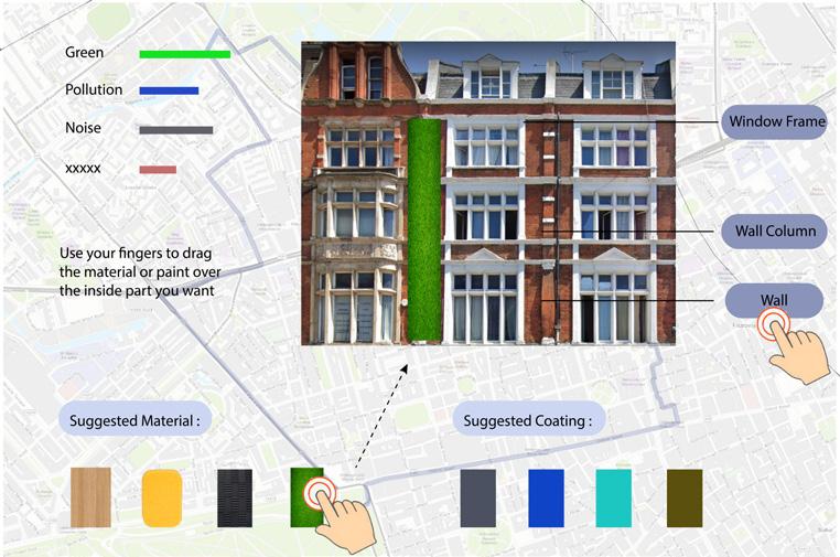
If we are obsessed with improving the aesthetics and sustainability of the façade, the design of the façade will drive up the value of the building and cause the price of the building to skyrocket, in which case the owner or developer will inevitably charge more for the occupants/tenants and the scheme will become a capital tool, which is not our intention.
But in the process of thinking about this may cause gentrification, we found that for wealthy classes and regions, rising house prices and a more gorgeous and glorious atmosphere are acceptable and even pursued, which has to let us go further through this idea. Satire and exposé of neighborhood planning look completely different in the hands of different groups.
In the end, we still wanted to choose a positive entry point to help London’s neighbourhood planning, so we dropped this option.


52 AA Landcape Urbanism 2021 - 2022 5.1 Commercialized Gentrification of Gentrification
Drawing: Jiacheng Sun Guang Yang
Building Facade Initial Idea Sketch | Content: Jiacheng Sun | Edit: Charpter 5 - Game Iteration History & Future Plans AA Landcape Urbanism 2021 - 2022 5.1 Commercialized Gentrification of Gentrification
Case Studies for Commercialised
Help people to design nice building facade FEEDBACK AND RESULT PURPOSE TOOLS
5.2 ITERATIONS


A POSITIVE RESPONSE TO SOCIAL ISSUES
When the study was repeated in May 2021, the vacancy rate had risen by 16%, although some of


9% in January 2021 to 17% in May 2021.

So we started by designing an interactive map

the community to better gather people’s opinions and allows people to see what others have to say more about the community, such as building owners, developers, realtors, etc. After submitting their opinions about the community, we provided an interface for people to enter their needs and sort them, which allowed us to keep a good record of what people wanted and to further process and visualise the data. After people initially enter their postcode, they are shown their location on the interface and we process the data to show the nearest 1-2 simultaneously used spaces that their needs correspond to. After processing the data, we match the different demands for simultaneous space use, and the demands near the simultaneous space use are ranked according to the number of people providing those demands to prioritise the demands.

At the same time, we analyse the data of this community space in the backend of the system and express what we consider to be the problems of this space and the corresponding solutions in a game-like way. If people choose these needs, the character they control is rewarded with an attack, indicating that their need is exactly the solution to the community’s current problem. Along with the visualisation of the data, we matched the number of demands people had, and the more people with the same demand, the stronger the weapon durability of the game character, indicating more demand.
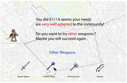


Different numbers of needs correspond to different weapon durability levels.


Once you have completed the attack power and weapon durability of the game character, it is time for the ene-mies. The enemies of people’s demands are undoubtedly the site factors that prevent people from fulfilling their needs, such as the developer’s plans, the history of the building, etc... These are translated into the life points (HP) of the monstersOnce people have chosen their needs and got their weapons, then the battle begins. Every time the charac-ter attacks, the weapon’s durability is reduced and the monster’s life is reduced. When the character’s weapon durability is 0, if the monster has not been defeated, then one’s needs may not be a good solution to these block-ing conditions, indicating that one’s needs are not well adapted to the field. At this point people can try another demand and start fighting again.When the monster is dead and the character’s durability is not yet 0, this indicates that people’s needs far out-weigh the organisational factors, suggesting that people’s needs are very well adapted to the field, which can give landlords and developers a better idea of the opportunities to make money - after all, a lot of demand means a lot of revenue.And when the monster dies and the character’s weapon durability approaches 0, it shows that people’s demand can be adapted to the field, but it is not necessarily the best choice, and people can try again with other weapons to learn the most suitable demand conditions that are really adapted to the field.
After designing the game, we reflected on it and found it to be immature and lacking in many areas.
1 Adults are not always willing to play the game to achieve the effect we want, which might be possible if it were children.
2 People should be decisive in their needs and trying to change them through play is not the best way to do it.
3 Not well thought out for developers and owners of meanwhile use space. It is risky. Once the leased site is irreplaceable in the community, it will change from short-term to long-term use, which is not in the interests of developers and landlords


But we gradually started to focus our research on user needs, and we started to explore an interesting way to document the real needs of users.
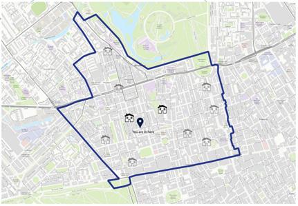
54 Guang Yang AA Landcape Urbanism 2021 - 2022 5.2 “Chasing Demand” Game For Meanwhile Use
Jiacheng Sun | Content: Jiacheng Sun | Edit:
Meanwhile use space @https://www.arup.com/perspectives/meanwhile-use-long-term-benefit Initial Idea Sketch Charpter 5 - Game Iteration History & Future Plans AA Landcape Urbanism 2021 - 2022 5.2 “Chasing Demand” Game For Meanwhile Use
Helping people understand what really works for them, for the community FEEDBACK AND RESULT PURPOSE TOOLS Step 1 Step 2
Subsequently, we tried to start from a more general point of view, without explicitly restricting Local Context and Site-Specific. Attempt to bring into the game the developers who are causing many problems in urban development as a confrontational target. At the same time, the four types of neighborhood planning plans analyzed in Chapter 1 & 2 are also integrated into the game. By recombining the real land use, the urban development projects corresponding to these four types are mixed and dispersed into the four types of land use. Looking forward to getting the “real needs” of players after the game, at the same time through various “intervention” and “protection” skills to let players know more about the tools and regulations of neighborhood planning.


GAME PLAY


This is a strategy game similar to The Plague Company. Developers will wantonly construct within your community. When the development comes, the prices are likely go up, therefore, the happiness index for those who living there will go down. Developers will continue to infect and multiply until all community benefits are fully exploited.


But at the same time, in a certain type of land, they will bring funds proportionate to increase land value, this will add up a small amount of money into your community wallet.
So you have to expect them to randomly come to areas with higher yields and less diffusion effects. The game is a balance between those happiness indexes and money till you die.


Some of the process behind the game will be linked to effective planning items. for instance, obtaining money from development can be associated with Section 106 or Community Infrastructure Levy.

We pixelate and remap the landuse of different Neighborhood Areas into several 15*15 city grids, these forums represent different game difficulties, land type proportions, corresponding initial funds, and residents’ happiness index.


You need to survive from the erosion of developers within the five-year period of a neighborhood plan, by using protective tools to buffer and reduce immediate gentrification from developers. At the same time, the ongoing impact from developers is cleaned up and mitigated with intervention tools.
For example, spend a small amount of community funds to use the “Meanwhile Use” tool to perform activities that meet the community’s expectations, so as to get a small amount of happiness index, and briefly pause the continuous impact of the area for a few rounds to get a chance to breathe.


We found that the game was unbalanced in terms of fairness, that the developer first would greatly reduce the community win rate, that users would need to keep track of predicting future developments while knowing the rules of the space, and that it would also take a lot of mental effort to learn the card skills. This, combined with the number of dynamic variables on the field (spread, turns, blood, money), makes it very difficult and time-consuming to play, taking around an hour to play a game. Finally, the test results tell us that the playability is not very high either.

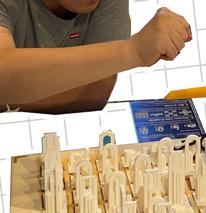


But it built the basic game framework for our follow-up “dummy city”. After two or three small game mechanics adjustments and modifications, our final “Dummy City” was born.


57 56 AA Landcape Urbanism 2021 - 2022 5.3 “Dummy City” 1.0 | Game UI/UX: Jiacheng Sun, Guang Yang
TOOLS 5.3 ITERATIONS INITIAL DUMMY CITY Jiacheng Sun Guang Yang | Drawing: Guang Yang | Content: “Game Mechanism” “Dummy City Version.1.0 Physical Game Board” AA Landcape Urbanism 2021 - 2022 5.3 “Dummy City” 1.0 Charpter 5 - Game Iteration History & Future Plans
SCAN ME! FOR GAME TEST VIDEOS “Digital Version Interface” FEEDBACK AND RESULT
First of all, in our previous presentation and the
game, the developers have always been relatively evil characters in the process of Neighborhood Planning. Because we hope that through this game experience, players and audiences can more deeply understand the social impact and tragedies hidden behind the development, and learn how to deal with them.


However, in real life, there are also great developers who work for the benefit of the community. Therefore, we consider adding third-party players in subsequent game versions that can help the community fight against evil developers, so that players can understand and learn the various abilities and potentials of developers from multiple dimensions.


5.4

FUTURE PLANS
After the final presentation, we can still continue to develop and upgrade our “Dummy City” to further explore the possibilities in terms of game mechanics, social impact, customization, randomness, rationality, entertainment and education. Improve existing rules, further reduce game time, and allow residents of more age groups to participate. At the same time, making physical games more portable can expand more users.
Secondly the next iteration of the game is able to be customised by different local contexts.


For example, in Lee or Roman Road Bow Neighborhood Area, each unique landuse type and spatial form will greatly change the player’s decision-making.


At the same time, the rule Section 1o6 will be significantly different from those in wealthy Neighborhood Areas like Marylebone.

And the initial ‘Effort Points’ for developers and communities will vary accordingly, etc.


In addition, from a long-term perspective, we are also developing an online version of the game, hoping it will be able to function as a wider range of specific “Decision Making” data collection and user analysis for different local contexts.
The last one, in order to further improve user engagement and randomness of immersive gaming experience, as well as alerting the public to the climate crisis and various social issues.


We will randomly project emergencies such as floods, droughts, wars, etc. on the chessboard. The corresponding area will then change the rules of the game, and the game results and player experience will be further complicated and entertaining.


Finally, we will randomly trigger extreme climate and social events in each Game Round. For example, in extreme weather such as storming and floods, the rules of only Green Plots and its surrounding area will not be affected, and the difficulty of developing the remaining areas on the game board will be doubled. We aim to raise public awareness of the climate crisis and various social issues by those different random events in a more immersive engagement experience.


58 AA Landcape Urbanism 2021 - 2022 5.4 The Future Plans Filming: Siqi Sun | Video Editor: Guang Yang, Siqi Sun | Projection Mapping: Guang Yang | Drawing: Guang Yang, Jiacheng Sun | Content: Guang Yang
AA Landcape Urbanism 2021 - 2022 5.4 The Future Plans
5 - Game
History & Future Plans
Charpter
Iteration
Belgravia Mayfair Isle of dog Lee
That’s all of our team’s research on unequal so-called bottom-up Neighborhood Planning as “Dummy” at this stage. In an ideal world, people are truly empowered to build their homes in more democratic and creative ways that will bring a better future to their communities. But by analysing the differences in the political power structure between London and the rest of the UK, and comparing and analyzing horizontal data from existing forums in London, it is clear that the “better future” originally envisioned by neighbourhood planning has not been realized, or not for all. It is still unable to shake off the social shackles of social hierarchy, education level, income between rich and poor, and nd a fulcrum that can lift these heavy shackles, and try to explore feasible solutions that can increase community participation awake the awareness of effort(time, technology and capital costs) and educate the public through the combined use of our board game “Dummy City”
and “Neighborhood Planning Encyclopedia”.
In the final part of this Booklet, we have also listed a few more ideas for Neighborhood Planning. And at the same time, we have produced, edited, and collated the text content of the “Neighborhood Planning Encyclopedia” for non-professionals and people who want to have a deeper understanding of Neighborhood Planning, aiming to help everyone.
CHANGE - ‘NEW NEIGHBOURHOOD PLANNING +’


Central government has been hoarding and centralizing power in the areas of planning and construction for a long time. A range of economic exploitation, racial inequality, gentrification, social cleansing and the climate crisis have affected people’s lives through profit-oriented extractive development in partnership with external developers. The impact of social security cuts, housing market pressures and reduced funding for local government has forced the state to throw more responsibility back on local government, expecting people to solve problems through their own democratic cooperation and participation. On an ideal level, the Localism Act 2011, through Neighborhood Planning, empowers residents to develop the future potential of their own communities from the bottom up and to take ownership of their own needs. On the one hand, it sets a new policy framework for unscrupulous developers through the Neighborhood Plan, and on the other hand, through the Neighborhood Development Order, it empowers the community
However, from another point of view, differences in factors such as education, income, and social background lead to community planning that is not available to all, and a large number of people at the bottom are not yet involved, which may help exacerbate inequality. Studies have shown that the rise in homelessness in the UK after Localism Act 2011 illustrates the disadvantage of localist policymaking to marginalized groups in society.[46] On the other hand, the state has delegated “services” to municipalities and nancial autonomy, that is, responsibility is decentralized, not money for the performance of its duties.[47] In the absence of sufficiently sustainable financial and technical support, existing neighborhood planning organizations have too many responsibilities while volunteering; long bureaucratic interactions with local planning departments make it impossible to get really effective help for Neighborhood Plans; even nancial resources and official support, all the content written in community plans can only be the beautiful fantasies of the people of the region, once returning to the traditional Public Private Partnership development model, External developers can still use their wealth of experience to squeeze benefits from within the community. Therefore, it is necessary to explore the potential tools for autonomous development within community planning, and this essay will discuss a more radical combination of development models, New NP+ formed by Neighborhood Planning, Community Wealth Building and Public
Common Partnership, to create the ideology and local development of true democratic autonomy that follows.
The Community Wealth Building(CWB) model has excellent potential in terms of the scale of development of a local region and the structural and systemic support for the economic aspects of neighborhood planning. Emergencies such as the covid-19 epidemic and climate crisis have, in different ways, exposed the fundamental dysfunction of the UK national and local economy and the failure of the existing economic system to deliver economic, environmental and social justice for the planet, people and places.[48] In recent years power and responsibility for economic development in the UK has been shifting from local authorities to local enterprise partnerships, with speculative development further exacerbating regional gentrification and locally entrenched systemic poverty and deprivation. CWB is an effective tool for changing this situation at the local level and achieving social and economic justice. Rather than pursuing “Growth at all costs,” it seeks to adjust the makeup of the local economy itself so that wealth is widely held, shared, and democratized. The CWB attempts to shift the direction of local economies from “wealth extraction” to “community common wealth building”; from “environmental extraction” to “environmental management”; from “financialized and high-growth sectors” to “real economy and everyday economy”; from “productivity” to “satisfactory employ-
Advice & Ideas Other Than Tools Introduced Above


On the other hand, Public Common Partnership (PCP) helps neighborhood planning opening up new possibilities in terms of how infrastructure and public service projects can be developed. A popular tool that is now used worldwide for infrastructure and public services such as transport, water and sewerage, energy, environmental protection and public health is the Public-Private Partnership (PPP) (Fig.1).[53] However, the controversy surrounding the privatization of community project assets by private developers is also ongoing, and the accumulation of wealth by a few does not change the inequality within communities. At the same time, PPPs require collaboration to work, but the most important goal of PPP projects is often to achieve coordination, coherence and co-production, rather than consensus on decision-making.[35] Collective decision-making is secondary in PPPs, which further exacerbates the conflict between community infrastructure projects developed by large companies and local interests and demands. For example, the Haringey Development Vehicle programme, which has been cancelled, involves £2 billion worth of social assets to be transferred. The proposed redevelopment plan by private developer Lendlease would demolish 1,400 council houses from 7 estates and replace them with luxury developments and so-called ‘affordable’ houses. There is no doubt that once this PPP project is implemented, a new round of social cleansing and gentrification will hurt the people of Haringey.
From a fair and justice perspective, the UK’s economic transformation and local economic green recovery focus around ownership, control, democracy, participation and green transformation.[55] Thus, the Public Common Partnership offers a new possibility. PCP offers an alternative institutional design that frees us from the simple market-state dualism. Instead, they involve shared ownership between local authorities and civilian organizations, as well as shared governance with specific stakeholders in the project.[56] As one of the core elements of the socialist change project, PCP not only affected the direct redistribution of wealth and power, but also had a positive impact on the development of collective autonomy and the decommodification of daily life. By developing distributed forms of governance, people at the bottom can be fundamentally closer to the decisions that concern them. The ability of national governments to shape the social and collective environment is no longer too strong and centralized, and this power is decentralized and distributed outward to more ordinary people. Through this new form, urban dwellers can become collective decision-makers, moving away from simply being coerced by oligarchs and politicians as consumers or voters.[57] In a way, this is very similar to Localism Act 2011 and the ideal of neighborhood planning to empower people.
The first principle is the Joint Enterprise (Fig.2), in which the state agent (e.g. local councils) and the common associations (e.g. mixed cooperatives or community interest companies) are the principal members. They support, collaborate, co-manage and own a community asset with the organizations (e.g. trade unions, environmental agencies, tenant groups and specialist groups) that run the PCP project. At the same time, each shareholder member has only a single vote, regardless of the number of shares they own and the background they come from. The second principle is ‘distributed democratic control of surplus value’, whereby when a PCP project is formally operational, the profits accumulated through earnings are retained by the Joint Enterprise and are under the collective control of the board of directors. It can then go on to develop the next self-expanding circuit of democratic governance based on new community assets, achieving a virtuous circle of communalisation and democratic ownership. (Fig.3) Most importantly, the primary use of any surplus managed by the Joint Enterprise is to capitalise other PCP projects without expectation of financial return. Projects with clear profit potential, such as energy, water, housing and transport infrastructure, are excellent starting points for PCPs, and thus continue to drive new PCP circuits.


Most importantly, the primary use of any surplus managed by the Joint Enterprise is to capitalise other PCP projects without expectation of financial return. Projects with clear profit potential, such as energy, water, housing and transport infrastructure, are excellent starting points for PCPs, and thus continue to drive new PCP circuits.[58]
With the designation of the Neighborhood Forum, it inherently has the ability to become an agent of the state (as a legitimate owner of public assets) and a common association as mentioned above. We can see that the con-


uential institutions and groups. Local organizations such as schools, t of this spending to the local economy is limited.[50] They can have a huge positive impact on the region by commissioning and buying goods and services within the community, through their workforce and employability and
ment”; from “supporting private enterprises” to “supporting democratic economies”, and so on. [49] The key is the ‘anchor’ institution, for running the CWB by identifying and bringing together local influential hospitals, local authorities, clubs, etc. spend millions of pounds each year on goods and services, but the additional benefit through creative use of local facilities and land assets.[51]
From the outset, the ‘anchor’ led approach has provided utility to justice movements. For example, a central aspect of the Cleveland Model in the US is the use of procurement and spending of an anchor institution to provide financial support for the green cooperative movement. A large worker-owned and community-gain enterprise model, worker ts localized for mutual benefit.[52] By creating multiple ownership of the economy, local employee ownership results in decisions being made for the benefit of the local community rather than going ts being reinvested in the community, local employment or distributed as dividends to each ordinary member. CWB is going to influence key sectors such as local planning, capital investment, energy, transport and housing, and within this, planning and capital investment, as common ve core principles of ‘Progressive Procurement of Goods and Services’, ‘Making Financial Power Work for Local Places’ and ‘Fair Employment and Just Labor Markets’. A better solution to one of the most significant problems faced by community forums when undertaking community planning, the lack of sufficient funding for the development and maintenance of the actual projects in the community plan. The progressive procurement of contracts for community planning projects into smaller bids has facilitated the participation of local small and ts within the community. At the same time, by Making Financial Power Work for Local Places ‘, certain neighborhood planning projects with public investment value allow local authorities and competent anchor institutions to establish cooperative investment funds or local banks, for example using regional pension funds to invest in local public services and
cooperatives, supply local institutions, such as hospitals, councils and universities, that are jointly owned and operated by their members to keep profits into the pockets of external shareholders and investors, with profits areas of community planning, allow CWB to play a considerable role in helping Neighborhood Planning to thrive. Through the CWB’s three of five medium-sized engineering enterprises, the third sector, cooperatives and social enterprises, both to minimize construction costs and to keep development profits infrastructure.
cept of public assets and ownership is crucial in running the PCP. Both changes to private and privatization and collective control of community assets and resources can help to mitigate systemic injustices and crises. Community Asset Transfer (CAT) allow for the transfer of ownership of land or assets belonging to government and local authorities to the local community. Among the groups that can apply for a CAT, neighborhood forums are the perfect vehicle for this, as they have the legal right to change the nature of the land via Site Allocation written in Neighborhood Plan, which will maximize the community’s collective desire for transformation. At the same time, the CAT process involves different or overlapping tasks for different community assets, such as property management, surveying, legal, insurance, park and green space management, etc. The unified management and application of the neighborhood forum will greatly ease the organizational costs and participation efforts of the different interest groups within the community. In addition, the range and quality of data recorded and presented in asset registers of land and buildings held by most authorities varies considerably, from green spaces to exhibition halls to skyscrapers. When trying to understand the history of these assets, how they have been used, their use conditions, reasons for special circumstances, constraints, property rights and various information, this information is not readily available and needs to be collected and collated by the neighborhood forum to produce an ARCHIVE for use in each project. Subsequently, once the neighborhood forum has acquired sufficient ownership and management of the community assets, the two main members of the PCP Joint Enterprise’ can be replaced by the neighborhood forum in a more holistic structure, working with the organizations involved in the operation of each individual PCP project to run the PCP more efficiently. At the same time, when some PCP projects are completed, it can become the new ‘anchor’ institution for local employment creation and procurement needs. A community forum with ownership of multiple anchor institutions could become a ‘Core & Mega’ anchor institution not currently mentioned or imagined in CWB model, and thus lead the community into a new future in a more collective form.
Fig.4. “Transformation of Neighborhood Forum”

Thus, we can see that with the help of the PCP and CWB, a more bottom-up form of neighborhood planning, New NP+, has been born. At the same time, the current responsibilities of the neighborhood forum seem to be too fragmented and complex. And we need to orientate its main responsibilities more towards the coordination and management of residents’ participation and collective intentions, as an aid and catalyst for ‘Joint Enterprise’. (Fig.4) The voluntary nature of the Forum members’ work could gradually be transformed into a non-commercial, paid service that would further strengthen the forum’s ability to manage and finance local assets. In addition, the content of the community plan could further detail the content and timeline of its PCP projects and, thanks to the NDO, each identified project following the Plan Referendum could be responded to and implemented quickly.
Finally, we can imagine that by combining CWB, PCP and democratic community participation, capitalizing on the operation of NP+ does not mean that the wealth and wellbeing of people within the community is equated with money and social status. Collective needs and aspirations and wider social responsibility become the ultimate goal of NP+, and capital interests are no longer equated with a better life, thus making a real difference to people’s future.
Guang Yang | Content: Guang Yang | Drawing:
61 6.1 Advice & Ideas Other Than Tools Introduced Above
Guang Yang 60 Other
Research:
AA Landcape Urbanism 2021 - 2022 6.1
Appdendix - Other Ideas for
Neighborhood Planning
Fig.2. Structure of Joint Enterprise, @Common Wealth
Fig.3.Centrifugal Finance Dynamic Development of PCPs, @Common Wealth
Fig.1. Different Levels of Private Sector Engagement in PPP Contracts, @Wikipedia
APPENDIX 6.1.3 IDEA 3. SUMMARY OF SUGGESTIONS FROM OTHER REPORTS


The recommendations are based on key findings about the role and potential of neighborhood planning in areas of London with high levels of deprivation and the particular challenges faced by disadvantaged urban neighborhoods. They also consider the different organizations and government agencies that could make each recommendation[59]:
1. The Mayor should support existing networks of community and voluntary organisations, boroughs and other interested parties in setting up a neighborhood planning network to support and encourage exploratory work. A scoping meeting to discuss steps forward should take place after the Mayoral election.
2. As neighborhood planning places additional demands upon stretched local authority resources, we recommend that the Local Government Association review the role of local councillors in neighborhood planning and set out some guidelines on what role councillors can, as a minimum, be expected to play.
3. Consider developing a community plan led by social policy and projects rather than just planning projects (central gov-

ernment).
4. Introduce milestone ‘wins’ in the project process to reverse the loss of momentum and provide the potential to unlock additional resources. This could include supporting and upgrading projects identifi funds, for example: - Good Growth Fund to support growth and community development (Mayor of London). -Citizen-led engagement scheme grants to promote community-led research (Mayor of London, GLA, central government). -Community
5. Simplify the route of the Forum neighborhood Planning process, for example by making the process of applying for initial funding more straightforward to remove barriers to entry (local authorities)


6. Consider emerging neighborhood Plans and their priorities in the Local Plan and make it clear that integrating neighborhood plans is part of the soundness test for local plans. Local plans should support neighborhood plans by making room for neighborhood plan by making space for additional detail for their area (Local Authorities, Town Planning Inspectorate
7. Reconsider the criteria for additional funding for neighborhood forums and consider tailored packages of support for urban areas with high levels of deprivation, including: - Re-allocation of government funding for neighborhood forums.Supplementary grant funding for areas scoring high on the Index of Multiple Deprivation, as the London Forum currently struggles to access additional grant funding and additional technical support packages for urban areas with high levels of socio-economic deprivation (central government)
8. Clarify the responsibility of local authorities to ‘support’ neighborhood planning, setting out expected roles and responsibilities in a guidance document with statutory weighting. This should include designating a dedicated focal point for neighborhood planning within the planning team and ensuring that if this changes, the neighborhood forum will be informed

(central government, local authorities)


9. Funding and prioritising peer-to-peer learning activities between community forums across London has been very effective but rare, particularly in supporting small workshop-style activities. Feedback from participants in this study suggests that a small workshop is a very useful format (neighborhood Planning London, GLA)
10. Formalise existing knowledge sharing groups through London Councils (local authorities, London Councils) to promote mutual support and peer learning between local authorities and explore how local skills can be linked to neighborhood forums to provide professional accreditation or other benefits for volunteers. The Londoners’ Skills Fund could support local higher education institutions to facilitate these skills exchanges (central government, GLA) | Drawing: Jiacheng Sun, Guang Yang
APPENDIX 6.1.2 IDEA 2. SUGGESTIONS OF COMMUNITY INFRASTRUCTURE LEVY


The main source of public funding currently serving the construction of neighborhood planning is CIL. Basically, except for a few areas, CIL funding in most areas is not sufficient to meet the needs of the actual plan, and the forum will eventually need to seek external Funding for support.

We therefore recommend that the use of CIL be shifted more from the later stages of community planning to the early stages, where the use of professional services to fast-track the community planning process can provide a better foundation for community development and where the entry of upfront funding can effectively engage the community. At the same time, higher levels of funding should be considered for communities with significant growth potential or poor
Appdendix - Other Ideas for Neighborhood Planning

63 AA Landcape Urbanism 2021 - 2022
62
AA Landcape Urbanism 2021 - 2022
Research: Guang Yang, Jiacheng Sun | Content: Jiacheng Sun, Guang Yang
“Suggestions and Responsible Party for Neighborhood Planning”[60] 6.1 Advice & Ideas Other Than Tools Introduced Above
6.1 Advice & Ideas Other Than Tools Introduced Above
“Process of Community Infrastructure Levy”
In this last appendix chapter, we’ve collated and edited what you need to know about each process in your neighborhood and tools that might help. Hopefully, readers will be able to use this chapter to find the information and content they need when faced with neighborhood planning questions as they would with an encyclopedia.
The Magic Roadmap on the left shows the reading structure and interrelationships of the subsequent content.


64 AA Landcape Urbanism 2021 - 2022 6.2 Roadmap for Neighborhood Planning Research: Siqi Sun, Guang Yang | Content: Siqi Sun | Drawing: Siqi Sun Appdendix - Edited Text Content of “Neighborhood Planning Encyclopedia” AA Landcape Urbanism 2021 - 2022 6.2 Roadmap for Neighborhood Planning
6.2 APPENDIX 6.2: NEIGHBORHOOD PLANNING ENCYCLOPEDIA BREAK DOWN “Neighborhood Planning Roadmap” 6.2 6.3 6.2.2 6.2.3 6.3.4 6.3.2 6.3.5 6.3.6 6.3.7 6.3.8 6.3.9 6.3.1 6.3.3
6.3
A RELEVANT BODY
Neighborhood Planning is only led by “a relevant body”:
1. Parish council (will be ward council in London).


2. A body is capable of being designated as a neighbourhood forum.
“NEIGHBORHOOD AREA”
The area where NPing can be implemented.


A “neighbourhood area” means an area within the area of a local planning authority in England which has been designated by the authority as a neighbourhood area; but that power to designate is exercisable only where—
- 2.1 Deciding on the neighbourhood area oundary[62]


• Neighbourhood areas (town or parish councils).


For town or parish councils, there is a presumption that the neighbourhood area will be the same as the parish boundary. However, they may choose a smaller and more focused area, such as a town or local centre. Clear planning reasoning would be required to support this choice. Also, adjacent parish/ town councils may agree to work in partnership to produce a joint neighbourhood plan.
• Neighbourhood areas (neighbourhood forums). Deciding on the neighbourhood area boundary can be quite challenging in unparished areas. The local planning authority should be able to provide maps as a starting point. Careful thought needs to be given to the question of ‘what is the local neighbourhood?’ Neighbourhood areas may be large or small. For example, it could contain a town centre, local shops, housing estate, employment area, park or combination of these things.
2.2


Preparing the documents for application
• a map identifying the proposed neighbourhood area;
• a statement explaining why the area is appropriate to be designated as a neighbourhood area;
• a statement explaining that the body making the area application (the parish or town council or prospective neighbourhood forum) is capable of being a qualifying body.

2.3 Submitting the application to Local Planning Authority


2.4
Engagement (20 weeks)
On receiving the application for a neighbourhood area, the local authority will publicise it, to give an opportunity for local people to make representations. An exception to this is applications submitted by parish councils for designation of the whole of its area as a neighbourhood area. The local planning authority has to designate the neighbourhood area in such circumstances, so there are no publicity requirements.

2.5
Issue a decision
The local authority should issue a decision on whether to designate a neighbourhood area as soon as possible after the consultation period ends. There are time limits on the time in which a local authority must make a decision on the neighbourhood area. From the day after the application is publicised, decisions are required to be made within 13 weeks (or 20 weeks for neighbourhood areas falling within the area of two or more local authorities).
It is a good idea to ask the local authority the date on which it expects to make a decision. The local authority must give clear reasons for its decision and publicise it, once it is made. The local planning authority will designate the neighbourhood area applied for, or designate it in a modified form where there are planning reasons for doing so. The local planning authority is required to publicise a map of neighbourhood areas that it has designated, which can be helpful to groups when they are looking at defining a neighbourhood area themselves.
(a)a relevant body has applied to the authority for an area specifi plication to be designated by the authority as a neighbourhood area, and (b)the authority are determining the application (but see subsection (5)).[61]
specified in the ap-


To apply for approval for a neighbourhood area, the parish or town council or prospective neighbourhood forum will need to submit the details above to the local planning authority.
Siqi Sun, Guang Yang Siqi Sun | Drawing:
| Content: Siqi Sun
6.3
Preparation of Neighborhood Planning
66
AA Landcape Urbanism 2021 - 2022 6.3
Preparation of Neighborhood Planning - Designation of a Neighborhood Area -
6.3.2 -2: GETTING ESTABLISHED A NEIGHBOURHOOD AREA Appdendix - Edited Text Content of “Neighborhood Planning Encyclopedia”
APPENDIX
6.2 6.2.2 6.2.3 3(1)(b) of Schedule 4C of the Town and Country Planning Act 1990 @UK Government
“Neighborhood Planning Roadmap - Initial Stage”
6.3 Preparation of Neighborhood Planning - Designation of a Neighborhood Forum -
APPENDIX 6.3.3 -3:
GETTING ESTABLISHED A NEIGHBOURHOOD FORUM
3.1-1 Meeting the legal requirements
It is established for the express purpose of promoting or improving the social, economic and environmental well-being of an area that consists of or includes the neighbourhood area concerned (whether or not it is also established for the express purpose of promoting the carrying on of trades, professions or other businesses in such an area),
3.1-2. its membership is open to:
• Individuals who live in the neighbourhood area concerned,
• Individuals who work there (whether for businesses carried on there or otherwise), and
• Individuals who are elected members of a county council, district council or London borough council any of whose area falls within the neighbourhood area concerned, 3.1-3. its membership includes a minimum of 21 individuals each of whom—

• Lives in the neighbourhood area concerned,
• Works there (whether for a business carried on there or otherwise), or
• Is an elected member of a county council, district council or London borough council any of whose area falls within the neighbourhood area concerned, 3.1-4. it has a written constitution
It is a good idea to keep the written constitution as concise, clear and simple as possible. As a guide, it should include:
Government APPENDIX 6.3.3 -2: LEGAL STRUCTURE Legal Framwork for Neighborhood Forum, @Neighborhood Planning Roadmap[63]

2.1 Type of legal structure [64]
Unincorporated structure

An unincorporated structure is a group of people coming together for a particular purpose (e.g. developing a neighbourhood plan).
Incorporated structure
An incorporated structure sets up a legally recognised body. Such organisations can hold property, enter into contracts and the liability of their members is limited.

2.2 The different between Incorporated and Unincorporated
... When selecting a structure for your Neighbourhood Forum, it is important to consider whether an incorporated or unincorporated structure best meets your needs. This section gives a summary of the key differences. It has links to additional information where relevant.
2.3 Key considerations in choosing a legal structure
•The aims of your Neighbourhood Forum
•The powers it needs and any risks it will run.
Do you see your Neighbourhood Forum as a time-limited body operating only until your Neighbourhood Plan is adopted? Alternatively, you may see developing a Neighbourhood Plan as the first step in wider community action to improve your neighbourhood. If you have the latter aim then consider setting up an incorporated structure from the start..
• the name of the neighbourhood forum;


• the purpose of the neighbourhood forum (this needs to include ‘promoting or improving the social, economic and environmental well-being of an area that consists of or includes the neighbourhood area concerned’); working arrangements, including sub-groups, partners and their roles; pattern of meetings and details of how decisions will be made; details of governance, including official positions (such as chair, secretary, treasurer);
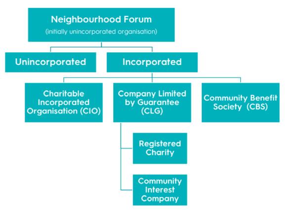
• arrangements for operation and financial management;
• details of how declared interests and potential conflicts of interest will be recorded and managed;
• membership joining procedures for new members;
• duration of the forum (5 years from being approved, as set out in legislation).
3.1-5. such other conditions as may be prescribed.
3.2-1. Preparing the documents for application
• the name of the proposed neighbourhood forum;

• the written constitution for the proposed neighbourhood forum;
• the name of the neighbourhood area to which the forum relates and a map identifying that area; contact details for at least one member of the proposed neighbourhood forum (this will be made public);
• a statement explaining how the proposed neighbourhood forum meets the legal requirements.
3.2-3 Submitting the application to Local Planning Authority
3.2-4 Engagement (20 weeks)
On receiving the application for a neighbourhood forum, the local authority will publicise it, to give an opportunity for local people to make representations.
3.2-5 Issue a decision


The local authority should issue a decision on whether to designate a neighbourhood forum as soon as possible after the consultation period ends. There are time limits on the time in which a local authority must make a decision on the neighbourhood area.
6.4 APPENDIX 6.4.1: OVERVIEW OF “NEIGHBORHOOD PLAN” “Neighborhood Planning Roadmap - Starting Stage”
Appdendix - Edited Text Content of “Neighborhood Planning Encyclopedia”

AA Landcape Urbanism 2021 - 2022
68
| Content:
| Drawing:
leadership, coordination, governance, communication and balanced deciAA Landcape Urbanism 2021 - 2022
“NEIGHBORHOOD
Siqi Sun, Guang Yang
Siqi Sun
Siqi Sun
6.3 Preparation of Neighborhood Planning
- Designation of a Neighborhood Forum -
A neighbourhood plan puts in place planning policy for a neighbourhood area to guide future development. A neighbourhood plan is about the use and development of land and may contain a vision, aims, planning policies, proposals for improving the area or providing new facilities, or allocation of key sites for specific kinds of development. It may deal with a wide range of social, economic and environmental issues (such as housing, employment, design, heritage and transport) or it may focus on one or two issues only.
section
61F of the Town and Country Planning Act 1990 @UK
6.4 Process of Neighbourhood Plan
Process of Neighbourhood Plan
WHAT IS THE EVIDENCE BASE?
Planning practice guidance sets out that proportion-ate, robust evidence should support the choices made and the approach taken. Planning policies need to be based on clear planning rationale and proper under-standing of the place they relate to, if they are to be relevant, realistic and to address local issues effective-ly. The data and
APPENDIX 6.4.3
-1: THE PURPOSE OF PUBLICITY AND ENGAGEMENT
APPENDIX 6.4.3 -2: THE WAY
OF PUBLICITY
Effective community engagement and a robust evidence base are the foundations on which an effective neighbourhood plan will be built. It is important to seek to engage the wider community too, to gain from their knowledge and seek their views.
• The local planning authority should be able to provide support, especially through its own newsletters, publications or by placing notices in libraries and other public buildings.
• Post leaflets through letterboxes
2.1 Range of evidence in different stage
A good approach is to consider the evidence base in stages:
• Early stage: The purpose is to gather information, awareness of people’s views and to identify key issues and themes. These may inform the vision and aims and policies of the plan.
• Notices and/or leaflets could be prepared to place in local public buildings and shops.
• Social media (such as Twitter and Facebook)
• Presence at local events (such as markets and festivals)
things like population, environment, employment, transport links and strategic context.
Mid-stage:As key themes for the neighbourhood plan emerge, more specific
Early stage: At the beginning of the process, general evidence may be compiled to provide an overview of the neighbourhood area. This would include information on c subject-based evidence may be compiled as a basis for formulating specific policies.
2.2 Type of evidence
• Demographic profile of the local population.
• Local employment and industries.
• Land use and planning
• Housing
• Transport.
• Natural environment and special landscape designations.
• Historic environment
• Historic environment
• Urban design
• Community infrastructure
3.1 Review existing evidence:
1. The local plan’s evidence base (Owned by the Local planning authority):
•Assessment of available sites for housing or employment and of the housing market
•Reports or analysis on retail centres and their capacity for growth, on local employment, and on the capacity of the area for other kinds of development
•Census data
•Land viability information
•Records of environmental designations
•Flood risk assessments
•Transport studies etc.
2. Other local documents:
•Parish plans
•Community plans
•Transport plans
•Conservation area appraisals
•Masterplans
•Regeneration strategies
3. Other sources of local evidence
APPENDIX 6.4.2 -2: CONTENT OF EVIDENCE APPENDIX 6.4.2 -3: TWO STEPS TO BUILDING THE EVIDENCE BASE APPENDIX 6.4.2 -4: FINAL FORM OF DOCUMENT INCLUDE EVIDENCES
Strategic Housing Market Assessments (SHMA), Strategic Housing and Employment Land Availability Assessments (SHELAA), Strategic Housing Land Availability Assessments (SHLAA); other local authority plans and strategies, such as economic development strategies; any opinion-based research conducted by the local authority; socio-economic data for district/ward (census and other data); technical reports, such as transport studies and public transport data; conservation area appraisals, buildings-at-risk surveys and landscape character studies; statutory lists (listed buildings, scheduled ancient monuments, registered parks and gardens); details of other environmental protection designations, such as tree preservation orders and sites of special scientific interest and areas of outstanding natural beauty; plans or data from other public bodies or statutory undertakers, such as health or education providers; existing plans for an area, such as a community plan, parish plan or village design statement;
3.2 Identify and develop any further evidence required
There is no existing evidence or because there needs to be a clearer focus on the particular neighbourhood.
Background document
It is not necessary to include the evidence base and outcomes of community engagement in the plan itself. To do so would result in a very thick and unwieldy document. Instead, it is suggested that a background document be created, which lists the sources of evidence, contains any new evidence and summarises the outcomes of the community engagement programme at different stages in the plan process. These should be available through the group’s neighbourhood plan website.
• Mid-stage: Mid-stage community engagement should be designed to provide information needed to develop the detail of the neighbourhood plan.
• Consulting stage: Once a draft plan has been produced, it must be subject to a pre-submission consultation (see later section on Pre-submission consultation).
• Publicity through other local organisations and their networks.
• It is important to create and maintain a neighbourhood plan website
APPENDIX 6.4.3
-3: COMMUNITY AND STAKEHOLDER ENGAGEMENT
3.1
Stakeholders and partners engagement
1. Why partnership working is useful?
Some partners may agree to become part of the neighbourhood forum, where one is proposed, or neighbourhood plan working or steering groups. Some may work closely to support the preparation of the plan. They would be able to provide information and advice, contributing to the evidence base, and may even help in writing parts of the plan. Also, some local groups may have wider memberships or networks, so can help in publicising the plan and in getting local people involved, especially minority and hard-to-engage groups. Thus, they can make life much easier for the parish or town council or neighbourhood forum and contribute significantly to the production of the plan.
2. Local stakeholders and/or partners could include:
• local councillors;
• local shopkeepers and small businesses;
• major employers and business organisations, including chambers of trade or commerce; community groups such as residents’ associations, local civic or amenity societies, local history groups or sports clubs; landowners of key sites or organisations with significant property holdings and developers with site options; local trusts and project groups, such as community development trusts, land trusts or building preservation trusts; not-for-profit organisations representing minority groups (e.g. elderly, disabled, young people, low-in come, LGBT+ groups, faith groups and ethnic groups);
• educational establishments such as schools, colleges and universities;
• community facilitators or activists;
• local institutions such as arts centres, performance venues, architecture or built environment centres;
• health and social care organisations;
• regional or local branches of professional bodies.
3.2 Community engagement
1. The reasons why community engagement is necessary and important
• Statutory requirement.
• Gaining support.
• Better outcomes
• Democratic deficit.
2. The guidance of engagement
•Early stage:
Care should be taken to ask open questions and avoid ‘loading’ the process.
• what is good about the area?
• what is bad about the area?
• what are the neighbourhood’s qualities as
• a place to live and work in?
• what issues affect the area (now or in the future)?
• what change would you like to see?
•Mid-stage:
Mid-stage community engagement should be designed to provide information needed to develop the detail of the neighbourhood plan. For example, discussions could focus on a town centre or local shopping centre, housing needs, or a key public space. For some sites, policies or proposals, different options may be discussed so that people can discuss the advantages and disadvantages of each.
•Consulting stage:
Few people will have the time or inclination to read a detailed document. Therefore, it may be useful to produce a concise summary version. This can set out the aims, main themes and general direction of policy, but in very concise form. It should also set out where the full version of the plan may be exam-ined (on-line and printed copies) and how people may respond.
Build Evidence Base
-
-
70
Siqi
AA Landcape Urbanism 2021 - 2022
Appdendix - Edited Text Content of “Neighborhood Planning Encyclopedia”
Siqi Sun, Guang Yang | Content:
Sun
6.4
- Publicity and Engagement -
and help to identify key issues. These could inform key aims and perhaps a vision for the plan. These in turn may then be translated into policies and, where appropriate, site allocations and Local Green
6.4 Process of Neighbourhood Plan
- Preparing The Plan To Be Made -
6.4 Process of Neighbourhood Plan - Preparing The Plan To Be Made -
be to consider what is the neighbourhood’s USP (unique selling point). This is about identifying those fied.
ing them, and possibly site allocations or Local Green Space designations.
• The basic conditions: have regard to national policy: the National Planning Policy Framework
The Government’s Planning Practice Guidance contribute to the achievement of sustainable development.contribute to the achievement of sustainable development; general conformity with the strategic policies in the development plan for the local area compatible with EU obligations. meet human rights requirements.
• Meet other legal requirements the draft plan is being submitted by a qualifying body as defined by the Localism Act (a designated neighbourhood forum or parish council); what is being proposed is a neighbourhood development plan (planning policy); the proposed plan states the period for which it is to have effect; confirmation that the policies do not relate to ‘excluded development’ (such as minerals extraction of nationally significant infrastructure); confirmation that the proposed plan does not relate to more than one neighbourhood area; confirmation that there are no other neighbourhood plans in place within the neighbourhood area.
APPENDIX 6.4.4 -2:


STRUCTURES OF THE PLAN
The following are suggestions for possible structure and content of the plan:
1. Introduction: Status and purpose of the plan.
2. Vision and aims: The neighbourhood plan can set out the community’s overall vision for the area and should include overall aims for its future development. These can relate to a wide range of planning and regeneration matters – social, economic and environmental. The vision and aims of the plan can then be translated into detailed policies, guidance and proposals later in the plan.
3. Evidence on the area: An overview of the neighbourhood area will provide a useful context for the policies of the neighbourhood plan. This may include the context of the wider area and key evidence (social, economic and environmental data).
4. Summary of community engagement: It is useful to provide a brief overview of the community engagement programme that was undertaken and the key outcomes/issues arising.
5. Planning policies: A neighbourhood plan, once successful at referendum, will form part of the statutory local development plan for the area and will contain policies against which development proposals will be considered. Planning applications will be determined in accordance with the neighbourhood plan’s policies unless material considerations indicate otherwise. Policies should provide a clear indication of how a decision maker should react to a development proposal. It helps if they have supporting text that explains the intention behind the policy.
6. Local green space designations:
Neighbourhood plans may designate Local Green Space. If these are included, a plan showing the boundaries of each Local Green Space will need to be included.
7. Site allocations and/or development envelopes: The neighbourhood plan may allocate key sites for specific kinds of development, such as housing, retail, employment or mixed use. An alternative approach is for the neighbourhood plan to define areas within which development may be located,
8. Supporting guidance:
The policies in the plan could be supplemented if necessary by more detailed guidance (e.g. development briefs for particular sites). This would be helpful in interpreting and applying the policies of the plan.
9. Infrastructure:
Infrastructure proposals relating to the use and development of land could be included in the plan. For example, it could include policies around improving public spaces, highways, pedestrian links or providing new community facilities, providing these were essential to allowing the development of certain sites to go ahead.
10. Matters outside of the scope of the neighbourhood plan: A non-statutory part of the plan could be added, perhaps as an annex, describing proposed actions or projects.
APPENDIX 6.4.5 -1: DEFINITION OF PRE-SUBMISSION CONSULTATION
The 6-week Regulation 14 consultation
Neighbourhood planning regulations (Regulation 14) require the draft neighbourhood plan proposal to be the subject of a pre-submission consultation before it is submitted to the local authority for independent examination. The consultation should last at least 6 weeks. The neighbourhood planning body will need to approve the consultation draft of the plan and that the Regulation 14 consultation takes place.
APPENDIX 6.4.5 -2: OBJECT OF CONSULTATION


•People who live, work or run businesses in the area
•Be sent to the local planning authority
•Certain statutory bodies:
The county council (if applicable);
The Environment Agency; Natural England and Historic England
•Stakeholders:
Neighbouring local, town or parish councils;
Significant landowners; Local nusinesses;
Local community organisations (chambers of Commerce, civic societies, local trusts)
•Anyone on the neighbourhood plan database that has previously been involved


APPENDIX 6.4.5 -3:
CONTENT OF A STATEMENT OF CONSULTATION

APPENDIX 6.4.7: THE INDEPENDENT EXAMINATION
Appointment of independent examiner
The local authority will appoint an appropriately qualified and experienced person to carry out the independent examination of the neighbourhood plan. This person is known as the ‘independent examiner’. The appointment has to be agreed with the neighbourhood planning body.
The scope of the independent examination
The independent examiner will consider whether the proposed neighbourhood plan meets the basic conditions and other requirements set out by law. In addition, they will consider whether the voting area for the referendum should be for the neighbourhood area or a wider area (if the plan is likely to have wider impacts).
The examiner will be considering whether the plan:
• Has regard to national policy;
• Contributes to the achievement of sustainable development;
• Is in general conformity with the adopted strategic local policies for the local area;
• Is compatible with EU obligations;
• Meets human rights requirements.
The examiner’s report
Following the examination, the examiner will issue a report to the local authority and the neighbourhood planning body. If the plan meets the basic conditions, the examiner will recommend that the plan proceed tothe referendum stage. However, they may and usually do, recommend modifications that need to be made to the plan in order to meet the basic conditions, before it can proceed to the referendum.
APPENDIX 6.4.8: REFERENDUM
The details is from the Regulation 14 consultation Details of people and organisations consulted about he proposed neighbourhood plan; etails of how they were consulted; summary of the main issues and concerns raised hrough the consultation process; summary of the main issues and concerns raised hrough the consultation process;
• • The • Details • A • Through • A • Through
APPENDIX 6.4.6: SUBMISSION
Submission of the plan to the local planning authority
The draft neighbourhood plan proposal must be submitted to the local planning authority. The neighbourhood plan submission must include the following:
1. A map or statement, which identifies the area to which the plan relates (a map makes more sense than a statement!); a consultation statement (see later section on the consultation statement);
2. A consultation statement (see later section on the consultation statement);
3. The neighbourhood plan proposal;
4. Summary of community engagement: It is useful to provide a brief overview of the community engagement programme that was undertaken and the key outcomes/issues arising.
5. A statement on how the plan fulfils the basic conditions (see previous sections on the ‘basic conditions’ and later section on the ‘basic conditions’ statement).
6. A statement on how the plan fulfils the basic conditions (see previous sections on the ‘basic conditions’ and later section on the ‘basic conditions’ statement).
| Content:
People on the electoral register will be entitled to vote in the referendum. Where a business area has been designated, there will be two referendums; one for residents and one for non-domestic ratepayers.
If more than 50% of those voting in the referendum vote ‘yes’, then the neighbourhood plan becomes part of the statutory development plan for the area.
Once the plan comes in to force.
1. Use of the plan in development management:
If successful at referendum, a neighbourhood plan comes into force as part of the development plan for the area alongside the local plan. Local planning authorities and planning inspectors considering planning applications or appeals must make their decisions in accordance with the policies of the development plan, unless material considerations.
2. Monitoring: It is important to monitor the neighbourhood plan, once it is made. The town/parish council or neighbourhood forum (or organisation that the forum becomes) should put procedures in place to do this.
3. Updating the plan
Changes in planning legislation and national policy will also need to be monitored, as these may have implications for the policies in the neighbourhood plan. For example, if national policy was changed and then conflicted with policies of the neighbourhood plan, the policies in question would be eroded. It may be necessary to consider remaking the neighbourhood plan, in order to find a resolution.
* Please remember, it is another start when the plan has been made. There are a lot of important tasks waiting for you. :)
72
Yang
Sun | Drawing: Siqi Sun
Siqi Sun, Guang
Siqi
Appdendix - Edited Text Content of “Neighborhood Planning Encyclopedia” AA Landcape Urbanism 2021 - 2022
APPENDIX 6.4.9: PLAN MADE “Neighborhood Planning Roadmap Final Stage”
THE TYPE OF FINANCIAL SUPPORTS

1. Specific Neighborhood Grants (such as the Locality neighbourhood planning support programme): 3. Local Donations; 4. Local Businesses/ Chambers of commerce; 5. Developers and Landowners;
6. Local authorities: Community Asset Transfer (CAT
The Community Infrastructure Levy (the ‘levy’) is a charge which can be levied by local authorities on new development in their area. It is an important tool for local authorities to use to help them deliver the infrastructure needed to support development in their area. The money raised from the CIL can be used to support development by funding infrastructure that the council, local community and neighbourhood want, like new or safer road schemes, park improvements or a new health centre.
A community with a Neighbourhood Plan will receive 25% of any CIL arising from development in their area compared to a community without a Neighbourhood Plan who will receive 15%. There is some discussion on the fairness of this but this is the likeliest outcome.

“ASSETS OF COMMUNITY VALUE”
APPENDIX 6.5.2 -3: “COMMUNITY


RIGHT TO CHALLENGE”
The Community Right to Challenge was designed to achieve three outcomes, all of which were manifestations of the government’s Big Society vision: [70]
Reform public services by increasing the diversity of local service providers, and improving innovation and responsiveness to local community need Reduce the cost of service provision by giving the community the right to challenge the council to deliver a better value service
Empower communities and citizens by giving them the statutory right to challenge local authorities and have their EOIs considered. This liberation of local imagination was intended to revitalise local services to better meet the needs of local communities. ...
In practice, the Community Right to Challenge could only be enforced by two types of organisation:
“Relevant authorities The Act lists the following as relevant authorities: a) A county council; b) A district council; c) A London borough council; or d) Any other person or body carrying out a function of a public nature specified by the Secretary of State in regulations. (Certain fire and rescue authorities are added as relevant authorities in the Regulations)...
“Relevant bodies - The Act lists the following as relevant bodies: a) A voluntary or community body; b) A body of persons or a trust which is established for charitable purposes only; c) A parish council; d) Two or more employees of the relevant authority; or e) Any other person or body specified by the Secretary of State by regulations.”
APPENDIX 6.5.2 -4: “COMPULSORY PURCHASE ORDER”
A compulsory purchase order (CPO) is a legal process that allows acquiring authorities (including public and private bodies) to require those with interest in property, e.g. owners and occupiers, to sell their interests if they obstruct any development or infrastructure project that benefits the ‘greater public good’.[71]
CPO’s are common for public projects like road improvement and rail schemes, airport extensions, urban regeneration projects and utility and infrastructure developments. For a CPO to be successful, the acquiring authority must meet certain criteria, including proof that the purchase is of public interest. CPO’s can be issued by various acquiring authorities, including local government and regional development authorities, utility companies, government agencies and transport companies, e.g. HS2.
Acquiring authority cannot force a private homeowner to sell their land or property. Anybody looking to purchase private land needs to secure a CPO and can only do this after demonstrating why it is required. This is usually (but not always) through a public inquiry process. Sometimes, as in the case of water companies, powers giving access to land are contained in legislation specific to that utility. Additionally, special rules exist for very large schemes such as power stations and transport projects.
APPENDIX 6.5.2 -5: THE PROCESS OF A CPO

A CPO can be lengthy and drawn out. Here we lay out the step-by-step compulsory purchase order procedure[72]:
Step 1: The applicant must undertake a feasibility study of the area and surrounds to determine what extent of the land is required. The land being considered should form part of the feasibility study.
Step 2: The applicant will contact the landowner/occupier to make arrangements to negotiate.
Step 3: Once the initial negotiations are over, a draft CPO may be served should the landowner decline a sale. Landowners should contact the authority for a better understanding of the process and what is expected. You should also keep track of all events and expenses associated with the CPO. The applicant will then have to compile a CPO report in readiness for both landowner negotiations and an inquiry with the appropriate authority.
Step 4: The landowner must provide additional information, including proof of ownership of the land. Any failure to provide requested information or providing false information is illegal. If you have been served with a draft notice, you should seek legal advice immediately.
Step 5: Once all the relevant data has been collected, the authority can work towards an inquiry to uphold the draft orders. The draft CPO should include details like plans for the area, the owner’s particulars, and the details of any third parties. Additionally, a press release announcing the proposed CPO must be published in the local newspaper for at least two weeks and a physical notice must be erected on or near the area of interest.
Step 6: A separate notice will also have to be served to everyone who will potentially be affected by the draft CPO. These notices should also detail how and when objections will be considered and suggest a suitable time for a hearing.
Step 7: After the closing date for any objections has passed, it will be decided if an inquiry is necessary, depending on the legitimacy of the objections. The outcome of the inquiry will determine whether the CPO is accepted, rejected, or needs to be modified. Reasons for the decision should also be given.
It acts as the first stage in identifying and nominating buildings or other assets such as land that have a main use or purpose of furthering the social wellbeing or social interests of the local community, and
Assets of Community Value (ACV) form a part of the Community Right to Bid. could do so into the future.
Once listed as Assets of Community Value with the local authority, the local community will be informed if they are listed for sale within the five year listing period. The community can then enact the Community Right to Bid, which gives them a moratorium period of six months to determine if they can
raise the finance to purchase the asset. [67]
How Assets of Community Value are identified?
A building or other land is an asset of community value if its main use is or has recently been to “further the social wellbeing or social interests of the local community” and it could do so in the future.
Step 8: Once the CPO is successfully accepted, the landowner will be eligible for compensation, which will be calculated according to various factors like the value of the property.
Their PURPOSE – the purpose to which they are being or have been used, rather than the nature of the asset itself – i.e. not in terms of any historical or architectural merit or location or rarity value.
The Act defines assets of community value in terms of: value.
Their LOCATION – local authorities will handle assets of community value nominations within their local area – they are expected to co-operate with the neighbouring authority if the site of an asset of
community value crosses the boundary.

Their OWNERSHIP – all ownership, whether publicly or privately owned.[68]
Note:

Assets of Community Value (ACVs) can only be nominated if they are of interest socially (such as for sport, culture or recreational uses) or increase the wellbeing of the community now and into the future.
profit organisation local authority.
(or has recently furthered) their community’s social Guang Yang, Hantang Li |
A community group (such as a society, parish council, neighbourhood forum, not for profi or a group of at least 21 individuals) that is locally connected to the area can nominate an asset to the Guang Yang
75
74 6.5 Supports for Forums & Community
submitted
The draft neighbourhood plan proposal must be
Appdendix - Edited Text
Planning
AA Landcape Urbanism 2021 - 2022 6.5 Supports for Forums
Content: Hantang Li | Edit:
Content of “Neighborhood
Encyclopedia”
& Community - Financial, Political & Technical Supports -
@Community Asset Transfer
@Relationship between the levy and NPs in England[65]
APPENDIX 6.5.2 -8: “SITE ALLOCATIONS”

4. Where the Council has identified sites at a Local Plan consultation stage to be developed but where the Qualifying Body (Parish/Town Council or designated Neighbourhood Forum) considers that there is a different way of delivering the housing needed (the Thame approach).
Why allocate sites in your neighbourhood plan?[79]
For many places there are four main reasons:
1. Where the Qualifying Body (Parish/Town Councils or designated Neighbourhood Forum) has identified/recognised a need for housing in their area but the local plan is not proposing to allocate sites:
APPENDIX 6.5.2 -9: “LOCAL GREEN SPACE”
APPENDIX 6.5.2 -10: PARTICULAR CIRCUMSTANCES


APPENDIX 6.5.2 -6:


“COMMUNITY ASSETS TRANSFER”
Community Asset Transfer (CAT) is a change in management of land or buildings from public bodies (e.g. local authorities) to community and voluntary sector groups, such as a social enterprise, a Community Interest Company etc. for less than market value to achieve a local social, economic or environmental benefi [73]
Risks with Community Asset Transfers[74]
Community Asset Transfer requests will usually be for long term leases. The grant of a lease of land and property is the grant of a legal estate in the land and property with exclusive possession to the tenant for the duration of the lease. The Council will need to ensure the land and property remains available for the benefit of the community.
The Council will need to consider and as appropriate take measures to mitigate any risks associated with the proposed tenant organisation which include:
• Failure to deliver the project and outcomes;
• Exclude users from the land or cease to operate the facilities on theland;
• Sale of the property to another party;
• Mortgage the property and in the event of default on the mortgage, the • mortgagee could take possession and sell the property to another party;
• The tenant organisation could fail financially and become insolvent and any • mortgagee could take possession and sell the property;
• Application to the Upper Lands Tribunal to remove or vary the community user provisions to some other non-community use in long leases for a term of 40 years or more.
Public Request to Order Disposal Form, @Communities and Local Government[75] Asset Transfer Route Map, @Development Trusts Association Scotland


a) because they are not needed to achieve the overarching housing targets for the District; and/or b) because sites identified are not of a size that they are appropriate to be allocated in the Council’s Local Plan (the test is that the sites to be allocated are those that are needed to deliver the Strategic Vision and Spatial Strategy for the area). This is the case for the St Albans City and District Council area.
The Local Green Space policy was introduced in the National Planning Policy Framework (NPPF) of 2012, after CPRE had campaigned for more powers for local people and protection for green spaces with ‘intrinsic character’. The policy gives communities the chance to apply for a Local Green Space designation affording the same level of protection as Green Belt status. Spaces valued on account of ‘a particular local significance’ are deemed suitable, as long as they are close to where people live and not ‘extensive tracts of land’.
What is the National Planning Policy Framework?
The National Planning Framework (NPPF), published by the Department for Communities and Local Government in March 2012 and most recently updated in July 2021, sets out the government’s planning policies for England.
The land has to be ‘reasonably close to the community it serves’. There is no definition of this in the NPPF and it will be up to individual planning authorities to define. This may vary depending on the size of the community to which the green space relates, the size of the green space or the value placed on it by the community.
benefit.
How does the Community Right to Reclaim Land work?
Where councils hold unused or under used land, anyone can submit a request to the Secretary of State for Communities and Local Government requesting that the council is directed to dispose of the land so that it can brought back into use.[76]
In England, large tracts of previously developed land are vacant or underutilized. Most are owned by public institutions. Since assets are held on behalf of taxpayers, they must be used efficiently. When land is no longer needed, it should be sold, such as for housing or other development, or for use as public or community space.
Community Right to Reclaim Land Order make it easier to put land back into use if the land is owned by local authorities or other public bodies such as the Environment Agency, the BBC or the British Transport Police. A full list of these agencies is provided in Schedule 16 of the Local Government, Planning and Land Act 1980.
Under the community’s right to reclaim land, anyone can make a request to the Minister of Communities and Local Government stating why they believe:
1. The land or property described in the request process is underutilized or vacant;
2. No suitable, consulted and publicly tested plans are in place or likely to be in place within an acceptable time period;
3. The land shall be disposed of by its current owner so that it can be put back into use;
Once a request has been submitted under the Community Reclamation Land Rights, it will be assessed by the Secretary of Community and Local Government, which will include learning from the current owners of any plans of use they may have. If, after this stage, the Secretary of State decides that the land is vacant and underutilized, and the council has no plans to bring it into use, they can issue a notice of disposal requiring the public agency to dispose of the land.[77]
| Content: Hantang Li | Edit: Guang Yang
2. The Council’s Local Plan has set specific housing targets for Neighbourhood areas. This is often based on an understanding of the local needs within an area, that there are potentially enough sites identified within the Neighbourhood area, and that the allocation of sites forms part of the Council’s overall strategy. However, the decision as to which sites should come forward is for the Qualifying Body (Town/Parish Councils or designated

Neighbourhood Forum) so that they can decide which sites work best for their local area.
3. Where the Qualifying Body (Parish/Town Council or designated Neighbourhood Forum) has identified the need for housing but no sites have been identified.

Paragraphs 101 to 103 introduce a Local Green Space designation (LGS) to protect local green areas of special importance to local communities.
This enables communities, in particular circumstances, to identify and protect areas that are of value to them through local and neighbourhood plans.
LGS is designated by the planning authority (borough, district, metropolitan or other unitary authority) and once it is in place, it is subject to the same strong development restrictions as Green Belt, ruling out new development except in special circumstances.
Local people need to lobby the authority to designate LGS, based on a set of special criteria.[80]
The land must not be isolated from the community. Some councils have policies relating to LGS and have introduced a maximum distance between the space and the community. For instance, one has stated it must be within 400 metres, another 600 metres. The land has to be ‘demonstrably special to a local community’.
Evidence must be provided of the land’s value to and use by the local community to show that it holds a particular local significance. The land must fulfil one or more of the following criteria:
(a) Beauty
This relates to the visual attractiveness of the site, and its contribution to landscape, character and or setting of the settlement. The LGS would need to contribute to local identity, character of the area and a sense of place, and make an important contribution to the physical form and layout of the settlement. It may link up with other open spaces and allow views through or beyond the settlement which are valued locally.
(b)
Historic significance
The land should provide a setting for, and allow views of, heritage assets or other locally-valued landmarks. It may be necessary to research historic records from the County Archaeologist or National or Local Records Office.
(c)
Recreational value
It must have local significance for recreation, perhaps through the variety of activities it supports, and be of value to the community.
(d)
Tranquility
Some authorities have an existing tranquility map showing areas that provide an oasis of calm and a space for quiet reflection.
(e)

Richness of wildlife
This might include the value of its habitat, and priority areas may have been identified by the council. It may require some objective evidence, such as a designation, like a wildlife site or Local Nature Reserve.
The land needs to be ‘local in character, not an extensive tract of land’.
The criteria may differ between settlements depending on their physical size and population.
Islington’s Development Plan, @Islington Council
The areas would normally be fairly self-contained with clearly-defined edges.

76
APPENDIX 6.5.2 -7: “COMMUNITY
AA Landcape Urbanism 2021 - 2022
Supports for Forums & Community - Financial,
RIGHT TO RECLAIM LAND”
6.5
Political & Technical Supports -
Forums
Appdendix - Edited Text Content
Planning Encyclopedia” AA Landcape Urbanism 2021 - 2022
Guang Yang, Hantang Li Political & Technical Supports -
of “Neighborhood
6.5 Supports for Forums & Community - Financial,
The Site Allocations document does not list every site. Its focus is on larger sites which will deliver significant amounts of development such as housing or employment space, or other sites where there is a need to support specific objectives, such as community facilities or open space.[78]
What are the ‘particular circumstances’ that qualify a piece of land for Local Green Space Designation protection?[81]
LOCAL GREEN SPACE DESIGNATION
tenancy agreementor lease. The term was introduced by Meanwhile Space CIC during the Depart-
In 2009, the first central government programme on meanwhile use. It describes a process of “indexperimentation. Meanwhile Space’s approach is distinct in its ethos, in that it encourages low-cost


nity care projectsand start-ups.

By investing in local communities and developing
failing perceptionof classifying meanwhile projects as frivolous efforts to place-making and urban regeneration. Core principles of affordability and flexibility coupled with a strong drive for systematic engagement with local networks and agency has led Meanwhile Space to its biggest achievement:
of meanwhile uses within the UK local planning framework. The ‘Open Doors pilot’, a recent government initiative,aims to promote meanwhile uses as amechanism for high street revitalisation.

For the pilot’s implementation, the Ministry of Housing, Communities & Local Government (MHCLG) works in collaboration with Meanwhile Space CIC and The Meanwhile Foundation.This
rates is a pressing issue for town centres andneighbourhoods in the UK, while the impact of austerity leaves local authorities increasingly reliant on local income. Specifically, in the context of the UK high street, the potential for meanwhile uses to contribute to local well-being has been identified since the Portas Review into the future of high streets,. Published in 2011, and earlier in 2009 by DCLG in its report ‘Looking after our town centres.’ Acting in synchwith its time, Meanwhile Space followe grass-roots international movements of ‘temporary urbanism’ which were manifesting in Germany, France, Denmark and elsewhere, and were claiming the right to cheap, small-scaleinterventions in urban space for the improvement of urban life through active citizenship and participation.[83]
79
78
6.5 Supports for Forums & Community - Financial, Political & Technical Supports -
Forums
Content:
| Edit:
Yang Appdendix - Edited Text Content of “Neighborhood Planning Encyclopedia” AA Landcape Urbanism 2021 - 2022
-
Meanwhile Use, @Arup
Guang Yang, Hantang Li |
Hantang Li
Guang
6.5 Supports for Forums & Community
Financial, Political & Technical Supports -
APPENDIX
6.5.2 -12:


“COMMUNITY RIGHT TO BUILD (NDO)”
A Community Right to Build Order is a type of Neighbourhood Development Order which gives community organisations the power to deliver development the local community want without the need to apply for planning permission and forms one of the neighbourhood planning tools introduced in the Localism Act 2011. For example: homes, shops, businesses, affordable housing for rent or sale, community facilities or playgrounds.
A particular advantage of using Community Right to Build is that where the community organisation decides to also undertake the development, then any profit generated by the project must stay within the community.
So buildings constructed by the community organisation can only be disposed of, improved or developed in a way that benefits the community. The community organisation can also ensure certain provisions are put in place so that affordable housing remains affordable in perpetuity.
Community Right to Build Orders are a special type of neighbourhood development order (NDO). Unlike NDOs and Neighbourhood Development Plans (NDPs) however, any local community organisation, not just a parish or town council or a neighbourhood forum, is able to create a Community Right to Build Order.
A Community Right to Build Order can be produced at the same time as a neighbourhood plan, or separately.

To be eligible to develop a Community Right to Build Order in a particular neighbourhood area at least one half of a community organisation’s members must live in that neighbourhood area. The organisation must also exist to further the economic, environmental and social well-being of the area in question, and any profits made as a result of Community Right to Build Orders must be used for the good of that community, not for private gain.
Development brought about by Community Right to Build Orders is likely to be small scale, and will not be able to take place if it would need an Environmental Impact Assessment or would be on a European designated site, for example a Site of Special Scientific Interest.
A Community Right to Build Order may only be prepared by parish and town councils and community organisations that meet certain legal requirements. For example those who live in the area must have a majority of the voting rights. This means it is under the control of people who know and care about the area.[84]
KEY STEPS FOR
LOCAL PLANNING

need to demonstrate that the majority of members of your organisation live in the neighbourhood area.
identifying and tackling cases of unauthorised development, the enforcement
Early consultation and evidence: they need, what’s available?
opportunities for everyone to put forward their views on the project. You will ultimately need to reach a
3.Present your proposals in the form of a Community required documents – to your local planning authorexaminer checks to make sure the proposal is legal and that it meets certain rules and regulations. If it
4.Your local authority will then arrange a local referendum. They will bear the cost. If over 50 per and you will not have to seek a traditional planning permission. No building work can actually start though, until your agreement with the landowner is pelled to agree to your proposals.
5.A successful Community Right to Build Order results in planning permission for development to grant outline or full consent. If it grants outline consent, there would still be reserved matters applications to consider. Other consents, such as building regulations, must be applied for separately.[85]
• Iterative process – community buy-in Grange – good practice Lower Allithwaite
delivery within plan period
Supporting during drafting and

Policy writing can be a big challenge -
• Their capacity and the quality and quantity of any other support they have –but know your limits!
dence of it
• Continuity and maintaining progress
• Ensure the Plan is ready
you!
GUIDANCE
• Streamline the reporting process right through to adoption/making the plan


• Implementation


Submission & the LPA’s consultation

Submission documents – check – return if necessary
• Basic conditions
• Refer back to legislation and checklist
• Ensure consistency with their consultation e.g. who was consulted?
• Similar process as for Local Plan
• NPIERS – line up an examiner as early as possible


• Keep electoral services aware of progress
• It is their Plan – keep them updatDevelopment Plan
81 80 AA Landcape Urbanism 2021 - 2022 6.5 Supports for Forums & Community - Financial, Political & Technical Supports -
| Content: Forums
can apply to your local planning authority. Guidance
Research: Guang Yang, Hantang Li Hantang Li | Drawing: Guang Yang | Edit: Guang Yang Appdendix - Edited Text Content of “Neighborhood Planning Encyclopedia” AA Landcape Urbanism 2021 - 2022 6.5 Supports for Forums & Community - Financial, Political & Technical Supports -
The diagram on the left summarizes the tools mentioned above, rearranged and divided according to “scope of involvement”, “degree of difficulty”, “degree of intervention” and “degree of protection”. When faced with neighborhood planning problems, people can use it to quickly find tools that may work, and then use our encyclopedia to understand the corresponding tools and methods in more detail.
for
Development”
Resource
Supports, @Locality
APPENDIX 6.5.4: TOOLS
“Tools
Community
Useful
for