
BIODIVERSITY CONSERVATION


2
Acknowledgment
This Design Dissertation journey was very challenging, overwhelming and learning. Which would not have been possi ble without the support from many people, who trusted me and helped in the process of research. I would like to take this oppor tunity to extend my gratitude to everyone who helped me along this journey.
I would like to express my deepest gratitude to my mentor Ar. Gayatri Karkhanis-Narkar who guided me and helped me through the research and encouraged me to complete this book. This endeavour would not have been possible without your guid ance. Thank you, ma’am, for your valuable inputs which bought this research to its maximum potential.
I would like to express heartfelt gratitude to my parents, Prakash Parab and Sangita Parab for supporting me and be lieving in me throughout the dissertation journey. I would also thank Ritika Sachan for always encouraging me and never letting me give up. Lastly, many thanks to my friends, fellow batchmates and seniors who have directly or indirectly helped me into com pleting this research.
3
4
ABSTRACT
Biodiversity, environment, and most importantly animal wildlife present in an urban landscape faces significant distur bance caused by uneven urban development of a city. There fore, creating an opportunity to tackle this through study of the threatened biodiversity areas which aims to determine how biodiversity safe architecture interventions and strategies can save the biodiversity in an urban context.
This research is based on the concept of how people who live in urban areas are oblivious to their surrounding biodiversi ty, they don’t know much about of how they are interdependent in this cycle of the urban ecosystem. Public should be aware about how human activities are a major reason behind the deg radation of nature and how it will affect the balance of nature leading to various manmade disasters that cannot be imagined or predicted.
This thesis inspects the ecosystems present in Mumbai and Navi Mumbai, how urbanization is affecting the biodi versity present in these ecosystems. By studying the spread of the metropolitan region, mapping of the vanishing green areas containing rich biodiversity and various ecosystems. discovering the areas which are in an immediate need of attention. Inspect ing these threatened areas and making notes about various issues that could be present. Eventually searching for solutions of these issues.
The expected outcome will be the observation done via this research will help to find the threatened ecosystems in urban context. Then to identify Architectural interventions and green infrastructure strategies that are favourable to biodiversity and that could be used to help in restoring the green areas which were harmed cause of urbanization. And becoming an example of Regenerative architecture in an urban context.
On the basis of this research, conclusions and mitigation majors can be drawn for the specific site which will be finalized by analysing the hotspots present in the developing city like Navi Mumbai, which will help to reduce the impact of future develop ments.
5
CONTENTS
1. Introduction
1.1. Introduction 1.2. Aim 1.3. Objectives 1.4. Scope 1.5. Limitations 1.6. Methodology
2. Literature Review
2.1. Introduction 2.2. Selection Parameters 2.3. Literature Review 2.4. Inference and Conclusion
3. Urbanization and Nature
3.1. Understanding the effects of urbanization on nature 3.2. Navi Mumbai: Developing city
3.3. Urban Biodiversity Conservation
3.4. Biodiversity Hotspots in Mumbai and Navi Mumbai
3.5. Why Biodiversity of Kharghar, Navi Mumbai?
10 12 12 12 12 13 14 14 15 19 20 22 24 30 32
6
4. Site Study
4.1. Site Selection Criteria 4.2. Site Comparison 4.3. Site Options
4.4. Site Analysis
5. Data Collection
5.1. Survey and Observations 5.2. Interviews
6. Kharghar
6.1. Ecosystems of Kharghar
6.2. Local Biodiversity of Kharghar
6.3. Green wildlife corridors
6.4. Present Scenario of hills, grasslands and wetlands of Kharghar
7. Case Studies
7.1. Case Study Parameters 7.2. Case studies 7.3. Inferences
8. Issues and Solutions
8.1. Mapping of Kharghar 8.2. Strategies 8.3. Architectural Interventions
9. Design Program
7
9.1. Architectural Proposal 9.2. User Profile 9.3. Design Program 34 36 37 40 46 49 50 52 54 55 58 59 73 74 80 90 94 95 96
8

CHAPTER ONE:
Background:
Tall skyscrapers emerging from the earth ready to be seen along with the vast transport bridge network woven into the urban fabric enabling the development of the city. As the race upsurge for the built properties the unbuilt remains neglected. Cities are not only homes for human beings but also for various flora & fauna too. Destroying their habitat for con structing gray infrastructure leads to a diminu tion in the number of endangered species. The intent of this research is to point out how the rapid urbanization is disturbing the local ecological and natural balance. To spread awareness about above issue through various activities and architecture. Studying the green corridors in urban areas and the obstacles which are formed cause of the uneven devel opment of built properties and figuring out the appropriate architectural interventions for it. These will lead local people to take an initia tive to learn and grow the urban biodiversity. In order to connect better to ourselves, others and the environment, we should improve this connection between architecture and nature.
10 Chapter One : Introduction
01
INTRODUCTION
1.1. Introduction:
Navi Mumbai’s diverse flora & fauna face threat from rapid urbanisation, while some managed to survive in spite of the urban landscape closing in. Some lesser-known green areas have already been swallowed up by urbanisa tion while the impact on more popular habitats like Khar ghar hills and wetlands are visible but yet to be determined through sufficient studies.

Biodiversity zones that make Navi Mumbai liveable for its citizens will vanish, pushing the city to even bigger strife that can’t even be imagined and predicted currently. Despite local communities and the scientific communities emphasizing the importance of building climate resilience promptly, the local biodiversity has been left out of the priority list of the local government. Here regenerative architecture comes into picture of future building develop ment.
Regenerative architecture is a way of engaging natu ral biosphere as the medium for building, and generating sustainable surrounding spaces.
Various local organizations and groups at Kharghar, Navi Mumbai have started to come together to save these habitats of existing and migratory fauna at Kharghar region. They conduct small campaign on social media as well as on field in the hope of government will support these actions and conduct legal action against activities like burning of grasslands, filling up the wet lands, quarry ing of hill, illegal cutting of trees etc.
11 Samvardhana
Figure 01 : Butterfly
1.2. Aim:
To study the urban interventions and strategies towards conserving Urban biodiver sity and spread awareness to make it as a part of green infrastructure that the city needs, forming an amalgamation of People-Activity-Architecture amidst the chaos of an urban area.
1.3. Objectives:
• To Understand the effects of Urbanization on nature in a developing city like Navi Mum bai.
• To understand the existing scenario of Biodiversity Hotspots and the problems which are affecting the biodiversity cycle.
• To plan out the strategies/ mitigation measures to improve the green infrastructure to control storm water runoff and provide alternate sites of refuge for all the fauna who lost their habitat because of the urbanization.
• How to interest and engage local community into learning these mitigation methods on a smaller level to take small steps towards greening their neighborhood locality.
1.4. Scope :
The scope of the research will be limited to the existing biodiversity of Navi Mumbai. Examining these hills and wetlands and finding strategies to improve the conditions of green open spaces in the pockets of the city by creating a refuge for the fauna who has lost its habitats cause of the deforestation. correspondingly how to make individuals conscious about these neglected spaces and their effect on their surrounding ecology, and climate.
1.5. Limitations :
Due to the time constrain the research is intended to be focused on the areas of Navi Mumbai where the Stone quarrying and deforestation is destroying a green hill along with the upcoming Navi Mumbai airport’s ecological impact and how to improve their lifestyle and provide refuge for present flora & fauna.
12 Chapter One : Introduction
1.6. Methodology:
Figure 02 : Methodology Flow Chart

13 Samvardhana
CHAPTER TWO:
LITERATURE REVIEW
2.1 Introduction:
The literature review is carried out by studying various articles, research papers, on line information, books, ted talks. the parameters of this literature reviews are inspecting the impacts which urbanization has over Biodiversity of Mumbai & Navi Mumbai region. to analyze the various characteristics of the issues faced by biodiversity and what could happen if the community takes steps towards conservation.

14 Chapter Two : Literature Review
02
Figure
03 : Literature Review Parameters
Title: Negative Impacts of Urbanization Category: Book
Author: Thomas Elmqvist, Wayne C. Zipperer and Burak Gii.neralp Date: 22 December 2015
1) The main purpose of this article is to display habitat loss & fragmentation are the most obvious detrimental effects of urbanisation on biodiversity.
2) The main issue the author addresses is how urbanisation affects environmental services and biodiversity both directly and indirectly.
3) The most crucial information in this article is that the expansion of urban areas has changed the landcover, which is the most visible direct effect of urbanisation on biodiver sity.

4) The most important idea in this article is that, according to recent projections, the quantity of urban land adjacent to protected areas is predicted to rise globally by an aver age of more than three times between 2000 and 2030.
5) The fundamental premise underpinning the author’s argument is that many biodiversity hotspots threatened by urbanisation are found in developing nations, which are predicted to experience the greatest population growth, and may therefore have less financial sup port for land protection than cities in developed nations.
6) If we take this line of reasoning seriously, there is a need for urbanization strategies that consider biodiversity conservation especially in developing cities.
7) The main point of view presented in this article is A better understanding is required of the supply, needs and management of urban ecosystem services.
Table 01 : Negative Impacts of Urbanization
15
Samvardhana
Title: The Vanishing Biodiversity zones of Navi Mumbai Category: Interview
Author: Ashwani Sharma
Date: October 1, 2021.
1) This article’s major goal is to highlight the gradual environmental degradation occur ring in Navi Mumbai in the context of the city’s growing urbanisation and how it has driven Kharghar residents to battle for the biodiversity that supports and surrounds Navi Mumbai.
2) The main issue raised by the author is how to raise public awareness in order to encour age greater participation in the documentation and preservation of the biodiversity found in the marshes and hills of Kharghar.
3)The following statement is the article’s most crucial detail: Few members of these groups are involved in the environment and wetland committees at the district and municipal lev els that were formally established by associations or by the government authorities. They also work closely with organisations like Maharashtra Forest, BNHS, and other groups and departments that have a similar mission in order to improve the outcome for preserving the biodiversity that the city of Kharghar has been endowed with.
4) The article’s key inferences/conclusions are that since Kharghar’s citizens have brought up this issue with government officials regularly, there is a chance that something con cretely constructive may happen soon.
5) The main idea in this essay is that raising societal awareness of the effects of mangrove and hillside degradation will enable people to protect these areas from future man-made disasters.
6) The fundamental premise on which the author bases his or her conclusions is that there will be long-term effects such as pollution and changes in the flow of water bodies and streams discharge system, which will be disrupted and result in floods.
7) If we truly consider this line of thinking, it follows that biodiversity will begin to flour ish thanks to rising public support for preserving Kharghar Hills and Wetlands.
8)If we don’t consider the implications of this line of thinking, the pollution levels in these areas will increase as a result of hill quarrying, degradation of the forests and wetlands, flooding from the water, and habitat destruction of the current biodiversity in the wetlands and hills, which will disrupt the regional ecology cycle.
8) The primary argument put forth in this article are why it is crucial to get the residents’ voices heard so that the government authorities will take these issues seriously and take appropriate legal action if necessary. to be successful in preventing the builder and munic ipal authorities from acting erratically and finishing what is left of Navi Mumbai’s wetlands and hills.
16 Chapter Two : Literature Review
Title: Mitigation measures
Category: Article
Author: Nareshchandra Singh
Date: April 6, 2021
to point out the negative impact of Navi Mumbai Airport on Nature. the ecology is getting affected cause of clearing out of the existing nature. The airport is coming on top of the Panvel creek, right on where the creek meets the sea. BNHS has observed that the area was major habitat for a large number of migratory birds. The whole area of the airport lies in the path called Central Asian Flyway which is an important corridor for these migratory birds. Altering this natural Flyway is disastrous. This leads to a need for conserving and re storing an alternate refuge site for all the fauna which are getting displaced by the Airport. One of which alternate site is Kharghar wetlands & Hills.

Table 03 : Mitigation Measures

17 Samvardhana
Table 02 : The Vanishing Biodiversity areas in Navi Mumbai
Title: The diverse species existing in Kharghar Category: Video

Author: Tarang Sarin
Date: Oct 26, 2020
The main purpose of this video is for the people living in urban areas biodiversity is oblivious they don’t know much about it the video addresses the need of conservation of biodiversity present in Kharghar and the threats faced by various species. Biodiversity is everywhere around and it’s unappreciated and often ignored by society.
The important information the speaker said in this video is there are 165 species of birds, 39 species of butterflies, 36 species of wild flowers, many reptiles like snakes, lizards, mongoose, etc. were documented on Kharghar hills and wetlands. The present grasslands near Kharghar are spread about 3 km sq. and are prone to dumping of the debris collected from construction sites, burning of these grasslands are leading to habitat destruction of 50 species of birds.
The main inferences/conclusions in this video are the tidal wetlands are main source of food for the existing birds if the continuation of filling wetlands by the debris generated by quarries ecosystem will get affected.
The key concept that we need to learn in this video is Conservation of each habitat is im portant cause the lifestyle of fauna is interconnected with each habitat.
Table 04 : The diverse species existing in Kharghar
18 Chapter Two : Literature Review
2.4. Conclusion:
After reading various articles, books and watching videos it can be concluded that there is an immediate need for our community to learn about conserving Urban Biodiver sity. The urbanization is so at peak that it is eating up the green areas which are important to the cycle of interdependent ecosystems. While researching It was observed that there are many articles about concerned citizens in Navi Mumbai who are trying to get commu nity’s and government’s attention toward the degradation of hills and wetlands.
The Kharghar hills and wetlands are rich in biodiversity various species of flora and fauna are present to research and study. thus, it would be an ideal site for a research and awareness centre, where people can learn about the biodiversity with the help of their surroundings. This research will be focusing on these aspects of urban city and the van ishment of biodiversity hotspots and how to mitigate these impacts through a learning program and research facilities.
19 Samvardhana
CHAPTER THREE:
URBANIZATION AND NATURE
3.1 Understanding the effects of urbanization on nature:
Mumbai -India’s financial capital- Home to over 20 million people, where high rise towers are spreading over slums and old forests stand at odds with this expanding concrete jungle. The remaining green spaces are being devoured by the city’s expanding develop ment and rising infrastructural requirements, resulting in the loss of animal habitats. With the forthcoming threat of climate change there are predictions that by next 50 years the southern part of the Mumbai city will be under water.
Figure 04 : Impacts of Urbanization on Nature

20 Chapter Three :
and Nature
Urbanization
03
Urbanization effects nature in many ways Starting with the sprawl, the rapid expan sion of the geographic extents of the city. The unplanned development leads to concen trated grey infrastructure replacing the natural land cover which absorbs and retains heat. Creating an Urban Heat Island effect. This increases the energy consumption and cost, pollution levels, etc.
Unsustainable development of city had led the decrease of green areas. Mumbai has lost around 42.5% of its green cover in the last three decades alone. The Local commu nities emphasizing on the importance of building climate resilience structures, the local biodiversity has been left out of their priority list.
• Map of the geographic extend of the Green area network and typology in the MMR region.
Figure 05 : Green Area Network

21 Samvardhana
Navi Mumbai: Developing city
Mumbai is one of the most densely populated cities in India, it is also one of top con tributing economic engine of India. that attracts migrants from all over India. That is the base cause of the development. As Mumbai’s space is limited for any expansion the chal lenge appears on the infrastructure of city. There struck the idea of Twin City.
In 1964 Shirish Patel, Charles Correa, and Pravin Mehta came up with the idea of the development into eastern mainland instead of the perpetuating growth in the north direc tion. They came up with a polycentric nodal pattern of development. Each node contains residential, commercial, infrastructure and recreational areas, and having a range of some income groups. Holding ponds were created in these nodes to control excess runoff. Three linear spines were arranged around the CBD (Central Business District). and it became world’s largest planned city.
Figure 06 : Development of Navi Mumbai

22 Chapter
Three : Urbanization and Nature 3.2
Figure 07 : Navi Mumbai green Area
Developing city like Navi Mumbai would be an appropriate urban space to study the growth of urban infrastructure and how it affects the local flora and fauna. After studying the above map, it can be seen that the wetlands have been decreased in the past few years and mostly near the end of Panvel creek where upcoming Navi Mumbai Airport project is happening. Referring to the below map of the travel route of migratory birds, these birds travel via this path every year and the airport is an obstacle in between this route they are in an immediate need for a refuge habitat.

Figure 08 : Migratory Route

23 Samvardhana
3.3. Urban Biodiversity Conservation:
Biodiversity- all the living plants, animals and organisms are essential for our existence. Yet when we think about biodi versity, we picture rural landscapes but a city never comes to our mind. When in fact urban areas are home to a countless ecosystem chains having rich biodiversity. We are embedded in the nature and yet we know so little about it.
The majority of cities worldwide are too busy to confront the harm that urbanisation poses to the natural environment. Today 55% of worlds population live in the city and its going to expand at unprecedented rates, so does the pressure that it puts on the natural resources and ecosystems. Leading to reclama tion of land, deforestation, etc.
Conserving urban biodiversity is important factor, in addition to ensure people’s overall well-being. A variety of eco systems across the city can be preserved, developed, improved, and connected to existing biological corridors to achieve this.
Figure 09 : Biodiversity Loss

24 Chapter Three :
and Nature
Urbanization
3.3.1. Urban Biodiversity Loss:
According to CSE’s Statistics India has lost 90% of area which was under biodiversity hotspots. 25 species have gone extinct in these hotspots. Mumbai being the most devel oped metropolis leading to high demand for land is eating up the green areas of the city. Which directly effects the biodiversity.
Biodiversity loss led by destructing their habitat and fragmenting of any ecosystem’s plants, soil or resources, land use and sea use change caused by uneven and unplanned development, mining, pollution, change in climate, species overexploitation etc.
3.3.2. The Need for Urban Biodiversity:
Variety of species living in an urban context is called as urban biodiversity. The amount of biodiversity present in an area depicts the well-being of that area’s ecosystem. The natural resources and biodiversity are wholly dependent on by the cities for their re sources and services. Without it, the health and operations of the city will suffer.
The biodiversity protects the health of natural ecosystems, improves air quality, pro tects from natural calamities like landslides, floods, erosion of soil etc, reduce the urban heat island effect, Pollination of plants, human wellbeing, medicines, climate control, and many more.

25 Samvardhana
Figure 10 : Biodiversity Services
Figure 11 : Types of Biodiversity

3.3.3. Types:
1.Ecological Diversity: it is all the different communi ties of species, habitats, and ecological processes, also variations which are within their individual ecosys tems.
2.Species Diversity: it is the different between the pop ulation of species as well as the difference types of the species in a given area.
3.Genetic Diversity: it is the genetic variety present within a species.
3.3.4. Importance of biodiversity:
Humans are directly or indirectly dependent on biodiversity for sustenance to a significant extent. However, growing population and developing activities have directed to huge scale diminution of the natural resources.
1.Narrowly utilitarian: Refers to justifications for biodiversity preservation based on the fact that nature provides innumerable direct economic benefits to humanity.
2.Broadly utilitarian: Arguments in favour of biodiversity’s significant importance in the ecological services that nature offers are largely utilitarian.
3.Ethical: Justifications for our obligations to the natural world with which we share this globe.
26 Chapter Three : Urbanization and Nature
Figure 12 : Biodiversity types and conservation approaches

3.3.5. Conservation of Biodiversity:
Conservation of biodiversity means protection, preservation, and restoration of nat ural resources like forests and water bodies and wildlife. Through which the habitats and many species of flora which are threatened by the human activities can be safeguarded. There is an urgent need for conserve this biotic wealth as well as to regenerate the degrad ed ecosystems.
1. In-Situ Conservation:
It is the preservation of genetic resources in wild populations of a particular plant or ani mal species. Through this procedure, endangered plant and animal species are safeguarded in their native environments, either by safeguarding the environment or by safeguarding the animal from predators.
2. Ex-Situ Conservation:
It involves protecting biological diversity components outside of their normal settings. In this process, methods to reciprocate any species’ genetic resources include botanical gar dens, zoos, conservation gene strands and seeds, pollen seeds, tissue culture, etc.
27 Samvardhana
Figure 13 : Biodiversity Conservation

3.3.6. Human-Wildlife Conflict:
When humans and wildlife interact negatively, such as when there is a loss of prop erty, livelihood, or even life, this is referred to as a human-wildlife conflict. Human-an imal conflicts are increasing as a result of excessive urbanization and increasing human encroachment on wildlife habitats. The importance of conserving biodiversity in urban environments cannot be overstated. The legal ramifications of killing wild animals are also becoming more well known. Therefore, it is imperative to regulate human-wildlife conflict in metropolitan areas.
3.3.7. How wildlife is impacted by human activity:
The first global, comprehensive study on wildlife rehabilitation reveals that human activity is one of many variables that lowers the survival rates of injured or dislocated wildlife. The University of Sydney researchers found that incidents like car accidents and domestic animal attacks account for over half of the documented causes of wildlife mor tality and injury, either prior to rescue or after release. They also found that the odds of both mammals and birds surviving every stage of rehabilitation are equal.
Dr. Holly Cope, co-author and dean of the Sydney School of Veterinary Science, asserts that as urbanisation and natural disasters worsen and extreme weather events become more frequent, there will be a rise in the number of animals in need of rescue and rehabil itation. Wildlife staff need to be aware of research findings to improve animal care. On the other side, if proper records are kept, they can help researchers in the future.
28 Chapter Three : Urbanization and Nature
3.3.8. Urban Habitat for wildlife:
Cities are home to numerous wild species. Some of these are present in such num bers that they become part of our everyday lives. But what about the rest, where and why are they disappearing. The major reason behind it is unavailability of food and habitat. All the fauna needs four essential things to survive: food, water, shelter and space. The spatial arrangement of these things needs to be in an order and within a certain distance from each other so that the animals or birds can access them on a daily basis safely.
For conservationists, protecting biodiversity has become much less about securing new protected areas in undamaged habitat and more about making room for wildlife on the edges of this spreading urban built areas. There is no other area left for animals and birds to reside, therefore conservation now frequently involves altering human landscapes to serve as wildlife habitat and also to continue to operate for humans for their houses, factories, highways, etc. Finding solutions for wildlife to coexist in some capacity with urban environments has become critically important in recent years.

29 Samvardhana
Figure 14 : Various types of Species in Mumbai
3.4. Biodiversity Hotspots in Mumbai and Navi Mumbai:
Mumbai is home to thousands of migratory birds and they play major role in the ecology cycle. Bombay Natural History Society (BNHS) has taken up the project to work along the NGO’s and groups who are focused on saving environment, helping them to protect whatever green spaces are left of. Biodiversity hotspots, which are regions with high biodiversity and extinction risk, make up less than 3% of the Earth’s surface. To be classified as a biodiversity hotspot, a region must have lost at least 70% of its original natu ral vegetation, usually as a result of human activity.
Recently a new map was made of biodiversity of Mumbai by cartoonist Rohan Chakravarty which reflects the various species present in the urban city Mumbai. He has presented the map in various colours and among that you can find species from flamingos as well as smallest insects present in the small pockets of the city. He has even marked the important urban green spaces which are needed to be conserved. He also included the Warli and Koli communities. The main motive behind creating this map was to make ever Mumbaikar pause and think about how they share their everyday lives with this incredibly diverse flora & fauna.
Figure 15 : Biodiversity Hotspots in Mumbai

30 Chapter Three
: Urbanization and Nature

31
Samvardhana
Figure 16 : Biodiversity Map of Mumbai
The most significant component of Mumbai’s biodiversity are the mangroves. They control thousands of acres along Mumbai’s seashore. They serve as a natural barrier be tween natural disasters like flooding and others. Since many wetlands have been reclaimed and developed on, mangrove protection has decreased and the risk of coastal natural disasters has increased.
Aarey neighbourhood and Sanjay Gandhi National Park are two of Mumbai’s most well-known biodiversity hotspots. The Aarey colony spans 1300 hectares of forested ter rain. Sanjay Gandhi National Park (SGNP), which spans 87 square kilometres, is also close by. protected area also referred to as Mumbai’s “lungs.”
3.5. Why Biodiversity of Kharghar, Navi Mumbai?:
Kharghar, located in Navi Mumbai is surrounded by multiple ecosystems. These ecosystems have become important cause of the affects surrounding industrial areas are increasing. Cause of the reclamation of land the wetlands seem to be disappearing. So, the load of all the migratory fauna is coming onto the ecosystems of Kharghar. Which as per the news articles are endangered. upcoming project like the Navi Mumbai airport is coming right in on top of wetlands and will be disturbing the flyway of migratory birds. Because of these the concentration of various fauna has been increased in these hills and wetlands.
Having rich biodiversity, it would be an ideal place to learn and experience the biodiversity. People would get to interact with nature and that way our community will help into restoring the surrounding green spaces which are subjected to various issues like burning of hills, deforestation, debris dumping etc.
32 Chapter Three : Urbanization and Nature

Figure 17 : Article Collage
CHAPTER FOUR:
SITE STUDY
4.1. Site Selection Criteria:
Site selection is based on the current green open spaces which are rich in biodiversi ty in the Mumbai city and identifying these hotspots which are in a need for conservation. locations which are prone to various man-made creations which are a threat to the ecosys tem. A site which grounds various potentials that can be displayed through various archi tectural interventions to spread awareness via engaging into interactive activities.
Table 05 : Site Selection Parameters

34 Chapter Four : Site Study
04
Figure 18 : Site Option Matrix
Urban areas like Mumbai and Navi Mumbai are picked due to city growth and to research the effects it has on biodiversity. Site possibilities were chosen based on these characteristics. Seven biodiversity hotspots were chosen after extensive research to com pare the dangers these regions face to their current ecosystems. According to the afore mentioned data, urbanization poses a number of risks to Kharghar’s ecosystems, which are diverse. Thus, the study is concentrated on Navi Mumbai’s Kharghar area.

35 Samvardhana

36 Chapter Four : Site Study 4.2. Site Comparison :
19 : Site Demarcation on base map Site Selection ParametersCriteria Site Option 1 Site Option 2 Site Option 3 Location Kharghar WaterfallsArjun Kada WaterfallsPandav Kada Waterfalls Area 30,000 sq.m. 25,000 sq.m 35,000 sq.m. Urban developments High Medium Low Building Typology Institutional Residential Residential Land Use Science park Open Green Space Recreational Threats High Low Medium Distance from Kharghar Station 900 M 2 KM 4.5 KM Local Community Yes No Yes Tourist Attraction Yes No Yes Water Body present present present Biodiversity low Medium High Scope of Restoration/Rejuvenation High Medium Low Soil Type Clay + Alluvial Clay + Alluvial Clay + Alluvial water body type Lake, waterfalls Waterfall Waterfall Demographics Connectivity Biotic and Abiotic Factors Table 06 : Site Comparison Matrix
Figure
4.3. Site Options :
4.3.1.Kharghar Waterfalls:
Figure 20 : Site one
SWOT Analysis:
o Strength:
• Kharghar Station and Highway are at walking distance from site.
• High Biodiversity area.
• Adjacent to Proposed science park and Bharti Vidyapeeth college.
• Site is near Kharghar waterfalls.
o Weakness:
• Traffic Noise caused by the vehicles from Highway.
• Near high density urban Area.
o Opportunity:
• The program can be a part of the science park.
• Kharghar hills road can be connected to the site.

o Threats:
• Future expansions on the hill behind.
37 Samvardhana
4.3.2.Arjun Kada Waterfalls:
SWOT Analysis:
o Strength:
• Site is surrounded by green open area.

• High Biodiversity area.
• Site is near Arjun Kada waterfalls.
o Weakness:
• Site is hidden from the main highway.
• Only one connecting road.
o Opportunity:
• Nearby Herbal Garden can be a part of program.
• the vally area can be used for recreation.
o Threats:
• water from the Hill slope is directed towards site.
38 Chapter Four :
Study
Site
Figure 21 : Site two
4.3.3.Pandav Kada Waterfalls:
SWOT Analysis:
o Strength:
• site is at the starting of the central park green corridor.

• High Biodiversity area.
• Site is near Pandav kada waterfalls and the trail which goes up on the hill.
o Weakness:
• various upcoming residential projects nearby.
• disturbance from the stone quarry.
o Opportunity:
• strategies can be applied cause of densely polluted area.
• can be connected to the central park.
o Threats:
• expansion of the stone quarry can disturb the hill.
39 Samvardhana
Figure 22 : Site three
Site Analysis :
Figure 23 : Site Plan
Location: Kharghar, Navi Mumbai. Co-ordinates: 19°01’47”N 73°03’18”E Altitude: 8 m above sea level. Annual Rainfall: 4000 mm Temperature: 39°C in the summer and 14°C in the winter.

40 Chapter Four :
Study
Site
4.4.
Site Surroundings:

• Site has two secondary street access one from Bharti Vidyap eeth college and another from the cricket ground.
• Both streets are further di vided by a nahlla which starts from the lake and travels fur ther toward Taloja creek.
• Southern side of the site there are two cricket grounds and Bharti Vidyapeeth college.
• Squatter area is located adja cent to the cricket ground.
41 Samvardhana
Figure
24 : Site Analysis
DP Plan of site :
• The site comes under proposed science park which is educational land use zone.

• The site is near Kharghar hill road which is the only road that goes uphill.
• The site is an open field with brown grassland thus there is a scope of rejuvenation.
• An abundant lake is present on site which collects the water flowing from the valley between the hill.
• Electric towers are present on the hill slope behind the site and since the wires are pass ing above the ground leaving distance of approx. 12-15 m below building cannot be con structed in that space.
42 Chapter Four :
Study
Site
4.4.1.
Figure 25 : DP Plan
4.4.2. Site Views :
Figure 26 : Site Views

43
Samvardhana
4.4.3. Site Vegetation and Hydrology:

The site is covered with vari ous types of shrubs and tall grasses. There are no existing trees present on site. There is a small lake present on site which a lot of lotus plants (Nelumbo nucifera) floats on the lake. A water channel runs along side of the road emerging from the lake itself and forming a nahlla which then meets the second lake few meters ahead. All the water flowing from top of the hill flows through the valley and meets the lake. The groundwater table is high in the path of the valley.

44 Chapter
Four : Site Study
Figure 27 : Site Vegetation
Figure 28 : Natural water Runoff on Site
45 Samvardhana 4.4.4. Site Dimensions and Sections : 200.00
14
B
SECTION AA' SECTION BB'
Site Dimensions & Sections
180.00 110.00 70.00 73.94 105.00 AREA: 30,000 sq. m. LAKE 9 10 11 12 13
10 11 12 9 A A'
B'
Figure 29 :
Figure 30 : Survey Pie Charts 1

46 Chapter Five : Data Collection
CHAPTER FIVE: 5.1. Survey and Observation: 05 DATA COLLECTION
Figure 31 : Survey Pie Charts 2

47 Samvardhana
Observations:
The survey was answered by people with different age groups and professions. Total 50 responses were collected. It was observed that half of the people lived in the Mumbai suburban area and more than 60% of them go for walks in their nearby parks. 65% of then are having 1-3 parks in their vicinity and 85% of them are wanting to have more green open areas around their neighbourhood.
Only few 35% of them knew about the Costal and Ma rine Biodiversity centre which is located in Airoli. Total 97% of them answered yes to learning more about urban biodi versity and the options which were provided to then many of them would like to learn through nature trails workshops and various interacting mediums.
Half of the people who responded have visited Khar ghar hills the other half would like to visit in the future. It was observed that 90% of them like to go on trails in Nature. The most visited biodiversity hotspot in Mumbai was Sanjay Gandhi national park with total 85% of them have visited. But there were only 20% visitors to the Maharashtra Nature Park which is located at Mahim.
45% of the people somewhat see birds around their neighbourhood and 90% people thinks that their surround ing green spaces are slowly vanishing. 82% of which thinks that the reason behind is spreading urban infrastructure. It was detected via this survey that 82% feel like if people had more knowledge about conservation of Biodiversity their neighbouring green areas would recover. 100% respond was noted for the need of a Biodiversity Conservation Research and Awareness centre.
48 Chapter Five : Data Collection
5.2. Interviews :
In the process of data collection various professional individuals were interviewed on the basis of their connection and perspective on urban biodiversity. The inferences drawn from these interviews has helped the research into gaining a clearer insight on the urban environment.
By interviewing few residents of Kharghar who started with a small conservationist’s group and now how they have grown into 500 people. These activists come together and run various activities to restore the green spaces. Each of these individuals do voluntarily work, they interact with forest department officials to protect the wetlands and hills. The group is directed by Nareshchandra Singh and Joyti Nadkarni. they spread awareness through workshops and restoration project to gather the Kharghar residents. One of which program was to plant trees on the slopes of Kharghar hill where a slope was burnt. These kinds of activities can help to spread awareness among the local people.
To attract people into learning about biodiversity there needs to be a place which is an attraction point like Kharghar hills where people visit to see beautiful waterfalls and na ture. If activities are conducted that will led to more people wanting to visit and participate into saving the biodiversity.
49 Samvardhana
CHAPTER SIX:
KHARGHAR
Figure 32 : Ecosystems of Kharghar

50
Chapter Six : Kharghar
6.1. Ecosystems of Kharghar : 06
Ecosystem is a community of living organisms who interacts with each other in their physical environment. They are the foundation of natural balance on earth.
Forest ecosystem: Forest ecosystem consists of numerous trees, plants, animals and mi cro-organisms that co-ordinates with Nature and surrounding abiotic factors of the envi ronment.
Grassland ecosystem: Grassland ecosystem consists of grasses. herb It is one of the major vegetation in world there are few or no trees present in grass land which makes it a transi tional landscape.
Freshwater Ecosystem: Freshwater ecosystem includes water ponds, rivers, lakes, wetlands etc. These water bodies do not contain any salt. these ecosystems have a greater number of Amphibious and aquatic fauna present.
Tidal wetlands: This Ecosystem is formed where the sea meets the land. these areas are flooded with Salt water which are according to the tidal cycle, for example mud flats.
Mangroves: Mangroves are present in Tidal wetland. They are the barrier between sea and land, which protects the land from storms, waves, tides, erosion. It is consisting of group of trees and shrubs having an intricate root system. which also provides food and shelter for aquatic as well as terrestrial animals from predators.
51
Samvardhana
6.2. Local Biodiversity of Kharghar :

52 Chapter Six
: Kharghar
existing in one of the busiest megacities in the world while being surrounded by lush hills, marshes, and mangroves, along with all the species that they protect. That being said, Kharghar Node is magical since it is home to people and a variety of creatures with whom they share beautiful hills, green mangroves, and lush meadows. Kharghar is a part of Navi Mumbai, and visitors who were anticipating a concrete jungle are just awed by its natural beauty.
Many species are present but not yet discovered or documented in these areas. It has been observed that there is a reduction in numbers of species in Kharghar, some of which are threatened to go extinct if no measures are taken to save them. It will be easier to fol low the numbers of these species and contribute to their population growth if appropriate scientific recording and research are periodically carried out in these locations.

53
Samvardhana
Figure 33 : Biodiversity present in Kharghar
Wildlife corridors also known as Green Corridors are areas that act as a safe transi tion zone for migrating faunas. The major green corridor of Navi Mumbai the central park in Kharghar which is a connection between the Kharghar hills and wetlands. Kharghar sectors 23, 24, and 25 make to the roughly 119 hectare (290 acre) Central Park Kharghar Area.
The Park, which has been welcoming visitors since 2010, is home to numerous migration birds and lovely flowering trees. The most rapidly developing region in Khar ghar, Navi Mumbai, is Central Park Kharghar. The residential market is undergoing many recent developments. The neighbourhood is very in demand for housing since it has recre ational amenities like a central park, a golf course, and the Pandav Kada waterfall.
One of the main characteristics of this region is the broad road that connects several diverse regions. Due to the abundance of expansive grounds that may be developed, many developers have put their money into luxurious residential developments that surround Central Park.Because of these future developments around the park will be a huge obstacle between the fauna whose everyday travelling route goes through the green corridor.

54 Chapter
Six : Kharghar
6.3. Green wildlife corridors :
Figure 34 : Central Park, Kharghar
6.4. Present Scenario of hills, grasslands and wetlands of Khar ghar (Issues)
The lakes in Kharghar are at risk of being encroached upon and covered by slum expansions, shrimp farmers, and brick kilns. Its beautiful forested hills are being harmed by human activity, and fires started by humans in dry grass were destroying frog, mon goose, and snake species. Brick kilns and chemical plants’ air pollution were harming the ecosystem. West side of the hills are subjected to quarrying and the debris is taken to the wetlands and used to reclaim the land. Because of these reasons Kharghar is slowly losing its biodiversity and if no steps are taken to save it Navi Mumbai will soon lose one of its biodiversity hotspots.
Figure 35 : Kharghar Positives and Negatives

55 Samvardhana
Threats and Issues:
Figure 36 : Threats and Issues in Kharghar
6.4.1. Stone Quarry
For many years, quarrying has been done on the western part of the Kharghar hills. These quarries are even visible from the Mumbai Highway. Some quarries operate without a permit. With the use of satellite maps from 2012 and earlier, this can be verified that an evergreen hill range is about to vanish. Additionally, the quarrying pollutes the air with dust, which makes the locals sick.
6.4.2. Deforestation
On the hillsides, numerous trees have been killed by man-made fires. According to a forest officer, people’s carelessness and disregard for nature’s preservation led fires to occur frequently in the Kharghar Hills. The majority of activists said that the fire was started by people from adjacent villages who did it to expand the farming. They also cut trees for the fire wood.
6.4.3.
Burning of grasslands
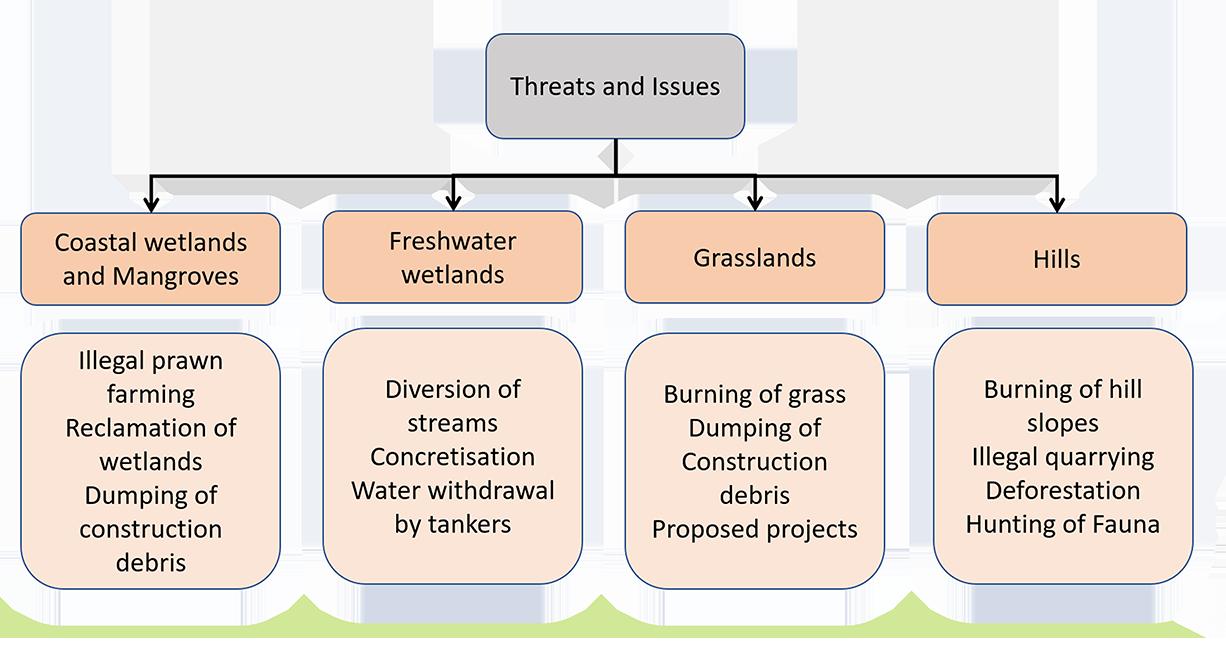
Every year, from December to March, as the grass dries out, hill slopes are burned. Miscreants carry out this action, which entirely wipes out the animal and plant life. The grass, several trees, tiny creatures, insects, lizards, and snakes are all burned alive.
Chapter Six : Kharghar
56
6.4.4. Reclamation of land
The building of the Navi Mumbai airport required the reclamation of substantial wetland areas. Up to 8 metres of landfill have been removed from these areas. We are deal ing with about 1,615 hectares of land, according to wetland conservationist Nandakumar Pawar.


6.4.5. Expansion of golf course
Expansion of the Kharghar Valley Golf Course is being done by CIDCO (KVGC). This expansion will cause total 873 trees removal and flattening of the hill slope which is adjacent to the existing golf course.
Figure 37 : Photo Documentation of the Threats
57
Samvardhana

58 Chapter Seven : Case Studies CHAPTER SEVEN: 07 Case Study 7.1. Case Study Parameters : Criteria: 1. Educational 2. Connect people to nature 3. Regenerative strategies 4. Biodiversity conservation 5. Treatment facilities 6. Animal rehabilitation 7. Research facilities
38 : Case Study Parameters
Figure
7.2.1. Coastal and Marine Biodiversity Centre, Airoli:
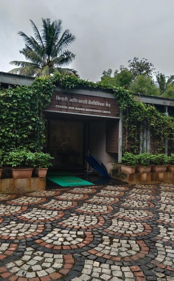
It is the first Coastal and Marine Biodiversity Center in Maharashtra. It was officially opened on April 30, 2017. This centre is situated on the northern bank of Thane Creek, which divides Mumbai from Navi Mumbai, another megacity. Numerous migratory birds and thousands of flamingos make this creek their win ter home. The Maharashtra Government has designated a 1,690 ha tract along the northern portion of This Creek as a wildlife sanctuary in order to acknowl edge these significant tidal wetlands and mangroves.
The CMPA developed this idea for this contemporary interpretation centre with assistance from the Mangrove Cell of the Forest Department with the goal of preserving coastal and marine biodiversi ty. German science and research commu nications firm Archimedes Exhibitions, who were previously involved in the de signing phase of India’s “Science Express” in 2007, have been hired for this project.

59 Samvardhana
Figure 39 : Entrance of the Centre
Figure 40 : Schematic Plan
The ideas and material were created by the Mangrove Cell and Indian subject mat ter specialists, while the design and manufacture were completed in Germany. The idea behind this project was to use a combination of audio-visual, auditory, and tactical aspects into the exhibitions to create a sensual learning experience.To give visitors sensitise beauty of Costal and Marine Biodiversity. At a same time they will be getting information about the importance of Biodiversity and the threats which are faced by Fauna present in the wetlands and mangroves.

Figure 42 : Outdoor Activities

60 Chapter Seven : Case Studies
Figure 41 : Informative Installations
This centre is divided into three parts:
Admin office: 1. ticket Counter 2. Waiting
shop
Outdoor Activities:
1. Mangrove Trail 2. Flamingo Point
Mangrove Nursery
Crab Pond
Board Walk 6. Creek View
Boating for observation
Fish breeding Facility
Whale Bone Exhibition
Inferences:
• Lack of knowledge of the significance and need for protection of biodiversity.
• Human activities are major reasons behind the biodiversity loss.
• Rescue centre are not available near Kharghar hill region (NMMC veterinary services)
• There is a need for research about the local flora and fauna to document the impact of urbanization on them to plan further conservation strategies.
• A platform for the local organizations to spread awareness and organize workshops and activities to restore the damage.
61 Samvardhana
3. Souvenir
4. Admin 5. Office Awareness Center: 1. Reception 2. Lobby 3. Biodiversity Information room 4. Interactive touch screen table room 5. Audio-Visual Room 6. Awareness Room
3.
4.
5.
7.
8.
9.
7.2.2. Habitat for Urban Wildlife, Israel

This project was an award-winning entry submitted by Ifat Finkelman_Ofer Bilik Architects of the competition ‘Water Tower- new perspectives’ organised by the Bezalel Academy of Art and Design, Jerusalem, Berkeley University and the Society for Preser vation of Israel Heritage Sites (SPIHS) in August-December 2010. This competition was about revitalizing the abundant water towers in Israel through various design suggestions which respects and conserve the existing architecture of these towers.
In this design the architects have identified the potential of these water towers with their unique structure, height and location to act as a habitat for urban wildlife. Their obvious features as urban landmarks propose expanding their given function as natural systems.
Figure 43 : Water Tower Illustration
62 Chapter Seven : Case Studies
Figure 44 : Section of Tank wall
This water is a living building which functions as natural systems that creates a balance between the structure and its natural surroundings. According to its location it accommo dates nesting space, hidden areas and food resources to strengthen the natural ecological systems. By studying the biodiversity nearby the water tower the architects have come up with series of openings and voids specifically sized accordingly to allow a rich variety of fauna.

Figure 45 : Plan of water tower

63 Samvardhana
The architects have not only provided space for the fauna but also for people to ob serve these faunas hidden inside the tower without disturbing the various species. a system of staircases and viewing galleries were created inside the tower specifically arranges view ing voids to match the geographical and biological variety.
Hidden viewing platforms, research initiatives, public relations campaigns, nature and art galleries, and other educational services are built to connect people with the envi ronment system.
Figure 46 : Section of tank

64
Chapter Seven : Case Studies
Goals: 1.Protect biodiversity 2. Bringing back species that were once present in the area 3. Using water features to draw migratory birds in the fall 4. Information and education 5. enhancing the site’s visibility and standing in the neighbourhood
Inferences: • Revitalizing the water tower to make home for migratory fauna. • Educating the visitors via creating enclosures inside the water tower to
the
• Saving
by providing
for
• Water resources to attract
observe
birds.
biodiversity
habitat
wildlife.
several fauna.
7.2.3.
Maharashtra
Nature Park,
Mumbai. • With the intention of educating people and raising awareness about wildlife conserva tion, this park was created in 1994. • It is a manmade forest constructed on top of a garbage dumping ground area.
It is also surrounded by the mangroves of Mithi river having rich biodiversity
This park is divided into two sections
Figure 47 : Site Plan of Nature Park

65
Samvardhana
1.
2.
•
1.
2.
3.
4.
5.
6.
7.
8.
9.
10.
•
•
Thick wooded area
Education centre to promote biodiversity conservation
Various activities are organised by the park to create awareness about environmental education
Butterfly garden
Nakshatra van
Rain water harvesting
Wooded area section
Nursery section
Medicinal plants section
Palm section
Fruit tree section
Vermicomposting section
Aromatic and spices section
Observation:
• The education centre has a well-equipped library but they do not let people read any books.
•The activities about awareness, lectures are conducted in amphitheatre and exhibition hall.
• There are various types of seeds on display in the exhibition hall which can be accessed to touch and learn about it.
• Each tree or shrubs present on the nature’s trail has a stone beneath the tree with the name of that species in two languages.
• There were few informative boards at the entrance but not inside the park.
• People needs to hire guid to get information about the biodiversity of the park.

66 Chapter Seven
Case Studies
:
Figure 48 : Unbuilt Spaces
Inferences:
• Group activities and workshops are conducted to attract visitors.
• Nature trail with surrounding vegetation and rainwater harvesting lake along with Mithi river provides a pleasant experience.
• Nursery to engage visitors into ex-situ conservation approach towards biodiversity.

• The water from Rainwater harvesting lake is used for the vegetation in the park
• Native plants are present according to site context.
Figure 49 : Education Centre
67 Samvardhana
7.2.4. VanDusen Botanical Garden Visitor Centre
Architects: Perkins & Will Area: 19483 sq. m. Year of construction: 2011
• In the VanDusen Botanical Garden the visitors started to reduce in early 2005, thus the Vancouver botanical gardens Association found a way to revitalize the garden to attract more visitors locally.
• The architects have approached to design by regenerative strategies.
• To sustain biodiversity, this center’s design strikes a balance between the built environ ment, natural systems, and human systems.
• This structure has certified with LEED platinum rating.
• Its green building strategies and the form is very distinct making it an icon of sustain ability.
Figure 50 : Site plan of Visitor Centre

68 Chapter Seven : Case Studies
Figure 51 : Views of the Visitor Centre

The concept behind the form of the struc ture was inspired by the native orchid. This project has an undulating green roof which is designed according to the need for water harvesting system. And the slopes are directed towards the collection units.


69 Samvardhana
The visitors centre functions on an on-site renewable energy source:
1. Geothermal boreholes 2. Solar photovoltaics
Figure 52 : Energy System and Water System

70 Chapter Seven : Case Studies
3.
4.
Balancing the environment and the built environment. The Visitor Center makes use of nearby renewable resources like solar hot water tubes, geothermal boreholes, and solar photovoltaics in order to achieve net-zero energy on an annual basis. Rainwater is filtered and used to meet the building’s greywater needs, and a bioreactor on site treats all on-site blackwater before releasing it into a new percolation field and garden feature. 5.
Solar hot water tubes
Rain water harvesting
Bioreactor 6. Percolation field
Figure 53 : Detail Section showing the regenerative strategies

71 Samvardhana
Building the Complex Geometry of a Curved Roof. Various 3D modelling technol ogies were used to build the roof’s basic geometry, and then parametric techniques were used to optimise the curvature and arrangement. The structural design was created by the structural engineers using this model, and it was then sent to the fabricators so they could determine the best way to panelize each segment. A post-and-beam structure made of glued laminated wood, also referred to as “glulam,” supports the delicate curves at each panel’s borders.
Inferences:
• To re-engage the visitors this garden was restored with various regenerative architecture strategies.
• It is a perfect example of regenerative architecture.
• The design balances the architecture and landscape to support the native biodiversity.
• It has various regenerative functions which can be followed by architects for future construction.
72 Chapter Seven : Case Studies
Case study Inferences
Criteria
Educational, Connect people to nature, Biodiversity conservation
Educational, Connect people to nature, Biodiversity conservation
Educational, Connect people to nature, Regenerative strategies, Biodiversity conservation, Research facilities
Inference
Educational, Connect people to nature, Regenerative strategies, Biodiversity conservation, Research facilities Case Study Matrix
•Interactive installations to engage the visitors into learning about biodiversity. •Audio visual room for better understanding of various species and their voices and visuals.
Case StudiesParameter
•Various activities are conducted to spread awareness with the school children about conservation.
Local Biodiversity Conservation, Design program identification
Coastal and Marine Biodiversity Centre, Airoli
•Mangrove trail and observation.
• Revitalizing the water tower to make home for migratory fauna.
• Educating the visitors via creating enclosures inside the water tower to observe the birds.
• Saving biodiversity by providing habitat for wildlife.
Architectural Interventions, Organic architecture.
Habitat for Urban Wildlife / Ifat Finkelman_Ofer Bilik Architects
• Water resources to attract several fauna.
• Group activities and workshops are conducted to attract visitors.
• Nature trail with surrounding vegetation and rainwater harvesting lake along with Mithi river provides a pleasant experience.
• Nursery to engage visitors into ex-situ conservation approach towards biodiversity.
• The water from Rainwater harvesting lake is used for the vegetation in the park
Local Biodiversity Conservation, Design program identification, Organic architecture.
Maharashtra Nature Park, Mumbai.
• Native plants are present according to site context.
• To re-engage the visitors this garden was restored with various regenerative architecture strategies.
• It is a perfect example of regenerative architecture.
• The design balances the architecture and landscape to support the native biodiversity.
• It has various regenerative functions which can be followed by architects for future construction.
Architectural Interventions, Regenerative architecture, Design program identification,Organic architecture.
VanDusen Botanical Garden Visitor Centre, Vancouver, Canada.
Table 07 : Case Study Inferences
73 Samvardhana
7.3.
CHAPTER EIGHT:
Issues and Solutions
8.1. Mapping of Kharghar:
A node of Navi Mumbai that is a part of Panvel Municipal Corporation is Kharghar. It is located in Raigad district’s furthest north. The City and Industrial Development Corpo ration produced it (CIDCO). Currently, the recently established Panvel Municipal Corpo ration is in charge of Kharghar. There are presently a range of finished and unfinished projects in both the com mercial and residential sectors since the region started to flourish in 1995. Kharghar is regarded as Navi Mumbai’s third most devel oped node, behind Vashi and Nerul. It seems there is no turning back given the size of the projects being undertaken and the govern ment’s acquisition of all necessary licences.
74 Chapter Eight : Issues and Solutions
08


AREABOUNDARYMUMBAIPROJECT BHOIRPADA RLY.TALOJASTATION NATIONAL HIGHWAY NO4 T0 D V ROAD WIDE ROAD 20.0 OAD WID ROAD WIDE ROAD ROAD ROAD ROA WIDE MSE OWER DER RESAR 18 17 16 19 20 23 24 25 26 NNEL 13.40M HANNEL WIDE NNEL 28 GROUND ROAD ROUND GROU FLOODLINE FLOODLINE 00M existingroad COMMERCIAL BUSha COMM CIAL ha TO DIVA. TANK TO THANE TO THANE PISARL KASABEVALOJE TO PANVEL CENTRAL RAILWAY AREA 50M 100M FOR PROP.METRORAILELECTRICSUB TATON TALOJA-PANCHNAND PH-I GAOTHAN MWIDE ROAD TOTALOJA 11.00M ROAD POWER CORRIDOR CHANN PROP.20.00M TAHLGAOTHA CT R-5 SECTOR-11 SECTOR-10 SECTOR-14 SECTOR-9 SECTOR-4 SECTOR-5 SECTOR-15 EAMUMBAIOUNDARYPROJECTBHOSECTOR-6 IRPADA SECTO 7 SECROR NO.1 STATION FUNCTION AREA T0 I A TALOJA RIVER 1.75ha. SECTOR-12 SECTOR-3 TALOJA PHASE-II SECTOR-2 100 146.95 83.20 CHANN OSECTOR-8 240.39 .93OP. 20M WIDE PROP. ROADROA PROP 20M WIDE PROP TOLOJA RIVER ProposedRailwayStn. HIGHFSI ADJOI NING KALAMBOLI N NH4( POONA THANE HIGHWAY) +6.50M NH4 POONA THANE HIGHWAY) NAWADEVILLAGE NAVDE NONNODALAREA INDUSTRIALTOTALOJAAREA HTL NODALAREA PROP.HOLDINGPOND-1 NODALAREA BUDDHAPADAVILLAGE NODALAREA AREA=4.71HA 6.44HAHOLDINGPOND1&TOTALAREA=12.10HA) FOODLAND NAVDE PROPOSED MARBEL MARKET 42 FLOODLINE@200M SCHOOL GROUND 15.00 WIDE SERVICE ROAD HIGHFSI STATIONFUNCTION HIGHFSI HIGHFSI HIGHFSI HIGHFSI HIGHFSI H W A S R HIGHFSI HIGHFSI HIGH FSI HIGHFSI 42593.19 43169.43 42951.11 61486.53 38600.72 50238.57 18921.52 43071.38 26032.48 18280.46 21756.74 16261.29 32387.39 48079.08 24456.62 3998.94 4998.75 STATIONFUNCTION HIGHFSI HIGHFSI38179.88 91794.60 54372.44 FOODMALL FUELSTA IDGE CENTER 14812.12 15559.01 15185.57 41-1 41-2 41-4 42-1 42-2 42-3 42-4 42-5 43-1 43-2 43-3 43-4 43-5 43-6 43-7 43-8 44-1A 44-2 44-3 44-4 44-5 8694.98 45-2 45-1 3053.14 45-3 45-4 45-5 45-6 45-7 45-8 ROAD COMM+RESI COMM+RESI 24.00 WIDEROAD P.UTILITY TEMPLE ROAD CHANNE ROAD 15.0 WIDE ROAD CENTRE F/15 F/14 F/49F/28F/27F/48 CLUSTER G/60 G/44 G/37 SOCIETY BELT F/72 F/85 F/86 GARDEN GROUND ROAD G/137 F/91 SER.CORRIDOR 28toG/34 G/47toG/58 G/87toG/93 F/33toF/42 F/73 F/81 100.0 WIDECHANNEL TREE KHARGHAR GAOTHAN PLOT SECTOR-13 COMMONPLAYGROUND SUPER SPECIALITY HOSPITAL YERLA MEDICAL COLLEGE CIDCO OFFICE GARDEN N.I.F.T IRWO C+R 26&27 31 33 HOTEL V'PEETH RESI APPARAL EXP.COUNCIL JAWAHAR E.SOC. SERVICE CORRIDOR 15.0M WIDE ROAD M15.0 WIDE ROAD 15.0 WIDE ROAD 15.0MWIDEROAD SCHOOL COMMON PLAYGROUND 15.0MWIDESERVICECORRIDOR LIABRARY 14A 14B 14D OPENSPACE 11.OOM. ROAD 40 50 16A COMMONPG R+C OMMUNIT RESI RESI S.F. S.F. 42A SF SF SF COMM 15.0 WIDE ROAD ROADWIDE INDOOR RECREATION PU PARKING SECTOR-3 32.00 m wide road E-88 E93+94 NO.I/1 E-77&E-78 BALAJI E-36 E-91 E-87+E87A E-82 E99&100 E-11 E/56B+E/56D 35.0 40.00 ROAD HOLDINGPOND 40.0MW DE RO ProposedRailwayStn. ProposedBusStand M Bridge Fire COUNTOURLINE 32.0 M WIDE ROAD PROP.MBR BULK LAND RESIDENTIAL 802.44 SQ.M RECREATIONAL PROP. PROPOSED GOLF COURSE TATA HOSPITAL 17.50M.CHANNELRESERVATION COMM 24.00M. ROAD 3A GARDEN UTI BPCL DEWANHSG. HOTEL STALLS HEALTH 24.00 WIDEROAD 9+12 14 11.00M13ROAD R+C COMM COMM R+C R+C R+C R+C R+C COMM 24.00M ROAD WIDEROAD COMM COMM SIEMENS R+C 11.00m.Service32.00m.widePandav marg 15.00 11.00M OAD 11.00M 35/I 26.00 35/D 35/E11.00 11.00 NODAL COMME CIAL NODAL OMMERCIA 34/B 34/C 35/G 35/F CHOOL 100.00M WIDE M.S.E.B. POWER LINE /PU 11.00 32.00 25.00M RESERVATION SERVICE POWER ROAD 35/H 1-B/21-B/1 34/A PHARSHIPADA 15M 75.00M WIDE RESERVATION POWER CORRIDOR IDENTIAL DEVELOPMENT PROP WIDEROAD 12.5% 12.5 PLAYGROUND FUTURE DEVELOPMENT CORRIDOR RESERVATION SERVATION 75.00M RESERVA TATA SERVI 25+75=100 POWERCORRIDOR WIDE CORRIDOR K H A R G H A R H L MSEB O.INST. ROAD(PROP) 6B RESI. RESI. EXISTING ROAD ROAD(PROP) 15.00M. ROAD PROP.24M.ROAD MSEB PROP.15.0M.WIDEROAD RECEIVING STATION ADDL.PLOT TO Nursary KH-3 KH-6&7 1.0HA. 1.0HA. PROP. ROAD FUT.DEV. (16995.0 M2) 41.00M. WIDE CHANNEL 3A R+C RESI COMM 24.0 ROAD 8ARESI GARDENCUM COMM 4+4A 24.0 ROAD 12B 12A 13,14RESI COMM COMM 15.00M.ROAD 8B 1B (ADDLLANDSTRIP) SCHOOLP.G. M. 24.0 COMM RESI SCHOOL 20 CREMATORIUM PLAYGROUND COMM+RE RESI+COMM. PETHAPADA ROAD ROAD ROADWIDE 120 WIDEROAD WIDEROAD 94&95 9.00M. 154 WIDEROAD RELIGIO 15.0 WIDEROAD 117 SOCIETYROADWIDE PLOTS SOCIETY WIDE ROAD SOCIETYPLOTS 133 GROUND MURBIPADA GAOTHAN WIDE9.00M. 37&38 39B 8TO159 PLAYGROU CHANNEL 144 95C 169A 85A 157+160 124 WIDE ROADWIDE 35.0 R O ESR 9.51Ha. GARDEN 15.0 M WIDE ROAD 5 15.0 M ROAD R+C 15.0M ROAD MSEBSTAFF 15.0 ROAD CENTURY HEDURAWADI CORRIDOR ASHRAM PLANTATIONPLOT FRIENDSHIP PLANTATION AREA UNDER 100M WIDE POWER CORRIDOR PLANTATIONYERLA AREA SARASWATI 6.00M. PROP. HEDUREWADISTRUCTURES 15.00M. ROAD PLANTATION NURSERY PLOTS/ O.SPACE O.SPACE O.SPACE R EXST.CHANNEL ADHIRAJ RESI SARASWATI 20.00 WIDEROAD 15.0 WIDEROAD 12.00M ROAD ROAD COND.A COND.B Futuredevlopment 15.0 WIDE ROAD 20.00 WIDEROAD HOLDING CHANNEL SCHOOL COMM PUMPHOUSE KOPRA 221A 220&221 VILLAGE 104&105 S.F.cultural GARDEN 224 TANK 24.0M.WIDEROAD ROADWIDEM.24.0 NODALAREA NODALAREA NODALAREA 7050 15.00M.WIDEROAD ROADWIDE15.00M 24.00M.WIDEROAD 256+257 261+262 263 258 PLAY (religi.)(CC) 264to266 SCHOOL PLAYGROUND 209 176+178 188A 212+212A 213 40.0 WIDE 11.00M. ROAD 109 S.F. S.F. 253+254+269 255 249 ROADWIDEPROP.15.00M248 271A 8M.ROAD 271B 233 260 HOSPITAL HA)SUPERSPECIALITY 206 227 226A 1100 BELT Proposedlocationrelocation existingcrematorium 15.0 WIDESERVICECORRIDOR GROUND 40.0 CHANNELWIDE POND 273 15.00M.WIDEROAD 214 FUTURE EVELOPMENT 20.00 women's 35.0 WIDE ROAD 15.0 ROAD GAEDEN ROAD WIDEROAD SCHOOL ROAD PLAYGROUND WIDE 24.75M ROAD(PROP.) SER. PATHWAY 15.00M.ROAD 40.00 WIDEROAD CENTRAL PARK 23 29 32 25 21 20 19 12 13 14 18 17 16 15 10 9 8 7 11 4 5 6 2 1 3 22 26 27 30 36 39 40 41 42 43 44 45 KHARGHARRLYSTN MUMBAI-PUNE-GOAHIGHWAY OWE PETHAPADA RANJANPADA CORPORATE PARK RAF CORPORATE PARK CORPORATE PARK CORPORATE PARK HA PROPOSED METRO STATION 5.00 METROPROPOSEDSTATION GOVT.WELFARE GARDEN 55+56 67&68 GARDEN GARDEN R+C SF 45.00M. WIDE CHANNEL 11M.RD 15.00M.ROAD 15.00M.WIDEROAD WWH 10M. CHANNEL WIDE RVICEROAD 11.0MWIDESERVICEROAD OWE 163A 163B 163C UTUR DEVEL ROAD ROAD COND-4 CORRIDOR proposedmetroroute CORRIDOR +8.100M 27 ROAD 20.0 HOLDINGPOND AREA7.2HA 15.00MT ROAD 20.0 ROAD ROAD 20.0 ROAD 21 30MD.P.ROAD 10.5M 30.0 channel 21.0mchannelres. CIDCOMASSHOUSING P.NO.1 35.0 RES VATION OR HANNE 0. ROAD 20 MROAD CIDCOMASSHOUSING P.NO.1 22 243.52 173.1 495.94 48.74 100.03 36.00 3 35.00 WIDE OAD CHANNEL PondB WetPond PondA CREEK MNG RLY PBL RIVER 46527.62 CENTRAL PARK CENTRAL PARK 24 33 28&31 wide WIDE CORRIDOR MT. 21.00 ADDED I N P U S H P A K N O D E RECREATIONAL ZONE KHARGHARHILLPLATEAU. SCIENCE PARK PROP. CONNECTIVITY PHYSIBILITY MAY BE EXPLORED EHVT .0M. WIDE ROAD 35.0M. WIDE ROAD RO MWIDEROAD 45.00 WIDEROAD 20. IDEROAD 208.07 419.42 78.99 110.46 45.M.WIDE ANNEL TRO RECO AREA WIDE DRAIN 37 38 HOUSING NMDP BOUNDARY Hous R+C 100.00M WIDE M.S.E.B. ROADWIDE40.00M. 20.00M. CHANNEL PROP.9.00M. SERVICE ROAD SERVICE CORRIDORE (MINIMUM WIDTH=8.0 NURSERY SWITCHING STN. SUB-STN. STP pathway EXST.CHANNEL COMM 24.00M. WIDE ROAD 15.0MROAD 6.0 WIDEPARKING 15.0MROAD PARKING 26A 23A CENTRAL EXCISE 11A GARDEN 15.00 WIDEROAD 15.0 WIDE ROAD YUVA PLANTATIONAREA 10.0 WIDECHANNEL MUSEUM 11B C+R POLICE COMMERCIAL PLANTATIONAREA 20A 30B 15.00 WIDE ROAD RESI RESI RESI R+C R+C R+C R+C R+C R+C R+C R+C R+C R+C R+C R+C PU COMM 18.0MSERVICECORRIDOR road 113751.00 Nursary 45.00M.WIDE FUTURE DEVELOPMENT DRC DRC PAPADICHAPADA HOLDING HOUSING 10A 40 39-B 39-C 39-D RCIAL 26.38 160.65 40 POND A-3/2 conf channel SERVICE INDUSTRY SERVICE INDUSTRY SERVICEINDUSTRY STATION FUNCTION AREA TO PANVEL SERVICE INDUSTRY PUSHPAK NAGAR PYLONS) R+C FUTUREDEVELOPMENT BUFFER ZONE COND.C COND.D 20.0M.WIDEROAD 45.00 WI ROAD 0.00MWIDEROAD 24.00 WIDE ROAD 32.00 WIDEROAD LIG-EWS HOUSING 100.M. O E R 12.5% AREA HOSPITAL VALEEYSHILP A D J O I N I N G NMDP BOUNDARY 10M.WIDEROAD RESI RESI RESI RESI RESI RESI RESI RESI SEMIDETACHEDBUNGLOW DETACHEDDETACHEDBUNGLOW BUNGLOW SEMIDETACHEDBUNGLOW 12.5%AREA 12.5%AREA AREA 12.5% AREA 12.5% AREA 12.5% AREA 12.5% AREA 12.5% AREA 12.5% AREA 12.5% AREA 12.5% AREA 12.5% AREA 12.5% AREA 12.5% AREA 12.5% AREA 12.5% AREA 12.5% AREA C+R SER.CORRIDOR SER.CORRIDOR 45.00M.WIDEROAD 15.00 WIDEROAD WIDEROAD FUTURE DEVELOPMENT WIDEROAD 12.5% AREA STATIONAREA CRZLINE VILLAGE X X X X X X X X X X X X X X X X X X X X X X X X X X X X X TRANSPARENT WALL ALONG ROAD EXISTING SETTLEMENT HOUSING COMPOUND ALONG 24MTS WIDE ROAD CLUB BUNGLOW F/88A CPG HIGH YUVA NAVDE-KILPADA STP DIVAPANVEL RAIL LINE PUMPHOUSE SUBSTATION propose 7.99 RESERVE BANK OF INDIA BHARATI VIDYAPITH RING ROAD T.I.F.R. 2 3 3CCOMPOSITE 3B DENTAL PLAYGROUND SIONPANVELEXPRESSHIGHWAY SCHOOL 7 1 4 alignment proposedalignment STALLS BAZAR PU (GharkulMassHsg) 223B 223D 3 4 PRPO.8.00M. SERVICE 12+13 56 10&11 37 RAILWAYRESERVATION VERIFIED SITE 11.00M. 195.31 29 CIDCOMASSHOUSING 24M.PROPO ED ROAD poojaparking parking 10.00 mandap 122.13 30.23 120.79 96.66 136.79 EHV STATION TotalApprox5.6 P.No. 2 P.No. 135.041 36A 139.37 42A 135.041 148.1031 148.1031 24.00 WIDE ROAD 24.00 DE RO WIDE DRA
The
and subject to minor
CIDCO Ltd. CITY AND INDUSTRIAL DEVLT.CORPORATION OF MAHARASHTRA Ltd. C.B.D., BELAPUR DATE 09.06.2017 SCALE 1 4000 DRAUGHTSMAN (KHG) DY..PLANNER (S) ASSOC PLANNER (S) SR. PLANNER (S) ACP (NM) CAP N KHARGHAR NODAL PLAN Figure 54 : Kharghar Nodal Plan
NOTE:1.
locations are indicative
modifications without compromising the areas. 2. This Plan is issued for your information only and should not be used for any other purpose. 3. Final boundary of plots shall be as per agreement drawing of individual plots.Only Indicative boundaries are marked on plan 4. In areas not yet detailed out, minor variation in area and location may take place while finalizing the layout. 5. The uses indicated are NOT statutory RESERVATIONS as per MR &TP Act 1966 6. Any discrepancy observed in terms of location, plot no, area may be brought of the notice of Planning Department
8.1.1. Kharghar Future Developments
The future developments are moving towards the hill and the wetlands, as can be seen by looking at Kharghar’s development plan.
• Future residential development areas surround the tiny villages on the Kharghar hills like Fanaspada and Chapevadi, which will enhance traffic and human movement there.
• The open space in front of Pandav Kada Falls has been granted to a future residential zone, which will disrupt the natural green corridor between the Kharghar hills and marsh es.
• There is an expansion of the golf course taking place towards the hill, chopping down many trees.
• Immediately adjacent to this quarry, where you can see the dust contaminating the hill sides from a distance, is an operating quarry.
76 Chapter Eight : Issues and Solutions
8.1.2. Kharghar Topography Map :


Figure 55 : Kharghar Topography Map

77
Samvardhana
8.1.3. The critical zones of Kharghar:
Figure 56 : Critical Zones of Kharghar

8.2.1. Stone Quarry 8.2.2. Deforestation
8.2.3. Burning of grasslands 8.2.4. Reclamation of land 8.2.5. Expansion of golf course 8.2.6. Airport corridor
78 Chapter Eight
and Solutions
: Issues
8.1.4. Master Plan for Green Spaces :
this is the first “Master Plan” built only for “Greens”. This plan is devoted to the 55% of the land of the Navi Mumbai project that is set aside for open-sky users. The plan ad dresses environmentally delicate locations such as regional parks, mangroves, places under high tension lines, and hill slopes. To create a network of open spaces throughout the city, an effort has been made to connect these places with the green spaces found within the nodes. According to this plan, 25 theme parks have been chosen, each of which is dedi cated to a particular theme while taking into account the site’s existing characteristics, the area around it, and the needs of the city.
Figure 57 : Master Plan for Green Spaces in Kharghar

79 Samvardhana
8.2.1. Regenerative architecture:

Figure 58 : Regenerative Graph
Regenerative design interventions can be used in architecture to lessen the impact of grey infrastructure building on the environment and biodiversity. Engaging nature as a medium to create and provide good influence on their surrounding ecosystems is the goal of regenerative architecture. It necessitates a thorough comprehension of the ecosystem’s functioning. Buildings must be exposed to the outside in order to create cities that are integrated with nature and connect people to the natural world.
Buildings inspired by nature grow more significant as cities become hotter and more polluted. They can lessen the impact of harsh external temperatures and cut down on energy use in buildings. Despite the dynamics of climate change, well-considered solutions will control temperatures to support biodiversity and the health of local ecosystems.
80 Chapter
Eight : Issues and Solutions
8.2.2. Renewable resources:

Figure 59 : Renewable Resources
When a building is designed with a net zero energy footprint, the quantity of energy it uses and the amount of energy it produces are equal. Buildings account for 40% of all energy use, and while it’s fantastic to reduce their impact by achieving a net zero effect or designing sustainably, they can do more. It’s possible to challenge buildings to cause the least amount of harm while achieving the greatest amount of good.
81 Samvardhana
8.2.3. Alternative Construction Materials :
1. Bamboo: One of the best environmentally friendly building materials is bamboo. It has an astonishingly rapid rate of self-generation; some have reportedly grown up to three feet in just 24 hours. After harvest, it keeps extending and expanding without needing to be replanted. Additionally, it is extremely durable, has a high strength to weight ratio, and even more overall strength than brick and concrete. Therefore, it is the ideal option for both flooring and construction.

2. Sun Dried Bricks and Plaster: One of the oldest building materials, sun-dried clay has been used to construct homes, mosques, cathedrals, castles, and towns for more than a millennium. Currently, one-third of the world’s population resides in homes built using the artificial stone-like building material. This building material, which is typically formed from a combination of clay and organic components, is resistant to weathering and lengthy periods of time. When used properly, the method for manufacturing clay has nu merous advantages, including being readily available locally, being affordable, and having good thermal and acoustic insulation. As a result, earthen building has several benefits in terms of sustainability. These days, using this environmentally friendly building material could be a practical solution to climate change.
3. Recycled Steel: 98% of all structural steel is recycled back into new steel products at the end of a building’s lifespan without losing any of its original physical characteristics. Because it can be recycled again, structural steel is “multi-cycled,” as opposed to just being recycled. This material actually lasts from cradle to grave.
4. Recycled Plastic: Energy and landfill space are saved by recycling plastics. Every day, recycled plastics are employed in brand-new building and construction projects. To cut costs without compromising performance, recycled plastics can be used with virgin plastic (plastic that has not been processed before). By creating polymeric timbers from such discarded plastics, which may be used for anything from fences to picnic tables, we can conserve trees. Even carpet is made from plastic from two-liter bottles; this is another recycled product option for our houses.
82 Chapter Eight : Issues and Solutions
Figure 60 : Materials
8.2.4. Two birds, one stone:
Reusing materials in Buildings
• Solar Panels
• Smart Glass Windows
• Composite Roofing Shingles
• Sun dried bricks
• Mud plaster
• Bamboo
• Stone (On site)
• Recycled steel
• Environmentally Friendly Insulation
8.2.5. Maximize “free energy”:
On site renewable energy:
• Photovoltaics (PV): PV systems use solar cells to directly turn sunlight into electricity. These systems, which can create power even when there isn’t much sunshine, can pro duce a lot of electricity depending on a number of variables, including the sunlight’s quality and the pitch at which the device is installed.
• Wind: In places with sufficient wind resources, on-site wind energy generation utilis ing wind turbines can be very cost-effective.
Figure 61 : Energy Pyramid

83
Samvardhana
8.2.6. Rain water harvesting:
Rainwater harvesting is the technique of gathering and storing rainwater using artifi cially constructed systems that run from naturally occurring or created catchment areas, such as roofs, buildings, rock surfaces, hill slopes, or artificially repaired impermeable or semi-pervious land surfaces.

• Catchment: Used to gather and keep rainwater in storage.
•
• Conveyance system: This system is used to move the water that has been gathered from catchment to the refill zone.
•
• The first rainstorm is flushed out using this technique.
•
• Filter: Used to remove impurities from rainwater that has been collected.
•
• Tanks and recharging structures: they are used to hold the ready-to-use filtered water.
84 Chapter Eight : Issues and Solutions
Figure 62 : Rainwater Harvesting
8.2.7. Closed loop system:
Every ecosystem niche in the natural world contains closed loop cycles. A closedloop cycle is a system where nothing is lost and everything is recycled back into the cycle to support and improve it.

Figure 63 : Closed Loop System
8.2.8. Vermicomposting:
Compost is produced by red worms in bins as they consume food scraps, yard waste, and other organic material. This substance is broken down by the worms into castings, a superior kind of compost. Worm bins are simple to build and can be bought as well. A mature worm population of one pound (or roughly 800-1,000 worms) can consume up to half a pound of organic matter every day. The bins can be adjusted in size to accommodate the quantity of food waste that will be used to make castings.
Producing acceptable castings normally takes three to four months. You can use the castings as potting soil. Worm tea, another consequence of vermicomposting, is a premi um liquid fertiliser for gardens or indoor plants.
85 Samvardhana
Figure 64 : Farming
Vertical farming : Growing crops ver tically stacked is known as vertical farming. It also offers farming in a regulated setting. Vertical farming aims to produce the best crop growth possi ble. There are also methods for growing things without soil, like aquaponics, aeroponics, and hydroponics. All of these are instances of urban agricultural techniques.
Rooftop gardens : It is a garden located on a building’s rooftop. Rooftop gardens offer functional benefits such as climate control, architectural improvement, ani mal corridors, habitats, and recreational activities. The main benefit of rooftop gardens is that they provide food. So recently, it has become a popular urban farming technique.

Greenhouse farming : It’s a way of growing fruits, vegetables, and other things in a greenhouse. Farmers can boost their performance and produc tivity with the aid of greenhouse farm ing. Additionally, it shields pants from outside dangers like vermin and bad weather. Greenhouse farming refers to the practise of agriculture in public, private, and shared urban areas. As a result, greenhouse farming is a fantastic business idea for urban farmers.
Aeroponic systems : In aeroponic systems, plants are only fed by nu trient-rich mist. Aeroponic systems involve “planting” seeds within foam pieces that are stuffed into tiny pots and exposed to light and nutrient spray on opposing ends. The foam also holds the stem and root mass in place as the plants grow.
86 Chapter Eight : Issues and Solutions
8.2.9. Farm-to-Table:
Varied people will have different interpretations of the phrase “farm to table.” Fun damentally, “farm-to-table” refers to the fact that the food was obtained straight from a particular farm, bypassing any distributors, markets, or retail outlets.

In some cases, Farm-to-table dining, can practised during Outstanding In the Field events, meaning that the table is actually at the farm and that the meal is prepared and served there (even in the field). A tour of the farm is frequently provided, during which the farmer displays and describes the techniques employed in the production of the meat, poultry, fruits, and vegetables. These dinners are instructive and include as many locally sourced and seasonally appropriate ingredients as possible.
8.2.10. Urban Beekeeping:
The activity of working with bees in cities is known as urban beekeeping. In addition to honeybees, this can also apply to solitary bees like mason, leaf cutter, and digger as well as some social bees like carpenters and bumbles. Because of the long history of the occupation, which dates back more than 9,000 years, most people work with honeybees. Similar to rural and suburban beekeeping, urban beekeeping with honeybees entails starting colonies with queens and worker bees, housing them, giving them extra food when necessary, assisting them in fending off pests, and gathering honey when there are surpluses.

87 Samvardhana
Figure 65 : Farm to Table Concept
Figure 66 : beekeeping
8.2.11. Waste Management:
Figure 67 : Waste Management
8.2.12. Sewage Treatment Plant (STP)
The process of purifying sewage water and reusing it for gardening, agriculture, and other general purposes is known as a sewage treatment plant (STP). Purification and upkeep standards for treated sewage water are set by the Pollution Control Board. In the majority of industries, housing colonies, and flats, STP are required.

88 Chapter Eight
Issues and Solutions
:
8.2.12. Green infrastructure:

A porous urban surface made of openpore pavers, concrete, or asphalt with an un derlying stone reservoir is known as perme able pavement. Permeable pavement collects surface runoff and precipitation, holding it in a reservoir while allowing it to gently seep into the ground below or out through a drain tile.
Figure 69 : Bioswales
In a small depression, usually created on a natural slope, native plants, perenni als, and flowers are planted. It is intended to catch and soak up rainwater runoff that comes from roofs, roads, patios, or lawns for a short period of time. Up to 90% of nutri ents, pollutants, and up to 80% of sediment can be effectively removed from rainwater flow using rain gardens. Rain gardens allow approximately 30% more water to percolate into the soil than a typical grass does.

Figure 68 : Permeable Pavement
Bioswales are planted depressions that are only a few feet deep and covered with vegetation that are designed to absorb, treat, and permeate stormwater runoff as it travels downstream. They are frequently made to handle the “first flush,” also known as the “water quality event,” which is the initial and frequently most contaminated amount of water after a storm.
Figure 70 : Rain Garden

89 Samvardhana
8.3.1. Need of Research Centre:
Successful human-animal conflict avoidance must be founded on thorough localised research of the species at issue and the precise locations where these conflicts take place. In order to solve the aforementioned issues, the research will intend to gather and analyse wild animal rescue records from the state forest department offices, volunteers, and NGOs in Navi Mumbai, With the help of this Research centre, researchers and decision-makers will have new opportunities to keep accurate records of urban biodiversity and to suggest viable management strategies for it. Additionally, it will promote new conservation volun teers and raise public awareness of the value of regional biodiversity.
Figure 71 : Need of Research Centre

90 Chapter Eight : Issues and Solutions
8.3.2. Need of Awareness Centre:
• Lack of knowledge of the significance and need for protection of biodiversity.
• Human activities are major reasons behind the biodiversity loss.

• Rescue centre are not available near Kharghar hill region (NMMC veterinary ser vices)
• There is a need for research about the local flora and fauna to document the impact of urbanization on them to plan further conservation strategies.
• A platform for the local organizations to spread awareness and organize workshops and activities to restore the damage.
Figure 72 : Need of an Awareness Centre
91 Samvardhana
Ecosystem is a vital part of the biodiversity. degra dation of these ecosystems causes by unplanned develop ments in urban areas. The consequences are seen through the climate change and various other inputs The rate of this degradation is rising so, as the global temperature which could create an environmental imbalance.
Environmentalist’s states that society need to be edu cated about this state of the urban biodiversity. The studies state that today 55% of world’s population lives in urban areas. and it is expected to increase which makes the spread ing development consume the remaining green open areas with its biodiversity.
Cause biodiversity is depended on two factors 1) Food 2) habitat and these green areas are the source of both. Awareness of such issues can help improving natural bio diversity by getting people together for various awareness campaigns which focuses on restoration projects.
In India, the loss of biodiversity has increased, espe cially close to metropolitan areas. cause of lack of knowl edge about protecting urban biodiversity. The loss has progressed to the point that urban ecosystems are in a state of decline. Government efforts to restore the biodiversity hotspots in urban areas like Mumbai and Navi Mumbai have been scant, which has resulted in an unsettling situa tion.
According to a study from IIT Bombay that was released in 2020 In the past 40 years, Mumbai has lost 60% of its green space, which has had an impact on biodiversity.
If this condition needs to be changed by embracing Sustainable urban development people need to come to gether to engage into several activities to conserving local biodiversity.
For overcoming these issues, a mass awareness of bio diversity conservation needs to be generated to be educate the city dwellers regarding the need of Urban biodiversity and its advantages and the strategies. This could help into reversing the damage by the Urbanization.
92 Chapter Eight : Issues and Solutions
Synthesis
The aim of this project was to bring forward the threats which the urban biodiversity faces and the strategies which can be conducted to preserve the flora and fauna by spreading awareness among the masses. After studying the urban context of Mumbai and Navi Mumbai it is realized that one of main reason causing the threat to biodiversity, is because of the lack of knowledge of the significance and the need of urban biodiver sity. The rate at which the city is spreading has caused so many species to migrate from their homes, which also causes many animals entering on public spaces and roads causing accidents and injuries to the fauna.
Human activities are the major reasons for biodiversity loss. Hence the design aim to collaborate with different activi ties under one roof which provides knowledge and research and rescue facilities. Through this program a proper research and documentation can be done to track the biodiversity loss and come up with strategies to save the flora and fauna. The design will give a platform for various organizations and NGOs to come together to conduct various workshops to encourage people to contribute towards environment.
The city growth cannot be stopped but as an architect a green approach to design can be followed. There are various technologies have come up in construction industry. One of the approaches to design is regenerative architecture. Through which a structure can be designed in a way that it is net zero as well as it gives back to nature for what it takes to construct it. There are many ways to explore and choose from. A regener ative structure can be a good example for people to learn and take into consideration for future constructions. The structure won’t do any harm to the biodiversity and environment and also spread awareness among individuals to build a new future for the urban biodiversity.
93 Samvardhana
CHAPTER NINE:
DESIGN PROGRAM
9.1. Architectural Proposal:
A Research and Awareness centre which rejuvenates the biodiversity and caters as a learning space having various activities where people can come and participate to help re store the vanished green spaces. Creating an experience of walking in a park while people will get to interact and learn more about their surrounding biodiversity. These interactions will lead to a change in the lifestyle of urban community and with their help smaller steps can be taken on a local level and grown it towards a bigger change into regeneration of urban biodiversity.
Considering the previous chapters inferences and conclusions an architectural program is drafted having a combination of various spaces. Which are further divid ed into these categories: 1. Awareness Centre
Research Centre
activities
94 Chapter Nine : Design Program
09
2.
3. Agriculture 4. Community 5. Recreational
9.1.1. Activities :
Activities that will help the visitors to learn about urban biodiversity through interac tions with their surroundings.
• Community farming
• Composting unit
• Farm-to-table restaurant
• Seed banks
• Plant Nursery
• Botanical garden
• Observatory
• Farmer’s market selling vegetables, flowers & sustainable products.
• Environmental Workshops
• Hiking / Nature’s trail
• Recycle bins
• Volunteer work
• Cycling
• Camping
• Boating
9.2. User Profile:
As the intervention is about biodiversity research and awareness the user demo graphics is a wide range from students to local individuals of Kharghar. The primary users will be researchers, localists and staff. Secondary users will be students and tourists.
Figure 73 : User Profile

95 Samvardhana
Design Program:
Sr. No. No. of UsersOpenSemi-OpenClosed
Programme
Reception / Waiting 2 Laboratory 10 Work stations 10 Library 30 Herbarium 5 Pathology 5 Animal Refuge and treatment 10 Storage 2 office 5
Community farming 50 Butterfly Garden 100 Recycle unit 5 Farmer's market 40 Seed Bank Beekeeping 4 Amphitheater 100 vermicomposting 4
Exhibition space 80 Museum 50 A. V. Room 50 Workshop Space 100 Observatory 10 Botanical Garden 50 Plant Nursery 50 Souvenir Shop 5
Staff Dormitory 20 Camping Visitors 20
Dinning for staff 50 Dinning for Visitors 100 Kitchen 5 Storage 2
Director's Cabin 2 Office 5 Maintenance office 5 Storage / Record Room 2
Substation / D. G. room Control Room Waste Management System (Septic Tank,Composting unit, Recycle waste) Renewable energy ( PV Cells ) Rain Water Harvesting Water Management
Table 08 : Design Program
96 Chapter Nine :
Program
Design
4 Services 7 Restaurant 5 Admin
6 Accommodation
Research centre 1 Awareness Centre 3 2 Activity Spaces 9.3.
Table 09 :
97 Samvardhana
1. Research centre • Laboratory • Animal Refuge and treatment • Library • Work stations 2. Awareness Centre • Exhibition space • Museum • A.V. Room • Observatory • Workshop space 3. Farmer’s Market 4. Administration 5. Restaurant 6. Accommodation Unbuilt Spaces: 1. Community Farming 2. Bee yard/ Apiary 3. Plant Nursery 4. Composting unit 5. Seed bank 6. Amphitheatre 7. Botanical Garden 8. Nature Trail 9. Rain Garden 10.camping 9.3.1. Built and Unbuilt Spaces
Built Spaces:
:
Built and Unbuilt Spaces
Bibliography :
1. https://mumbai.citizenmatters.in/navi-mumbai-biodiversity-zones-kharghar-wet lands-25776
2. https://india.mongabay.com/2021/01/urban-projects-human-settlements-close-in-onmumbais-bird-habitats/
3. https://www.asianage.com/metros/mumbai/100719/infra-projects-led-to-khargharflood.html
4. https://www.hindustantimes.com/mumbai-news/quarrying-destroys-green-navi-mum bai-hill/story-B65WUmstCg0TnihbrZBwUP.html
5. https://medium.com/@khargharwetlands/the-critical-nature-of-kharghar-wetlandshills-8a5bdd37a193
6. https://www.hindustantimes.com/cities/mumbai-news/residents-unite-to-conserve-na ture-help-in-restoration-of-kharghar-hill-101655221207764.html
7. https://timesofindia.indiatimes.com/city/mumbai/quarrying-spins-out-of-control/arti cleshow/6225125.cms
8. https://mumbai.citizenmatters.in/threats-to-the-ecosystem-of-the-wetlands-of-khar ghar-24095
9. https://richmondvale.org/blog/effects-urbanization/
10. https://www.srs.fs.usda.gov/pubs/ja/2016/ja_2016_zipperer_001.pdf
11. https://timesofindia.indiatimes.com/city/navi-mumbai/forest-dept-pitches-for-a-na ture-trail-on-kharghar-hill/articleshow/91527500.cms
12. https://www.freepressjournal.in/mumbai/conserve-kharghar-dps-wetlands-too-forair-safety-bnhs
13. https://www.researchgate.net/publication/233759909_Mitigation_measures_to_re duce_impacts_on_biodiversity
14. https://byjus.com/question-answer/the-three-categories-of-arguments-for-biodiver sity-conservation-are-narrowly-utilitarianbroadly-utilitarianethical-argumentnon-ethi cal-argument/ 15. https://phys.org/news/2022-03-human-decreases-survival-displaced-wildlife.html 16. https://onlinelibrary.wiley.com/doi/abs/10.1002/9781119807216.ch13 17. https://www.trawel.co.in/city/Navi%20Mumbai/coastal-and-marine-biodiversity-cen tre-airoli 18. https://timesofindia.indiatimes.com/city/mumbai/nature-park-for-navi-mumbai/arti cleshow/5011827.cms 19. https://niua.org/cidco/wp-content/uploads/2015/11/development-timeline-of-navi mumbai.jpg
20. https://www.archdaily.com/974707/biodiversity-in-urban-environments#:~:tex t=Architecture%20can%20contribute%20to%20fostering,recycled%20waste%20are%20 also%20important.
21. https://www.thenbs.com/knowledge/biodiversity-the-new-challenge-for-architecture 22. https://www.ansgroupglobal.com/blog/importance-biodiversity-urban-areas
98 Chapter Nine : Design Program
23. https://e360.yale.edu/features/habitat-on-the-edges-making-room-for-wildlife-in-anurbanized-world 24. https://iscnagpur.ac.in/study_material/1.8_SAK_Conservations_of_Biodiversity_ EX-SITU_IN_SITU%5b1%5d.pdf 25. https://www.themightyearth.com/urban-biodiversity-in-india/ 26. https://www.idaindia.org/navi-mumbai-centre 27. https://www.nmmc.gov.in/navimumbai/assets/251/2020/02/mediafiles/ESR_201819_English.pdf 28. http://icrier.org/pdf/erach_bharucha.pdf
99 Samvardhana
Table of figures :
Figure 01: Butterfly, Image Source: Author
Figure 02: Methodology Flow Chart, Image Source: Author
Figure 03: Literature Review Parameters, Image Source: Author
Figure 04: Impacts of Urbanization on Nature, Image Source: Author
Figure 05: Green Area Network, Image Source: mumbaifirst.org
Figure 06: Development of Navi Mumbai, Image Source: pdf4pro.com
Figure 07: Navi Mumbai green Area, Image Source: mapsofindia.com
Figure 08: Migratory Route, Image Source: mapsofindia.com
Figure 09: Biodiversity Loss, Image Source: Author
Figure 10: Biodiversity Services, Image Source: Author
Figure 11: Types of Biodiversity, Image Source: pinterest.com
Figure 12: Biodiversity types and conservation approaches, Image Source: Author
Figure 13: Biodiversity Conservation, Image Source: Author
Figure 14: Various types of Species in Mumbai, Image Source: mumbai.citizenmatters.in
Figure 15: Biodiversity Hotspots in Mumbai, Image Source: Author
Figure 16: Biodiversity Map of Mumbai, Image Source: illustrated by Rohan Chakravarty
Figure 17: Article Collage, Image Source: mumbai.citizenmatters.in
Figure 18: Site Option Matrix, Image Source: Author
Figure 19: Site Demarcation on base map, Image Source: Author
Figure 20: Site one, Image Source: Author
Figure 21: Site two, Image Source: Author
Figure 22: Site three, Image Source: Author
Figure 23: Site Plan, Image Source: Author
Figure 24: Site Analysis, Image Source: Author
Figure 25: DP Plan, Image Source: nmmc.gov.in
Figure 26: Site Views, Image Source: Author
Figure 27: Site Vegetation, Image Source: Author
Figure 28: Natural water Runoff on Site, Image Source: Author
Figure 29: Site Dimensions & Sections, Image Source: Author
Figure 30: Survey Pie Charts 1, Image Source: Author
Figure 31: Survey Pie Charts 2, Image Source: Author
Figure 32: Ecosystems of Kharghar, Image Source: Author
Figure 33: Biodiversity present in Kharghar, Image Source: YouTube, Tranag Sarin
Figure 34: Central Park, Kharghar, Image Source: nmmc.gov.in
Figure 35: Kharghar Positives and Negatives, Image Source: Author
Figure 36: Threats and Issues in Kharghar, Image Source: Author
Figure 37: Photo Documentation of the Threats, Image Source: mumbai.citizenmatters.in
Figure 38: Case Study Parameters, Image Source: Author
Figure 39: Entrance of the Centre, Image Source: Author
Figure 40: Schematic Plan, Image Source: Author
Chapter Nine : Design Program
100
Figure 41: Informative Installations, Image Source: Author
Figure 42: Outdoor Activities, Image Source: Author
Figure 43: Water Tower Illustration, Image Source: ArchDaily
Figure 44: Section of Tank wall, Image Source: ArchDaily
Figure 45: Plan of water tower, Image Source: ArchDaily
Figure 46: Section of tank, Image Source: ArchDaily
Figure 47: Site Plan of Nature Park, Image Source: Author
Figure 48: Unbuilt Spaces, Image Source: Author
Figure 49: Education Centre, Image Source: Author
Figure 50: Site plan of Visitor Centre, Image Source: ArchDaily
Figure 51: Views of the Visitor Centre, Image Source: ArchDaily
Figure 52: Energy System and Water System, Image Source: ArchDaily
Figure 53: Detail Section showing the regenerative strategies, Image Source: ArchDaily
Figure 54: Kharghar Nodal Plan, Image Source: nmmc.gov.in
Figure 55: Kharghar Topography Map, Image Source: World GIS
Figure 56: Critical Zones of Kharghar, Image Source: Author
Figure 57: Master Plan for Green Spaces in Kharghar, Image Source: nmmc.gov.in
Figure 58: Regenerative Graph, Image Source: pinterest.com
Figure 59: Renewable Resources, Image Source: pinterest.com
Figure 60: Materials, Image Source: pinterest.com
Figure 61: Energy Pyramid, Image Source: pinterest.com
Figure 62: Rainwater Harvesting, Image Source: pinterest.com
Figure 63: Closed Loop System, Image Source: Author
Figure 64: Farming, Image Source: pinterest.com
Figure 65: Farm to Table Concept, Image Source: pinterest.com
Figure 66: beekeeping, Image Source: pinterest.com
Figure 67: Waste Management, Image Source: pinterest.com
Figure 68: Permeable Pavement, Image Source: pinterest.com
Figure 69: Bioswales, Image Source: pinterest.com
Figure 70: Rain Garden, Image Source: pinterest.com
Figure 71: Need of Research Centre, Image Source: Author
Figure 72: Need of an Awareness Centre, Image Source: Author
Figure 73: User Profile, Image Source: Author
List of Tables :
Table 01: Negative Impacts of Urbanization
Table 02: The Vanishing Biodiversity zones of Navi Mumbai
Table 03: Mitigation Measures
Table 04: The diverse species existing in Kharghar
Table 05: Site Selection Parameters
Table 06: Site Comparison Matrix
Table 07: Case Study Inferences
Table 08: Design Program
Table 09: Built and Unbuilt Spaces
Samvardhana
101