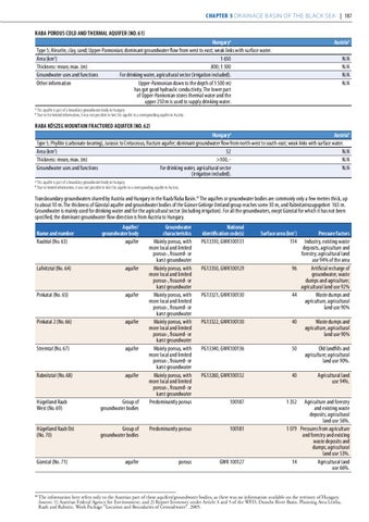
Chapter 5 Drainage basin of the Black Sea | 187 RABA POROUS COLD AND THERMAL AQUIFER (NO. 61) Hungarya Type 5; Aleurite, clay, sand; Upper-Pannonian; dominant groundwater flow from west to east; weak links with surface water. 1 650 Area (km2) Thickness: mean; max. (m) 800; 1 500 Groundwater uses and functions For drinking water, agricultural sector (irrigation included). Other information Upper-Pannonian down to the depth of 1 500 m) has got good hydraulic conductivity. The lower part of Upper-Pannonian stores thermal water and the upper 250 m is used to supply drinking water. a b
Austriab N/A N/A N/A N/A
This aquifer is part of a boundary groundwater body in Hungary. Due to the limited information, It was not possible to link this aquifer to a corresponding aquifer in Austria.
RABA KŐSZEG MOUNTAIN FRACTURED AQUIFER (NO. 62) Hungarya Austriab Type 5; Phyllite (carbonate-bearing), Jurassic to Cretaceous, fracture aquifer; dominant groundwater flow from north-west to south-east; weak links with surface water. 52 N/A Area (km2) Thickness: mean, max. (m) >100, N/A Groundwater uses and functions For drinking water, agricultural sector N/A (irrigation included). a b
This aquifer is part of a boundary groundwater body in Hungary. Due to limited information, it was not possible to link this aquifer to a corresponding aquifer in Austria.
Transboundary groundwaters shared by Austria and Hungary in the Raab/Raba Basin.42 The aquifers or groundwater bodies are commonly only a few metres thick, up to about 10 m. The thickness of Günstal aquifer and groundwater bodies of the Günser Gebirge Umland group reaches some 30 m, and Rabnitzeinzugsgebiet 165 m. Groundwater is mainly used for drinking water and for the agricultural sector (including irrigation). For all the groundwaters, exept Günstal for which it has not been specified, the dominant groundwater flow direction is from Austria to Hungary. Name and number Raabtal (No. 63)
Aquifer/ groundwater body aquifer
Lafnitztal (No. 64)
aquifer
Pinkatal (No. 65)
aquifer
Pinkatal 2 (No. 66)
aquifer
Stremtal (No. 67)
aquifer
Rabnitztal (No. 68)
aquifer
Groundwater characteristics Mainly porous, with more local and limited porous-, fissured- or karst groundwater Mainly porous, with more local and limited porous-, fissured- or karst groundwater Mainly porous, with more local and limited porous-, fissured- or karst groundwater Mainly porous, with more local and limited porous-, fissured- or karst groundwater Mainly porous, with more local and limited porous-, fissured- or karst groundwater Mainly porous, with more local and limited porous-, fissured- or karst groundwater Predominantly porous
National identification code(s) PG13310, GWK100131
PG13350, GWK100129
PG13321, GWK100130
Pressure factors Industry, existing waste deposits, agriculture and forestry; agricultural land use 94% of the area 96 Artificial recharge of groundwater, waste dumps and agriculture; agricultural land use 92% 44 Waste dumps and agriculture, agricultural land use 90%
PG13322, GWK100130
40
Waste dumps and agriculture, agricultural land use 90%
PG13340, GWK100136
50
Old landfills and agriculture; agricultural land use 90%.
PG13260, GWK100132
40
Agricultural land use 94%.
100187
1 352
Hügelland Raab West (No. 69)
Group of groundwater bodies
Hügelland Raab Ost (No. 70)
Group of groundwater bodies
Predominantly porous
100181
aquifer
porous
GWK 100127
Günstal (No. 71)
Surface area (km2) 114
Agriculture and forestry and existing waste deposits; agricultural land use 56%. 1 079 Pressures from agriculture and forestry and existing waste deposits and dumps; agricultural land use 53%. 14 Agricultural land use 66%.
The information here refers only to the Austrian part of these aquifers/groundwater bodies, as there was no information available on the territory of Hungary. Sources: 1) Austrian Federal Agency for Environment; and 2) Report Inventory under Article 3 and 5 of the WFD, Danube River Basin. Planning Area Leitha, Raab and Rabnitz, Work Package “Location and Boundaries of Groundwater”. 2005.
42