Fluid Boundaries
Renovation of the Waterfront Habitations in Informal Settlement Areas
Location: BASECO Compound, Manila Bay
Academic Architectural Design Project Individual Work
As urban development trends increasingly toward servicing the wealthy, cleverasdnd inventive schemes that take the entrepreneurial and innovative spirit of the urban underprivileged will have a great importance. asda
In this project, various strategies are involved in different scales to address the current situation at Baseco Compound. At the larger scale, production schemes are taken into consideration to deal with the food. At a smaller scale, community life programs are diversifed and the housing programs are better orgranised and typhoon-resistant.
The materails and construction logic are both local and economical, which is specifcally oriented towards the urban underprivileged. Finally, we hope that this site serves as a model and inspires architects and urban designers to take on greater responsibility for society.
VEHICHLE CIRCULATION
FISHERMAN CIRCULATION
FLOOD AREA I

FLOOD AREA II
FLOOD AREA III
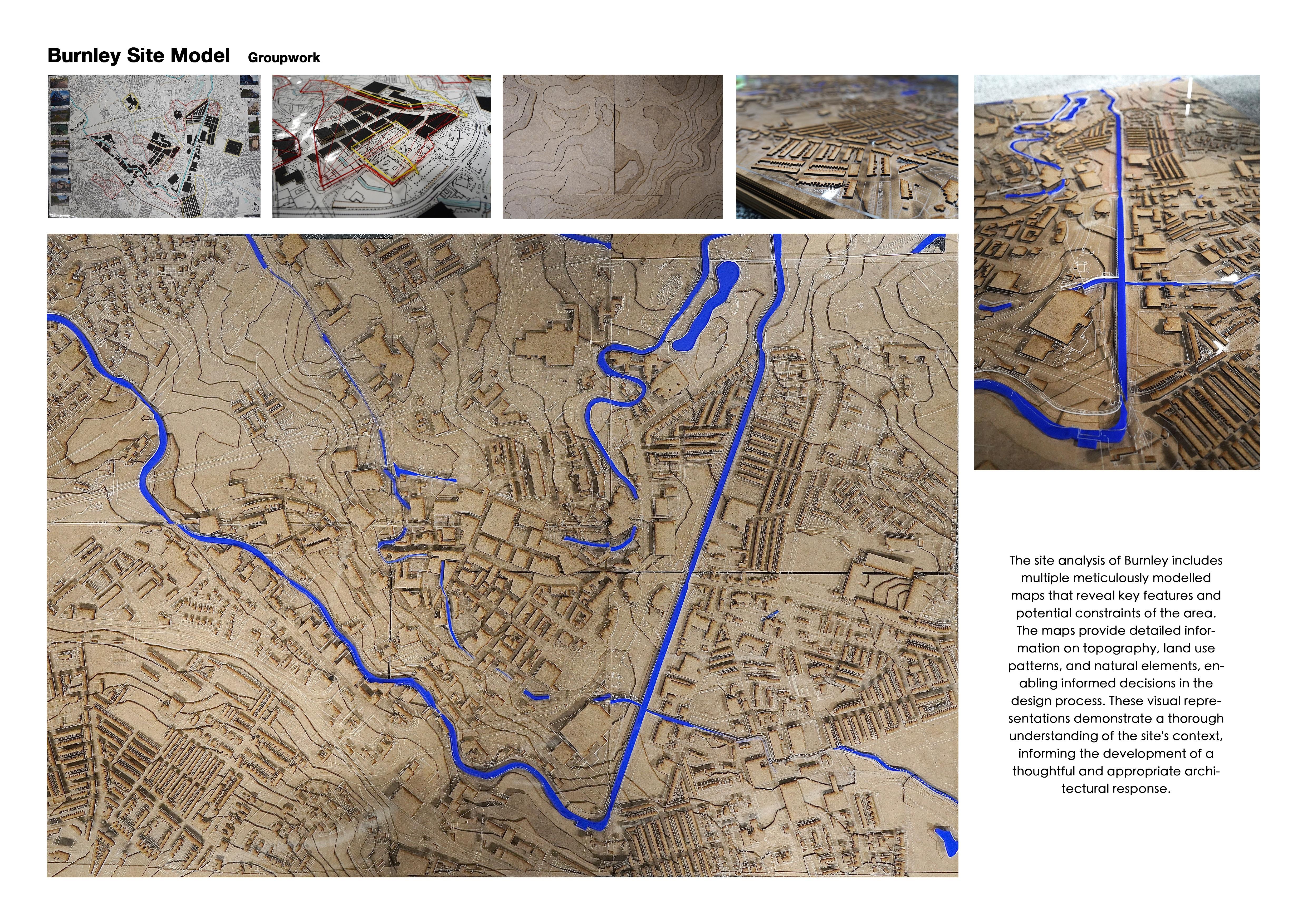
Circulation and Flood
The Baseco Compound has a very good chance of forming a vibrant boundary at the corner. However, there are still many issues with the current condition.
Site Analysis
Concentrated
Concentrated


Urban Strategy
1. Production Area
Improve production level for both fshing and farming.
Create a marine traffc hub to boost local trade Cheap and local materials to make temporary booths.
4. Dock
7. Temporary Activities
2. Electric Power
Make use of both tide and wind power to produce electricity. The boundry could be integrated with public facilities. Reinforced structure to resist typhoon.
5. Flood Protection Barrier
8. Renovated Housing
3. Water Purifcation
equipment to clean water for daily use.
living area for workers.
6. Housing Complex
Working Community
9. Circulation
Production Boundary


Power Station Power Station-Section Farmland & Fish Pond Farmland & Fish Pond-Section Water Purifcation System Water Purifcation System-Section Tidal Energy Fish Pond Farmland Wind Power Flood-Resist Flood-Resist Water Pump Purify
Flood Control


Vertical
Public Gallery Public Gallery-Section
Sunken Plaza Stand Bridge Filter Openning Fish Pond
Boundary Sports Field Sports Field-Section Vertical Farm
Farm-Section
Flood-Resist Flood-Resist Flood-Resist


Community Group Boundary
2 Floor Community Centre
Public Activity Space Public Activity Space-Section Housing Complex Housing Complex-Section
2 Floor Community Centre-Section
Concrete
Container
Shelter
Yard
Steel Panel
Steel Truss Dormitory
Balcony
Flood-Resist
Individual Life Boundary
Container-Temp Housing


Reinforced-Single Family Housing
Container-Temp Shelter


Family2
Reinforced-Multi Family Housing
Temporary
Fish Market Experiencial Shopping
Restaurant
Concrete Panel
Bedroom Balcony Living Room Courtyard Balcony Entrance Family1


0 1 A A B B 1 2 3 4 5 6 7 8 9 10 11 12 13 Fish Pond Water Purifcation System Pier Gallery Basketball Court Skate Park Bridging Berm Power Station Community Centre Water Storage Beach Dormitory Renovated Residence 8 9 12 12 12 13 13 13 13 4 10 11 2 3 4 5 6 7 15 30 60 90 m
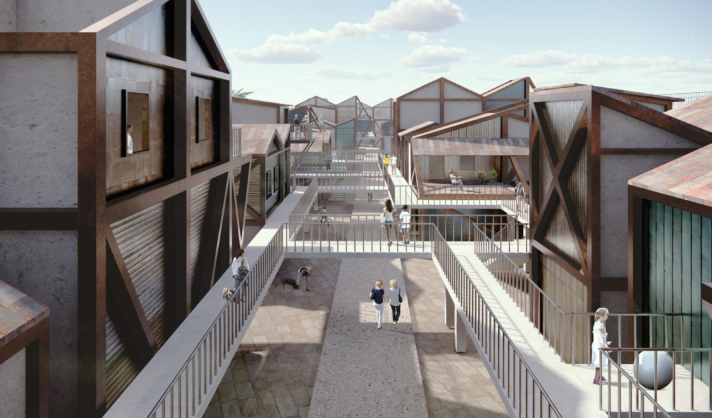
Site Plan The Mixed Boundry project utilises underutilised public space to economically and programmatically beneft the local community.
From Public Facilities to Local Housing From
The public facilities form a vivid boundary that contains various activities. Local residents can enjoy a scenic view and be protected by the height differentiation.
Power
Station to Temporary Activities
Under the power station, there is a lot of public space that could be used for public activities. The containers from decking can be recycled and used as temporary shelter to enhance the public space.
Section A-A
This section reveals the integration of production programs and the spatial relationship from nature to community.


Section B-B
This section highlights the intergration of water purifcation and the market, serves as a multi-layered urban public space for the local community.
From Farmland to Market
The production boundary is closed to the market, which is located beneath the water purifcation infrastructure. It is a dedicated circulation separate from the daily circulation, providing benefts to local production.
From Ground to Elevated Street
The elevated street and steel structure reinforced local housing structure to resist typhoons and foods. Additionally, the public space has been freed and is more accessible to the local residents.
The new boundary of BASECO Compound is an integrated system scales. Natural power, farming, fshing, resistence to natural di boundry of
 Bird's Eye
Eye View
system comprised of urban infrastructure and buildings in varying disasters, and public benefts are well-balanced to revive the of Manila.
Bird's Eye
Eye View
system comprised of urban infrastructure and buildings in varying disasters, and public benefts are well-balanced to revive the of Manila.


Fukushima Nuclear Power Station
Residential Design in the Post-nuclear
Location: Fukushima, Japan
Academic Urban Design Project
Individual Work
The site of this design is located in Fukushima, Japan, where a catastrophic nuclear accident took place on March 11, 2011, following an earthquake and tsunami. The Fukushima Nuclear Power Plant experienced a leak of radioactive pollutants, which led to the release of substantial amounts of water contaminated with radioactive isotopes into the Pacifc Ocean. Professor Michio Aoyama, of the Institute of Environmental Radioactivity, estimated that during the accident, 18,000 terabecquerels (TBq) of radioactive caesium-137 were released into the Pacifc Ocean (GBq) and there were still 30 gigabecquerels (GBq) of caesium-137 fowing into the ocean daily 2 years after the leak in 2013. The accompanying image seeks to depict the fow of nuclear pollutants.
Given the growing number of nuclear power plants in our society, the threat of nuclear pollution continues to rise. This design aims to address the issue of nuclear pollution through urban design. The concept of atmospheric and ocean circulations can be utilised to understand the transport mechanisms of radioactive substances. The spread of contamination depends on the emission amount, the volume of air involved, and the deposition of pollutants through rainfall and snow. Transport and diffusion patterns may change over time.
The design consists of three loops: one for the decontamination of nuclear power plants, one for preventing pollution from reaching fshing grounds, and one for collecting uncontaminated rainwater from neighbouring cities. The urban design aims to make the city's water source self-suffcient by collecting uncontaminated rainwater, while some groundwater and land have become contaminated.

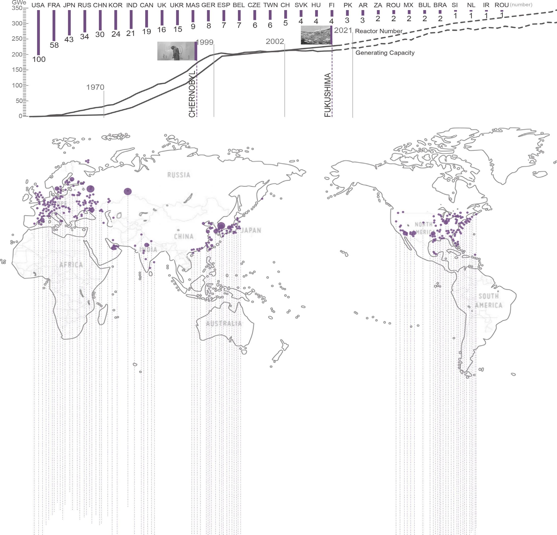
Global Nuclear Power Station Analysis
Behavior Analysis
Methodology

Mapping
Intervention Strategy
One of the loop is a device used for decontaminating nuclear plants. It is situated on the site surrounding the nuclear facility. It has the capability to mitigate pollution issues.
One of the loop, with its primary function as a fshing grounds, connects various marine areas with factories on land in order to prevent pollution from affecting densely populated areas.
One of the loop, with its primary function as a fshing grounds, connects various marine areas with factories on land in order to prevent pollution from affecting densely populated areas.
The rainwater collection loops is located in the city to gather clean, unpolluted water for community use. The site boasts several bio-reserve loops, designed to effciently collect and store rainwater.
One of the loop, with its primary function as a fshing grounds, connects various marine areas with factories on land in order to prevent pollution from affecting densely populated areas.
One of the loop is a device used for decontaminating nuclear plants. It is situated on the site surrounding the nuclear facility. It has the capability to mitigate pollution issues.

N 01050100m
Portable Water Loop
Bioreserved Loop
Pollution Cut-off Loop
Factory
Ocean Current
Typology
Cooling the heated water uesd to generate electricity.
Cooling Water
Nuclear energy is utilised to heat the water, which then drives a steam turbine that generates electricity.
Nuclear Energy
To Purify Pollution
Two fltration systems are employed to purify the cooling water contaminated by nuclear pollution, thereby reducing the overall level of pollution.

Group Level Analysis

Building Analysis Command Pile Up Electricity Transformer Saving Cooling Smoke

Aerial View

N 0 1005001000m Portable Water Site Plan

N 01005001000m Pollution and Bioreserved Site
After being cooled by groundwater and ocean water, nuclear waste water is discharged into frozen soil for further cooling. The electricity generated from this process is used for power generation and facilitate rapid cooling.
It showcases the mitigation of nuclear contamination


Over the sea Factory
Section Perspective
Current Transfer
Permafrost Isolation
contamination and the functionality of nuclear energy facilities.

Heat Emission
Biological adsorption flter plate: let part of nuclear waste water through evaporation, harmful substances through biological adsorption to stay in the loop, clean water through rainwater circulation into the ecosystem.

Perspective Transfer
Cooling Tower
Coast
Generator Cooling

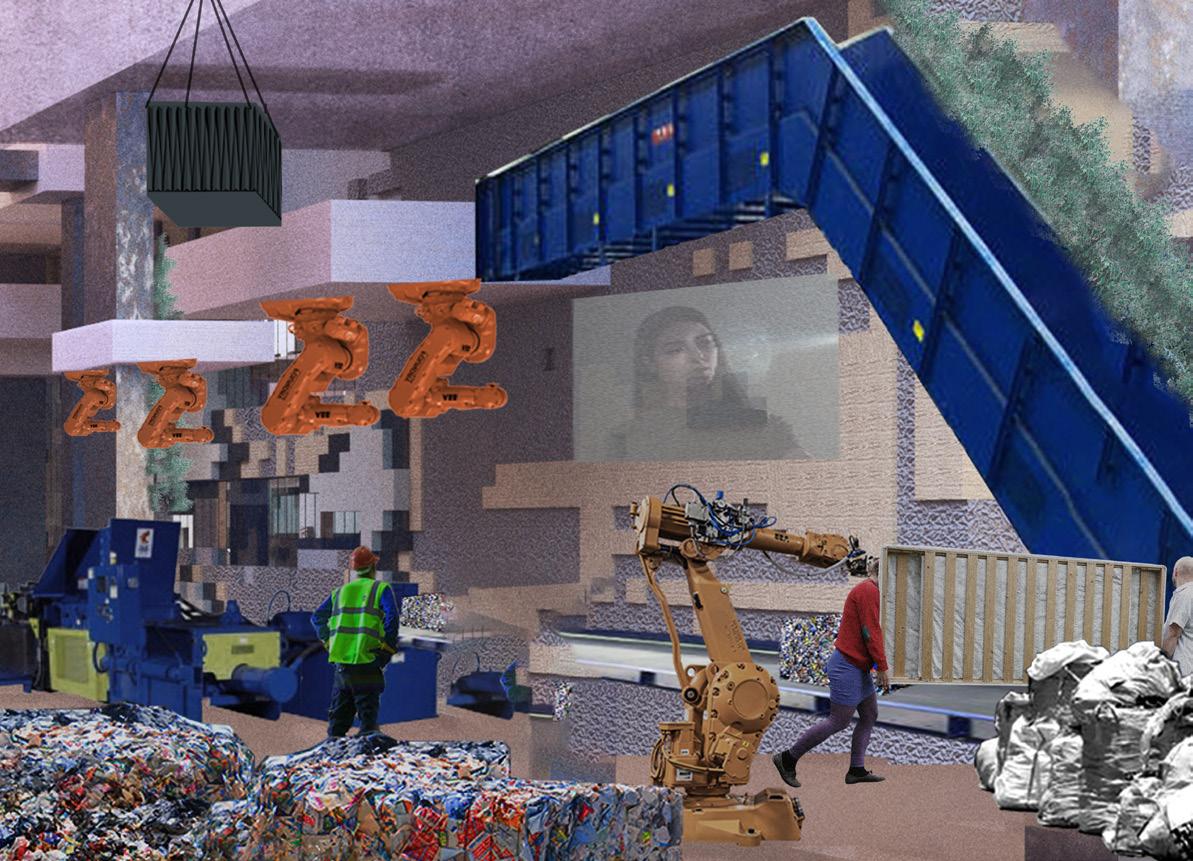
Waste Park
Renewal of waste incineration and landfll park into urban cultural park.
Location: Jiading, Shanghai
Academic Urban Design Project
Individual Work
With the rapid pace of urban development and the enhancement of living conditions, more and more garbage is appearing. Both landfll and garbage incineration are widely recognised as environmentally damaging waste disposal methods, while recycling is often overlooked.
Until the 21st century, in order to protect the environment, numerous environmental protection policies have been introduced. Despite these efforts, a lot of waste continues, and the main obstacle to recycling is the lack of public awareness of recycling. In order to fundamentally solve the emergence of excessive waste generation and the low recycling awareness, this design proposes transforming a waste incineration landfll site into an urban cultural park through the implementation of waste recycling. The design process will utilise machine learning techniques, a novel design approach that combines designs and computing breaking away from the traditional design methods.
The purpose of the design is to convert the polluted landfll into a cultural park in the city addressing the environmental problems caused by landflls and incineration. By showcasing the reuse of a large number of recycled materials in the park, the design hopes to increase public awareness of resource recycling, thereby reducing the occurrence of household waste and increasing the rate of waste recycling.
History and Theory
Architecture is evolving with the development of technology, and numerous distinct styles have emerged over hundreds of years. With the introduction of machine learning, architecture constructed from recycled materials will undergo transformation.

 Wood WastePlastic BagsSolid PlasticTextile Glass Paper Construction Waste
Introduction
Recyclable waste include Wood Waste, Plastic Bags, Solid Plastic, Textile, Glass, Paper, Construction Waste.
Waste on the Earth
The world generates substantial amount of waste every day, which is transported to various countries in the world.

Previously, a signifcant portion of Europe's waste was shipped to China for treatment and decomposition.
Domestic deal with waste produce Per Year
Domestic Material Consumption Per Capita(tones)
Selecting A Site
A Waste Plant in Jiading District, Shanghai

Site Road Railway POI River Residential Area Grassland Legend Site
Methodology
Showing waste disposal and reuse
This design aims to plan and construct a factory + exhibition space to showcase the steps involved in recycling and reusing waste. Wastes are processed and transformed into materials, which are then used to construct the walls of the exhibition, and the wastes can be further recycled and reused to create everyday essentials.
Machine learning design

Construction with recycled materials
This project employs machine learning and intelligent construction techniques. The design of parks and exhibition buildings is generated through machine learning and adjusted in real time using intelligent construction technology.
Raw materials Waste Materials Production Consumption Disposal Recycle Step1Master Plan Factory Plan Facade Step2 Step3
GAN Result of the Site
There have been two large factories on the site retained in the design, and the remaining area has been used to incorporate diverse functions through machine learning. A signifcant quantity of park samples were utlised as a reference, and the fnal layout is generated by interative learning of the samples.


Dataset for Park
Epoch=50
Epoch=150
Epoch=200
Image Site Outline BuildingGreen
AreaParking
Epoch=250 Predicted
SpaceWater Tipping
Gan Result of Plan

Epochs_50 Epochs_50

Dataset for Buildings ExhibitionWorkshopOpen SpaceOffce Storage
Exhibition1 Epochs_50 Epochs_50 Epochs_50
Epochs_50 Epochs_150 Epochs_150 Epochs_150
Epochs_150 Epochs_150 Epochs_150 Epochs_200 Epochs_200 Epochs_200
Epochs_200 Epochs_200 Epochs_200 Epochs_250 Epochs_250 Epochs_250
Predicted
Exhibition5
Epochs_250 Epochs_250 Epochs_250 Epochs_300
Image Epochs_300 Epochs_300 Epochs_300 Epochs_300 Epochs_300 Exhibition2 Exhibition3 Exhibition4
Exhibition6
Masterplan Generation
Predicted image
The 300th generation of machine learning is selected as the fnal result of the masterplan.
Masterplan

The predicted image is segmented into pixels using a grid.

Using different colours to determine the fnal layout.
Add roads into the masterplan.
Legend Road Factory New Building Green Space Water Parking Tipping Area
Split into pixels Allocation
Design road


Facade Generation Dataset for Facade Door Window Wall