118
Good Practices
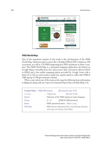
FMIS World Map One of the important outputs of this study is the development of the FMIS World Map, which provides access to the web links (URLs) of PF websites in 198 economies, as well as 176 FMIS supporting key PFM operations in these countries. The FMIS World Map is a geospatial mapping application developed on Google Maps; it benefits from free open-source data conversion software (XLS to KML) and a free public mapping option provided by Google. Icons with a letter (A to D) are used as place marks (on capital cities) to reflect the FMIS & OBD group of 198 government websites. When a user selects one of the icons on the map, the following basic information is displayed, along with any Open Government/Open Data web link (Map 4.1).
Country Name ... FMIS abbreviation [Functional scope: F/T] Location
: Capital city
[Income level]
System
: Full name of the FMIS solution in native language
Group
: A - D
Status
: FMIS operational status  [Since: year]
Web links
: F MIS, Finance Ministry/Dept, Central Bank, Statistics, and Open Gov/Open Data URLs.
[FMIS & OBD practices]
Financial Management Information Systems and Open Budget Data http://dx.doi.org/10.1596/978-1-4648-0083-2