Cycling and Walking: Preserving a Heritage, Regaining Lost Ground
251
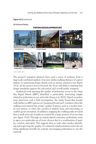
Figure 10.3 (continued) (b) Entrance Design
Source: Urbis 2011.
The project’s transport planners have used a series of analyses, from a large scale catchment analysis of an area within walking distance of a given station, to optimizing design details such as station entrances (see figure 10.3). As the project moves forward, the focus will shift to ensuring that design standards support the rail system and overall public transport. Analytical work assessing the quality of pedestrian access to the Jinan Bus Rapid Transit (BRT) identified a particularly interesting insight related to pedestrian access networks (Jiang et al. 2012). Based on pedestrian interviews and a field investigation, the study found that people walk farther to BRT stations on “integrated-boulevard” corridors when the walking environment has certain “quality” features, such as a median transit way station, or when the corridor is shaded, busy, and interesting, or enables good orientation. In addition, mapping the walking paths revealed that a small network of paths accounted for a large portion of access trips (see figure 10.4). Through an unarticulated consensus, pedestrians seem to agree on a particular set of route choices due to a combination of quality, comfort, and safety. This suggests that, as with other modes, identifying and improving the quality of a relatively small pedestrian network can bring significant benefits by actively encouraging pedestrians to use the network.