

Transforming cameras into autonomous robotic teammates

Who we are Our vision Our mission
A submariner veteranfounded team of police, ex-military, and leading UK experts in edge-based video analytics for Defence and Security.
To fully automate the cameras that protect us.
To pioneer vision automation for a more peaceful and prosperous world.

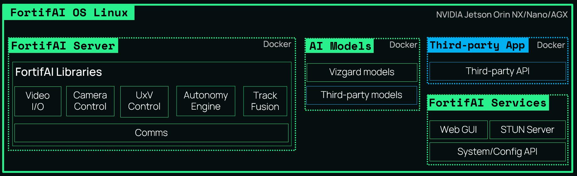
FortifAI
FortifAI is state-of-the-art visual autonomy software that enhances existing systems with time-critical visual intelligence and precise camera and UxV platform control. Our revolutionary, platform-agnostic flagship product operates on low-power edge processors and has been proven in the field on UAVs, UGVs, USVs, C-UAS systems, long-range surveillance cameras, and even an uncrewed submarine.
Rapid integration with systems


Time-critical visual and thermal video alerts
Person, crowd, vehicle behaviour risk analysis

Multi-camera and UxV automation
Hot-swappable models for land, air and sea

Open architecture to run your own models


1. Unmanned System Automation
Installed on board or near the operator, FortifAI identifies threats, automates patrols, and enables GNSS-denied air and sea-borne terminal guidance.
3. Counter-drone
As part of a multi-sensor C-UAS solution, FortifAI reduces false alarms by steering cameras to verify radar and RF tracks. It also provides 360° sky scans to detect non-transmitting aerial objects like gliders or unauthorised drones.


2. Long-range surveillance
FortifAI coordinates multiple Pan/ Tilt/Zoom cameras to scan areas for armed threats, acting as the ‘camera brain’ in long-range coastal or border surveillance systems.
4. Public safety
Deployed in a GPU server rack, FortifAI empowers CCTV operators to detect challenging incidents that might otherwise be missed, including knife suspects, suicides, violence against women, and vehicle-as-a-weapon scenarios.
How it works

AI Object types
1: Person, vehicle, drone, bird, plane, face, heli, boat
2: Person, car, large vehicle, bike, number plate, weapon, face
3: Drone, plane, helicopter, bird, small aerial object
4: Various maritime
5: Any third-party YOLO detction model (V4, V7 and V8 currently supported)
Interoperability
Mavlink
SAPIENT
ONVIF Profile S
Next Vision
NMEA 0183
HereLink
Parrot Anafi USA
RTSP
WebRTC
MPEG-TS
DJI
ATAK
Platform control and status
Autonomous node in C2 network
Camera control and status
Camera control
AIS track and GPS inputs
Processed video output
Control and status
Video input and output
Browser video output
Input and output
Dock 1 & 2 (Cloud API)
Cursor on Target track output

Find the unseen
VizEdge
VizEdge equips military and security personnel with a rugged, wearable, low-SWAP computer that processes real-time sensor data at the tactical edge.
High-performance AI
Up to 100 TOPS of AI compute for instant analytics and decision-making. Can be used with FortifAI or third-party software such as a TAK server.
On-device video processing
Processes high-bandwidth video and sensor data in the field, reducing latency, eliminating cloud dependence, and increasing security.
Rugged and wearable design
IP67-rated, it can be worn (MOLLE compatible) or mounted on a vehicle or unmanned platform.

AI Performance Nvidia Orin NX 16GB (100 TOPS), Nano (40 TOPS)
Power 12-28vDC NX 30W Peak, Nano 15W
Storage 128GB to 2 TB NVMe SSD
VizEdge I/O
Cable Fischer Minimax IP68 connector breaking out to:
1 x GbE RJ45 Female 0.3m
1 x USB C 2.0 Right-angled to EUD 0.75m
1 x USB A 2.0 Recepticle 0.3m
1 x Nett Warrior male (power in from battery) 0.5m
Dimensions 225mm x 120mm x 52mm ~600g
Environmental IP67 -20 to +55C ambient
Compatibility Parrot Anafi USA (Direct WiFi) Nett Warrior (Power and USB 2.0) MOLLE (Webbing mounting)
Misc Processor assembly also available without enclosure (~125g)

Multidomain autonomy
V-GroundControl
Our enhanced version of the popular QGroundControl drone software, customised for Defence and Security applications with advanced C2 functionality.
Standard Features:
• Multiple layouts, including 3 video streams and 1 map.
• Parrot Anafi USA control.
• Drone view displayed on the map. With FortifAI Integration:
• Dynamic Automatic Target Recognition with filtering.
• Optical detections plotted on map with thumbnails.
• Automated gimbal steering, drone following, and terminal guidance.
• Automated control of ground-based Pan/Tilt/Zoom cameras.
• Mid-mission detection model switching


Never Lose Sight
