TECH & TOOLS
SCANNING THE CONSTRUCTIVE IMPACT OF LIDAR By TREVOR HOGG
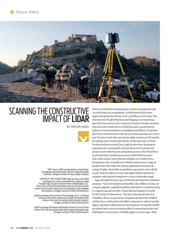
TOP: Since LiDAR can generate so much data, managing and processing it can be computationally intensive. (Image courtesy of Clear Angle Studios) OPPOSITE TOP TO BOTTOM: High-accuracy 3D LiDAR scanning of an iconic monumental sculpture called “Awakening” located at Hains Point in Washington, D.C. The results of this documentation process can be used for various conservation processes or to reproduce the complex 3D sculpture. (Image courtesy of Direct Dimensions) LiDAR scanning of the inside of the fuselage of a C-5 military transport aircraft to create an accurate 3D model of the interior structure for loading optimization analysis. (Image courtesy of Direct Dimensions) LiDAR scanning the historic Bethesda Terrace in Central Park in New York City for preservation and conservation planning. (Image courtesy of Direct Dimensions)
There is a belief that technology has not gone mainstream until it can be found on a smartphone. LiDAR achieved this when Apple introduced the iPhone 12 Pro and iPhone 12 Pro Max. The introduction of Light Detection and Ranging is not surprising given that the camera is the cornerstone feature driving consumer interest in the mobile device. LiDAR has had a transformative impact on various industries, including visual effects. Companies like Direct Dimensions provide advanced 3D scanning and convert raw 3D ‘point cloud’ data into precise high-resolution CAD models for military and commercial vehicles. At the same time, Virtual Production Partners and Clear Angle Studios have developed a reputation for scanning film and television sets, locations and props to assist with the post-production process. The Third Floor has elevated the visualization process with LiDAR to ensure that costly creative and technical mistakes are avoided. Leica Geosystems, who manufactures LiDAR scanners, has a range of product lines that reflect the diverse applications for the technology. Finally, clients like visual effects supervisors view LiDAR as part of their toolkit to ensure that digital effects seamlessly integrate with practical elements to create a believable image. Approximately 25 years ago, LiDAR was developed for industrial purposes. “Gas and oil plants and facilities, like offshore oil rigs, are complex, gigantic, magnificent places, and they’re constantly doing re-engineering and retrofits,” states Michael Raphael, Founder & CEO of Direct Dimensions. “The idea of having 3D data is so valuable to them. As gas and oil companies got their first whiff of LiDAR, they would underwrite R&D companies to make it smaller, lighter and faster, which drove its development. Eventually, LiDAR got picked up by surveyors responsible for measuring terrain and buildings for construction. Probably eight or 10 years ago, a little
46 • VFXVOICE.COM SUMMER 2025
PG 46-51 LIDAR.indd 46
4/25/25 1:56 PM