Sandy Cape Sandy Cape Lighthouse
Fraser Island
Diray
Rooney Point
Ngkala Rocks
Whale Bay
Ocean Lake
Orchid Beach Waddy Po Point
Wathumba Creek
Champagne Pools
Indian an Head
Towoi Creek
GREAT SANDY NATIONAL PARK
Awinya Creek
Corroboree Beach
Bowarrady warrady Creek ek
Great Sandy Marine Park
Wungul Sandblow Lake Bowarrady ady dy
D db Dundubara Cathedral Beach
Woralie ie Creek
Coongul Creek
Boomerangg Lakes La
Moon Point
Red Canyon
Lake Allom llom m
K’gari
The Pi PPinnacles nn
Lake Coomboo
Knifeblade Sandblow Knife Maheno Wrec Wreck
Yidney Scrub
HERVEY BAY
Elii CCreekk
Lake Garawongera
Kirrar Sandblow
Kingfisher Bay Lakee McKenzie
River Heads
Happy Valley Yidney Ro Rocks Great Walk
Poyungan Rocks
Wanggoolba W Wa Wan a Creek
LLake Wabby
CCentral t l Station Stt ttii Lake Birrabeen Lake B Benaroon
1
Eurong QWPS Information Centre
EEurong
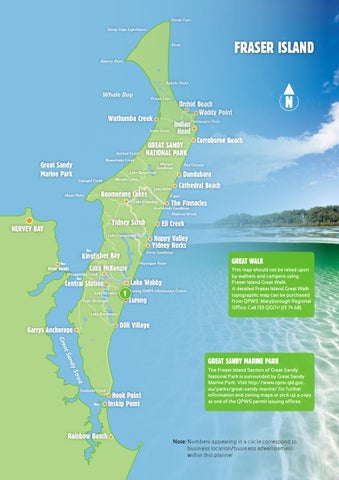
This map should not be relied upon by walkers and campers using Fraser Island Great Walk. A detailed Fraser Island Great Walk topographic map can be purchased from QPWS. Maryborough Regional Office: Call 133 QGOV (13 74 68)
Lake Boomanjin
Dilli Village
Garrys Anchorage a at S
Gre ndy
Great Sandy Marine park
t
ai Str Coolooloi Creek
Rainbow Beach
Hook Point Inskip Point
The Fraser Island Section of Great Sandy National Park is surrounded by Great Sandy Marine Park. Visit http://www.nprsr.qld.gov. au/parks/great-sandy-marine/ for further information and zoning maps or pick up a copy at one of the QPWS permit issuing offices.
Note: N umbers appearing in a circle correspond to business location/business advertisement within this planner For more information visitfrasercoast.com
7