7 minute read
PREPARING FOR EXTREME STORMS

Sarah Sell and Dyllan Furness
Scientists at USF are a valuable resource when it comes to forecasting hurricanes and identifying climate risks in vulnerable coastal communities. Whether it’s a deep-diving ocean glider that captures key data about a storm’s intensity or a community-based web application that predicts flooding, their research and use of advanced technology is garnering attention nationwide.
Protecting Vulnerable Neighborhoods By Crowdsourcing Data
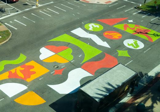
A $1.5 million National Science Foundation grant will allow researchers to develop a web-based application that gathers crowdsourced data in coastal communities to identify flooding risks and inform policy. Led by USF St. Petersburg GIS and Remote Sensing Professor Barnali Dixon, the research team will create the CRIS-HAZARD app.
The app will combine volunteered geographic information and community crowdsourced data such as photos and videos with near real-time data on flooding. Using dynamic modeling and mapping tools, including artificial intelligence, the app will identify and extract estimated water elevation for near real-time flood models that can inform emergency managers and policymakers.
“To develop a custom policy that meets the needs of each unique community, you need to know the data,” said Dixon, who is also executive director of USF’s Initiative on Coastal Adaptation and Resilience (iCAR). “The power of this system is that it allows us to see the needs of these communities on a very granular scale, so you can then put policies in place.”
The new app, which will provide an interactive user experience, is based off the existing Community Resiliency Information System (CRIS), a website created in 2020 by iCAR.
The CRIS platform leverages crowdsourced data to identify climate-related vulnerabilities in local communities. Residents can input information related to issues such as flooding and power outages. The information can be used by policymakers and neighborhood leaders to make decisions about policy and resource allocation. The data also allows emergency managers to identify areas with concentrations of people who need transportation assistance or are reliant on power for medical needs.
Dixon has been working with community leaders in south St. Petersburg neighborhoods for several years, where residents have successfully used the system to prepare for extreme storm events. Through the CRIS website, participants can view maps and see their risk of storm surge and sea level rise. They can also share their own information and suggest ways to improve the system.
“We have used the application at all our community town halls,” said Erica Hall, executive director of the Florida Food Policy Council. “As a community leader and liaison, this will help communities tremendously to understand the connection between sea level rise, climate change, extreme heat and coastal flooding. Some coastally vulnerable neighborhoods also show food insecurity, health disparities and environmental justice concerns. Having CRIS map those concerns tells a story that will allow the community to understand.”
After Hurricane Ian in 2022, Dixon and her team used GIS to map areas identified as coastally vulnerable communities that experienced inequitable access to disaster relief and assistance but also showed that the neighborhoods were food insecure. Some of them were without power and food for much longer than they should have been.
As principal investigator, Dixon is developing the new application alongside co-principal investigators Yi Qiang from USF and two others from Georgia Tech, Subhrajit Guhathakurta from the College of Design and Peng Chen from the College of Computing.
The research team will continue to work with community partners in St. Petersburg’s Childs Park and expand to other coastally vulnerable areas of Pinellas County, including Shore Acres, West and East Lealman and Bahama Shores.
The CRIS-HAZARD app will be developed by researchers using community and emergency management input over the next three years, and then can be used by both local neighborhoods and communities nationwide.
Gliders Capture Ocean Data For Hurricane Forecasting
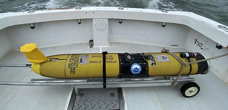
Scientists at USF are also using advanced technology to help forecasters predict the intensity of a storm in the ocean. Some 150 miles off the coast of Florida in the Gulf of Mexico, an uncrewed yellow submersible dives deep below the sea surface. Its mission: collect data for hurricane forecasting.
The submersible, which began its three-month deployment in July, is part of an eight-vessel research fleet operated by the College of Marine Science (CMS) Ocean Technology Group.
CMS will receive around $200,000 over two years from the National Oceanic and Atmospheric Administration (NOAA) to monitor ocean conditions in the eastern Gulf of Mexico and along the South Atlantic Bight, which stretches from North Carolina to the Florida Keys.
Semiautonomous vessels operated by CMS and other NOAA partners will capture key data to help the federal agency improve the representation of the ocean and atmosphere in hurricane forecast models. CMS gliders collected these data in the past, but this is the first year the team has deployed submersibles specifically for this purpose.
Fresh water from nearby rivers can have an influence on the ocean’s ability to mix up colder, deeper waters that might help reduce a storm’s strength. -Kathy Bailey
Called gliders for the graceful way they move through water, each vessel can travel hundreds of miles on months-long missions and send data back to shore via satellite. Since gliders have no people on board, they have greater endurance, fewer risks and lower costs than crewed vessels.
“Gliders are one of the most cost-effective and reliable ways to gather subsurface data,” said Chad Lembke, a project engineer and research faculty member in the CMS Ocean Technology Group. “They can cover many miles from the surface to the seafloor with little input needed from human operators.”
This ability to traverse the water column makes gliders valuable for hurricane research and monitoring. Hurricanes require ocean temperatures of 79 degrees Fahrenheit or higher to form and sustain their strength. Warm waters provide energy to turn tropical storm systems into powerful hurricanes, and the deeper the warm water reaches into the water column, the more fuel at the storm’s disposal.
“Scientists have realized that water ‘at depth’ is an important factor in hurricane intensification,” said Lembke. “By using gliders to measure the depth of warm water, researchers can better quantify the total heat content available to storms, which helps NOAA’s hurricane forecasters better understand whether a storm will increase in strength as it approaches landfall.”
In addition to temperature, gliders monitor ocean salinity, another key metric that helps experts predict hurricane intensity. Research has shown that areas of low salinity can cause storms to intensify and trigger rapid intensification, a dangerous phenomenon during which a storm’s top wind speed increases by 35 mph in a single day. Hurricane Ian went through two bursts of rapid intensification before it made landfall in southwest Florida last year.
“Fresh water from nearby rivers can have an influence on the ocean’s ability to mix up colder, deeper waters that might help reduce a storm’s strength,” said Kathy Bailey, a program manager for NOAA’s U.S. Integrated Ocean Observing System, which leads the glider effort. “We are able to ‘see’ these features in glider measurements of temperature and salinity. We need accurate ocean and atmosphere models to forecast hurricane intensity — these measurements are used to help keep the ocean models on track, so we have the best chance of producing an accurate hurricane intensity forecast with the best ocean information possible.”
Gliders are good for monitoring more than hurricanes. They’re packed with a suite of onboard sensors that assist with assessments of water quality, fisheries management and ocean circulation models. Lembke compares gliders to pickup trucks for the way his team can load them up with instruments.
Since 2020, as part of the College’s Center for Red Tide Tracking and Forecasting effort, gliders have been focused on helping scientists monitor red tide, which has had devastating impacts on marine life and economies along Florida’s Gulf Coast. Data about physical and chemical properties such as temperature, salinity and dissolved oxygen has been used to refine computer models that predict red tide development.
NOAA’s funding is well-timed; 2023 proved to be an active hurricane season driven in part by above-average temperatures in the Atlantic Ocean and Caribbean Sea.
The new funding, which supports one deployment in the Gulf of Mexico and two in the Atlantic Ocean, allows CMS to focus its gliders on gathering data to improve hurricane forecasting and enable communities to better prepare for storms.