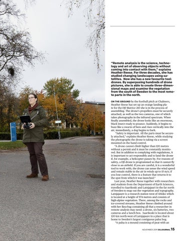
“Remote analysis is the science, technology and art of observing objects without coming into contact with them,” explains Heather Reese. For three decades, she has studied changing landscapes using satellites. Now she has a new favourite tool: drones. By superposing hundreds of drone pictures, she is able to create three-dimensional maps and examine the vegetation from the south of Sweden to the most remote parts in the north. ON THE GROUND by the football pitch at Chalmers, Heather Reese has set up an orange landing plate for the DJI Matrice 210 she is in the process of assembling. The drone’s propellers must be securely attached, as well as the two cameras, one of which takes photographs in the infrared spectrum. When finally assembled, the drone looks like an enormous, black insect ready to pounce. Suddenly, it begins to buzz like a swarm of bees and rises vertically into the air; immediately, a dog begins to bark. “Safety is important. All the parts must be securely attached,” explains Heather Reese, while studying the photographs the drone is taking via a screen mounted on the hand control. “A drone cannot climb higher than 120 metres without a permit and it must be constantly monitored. But in addition to complying with regulations, it is important to act responsibly and to land the drone if, for example, a helicopter passes by. For reasons of safety, a DJI drone is programmed so that it cannot fly close to an airfield. If you are careful, it is a wonderful tool to work with; the drone can sense the wind speed and remain stable in the air in winds up to 15 m/s; if you lose control, there is a feature that returns it to the spot from which it was launched.” Last year, Heather Reese together with researchers and students from the Department of Earth Sciences, travelled to Saarikoski and Latnjajauri in the far north of Sweden to map out the vegetation and topography. Latnjajaure is a research station west of Abisko which is located at a height of 974 metres and consists of high-alpine vegetation. There, among the rocks and ice-covered streams, Heather Reese climbed around with her Ikea-bag containing all that a researcher in remote analysis may need: a drone, six batteries, two cameras and a lunch-box. Saarikoski is located about 120 km north-west of Latnjajaure in a place that is home to Sweden’s largest contiguous palsa bog. “A palsa is a mound consisting of peat with an NOVEMBER 2019 GUJOURNAL
15