
5 minute read
The Islands

from Quiz on Rivers
by Umeopedia

peninsular plateau. These are highly eroded hills and are found as broken hills. They extend from Gujarat to Delhi in a southwest-northeast direction.
The Indian Desert
Advertisement
The Indian desest lies towards the western margins of the Aravali Hills. It is an undulating sandy plain covered with sand dunes. This region receives very low rainfall below 150 mm per year. It has arid climate with low vegetation cover. Streams appear during the rainy season. Soon after they disappear into the sand as they do not have enough water to reach the sea. Luni is the only large river in this region.
Figure 2.9 : The Indian Desert
Barchans (crescent shaped dunes) cover larger areas but longitudinal dunes become more prominent near the Indo-Pakistan boundary. If you visit Jaisalmer, you may go to see a group of barchans.
The Coastal Plains
The Peninsular plateau is flanked by stretch of narrow coastal strips, running along the Arabian Sea on the west and the Bay of Bengal on the east. The western coast, sandwiched between the Western Ghats and the Arabian Sea, is a narrow plain. It consists of three sections. The northern part of the coast is called the Konkan (Mumbai – Goa), the central stretch is called the Kannad Plain while the southern stretch is referred to as the Malabar coast.
14
Figure 2.10 : The Coastal Plains
The plains along the Bay of Bengal are wide and level. In the northern part, it is referred to as the Northern Circar, while the southern part is known as the Coromandel Coast. Large rivers such as the Mahanadi, the Godavari, the Krishna and the Kaveri have formed extensive delta on this coast. Lake Chilika is an important feature along the eastern coast.

The Chilika Lake is the largest salt water lake in India. It lies in the state of Orissa, to the south of the Mahanadi delta.
The Islands
You have already seen that India has a vast main land. Besides this, the country has also two groups of islands. Can you identify these island groups?
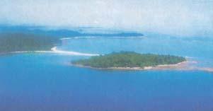
Figure 2.11 : An Island
Locate the Lakshadweep Islands group lying close to the Malabar coast of Kerala. This group of islands is composed of small coral isalnds. Earlier they were known as Laccadive, Minicoy and Amindive. In 1973 these were
CONTEMPORARY INDIA
named as Lakshadweep. It covers small area of 32 sq km. Kavaratti island is the administrative headquarters of Lakshadweep. This island group has great diversity of flora and fauna. The Pitti island, which is uninhabited, has a bird sanctuary.
Corals
Coral polyps are short-lived microscopic organisms, which live in colonies. They flourish in shallow, mud free and warm waters. They secrete calcium carbonate. The coral secretion and their skeletons from coral deposits in the form of reefs:. they are mainly of three kinds: barrier reef. fringing reef and atolls. The Great Barrier Reef of Australia is a good example of the first kind of coral reefs. Atolls are circular or horse shoe shaped coral reefs.

Now you see the elongated chain of islands located in the Bay of Bengal extending from north to south. These are Andaman and Nicobar islands. They are bigger in size and are more numerous and scattered. The entire group of islands is divided into two broad categories – The Andaman in the north and the Nicobar in the south. It is believed that these islands are an elevated portion of submarine mountains. These island groups are of great starategic importance for the country. There is great diversity of flora and fauna in this group of islands too. These islands lie close to equator and experience equatorial climate and has thick forest cover.
India’s only active volcano is found on Barren island in Andaman and Nicobar group of Islands.
A detailed account of the different physiographic units highlights the unique features of each region. It would, however, be clear that each region complements the other and makes the country richer in its natural resources. The mountains are the major sources of water and forest wealth. The northern plains are the granaries of the country. They provide the base for early civilisations. The plateau is a storehouse of minerals, which has played a crucial role in the industrialisation of the country. The coastal region and island groups provide sites for fishing and port activities. Thus, the diverse physical features of the land have immense future possibilities of development.
EXERCISE
1. Choose the right answer from the four alternatives given below. (i) A landmass bounded by sea on three sides is referred to as (a) Coast (c) Peninsula (b) Island (d) none of the above (ii) Mountain ranges in the eastern part of India forming its boundary with Myanmar are collectively called as (a) Himachal (c) Purvachal (b) Uttarakhand (d) none of the above (iii) The western coastal strip, south of Goa is referred to as (a) Coromandel (c) Kannad (b) Konkan (d) Northern Circar (iv) The highest peak in the Eastern Ghats is (a) Anai Mudi (c) Mahendragiri (b) Kanchenjunga (d) Khasi 2 Answer the following questions briefly. (i) What are tectonic plates? (ii) Which continents of today were part of the Gondwana land?
PHYSICAL FEATURES OF INDIA 15
(iii) What is the bhabar? (iv) Name the three major divisions of the Himalayas from north to south. (v) Which plateau lies between the Aravali and the Vindhyan ranges? (vi) Name the island group of India having coral origin. 3. Distinguish between (i) Converging and diverging tectonic plates (ii) Bhangar and Khadar (iii) Western Ghats and Eastern Ghats 4. Describe how the Himalayas were formed. 5. Which are the major physiographic divisions of India? Contrast the relief of the
Himalayan region with that of the Peninsular plateau. 6. Give an account of the Northern Plains of India. 7. Write short notes on the following. (i) The Indian Desert (ii) The Central Highlands (iii) The Island groups of India
M AP SKILLS
On an outline map of India show the following. (i) Mountain and hill ranges – the Karakoram, the Zaskar, the Patkai Bum, the
Jaintia, the Vindhya range, the Aravali, and the Cardamom hills. (ii) Peaks – K2, Kanchenjunga, Nanga Parbat and the Anai Mudi. (iii) Plateaus, Chotanagpur and Malwa (iv) The Indian Desert, Western Ghats, Lakshadweep Islands
P ROJECT/ACTIVITY
Locate the peaks, passes, ranges, plateaus, hills, and duns hidden in the puzzle. Try to find where these features are located. You may start your search horizontally, vertically or diagonally.


