7 minute read

Using Geologic Maps to Inform Hazard Investigations

Next Article
Projects

Projects

SINKHOLE AND KARST SUSCEPTIBILITY MAPPING IN NORTH-CENTRAL IOWA:

Using Geologic Maps to Inform Hazard Investigations

Advertisement

by Stephanie Tassier-Surine, Phil Kerr, Ryan Clark, and Jason Vogelgesang

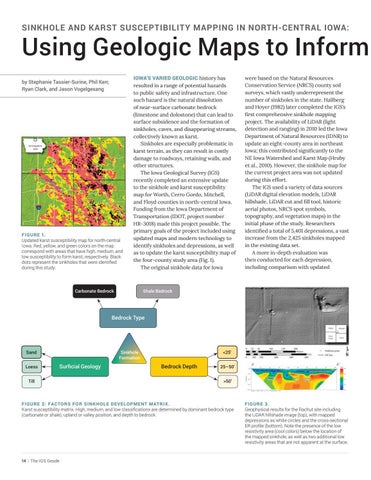
FIGURE 1. Updated karst susceptibility map for north-central Iowa. Red, yellow, and green colors on the map correspond with areas that have high, medium, and low susceptibility to form karst, respectively. Black dots represent the sinkholes that were identified during this study. IOWA’S VARIED GEOLOGIC history has resulted in a range of potential hazards to public safety and infrastructure. One such hazard is the natural dissolution of near-surface carbonate bedrock (limestone and dolostone) that can lead to surface subsidence and the formation of sinkholes, caves, and disappearing streams, collectively known as karst.

Sinkholes are especially problematic in karst terrain, as they can result in costly damage to roadways, retaining walls, and other structures.

The Iowa Geological Survey (IGS) recently completed an extensive update to the sinkhole and karst susceptibility map for Worth, Cerro Gordo, Mitchell, and Floyd counties in north-central Iowa. Funding from the Iowa Department of Transportation (IDOT, project number HR-3018) made this project possible. The primary goals of the project included using updated maps and modern technology to identify sinkholes and depressions, as well as to update the karst susceptibility map of the four-county study area (Fig. 1).

The original sinkhole data for Iowa were based on the Natural Resources Conservation Service (NRCS) county soil surveys, which vastly underrepresent the number of sinkholes in the state. Hallberg and Hoyer (1982) later completed the IGS’s first comprehensive sinkhole mapping project. The availability of LiDAR (light detection and ranging) in 2010 led the Iowa Department of Natural Resources (IDNR) to update an eight-county area in northeast Iowa; this contributed significantly to the NE Iowa Watershed and Karst Map (Hruby et al., 2010). However, the sinkhole map for the current project area was not updated during this effort.

The IGS used a variety of data sources (LiDAR digital elevation models, LiDAR hillshade, LiDAR cut and fill tool, historic aerial photos, NRCS spot symbols, topography, and vegetation maps) in the initial phase of the study. Researchers identified a total of 5,401 depressions, a vast increase from the 2,425 sinkholes mapped in the existing data set.

A more in-depth evaluation was then conducted for each depression, including comparison with updated

Carbonate Bedrock Shale Bedrock

Bedrock Type

Sand

Loess

Till Surficial Geology

Sinkhole Formation

Bedrock Depth

<25'

25–50’

>50’

FIGURE 2: FACTORS FOR SINKHOLE DEVELOPMENT MATRIX. Karst susceptibility matrix. High, medium, and low classifications are determined by dominant bedrock type (carbonate or shale), upland or valley position, and depth to bedrock. FIGURE 3. Geophysical results for the Rachut site including the LiDAR hillshade image (top), with mapped depressions as white circles and the cross-sectional ER profile (bottom). Note the presence of the low resistivity area (cool colors) below the location of the mapped sinkhole, as well as two additional low resistivity areas that are not apparent at the surface.

Using Geologic Maps to Inform Hazard Investigations

geologic maps. County-scale surficial and bedrock geologic maps produced by the IGS between 2012 and 2018 provided an improved understanding of the lithologic character and distribution of the geologic units. These recent bedrock geologic maps subdivided the bedrock units at the formation level, rather than at the group level as provided by the Bedrock Geologic Map of Iowa (Witzke et al., 2010). The Lime Creek Formation was also remapped at the member level as part of the current project.

The IGS also evaluated surficial geologic maps that were not available for this area in previous karst studies; this allowed researchers to determine the level of influence surficial materials may have on sinkhole formation. Surficial geology did not appear to have a significant impact in upland areas, likely because of glacial till acting as an aquiclude (a geologic unit that inhibits the flow of water). However, the surficial geology is thought to aid in sinkhole formation in the valleys, where sand and gravel are present and do not restrict water infiltration to the bedrock surface. Here, the sand and gravel may also mask the surface expression of sinkholes, making them harder to identify.

Records from new wells drilled since the geologic maps were produced were also incorporated, and passive seismic geophysical field data were collected to confirm the bedrock depth for areas with limited information.

After all data were assessed, a total of 4,175 of the depressions initially identified were interpreted as sinkholes. Anthropogenic features and depressions related to surficial geology (e.g., sand dunes) were the most common reasons that points were not considered sinkholes.

The IGS assessed karst susceptibility by categorizing each location based on bedrock type, surficial geology, and the depth to bedrock. This assessment established a matrix assigning each combination as having a high, medium, or low potential to form karst (Fig. 2). Bedrock was considered to have a high karst potential if it was composed predominantly of carbonate and was less than 25 feet below the land surface; medium or low potential was assigned when shale was the initial bedrock lithology and/or if bedrock was greater than 25 feet deep. Surficial units were grouped into upland and valley settings. Upland settings are more likely to be mantled with relatively impermeable till deposits and therefore are less likely to form karst. Data from valley settings indicate that sand and gravel is present at the surface; however, there was not always sufficient information to determine if a less permeable till unit was present between the sand and gravel and the bedrock surface. Therefore, all valley units that were less than 50 feet to bedrock were considered to have a high karst potential. Statistical validation of the karst potential groupings showed that 85 percent of the sinkholes occurred in areas where the bedrock surface was within 25 feet of the land surface. The most common bedrock units hosting sinkholes were the Devonian Lithograph City Formation and Cretaceous outliers.

The field assessment included electrical resistivity geophysical surveying (ER) at three locations in the study area to investigate the subsurface character of sinkholes and sinkhole complexes. Each location was in an area where bedrock was less than 25 feet from the surface. Two were in upland settings with glacial till overlying carbonate bedrock. Of the two sites in upland settings, one was actively being farmed (Rachut site) and the other was grassland that had not been farmed in many years (Mitchell County Conservation Board site). The third site (Falk site) had sand and gravel overlying shallow carbonate bedrock and was actively farmed. In all cases, a low resistivity zone was identified in the vicinity of a mapped sinkhole. At the Mitchell County Conservation Board site, an area of low resistivity was identified between sinkholes and beneath what appeared to be competent bedrock. This interesting discovery suggests that sinkholes may be connected at depth, even if surface expression is not apparent. Results from the Rachut site in Fig. 3 show the ability to image both known and unknown subsurface features.

The IGS more than doubled the number of mapped sinkholes in Worth, Cerro Gordo, Mitchell, and Floyd counties and made substantial improvements to the karst susceptibility map for the study area. The study identified two primary factors that affect the formation of sinkholes: the depth to the bedrock surface and bedrock lithology (carbonate versus shale). The bedrock geologic map units dominated by carbonate lithologies correlated very closely with the areas that formed sinkholes, and most sinkholes occur in areas where the bedrock surface is less than 25 feet below the land surface. This study illustrates the need for more detailed bedrock elevation and geologic maps in karst-prone areas of Iowa. An assessment of the surficial geologic mapping units helped determine if depressions were sinkholes, demonstrating that the surficial geology is an effective screening tool for sinkhole evaluation.

Karst has long been known to have a significant impact on infrastructure in areas of Iowa with certain geologic conditions. A better understanding of the sinkhole distribution and likelihood could increase safety and avoid costly repairs.

For bedrock and surficial geologic maps, see the IGS publications website: https://tinyurl.com/djnuf8.wm.

REFERENCES

Hallberg, G.R. and Hoyer, B.E., 1982, Sinkholes, hydrogeology, and groundwater quality in northeast Iowa: Iowa Geological Survey,

Open File Report 82-3, 120p. Hruby, C.E., Wolter, C.F., McKay, R.M., and

Bounk, M.J., 2010, NE Iowa Watershed and Karst Map, Iowa Geological and

Water Survey, Open File Map OFM-10-7, 1:264,810 scale map sheet. Witzke, B.J., Anderson, R.R., and Pope, J.P., 2010, Bedrock geologic map of Iowa, 1:500,000: Iowa Geological Survey, Open

File Map OFM-2010-01.

This article is from: