12
UCLG Peer Learning
The Current Status of Kota Tua2 2.Summary from ‘Analytical Study of Kota Tua Jakarta’, published in 2014 by the United Nations Educational, Scientific and Cultural Organization (UNESCO). Ref No. JAK/2015/PI/H06
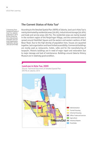
According to the Detailed Spatial Plan (RDTR) of Jakarta, land use in Kota Tua is mainly dominated by residential areas (30.9%), industrial and storage (30.16%) and trade and service areas (28.7%). The residential areas are mainly located in the northern region of the Penjaringan Village, and the commercial area is spread around Fatahillah Square and the eastern and western sections of Kali Besar Road. Due to the high density of population here, houses are squashed together, lack organization and have limited accessibility. Commercial buildings are mostly used as restaurants, hotels, cafes and for the manufacturing of tarpaulin. Historic buildings are in need of major repair and restoration due to major damage and lack of maintenance. Buildings around Jakarta History Museum are in relatively good condition.
Land use in Kota Tua, 2009 Source: Technical Document of Detailed Spatial Plan (RDTR) of Jakarta, 2014
Administration Formal Housing Informal Housing Office Trade and service Agriculture Industry/Depots Pond/lake