Tune in when it’s happening
Volunteer to help
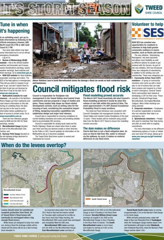
In an unfolding event, get up-todate information by listening to the official emergency channel, ABC North Coast 94.5 FM or ABC Gold Coast 91.7 FM. Your local radio station may have some information but is not an official emergency broadcaster. Log on to: • Bureau of Meteorology (BoM) website – this is the official weather watcher and forecaster and it issues severe thunderstorm warnings, severe weather warnings, flood watches and flood warnings. Go to www.bom.gov.au • NSW SES website for flood bulletins, evacuation warnings and orders. The SES is the lead agency in emergencies. Above: Holstons Lane in South Murwillumbah shows the damage a flood can wreak on both residential houses They tell you when to ‘prepare to go’ and businesses. and ‘to go’, but don’t expect them to be there to get you out because by that time it may be too late. Go to www.ses.nsw.gov.au • MyRoadInfo website for road Council is responsible for floodplain risk Flood modelling proved accurate closures – all councils in the Northern management in the Tweed Valleys and Coastal Creek The March 2017 flood essentially did what Council’s Rivers Region put their roadworks and catchments and has prepared a range of studies and flood-modelling predicted it would do when this road closure information on this site. plans. These studies help shape our flood-related volume of rain falls within this period of time. The During an unfolding flood, the data development controls, such as setting rules for the event approximated a 1% AEP (Annual Exceedance can lag due to the need to verify rezoning of land, considering the cumulative impact Probability) flood in many locations. information before publishing it or of filling, designing evacuation capabilities into The observed flood behaviour was consistent with lack of access to certain areas. Go to subdivision design and major land releases. Council’s floodplain risk management studies for the www.myroadinfo.com.au Council also is responsible for ensuring compliance to Tweed Valley and Coastal Creeks floodplains of the past There are two reference gauges current building standards and codes and providing suitable 13 years. These studies will be reviewed using actual used by BoM and the SES for flood land to accommodate SES services. data from the March 2017 flood to ensure the modelling warnings, namely: Council is responsible for closing local roads (not the remains accurate. 1. Murwillumbah Gauge (located Pacific Highway). Roads are closed when there is water in front of the Murwillumbah Civic over them and they are deemed unsafe or when directed The dam makes no difference Centre), and by the Police or SES. Council updates its information on the Clarrie Hall Dam is not a flood mitigation dam. As 2. Barneys Point Gauge (located on MyRoadInfo site as it becomes available. soon as Clarrie Hall Dam fills, water is released the old highway bridge abutment in The Tweed Shire flood levee system is owned and via the spillway. As such, it makes no material Chinderah Village). maintained by Council. difference to any flood event.
Council mitigates flood risk
NSW SES has unveiled new opportunities for residents to volunteer to help build greater community resilience in severe weather, such as floods and storms. The new initiative, ‘Volunteering Reimagined’, has been launched and allows more flexibility as well as different options for people to get involved with the Service. As part of this new initiative, SES has introduced three new categories of volunteering in addition to the existing core unit membership. These new categories are: 1. Community Action Team (CAT) members – A group of community members who come up with a local plan or set of actions that can help them prepare and respond to a flood or storm emergency. Several Tweed Shire communities have looked at developing a CAT for their area. These include: Chinderah/Fingal Head, Murwillumbah, Burringbar/Mooball, Tyalgum. More initial meetings are being planned 2. Corporate volunteers – Employees of a partner organisation or business who can volunteer their help in an emergency, and 3. Spontaneous volunteers – People who want to volunteer their help during and after an event with no ongoing commitment. For more information on the different volunteering options or to join or initiate your own local CAT group, please go to www.ses.nsw.gov.au/get-involved/ volunteer.
When do the levees overtop?
Murwillumbah levees Dorothy–William Street Murwillumbah CBD
South Tweed levee
South Murwillumbah East Murwillumbah
N
N
Levees should never be considerved complete protection from flood. All of Tweed Shire’s flood levees will eventually be overtopped when a big enough flood occurs. While levees are designed to keep river water out, during a flood the drainage outlets will be closed and the levee will act as a dam to keep local rainwater in.
An important observation from the March 2017 flood is that had the intense rainfall on Thursday night continued for as little as four hours more into Friday morning, the Murwillumbah CBD Levee would have overtopped and completely filled the CBD area. Murwillumbah CBD Levee overtops at 6.3m AHD on the Murwillumbah Gauge. East Murwillumbah Levee overtops at
Living and Loving the Tweed
approximately 6.3m AHD on the Murwillumbah Gauge or less if flooding in the Rous River is heavier. Dorothy/William Street Levee overtops at roughly 6.3m AHD on the Murwillumbah Gauge or less if flooding in the Rous River is heavier. The South Murwillumbah Levee is much lower and begins to overtop at 4.8m on the Murwillumbah Gauge.
Tweed Heads South Levee begins to overtop at approximately 2.2m on the Barney’s Point Gauge or Dry Dock Gauge. While not levee protected areas, water will begin to flow over Riverside Drive in Tumbulgum when the Tumbulgum Gauge reaches about 2.4m and floodwaters will begin to enter Chinderah, over Chinderah Bay Drive, when the Barney’s Point Gauge reaches about 1.6m.