Painted Hills Scenic Bikeway
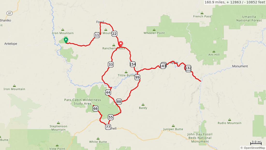
Num Dist Prev Type Note Next 0.0 miles. +0/-0 feet Num Dist Prev Type Note Next 1. 0.0 0.0 East on OR-218
John
Fossil Beds Nationa l Monum ent, Clarno Unit Scenic Bikeway route starts at the entrance to the trailhead and picnic area for the John Day Fossil Beds, Clarno Unit. Restroom s and water are available in the picnic area. 10.8 0.0 miles. +0/-0 feet Num Dist Prev Type Note Next 2. 10.8 10.8 Continu e on OR-218 Summit3,722 feet 5.4 3. 16.1 5.4 R on OR-19 Fossilstore, restauran t, lodging, camping 6.5 4. 22.7 6.5 Continu e on OR-19 Bear Hollow County Parkrestroom s, water, camping 2.5 22.7 miles. +697/-1106 feet Num Dist Prev Type Note Next 5. 25.2 2.5 Continu e on OR-19 Butte Creek Summit3,790 feet 0.9 6. 26.1 0.9 R on Rowe Creek Rd 1.3 7. 27.4 1.3 Continu e on Rowe Creek Rd Summit3,835 feet 10.6 4.7 miles. +309/-280 feet
from
Day
miles.
miles. +2068/-47 feet
Num Dist Prev Type Note Next 8. 38.0 10.6 Continu e on Twicke nham Rd Road name changes 3.1 9. 41.1 3.1 Continu e across John Day River Twickenh amrestroom s 0.1
Num Dist Prev Type Note Next 10. 41.2 0.1 Bear L on Twicke nham Rd/Gird s Creek Rd 7.3 11. 48.5 7.3 R on OR-207 3.5 12. 52.0 3.5 Continu e on OR-207 Summit3,594 feet 6.3
Num Dist Prev Type Note Next 13. 58.3 6.3 R on US-26 Mitchell 0.4 mile eaststore, restauran t, water, lodging, camping 3.4 14. 61.6 3.4 R on Burnt Ranch Rd 5.6 15. 67.2 5.6 L on Bear Creek Rd Gravel road 0.4 15.3
+95/-877 feet Num Dist Prev Type Note Next 16. 67.6 0.4 L to picnic area John Day Fossil Beds National Monume nt, Painted Hills Unitrestroom s, water, no camping. Return to Bear Creek Rd to continue route 0.4 17. 68.0 0.4 R on Bear Creek Rd 0.4 0.8 miles. +6/-6 feet
13.8
+85/-205 feet
10.9
miles.
miles. +1882/-258 feet
12.2 miles. +1090/-1005 feet
Num Dist Prev Type Note Next 18. 68.4 0.4 R on Burnt Ranch Rd 5.6 19. 74.0 5.6 L on US-26 3.4 20. 77.4 3.4 L on OR-207 Mitchell 0.4 mile eaststore, restauran t, water, lodging, camping 6.3 21. 83.6 6.3 Continu e on OR-207 Summit3,594 feet 3.5 15.6
Num Dist Prev Type Note Next 22. 87.1 3.5 Continu e on OR-207 1.9 23. 89.0 1.9 Continu e on OR-207 Mabe Hill Summit3,561 feet 6.8 24. 95.9 6.8 Continu e on OR-207 Waldron Summit3,165 feet 5.0
Num Dist Prev Type Note Next 25. 100.9 5.0 Continu e on OR-207 Service Creek Campgro und (BLM)restroom s, no water 0.3 26. 101.2 0.3 R on OR19/OR207 2.0 5.3 miles. +14/-2 feet Num Dist Prev Type Note Next 27. 103.2 2.0 Continu e on OR19/OR207 Mulesho e Campgro und (BLM)restroom s, no water 10.4 28. 113.6 10.4 Continu e on OR19/OR207 Spraystore, restauran t, lodging, camping 0.2 12.4
miles. +390/-291 feet
Num Dist Prev Type Note Next 29. 113.8 0.2 Bear L on OR19/OR207 Spray River Front Park 0.3 mile to the right on Parrish Creek Rdrestroom s, water, camping 2.8 30. 116.6 2.8 Continu e on OR-19 3.6
feet Num Dist Prev Type Note Next 31. 120.2 3.6 Continu e on OR-19 Shady Grove Day Use arearestroom s, no water 6.1
3.0 miles. +180/-185
feet Num Dist Prev Type Note Next 32. 126.3 6.1 Return west on OR19 to continu e route or continu e onto Old West Scenic Bikewa y Kimberly - store 6.1 6.1 miles. +0/-0 feet Num Dist Prev Type Note Next 33. 132.4 6.1 Continu e on OR-19 Shady Grove Day Use arearestroom s, no water 3.6 34. 136.0 3.6 Continu e on OR19/OR207 2.7 9.7 miles.
feet
3.6 miles. +0/-0
+140/-131
Num Dist Prev Type Note Next 35. 138.7 2.7 Continu e on OR19/OR207 Spray River Front Park 0.3 mile to the left on Parrish Creek Rdrestroom s, water, camping 0.3 2.7 miles. +0/-0 feet Num Dist Prev Type Note Next 36. 139.0 0.3 Continu e on OR19/OR207 Spraystore, restauran t, lodging, camping 10.4 37. 149.4 10.4 Continu e on OR19/OR207 Mulesho e Campgro und (BLM)restroom s, no water 2.0 10.7 miles. +290/-389 feet Num Dist Prev Type Note Next 38. 151.4 2.0 Continu e on OR-19 0.3 39. 151.7 0.3 Continu e on OR-19 Service Creekstore, restauran t, lodging 7.9 40. 159.6 7.9 Continu e on OR-19 Julia Henders on Pioneer Parkrestroom s, water, no camping 0.8 10.2 miles. +1434/-4 feet Num Dist Prev Type Note Next 41. 160.4 0.8 Continu e on OR-19 Sheldon Wayside County Parkrestroom s, camping 0.5 42. 160.9 0.5 End of route 0.0 1.3 miles. +108/-0 feet