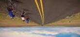
The Cascading Rivers Scenic Bikeway follows the Clackamas and Breitenbush rivers in a 70-mile link on backroads from Estacada to Detroit. Water is the dominant force sculpting this steep volcanic landscape of the West Cascades. All along this route, water and rock interact to create a place of dramatic beauty and inspiration. The bikeway parallels the nationally designated Wild and Scenic Clackamas River along rocky ri es and quiet pools where native coho, chinook and steelhead seek their ancient spawning beds. Time is forgotten as you look up to the sky through ancient forests that line the bikeway. You may experience glimpses of elk and grouse, or rest along the route to
5
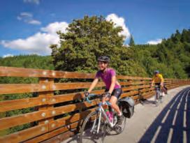
Explore Oregon’s Scenic Bikeways!
In 2009, Oregon became the first state to develop a statewide Scenic Bikeway program. Ten years later this innovative program now includes 17 designated bicycle routes that showcase Oregon’s breathtaking landscapes, cultural treasures and western hospitality.
Scenic Bikeways are Oregon’s best of the best bicycle rides for exploring this beautiful state. Everyone can find a ride that fits their style, from a half-day, family-friendly outing to a multi-day, remote and challenging route. Ride one or connect a

Safety Tips
Please be aware that the bikeway information here is only advisory. You assume all risks as far as the quality and accuracy of the information; in other words, you’re agreeing to use it at your own risk. Scenic Bikeway
routes include roads with car and truck tra c, and are for cyclists that are comfortable riding in some amount of tra c. Cyclists must obey the rules of the road. For car-free riding, check out the Banks-Vernonia State Trail on the Tualatin Valley Bikeway and the Row River Trail section of the Covered Bridges Bikeway.
A must-know: in Oregon, a bicycle is legally considered a vehicle (and the same laws apply). Riding with the direction of tra c is the law; it’s also the best way to be seen by motorists.
To demonstrate the best riding etiquette and promote good relations with motorists, please ride single-file.
Riding side-by-side is legal, but only if doing so does not impede tra c. Be aware that many rural roads are used daily for commerce; there’s a good chance you’ll encounter large trucks carrying oversized loads.

Never forget about drivers’ blind spots—especially when the vehicle is turning right. If you’re going straight at an intersection with stopped vehicles, pull in behind the first stopped vehicle in the lane and wait your turn to go, as if you were a motorist.
farm equipment and wildlife. Be visible and predictable, and practice riding etiquette when others are on the road. In Oregon, a bicycle is legally considered a vehicle and falls under the same laws. Riders under 16 must wear a helmet and we strongly encourage all that enjoy the bikeways to wear a helmet throughout their trip.
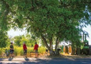
For local supporters, bikeway designation is just the beginning. Locals help maintain and promote routes. They identify desired services and seek grants, volunteers and partners for development and maintenance. Local pride in the bikeways is high and is often expressed through special events and annual rides. Help celebrate these bikeways with residents and fellow cyclists by checking the yearly calendar. Enjoy Oregon. Bring your bike, your gear and your sense of adventure.
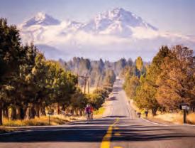
A lightly traveled gem, the out-and-back Crooked River Canyon Scenic Bikeway o ers a destination-based reward: a narrow, twisting canyon in Central Oregon that removes you from today’s world and takes your imagination back to the Wild West of yore. Geographically, the route basically funnels you right to the payo – an oasis of water-based recreation. The ride begins at Rimrock City Park in Prineville, where in about two minutes you can go from “in town” to “out of town,” as the rural vibe quickly takes over. The sky stretches wide, out to horizons serrated by the Powell Buttes, the Bear Creek Butte and the formidable Ochoco Mountains. The ride starts flat and easy, winding through an agricultural valley as the river meanders in lazy “S” curves. Farther in, the terrain narrows into canyonlands, as the river comes in close and the look of the ride gets more rugged. It feels like the rock engulfs you, and your eyes can feast on a surprising variety of flora, as well as subtle color changes of di erent light on the rock walls. The river is a constant companion for the rest of the ride. The turnaround point is Big Bend campground where you can turn around and enjoy the entire ride in reverse, which is just as visually invigorating as the ride up.
Camping and lodging: on the route there are no fewer than nine BLM campgrounds: Castle Rock, Stillwater, Lone Pine, Palisades, Chimney Rock, Cobble Rock, Post Pile, Poison Butte and Big Bend. Only Chimney Rock and Big Bend have water. There are multiple lodging options in Prineville, as well as an RV park near the start. Distance: 37 miles (out-and-back)
ride: Spring through fall


RideOregonRide.com/CrookedRiver Designated in 2018
All bicycle riders in Oregon under 16 must wear a helmet. Oregon law also requires that bicycle riders have a white light in front and a rear red light or reflector during night or limited visibility.
For more information on riding safely and legally in Oregon, go to: Oregon.gov/odot/hwy/bikeped

Please check RideOregonRide.com/Bikeways for new routes.
Oregon Department of Transportation
Coverphoto: Painted Hills ScenicBikeway


14
Covered
outback of stunning mountain vistas with views of the Elkhorn Range, the Blue Mountains and the Eagle Caps of the Wallowa Mountains. The halfway point is picturesque Baker City, a great overnight spot.
The Painted Hills Scenic Bikeway is located in an area of the state many native Oregonians have never been to or even heard of. You can discover the multi-colored John Day Fossil Beds on 130 miles that connect the small communities of Fossil, Service Creek, Spray, Kimberly, Mitchell and the John Day Fossil Beds National Monument. Viewed from your bicycle seat, you can see millions of years of history revealed in the layers of earth, one color at a time. The hills get their name from the delicately colored stratifications in the soil—ribbons of yellows, golds, blacks, and reds formed millions of
Starting at the edge of an urban setting, the Tualatin Valley Scenic Bikeway lets you quickly escape to gently undulating roads in the lush Tualatin River basin, dotted with wetlands, small forests and views of the Coast Range. A zig-zag route takes you past produce stands, a farmers’ market and a winery, and through the quaint communities of Forest Grove and Banks. In Banks you connect to the splendid Banks-Vernonia State Trail, a paved path constructed on a scenic old railroad bed. The trail climbs slightly and then more significantly, but the generally gentle rail bed never gets too steep. The trail starts amid hay fields and pastures and transitions to deep forest, featuring a spectacular curving trestle and multiple rest areas. Head all the way to revitalized Vernonia or turn around at any point.
Camping and lodging: camping is available at L.L. Stub Stewart State Park. There are multiple lodging options in Hillsboro, Forest Grove and Vernonia.
Distance: 51 miles (one way)

Level: Moderate
Best seasons to ride: Year-round RideOregonRide.com/TualatinValley
Designated in 2013
15
Camping and lodging: campgrounds with hiker/biker sites are available at Clyde Holiday State Recreation Site and Bates State Park. Several other campgrounds are along the route, most without water. There is one bike hostel along the route in Mitchell, and lodging is available in John Day, Dayville and Long Creek.
Distance: 174 miles (loop) Level: Challenging Best seasons to ride: Late spring through fall RideOregonRide.com/OldWest Designated in 2011
10
The Oregon Outback Scenic Bikeway o ers an immersion in a part of Oregon too few people visit and enjoy. For the hardy rider, it’s a chance to take in panoramic views, revel in quiet solitude and traverse rugged and challenging terrain. The remote route is nestled in the untrammeled Warner Mountains, where the forested Cascades meet the high-desert basin and range. The “lollipop” configuration starts and ends in
restrooms and drinking water. The moment you leave town, you’ll savor the solitude—it’s just you, your bicycle and the glorious views.
Camping and lodging: camping is available at Shelton County Wayside Park, between Fossil and Service Creek. Lodging options are also available in Fossil, Mitchell, Service Creek, Spray and Kimberly.

The Twin Bridges Scenic Bikeway shows you some of the most sublime scenery in Central Oregon: snow-capped mountains, rimrock canyons, high-desert rangeland and the Deschutes River. The ride starts in bustling downtown Bend, Central Oregon’s outdoor adventure capital. Start at Drake Park, where the Deschutes is slow enough to form jewel-like Mirror Pond. Roll out of town using wide bike lanes, into the pine-scented high desert, crossing Tumalo Creek as you descend into the natural beauty of Shevlin Park at a horseshoe bend. Climb back up and pass horse pastures, llama farms and cattle ranches, enjoying a continuing dance with the Deschutes as you skirt rugged canyon edges above it and then drop down to cross it multiple times; take a few minutes to soak your feet in the river during a stop at gorgeous Tumalo State Park. This route definitely has some up-and-down, but there are no steep, extended climbs, and it’s a great way to enjoy a pleasant few hours meandering through the spectacular setting on a bike.
Camping and lodging: camping, with hiker/biker sites, is available at Tumalo State Park, at mile 27. There are multiple lodging options in Bend.
Distance: 36 miles (loop) Level: Moderate


Best seasons to ride: Spring through fall RideOregonRide.com/TwinBridges Designated in 2012
oasis of the city park in Maupin, a hub town for outdoor adventurers that is friendly, walkable, and brimming with eating and drinking opportunities. Start by climbing up through town and onto the high plateau between the White River and the Deschutes, which twists and rolls behind and below you. A 1,000-foot climb pays o with a long, swooping descent down a rock sidewall, dipping into Tygh Valley. Four miles beyond town, don’t miss the spectacular plunging water at White River Falls State Park. Then navigate your own drop – 500 feet down to the Deschutes riverbed. The route follows the river’s course through the canyon to the finish, passing the bikeway’s namesake Sherars Falls, where Native Americans fish for salmon from wooden sca olds, using traditional dip-and-set nets as they have for thousands of years.
Camping and lodging: on the route there are four BLM campgrounds: White River, Oak Springs, Blue Hole and Oasis; none of them have water. There are multiple lodging options in Maupin.
Distance: 33 miles (loop) Level: Moderate Best seasons to ride: Year-round
options in Lakeview and Plush.
Distance: 90 miles (modified loop) Level: Extreme Best seasons to ride: Year-round (spring and fall are best) RideOregonRide.com/Outback Designated in 2016
Cascade Siskiyou Scenic Bikeway One of Oregon’s scenic trademarks is its snow-capped volcanic peaks. The Madras Mountain Views Scenic Bikeway delivers no fewer than seven spectacular mountains as a backdrop. Start and end in Madras; within a mile
your start you’ll
cruising
bucolic countryside
smoothly
road
midst
expansive sage-and-juniper ecosystem. As
pedal
small communities
Culver
Metolius, you’ll
past an agricultural bounty of mixed crops, including grass, onion
carrot seed; garlic, potatoes, wheat and alfalfa;
lavender and mint. Basalt palisades loom above the meandering Deschutes and Crooked rivers, and scenic overlooks of The Cove Palisades State Park and Lake Billy Chinook o er stunning photo opportunities. You may not encounter a passing car for miles while you take in views of the singular silhouettes of Mount Je erson, the Three Sisters, Mount Hood, Broken Top and Three-Fingered Jack. Camping and lodging: camping is available at The Cove Palisades State Park. Multiple lodging options in Madras. Distance: 29 miles (loop) Level: Moderate Best seasons to ride: Year-round RideOregonRide.com/Madras Designated in 2013 McKenzie Pass Scenic Bikeway one of the most spectacular routes in the country, is best started in the Old West town of Sisters. Ride out of town through the ponderosa pines of the Cascades, rise through a steady, extended climb, and emerge into a lava-rock moonscape at the top. Spin down the west slope through Douglas fir forest to the soothing waters of Belknap Hot Springs on the McKenzie River, or turn back toward Sisters. This ride is strenuous and appropriate only for seasoned riders. Most of Oregon Route 242 is closed during winter months, but accessible to bicycles in the spring before it reopens to cars, providing tra c-free road riding on the top sections. Check www.tripcheck.com for current road closures. Always be sure to share the road, and remember that even when the road is closed to vehicular tra c, bicyclists are riding the route in both directions and need to follow tra c laws. Camping and lodging: camping is available at either end, in Sisters and Belknap Hot Springs. There are campsites along the route, but they don’t have water. There are multiple lodging options along the McKenzie River and in Sisters. Distance: 38 miles (one way) Level: Extreme Best seasons to ride: Summer and fall RideOregonRide.com/McKenziePass Designated in 2011 3 7 8 4 PHOTO: NATALIE INOUYE 9 Here’s a rugged piece of the Old West you can check out by bike —the Old West Scenic Bikeway o ers a wide variety of terrain and scenery, from rushing rivers to views of the Strawberry Mountains to fossil beds, plus some climbs that will get your attention. Start in John Day with a tour of Kam Wah Chung State Heritage Site, once a general store for Chinese immigrants in the late 19th century. Then roll east on Highway 26 through picturesque Prairie City, and on to the turno at Austin Junction. Leave the highway for truly rural back roads and ride along the Upper Middle Fork of the John Day River, where the distances spread out and the sky gets even bigger. Ride through rugged terrain that still looks the same as when the area’s early settlers arrived. You’ll pass through tiny, friendly towns as you ride to the John Day Fossil Beds, then reconnect with Highway 26 back to John Day. This ride is for serious touring cyclists—it works well as a multi-day trip, but be sure to plan carefully; there is no water available between Bates State Park and Long Creek.
5/2023
of
be
through the
on a
paved
in the
of an
you
through the
of
and
roll
and
and
a symphony of forest songbirds, as vistas of Mount Hood and Mount Je erson smile down. Enjoy a walk through the towns of Estacada and Detroit, which anchor either end of the bikeway. Camping and lodging: camping is available in Forest Service campgrounds along the route and at both ends: Milo McIver State Park, outside Estacada, has hiker/biker sites; Detroit Lake State Recreation Area is in Detroit. Distance: 71 miles (one way) Level: Challenging Best seasons to ride: Late spring through early fall RideOregonRide.com/CascadingRivers Designated in 2014 The Covered Bridges Scenic Bikeway features a fun cycling experience of bridges, lake views, foliage, flowers and an historic downtown. The start of the bikeway is along the Row River Trail, an o -street, paved path which crosses the roads at several points. The return route is on a low tra c scenic road with one very short, yet very steep hill. The Row River Trail runs along the Dorena Lake’s north side, passing three of the six covered bridges on the route. All three of these bridges are listed in the National Register of Historic Places. A store in the modest community of Dorena provides snacks. The in-town part of the bikeway includes a ride through the Chambers Bridge, a historic railroad bridge that was built in 1925 and restored in 2011 for pedestrian and bicycle crossing. Cottage Grove is a National Register-listed Downtown Historic District. There are number of co ee shops, restaurants, pubs and a bike shop on Main Street. Camping and lodging: camping is available at Baker Bay Park. There are multiple lodging options in Cottage Grove. Distance: 36 miles (loop) Level: Mild Best seasons to ride: Year-round RideOregonRide.com/CoveredBridges Designated in 2012 12 Sherar’s Falls Scenic Bikeway is a topographically diverse loop through Central Oregon’s “Deschutes River Canyon Country” that encircles the high-desert chasm of the Deschutes River, and also includes expansive open prairie above the river. It showcases a beautiful stretch of a riverside road that became a “must-ride” for roadies when it was paved after decades as a gravel access road for river rafters. The route begins and ends at the shady
(spring and fall are best) RideOregonRide.com/SherarsFalls Designated in 2017 13 The Sisters to Smith Rock Scenic Bikeway provides riders with stunning views of the spectacular Cascade Mountains. Start in downtown Sisters and roll by fertile pastures before dropping into a quiet canyon far from towns and highways. Cross the tranquil Deschutes River at Lower Bridge, and then wind your way through the town of Terrebonne and on to the end of the route at the dramatic walls of Smith Rock. Hike along the river, watch rock climbers from all over the world scale the famous Monkey Face, or bike up Misery Ridge for close-up views of rock formations outlined by the Cascades in the distance. This ride is generally downhill from Sisters with some rolling hills; ride it starting from Smith Rock State Park to make it a bit more challenging. Camping and lodging: camping is available in Sisters, which also has multiple lodging options. Bivouac camping is at Smith Rock State Park Distance: 37 miles (one way) Level: Moderate Best seasons to ride: Spring through fall RideOregonRide.com/SistersToSmithRock Designated in 2011 16 A Wild and Scenic River, lush cranberry bogs, towering basalt sea stacks and vast ocean views await riders on the Wild Rivers Coast Scenic Bikeway The 61-mile route is anchored in the fishing hamlet of Port Orford, the oldest town on the Oregon Coast. You can complete the route in one day or take your time with several outand-back rides. A perfect start point is at historic Battle Rock Park in Port Orford, with views of Redfish Rocks Marine Reserve. A 17mile stretch in the Rogue River-Siskiyou National Forest follows the Wild and Scenic Elk River,
old-growth forest
pools teeming
salmon
trout.
Elk River Fish Hatchery
one
many swimming holes. A steady, gentle climb brings you to Cape Blanco State Park,
the westernmost point of Oregon and home to Cape Blanco Lighthouse, the state’s oldest working lighthouse, built in 1870. Another out-and-back ride just a few easy miles from Port Orford leads to Paradise Point State Recreation Site, where you can pedal up to a sandy beach for perfect sunset views. Camping and lodging: camping, with hiker/biker sites, is available at Cape Blanco State Park and at Humbug Mountain State Park. There are two Forest Service campgrounds on River Road, but they don’t have water. Lodging in Port Orford. Distance: 61 miles (out-and-back) Level: Moderate Best seasons to ride: Year-round RideOregonRide.com/WildRiversCoast Designated in 2015 17 The original Oregon Scenic Bikeway, this route showcases one of the most productive—and beautiful—agricultural valleys in the world, known for world-class pinot noir. Between the winery views, you’ll pass through a series of enchanting small towns along the way. The Willamette Valley Scenic Bikeway starts at historic Champoeg State Heritage Area. The route follows its namesake river as it winds through the Willamette Valley. You’ll pass an amazing bounty of crops, from flowers to hops and nuts to berries. This route is ideal for almost any rider; it has very little climbing. Camping and lodging: hiker/biker camping is available at the north end of the route at Champoeg State Park and at Willamette Mission State Park. Camping is also available in Brownsville at Pioneer City Park and at Armitage County Park at the south end of the route. There are multiple lodging options in several towns along the route, including Keizer, Salem, Independence, Albany and Eugene. Distance: 134 miles (one way) Level: Moderate Best seasons to ride: Year-round RideOregonRide.com/Willamette Designated in 2009 A century ride can imply that it can be ridden in one day. This bikeway is not that kind of century. There are plenty of rollers and two big hills with a total elevation gain of about 8,000 feet. The Blue Mountain Century Scenic Bikeway is perfect for riders looking for a physical challenge in a remote and beautiful setting. Breathtaking views of the Blue Mountains, well-maintained roads and barely any vehicle tra c make this bikeway a cycling paradise. The 108mile bikeway is a scenic loop starting and ending in Heppner—a full service community. The route follows Highway 395, climbing 3,280 feet followed by an exhilarating downhill to Ukiah, where you can find overnight accommodations, a grocery store and a cafe. Mountain prairies o er a wide array of wildflowers, while the forest is augmented with color in the late summer as the Western Larch trees turn a golden yellow. Forest Service Road 53 is closed in winter due to snow. Camping and lodging: camping is available just outside Heppner at Willow Creek Reservoir and along the route at Cutsforth Park, Coalmine Campground and Ukiah-Dale State Scenic Corridor. Lodging options are also available in Heppner and Ukiah. Distance: 108 miles (loop) Level: Extreme Best seasons to ride: Early summer and fall RideOregonRide.com/BlueMtn Designated in 2011 The Cascade Siskiyou Scenic Bikeway incorporates 5,000 feet of steep and winding climbing through oak savannah into fir forests. The bikeway starts in Ashland, famous for theater and fantastic dining, climbing mountainsides with spectacular views of the Bear Creek Valley below and Pilot Rock. In spring, wildflowers cover this savannah ecosystem as red-tailed hawks soar overhead. Above the oak savannah is the Cascades ecosystem, with tall pines and Douglas firs providing welcome shade on the way to Green Springs Summit. Take the 5-mile out-and-back to historic Tub Springs State Wayside and a cold, pure mountain spring. Near Hyatt Reservoir you’ll see views of 9,000-foot Mount McLoughlin, with glimpses of osprey and bald eagles nesting. The ride culminates with a 3-mile climb through alpine meadows of Lily Glen and Buck Prairie before a thrilling, winding 13-mile descent back to Ashland. Camping and lodging: camping is available along the route at Green Springs, Hyatt Reservoir and Howard Prairie Lake. There are multiple lodging options in Ashland. Distance: 55 miles (loop) Level: Extreme Best seasons to ride: Spring through fall RideOregonRide.com/CascadeSiskiyou Designated in 2015 1 2 PHOTO: SEAN BAGSHAW The Grande Tour Scenic Bikeway in northeastern Oregon o ers cycling opportunities for every rider. Adventure cyclists seeking a challenging ride can try the entire 134 mile “figure-8” route. Cyclists wanting a more leisurely trip can ride segments of the route and can use public transit to return to their start point. All riders will experience Oregon’s
through an
and past
with native
and
Visit the
or cool o at
of
on
134 miles (loop) Level: Challenging Best seasons to ride: Spring through
RideOregonRide.com/GrandeTour
2012
Camping and lodging: camping is available at Catherine Creek State Park. There are multiple lodging options in La Grande and Baker City. Distance:
fall
Designated in
6
Best seasons to
Level: Moderate
Lakeview, which sits at nearly a mile in elevation. Start with a stout 10-mile climb up to Warner Canyon Ski Area; after riding high for another 20 miles, glide down 1,300 feet to the friendly community of Plush. From there, rolling landscape passes near Hart Lake and skirts Crump Lake as you share wide-open terrain with sandhill cranes, sage grouse, wetland birds, pronghorn and even bighorn sheep. At 59 miles, a narrow canyon squeezes you past Deep Creek Falls, where you might see cli swallows, eagles and falcons in the skies above before you climb back up to the ski area and drop back down into Lakeview. This ride is best in spring and fall; spring snowmelt draws migrating birds and wildflowers bloom. Fall mating season brings out antelope and mule deer, amid quaking aspen in brilliant yellow. Camping and lodging: there are several camping options on the route, including Mud Creek campground and Drake Peak Lookout, which are near (but not on) the route. Dispersed camping on BLM land is allowed near Priday Reservoir. None of these options have water. There are lodging and camping
years ago by shifting volcanic islands. The ancient plant and wood fossils found here reveal 50 million years of evolution. You’ll ride through land where early cousins of elephants and rhinos once roamed. The bikeway is a loop made up of a series of hilly, remote out-and-back rides through high desert. One stretch runs along 20 miles of the John Day River, and another treats you to views of the Sutton Mountain Wilderness Study Area. You can start and end your ride in any of the communities on the bikeway—each has amenities and supplies. Many parks and interpretive areas along the route have
Distance:
miles
Level: Extreme Best seasons to ride: Late spring through fall RideOregonRide.com/PaintedHills Designated in 2016 11
161
(loop and out and back options)
Bridges
Wild Rivers Coast Scenic Bikeway
Scenic Bikeway
series of bikeways for an epic adventure. O cial route signs are posted along each bikeway. Scenic Bikeways are nominated by locals and then tested and vetted by a statewide advisory committee of cyclists, regional tourism providers and regional partners. Everything you need to plan your trip is at RideOregonRide.com/Bikeways Detailed, downloadable maps and GPS files Short videos describing each bikeway Information on State Park facilities, bike-friendly lodging, camping, dining and more Guide and shuttle companies • Cycling events Please be aware of your surroundings — routes may involve sharing the road with cars, trucks,
Be sure to look for businesses with these signs. They provide a warm welcome and various services for cyclists. Painted Hills Scenic Bikeway Crooked River Canyon Bikeway