AREA
Lakes& Fishing BUFFALO LAKE
2,210-acres; 8-foot depth; panfish, bass and pike. West of State Highway 22, Montello.
CRYSTAL LAKE
27-acres; 12-foot depth; panfish, bass and pike. County Road P, east of Pardeeville, approximately 1.5 miles to Pardeeville Road. This lake has walkin access only, carry-in for canoes, kayaks, etc. No developed boat ramp.
LAKE COLUMBIA
A man-made lake heated by the Alliant Energy generating plant. This lake stays ice free and features year-round open-water fishing: bass and catfish. State Highway 51 south to County Road V. Public access to Lake Columbia: enter from County Road V/J via the driveway and drive back to the parking area to the launch area on the southeast side of the lake. There is no boat ramp, anglers are limited to boats they can carry down to the water, and only electric trolling motors are allowed (the motor rules are posted on a sign on the chainlink fence next to the parking area). Fish from shore as well.
LAKE GEORGE
36-acres; 22-foot depth; panfish, bass and pike. County Road P, between Portage and Pardeeville. Use of motor-powered craft is prohibited.
LAKE WISCONSIN
9,000-acres; 39-foot depth; panfish, bass, pike, walleye, sauger, muskie, sturgeon and channel and flathead catfish. Interstate 90/94 to County Road CS, exit at Poynette. 16 | portagewi.com
MASON LAKE
885-acres; 9-foot depth; panfish, bass and pike. State Highway 127 to County Road AA in Briggsville, 12 miles from Portage.
PARK LAKE
312-acres; 27-foot depth; panfish, bass, pike, walleye and channel catfish. Between State Highways 44 and 22 in Pardeeville.
SILVER LAKE
74-acres; 42-foot depth; panfish, bass, pike and muskie. Silver Lake Drive off of State Highway 16 or Haertel Street off State Highway 51 in Portage.
SPRING LAKE
24-acres; 32-foot depth; panfish, bass, pike, walleye and channel catfish. Just off State Highway 22 in Pardeeville. No gasoline-powered boat motors are allowed on Spring Lake.
SWAN LAKE
406-acres; 82-foot depth; panfish, bass, pike, walleye, muskie and channel catfish. Off either State Highway 33 or County Road P, between Portage and Pardeeville.
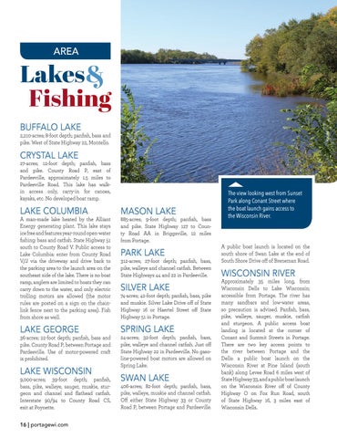
The view looking west from Sunset Park along Conant Street where the boat launch gains access to the Wisconsin River.
A public boat launch is located on the south shore of Swan Lake at the end of South Shore Drive off of Breneman Road.
WISCONSIN RIVER
Approximately 35 miles long, from Wisconsin Dells to Lake Wisconsin; accessible from Portage. The river has many sandbars and low-water areas, so precaution is advised. Panfish, bass, pike, walleye, sauger, muskie, catfish and sturgeon. A public access boat landing is located at the corner of Conant and Summit Streets in Portage. There are two key access points to the river between Portage and the Dells: a public boat launch on the Wisconsin River at Pine Island (south bank) along Levee Road 6 miles west of State Highway 33, and a public boat launch on the Wisconsin River off of County Highway O on Fox Run Road, south of State Highway 16, 3 miles east of Wisconsin Dells.


