4 minute read
Smart Neighborhood Cibangkong


North Boundary: Cikudapateuh-Ciwidey Old Railway
West Boundary: Laswi Street and PT Koppeland
Advertisement
East Boundary: Cikudapateuh-Ciwidey Old Railway
One of metropolitan city in Indonesia, Bandung has the third highest population in Indonesia after Jakarta and Surabaya. Historically, Bandung was originally developed as a resort city in the 1800s by the Dutch Indies Government due to its rich natural and comfortable climate. Nowadays, Bandung has become large scale city for political, economic, and social activity in Indonesia. However, Bandung, like the other big cities also experience urban housing problem such as the slums and informal settlement. The mayor of Bandung has signed the Decree of Mayor No. 648/Kep.286Distarcip/2015 on the Determination of the Slum Areas in Bandung. Several RW or neighborhood group in Cibangkong, a ward in west of Bandung central area, has been indicated as slum area. On the other hand, Cibangkong is one of the strategic areas based on Bandung City Detailed Spatial Plan as Karyapolis so the development of the area aims to support the commercial, business, and office center. Parts of land were acquired by private sector and had turned into commercial center and major part of the slum area also are standing on the land owned by the national Indonesia Train Company (KAI) and looked forward to have a new commercial development. Therefore, it is important to develop the slum area of CIbangkong, especially in fields of housing provision.
The housing planning is required to be improved not only the condition but also the provision of the housing especially for the low income households. Therefore, the concept of the new development without setting aside the existing households living in the area need to be planned thoroughly by identifying potential driving forces in future. Furthermore, the low income households are expected to be shareholders from the new development of the area to generating their income and improve their welfare.
This housing planning studio identified four RW in Cibangkong; RW 13, RW 12, RW 11, and RW 5. The area is 14.14 Ha and there are 2,472 household units. Cibangkong is a part of Batununggal District, Bandung Municipality. The identified four RW considers their location as strategic. It is located close to the major road and also near the railway. However, those who have their houses sit on top of KAI land which had an abandoned rail track. This railtrack is planned to be reactivated. Despite the unfortunate situation, many see this as potential as the land price of the area is predicted will increase. Another private sector already acquired few acres of land in RW 11 which planned to be developed to commercial apartment.

The activities of this housing planning studio are divided into 3 activities, namely:
(1) Class activities including lecture, presentation and writing structure of the housing studio report and assignment such as literature review, driving forces and scenario planning, and presentation progress of housing studio every week;
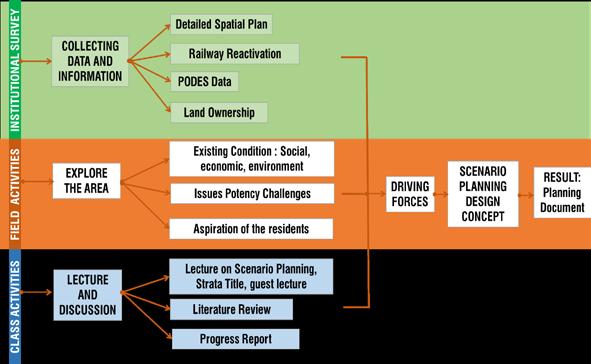
(2) Field activities including the inspection, Focused Group Discussion (FGD), interview, and questionnaire distribution of households; and
(3) Institutional Survey including collecting data and information to the related stakeholders. The three activities are conducted simultaneously from the start of the week until the final week
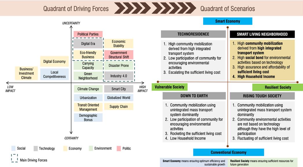
SOCIAL: urbanization, globalized world, demographic bonus, local competitiveness
TECHNOLOGY: internet of things/digital era, the evolution of industry 4.0, smart city
ECONOMY: economic stability, eco-friendly business, transit oriented management, supply chain, digital economy, business/climate investment
ENVIRONMENT: climate change, carrying capacity, disaster prone, green neighborhood

POLITICS:
HIGH POSSIBILITY OF EVICTION
In order to recognize the driving forces which might influence the study area, Steep Analysis is conducted. Steep Analysis is tool for determining driving force by evaluating external factors influence the area development and it is commonly used in business analysis. With this analysis concluded the possible scenario planning and driving force.
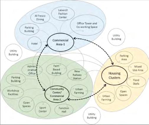
The diagram above illustrates the connection between primary functional spaces with each other. Each primary function is connected to administrative office, faith based building, and new railway station. For commercial area-1, spaces within the area are connected with each other including hotel, alfresco dining, local craft center that we named “Laswicit”, office tower and co-working spaces. These spaces are also connected to parking area in each building and supported by utility building which provide services to this particular area. The housing clusters are connected to several functional spaces namely mixed use are, parking area, open spaces and urban farming. This primary function also supported by utility building in each housing tower. Urban farming in this area is part of bigger urban farming in community center/ commercial area-2. The community center/commercial area-2 is connected to more complex functional spaces which are administrative office, faith based building, new railway station, urban farming, function hall, sport center, open spaces, workshop facilities and parking . Here, the center of all community’s activities will be placed
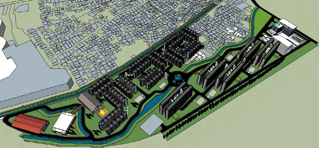
The redevelopment is designed in four phases in six years. The area also divided between North and South area. Each would have their own commercial area integrated to the neighborhood condition. The South commercial area consists of mixed use building, leisure & activities park, and community center. The North commercial area consists of local crafts center (Laswicit), Office Tower, and Hotel.
There are four development phases that would rotate the local civilliand to their new housing. Each development will give a milestone to the project with what additional it gives. For example, Phase 1 focus on the initial development and introduce the new vertical housing to the community and to the public. In the later phase, community center would be added and then more housing with commercial area, etc.


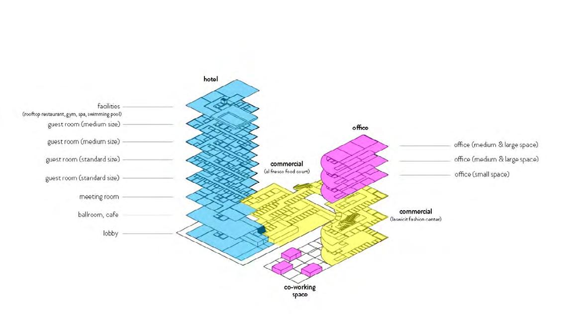
My role in this project is mostly focusing on developing Commercial Area. Commercial area - 1 will be built in previous area of RW 13, next to arterial secondary street (Laswi street). According to Bandung Detail Spatial Plan 2015-2035, the area near Laswi street can be built as commercial zone with building cover- age ratio 70 %. So from total area for commer- cial at 1,65 hectares, the built area approximate- ly 1,155 hectares. The floor average ratio is 5,6 and maximum floor is 8 floors. As part of Karees city area unit, Kelurahan Cibangkong will be de- veloped to fulfill the concept of “Karyapolis” or development of creative center area consists of commercial center, office center, and housing area.
The commercial area consists of 2 buildings. The first building is a 4 star-hotel consists of 8 floors. The first three floors are includ- ing lobby, ballroom and café, and other type of meeting rooms. The 4th and 5th floor will accommodate standard size guest rooms and the 6th and 7th floor will accommodate medium size guest rooms. The upper floor will contain facilities namely rooftop restaurant, gymnastic, spa and swimming pool.