Waterway Open Again by Gary D. Crawford
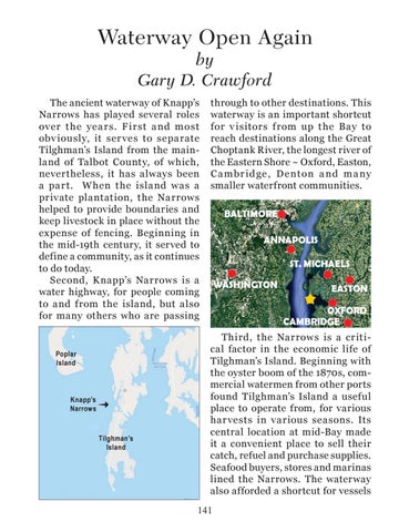
The ancient waterway of Knapp’s Narrows has played several roles over t he ye a r s. F i r st a nd most obv iously, it ser ves to separate Tilghman’s Island from the mainland of Talbot County, of which, nevertheless, it has always been a par t. When the island was a private plantation, the Narrows helped to provide boundaries and keep livestock in place without the expense of fencing. Beginning in the mid-19th century, it served to define a community, as it continues to do today. Second, K napp’s Narrows is a water highway, for people coming to and from the island, but also for many others who are passing
Poplar Island
Knapp’s Narrows
Tilghman’s Island
through to other destinations. This waterway is an important shortcut for v isitors f rom up t he Bay to reach destinations along the Great Choptank River, the longest river of the Eastern Shore ~ Oxford, Easton, C a mbr id ge , D e nton a nd m a ny smaller waterfront communities. BALTIMORE ANNAPOLIS ST. MICHAELS WASHINGTON
EASTON OXFORD CAMBRIDGE
Third, the Narrows is a critical factor in the economic life of Tilghman’s Island. Beginning with the oyster boom of the 1870s, commercial watermen from other ports found Tilghman’s Island a useful place to operate from, for various har vests in various seasons. Its central location at mid-Bay made it a convenient place to sell their catch, refuel and purchase supplies. Seafood buyers, stores and marinas lined the Narrows. The waterway also afforded a shortcut for vessels 141