9 minute read
Easy Mountain Bike Trails: North Lake Tahoe


Easy Mountain Bike Trails:
NORTH LAKE TAHOE
Advertisement
STORY & PHOTOS BY PRIYA HUTNER
AUTHOR’S NOTE: Read Priya’s feature on Easy Mountain Biking Trails in Truckee at TheTahoeWeekly. com. Due to ongoing fire danger and forest closures, she will explore South Shore trails next summer.
ere are some days
when a cruisy bike ride in the woods is just what the doctor ordered, and the Tahoe Sierra is known for its stellar mountain-bike terrain with trails for every type of rider. Tahoe’s mountain-biking trails o er challenging uphill ascents, technical terrain, big winding single-tracks and white-knuckle descents. Along the way, the gently rolling trails provide an opportunity to explore the forests and enjoy the beautiful environment that makes Tahoe one of the most spectacular places in the country.
Federal, state and local trails or parks may be closed due to fire danger or air quality impacts.
Check conditions before visiting.
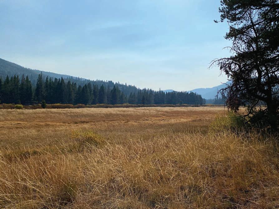
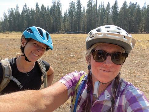
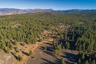
LEFT to RIGHT: Selfies on the ride; The trail to the meadow; Looking out across the meadow.
ere is something extraordinary about riding a bike on dirt in the woods away from busy roads. Immersing in nature is a top priority for most people who live and visit this area — and it’s healthy, too.
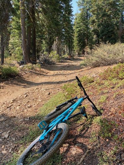
On a beautiful fall Sunday morning, my friend Lauren Kok and I set out for a mountain-bike ride to Page Meadows. Neither of us had ridden the Page Meadows loop and it is designated easy. We accessed the trail on Rawhide Drive o Granlibakken Road in Tahoe City. We parked at the end of the road where the trailhead starts. Once on our bikes, we started a steady but gentle climb up a re road. e forest was gorgeous and o ered a nice amount of shade from the sun. e re road eventually turned into a single track. e trail wasn’t technical and had few rocky sections. We wondered if this is why it was designated easy.
As we climbed, there were only a handful of people hiking and biking. Along the trail, there are several signs for Page Meadows. e last sign had two arrows, one pointed right and the other left.
THE TRAILS
Antone Meadows Loop | 3.2 miles RT Blackwood Canyon | 4 miles RT Page Meadows | 5 miles RT Tahoe XC Loop | 3.4 miles RT Ward Creek Trail | 1.4 miles RT We took the right trail. e trail dipped a bit deeper into the woods until the meadow appeared on our left. e meadow opened up, the grasses in the meadow were yellowing, letting us know that fall had arrived.
We rode around the meadow and hit a fork on the far side of the meadow. It was here that we took the left trail. e trail brought us back to the Rawhide Trail for a fun downhill through the forest and back to the car. Our ride was 5 miles and took us about 55 minutes with a few stops to take photos. ere are several trails to explore in this area, including the trail that connects to the Tahoe Rim Trail.
Here are a few other easy mountain bike trails to enjoy.
BURTON CREEK STATE PARK
Colleague and fellow writer Tim Hauserman also suggested mountain biking at Tahoe City Cross Country Ski area. ose trails o er di erent skill levels, including several single-track trails perfect for a leisurely ride. e Tahoe XC Loop trail is 3.4 miles, perfect for beginners. Tim also recommended the Antone Meadows Loop, which is 3.2 miles and ambles through Burton Creek State Park and rolls through the forest and around Antone Meadows. ere are numerous optional little side trails, as well, to explore.
WEST SHORE
Blackwood Canyon on the West Shore o ers trails that are good for beginner and intermediate riding. e trailhead is located at Highway 89 and Blackwood Canyon Road about 4 miles south of Tahoe City. e 4-mile roundtrip trail into Blackwood Canyon o ers views of open meadows and an aspen grove, making this a perfect fall ride.
EXPLORE NEW TRAILS
Many of the beautiful things about mountain biking are that you can always go as far as you like, take your time and go at your own pace. Building stamina and endurance are keys to riding but enjoying and having fun are just as important. ere are hundreds of trails to ride in Tahoe and you can nd descriptions for many at eTahoeWeekly.com. You can also use apps to track your rides and keep from getting lost. Strava, Trailforks, MBT Project, AllTrails and MapMyRide are just some of the apps available that are extremely helpful.
It is bene cial to ride with friends if you’re not familiar with the area. If the terrain is tricky, remember it’s ne to get o and walk your bike. Know yourself and your limits. While it is fun to explore unknown trails, it’s important to do some research and to explore the level of di culty of trails you embark on. n
CONTINUED FROM PAGE 8
Halloweekend at Homewood
Homewood Mountain Resort | Oct. 21-24
3-9 p.m. | (530) 584-6820, skihomewood.com
Olympic Valley Community Wildfi re Protection Plan
Virtual | Oct. 21
3 p.m. Free
Wild & Free
Virtual Fundraiser | Oct. 21
6-8 p.m. | ltwc.org
Forlorn Hope Reprise w/Bob Crowley & Tim Twietmeyer
Donner Memorial State Park Truckee | Oct. 23
5 p.m. $10 | facebook.com
Urbin Garden Planting
Silver Pine Drive Carnelian Bay | Oct. 23
10 a.m.-12 p.m. | sugarpinefoundation.org
Discovery Tour
KidZone Museum | Truckee | Oct. 26
10-11 a.m. | (530) 587-5437, facebook.com
Forest Futures Salons
Webinar Zoom | Oct. 27
4-5:30 p.m. Free | us02web.zoom.us
TBY Monthly Gathering
Virtual | Oct. 27
6-8 p.m. Free
Truckee Donner Land Trust
Canyon Springs
eyed by land trust
Truckee Donner Land Trust, Mountain Area Preservation, SOS Glenshire and the Martis Fund are working to raise $11.6 million by Dec. 15 to preserve the 290-acre Canyon Springs property on the eastern edge of Truckee as open space. The Trust has already raised $9.9 million.
Canyon Springs contains beautiful rolling hills of mixed conifer forest, sage and seasonal stream courses fed by springs with meadow and riparian habitat home to numerous species, according to the Land Trust’s website. The beleaguered Loyalton Truckee deer herd uses the property as part of its migration corridor between upland summer habitat and lower elevation wintering grounds. The property also protects wildlife corridors between the Martis Valley (including Waddle Ranch) and the Mt. Rose Wilderness Area, according to the Land Trust.
The Land Trust plans on building new trailheads, trails and signage for the public to enjoy. | Donate truckeedonnerlandtrust.org
Learn about Cascade to Meeks Trail
A feasibility study to examine the constructability of a West Shore Tahoe trail dubbed the Cascade to Meeks Trail has begun with a webinar scheduled for Oct. 25 at 5:30 p.m. that is open to everyone.
The creation of the multi-use trail was identifi ed as a high priority need in the SR 89 Corridor Management Plan, which was released last year. The plan also identifi ed needs for increased transit, more parking and additional access to recreation along the stretch of Highway 89 from Meeks Bay to Camp Richardson.
A study for the trail while look at the project’s vision and goals, trail segments and access points. The West Shore Trail is expected to help reduce traffi c congestion and enable multi-use access to recreation beaches and trails. There will be a Q&A after the webinar. | Register westshoretahoetrail.com
Read our coverage on the plans at TheTahoeWeekly.com

“When I dream of Tahoe I see the sun and snow.”
THE TAHOE COLLECTION
Reversible pendant shown.


New Tahoe XC lodge in the works
Final design and permitting is currently underway to rebuild the historic Schilling House as the new lodge for Tahoe XC next to North Tahoe High School with construction planned to begin in 2023, according to the Tahoe City Public Utility District in an email blast.
In 2015, Tahoe Cross Country Ski Education Association accepted the donation of the historic residence and started an effort to relocate and replace the existing lodge facility with a new and improved Tahoe XC Lodge.
The new Tahoe XC Lodge will improve winter skiing, summer hiking and biking activities; and provide indoor and outdoor community space; improved traffi c fl ow and parking; a larger lounge, rental shop, retail store, cafe, fi rst-aid room and space for student athletes. The existing trail system and adjacent trails on state property will be more easily accessible from the new facility. Construction is expected to take two years. | tahoexclodgeproject.com
New accessibility trail opens
Truckee Trails Foundation has completed a new forest accessibility trail at the Sawtooth trailhead. A name for the new trail will be announced in the future.
“As a trails nonprofi t, we are thrilled to have achieved our goal of providing a trail that can be used by people with mobility challenges, including wheelchairs, or those just looking for a leisure stroll in the woods,” the Foundation announced in a Facebook post.
The 1-mile compacted trail is 36 inches wide and has less than a 3 percent grade. There are also passing and rest zones every 200 feet.
The trailhead is located a half-mile down U.S. Forest Service 06 Road, accessible from Thelin Drive in Truckee. | truckeetrails.org
Palisades lifts renamed; more name changes coming
–Katherine E. Hill
Palisades Tahoe has renamed two of its lifts as part of the changes being made around the ski area. Squaw One lift has been renamed Wa She Shu, meaning The People or The Washoe People, and Squaw Creek lift at the Resort at Squaw Creek has been renamed Resort Chair for the time being.
Dee Byrne, president & COO of Palisades Tahoe, made the announcement when asked about the names at the Tuesday Morning Breakfast Club meeting on Oct. 5. Byrne said that the Resort at Squaw Creek is expected to announce the fi nal name for Resort Chair by next summer.
Bryne was also asked about the name choice of Palisades Tahoe for the iconic ski area.
“[Palisades] are unique geographical features, but also important nesting areas for the eagles that lie around the basin,” she said noting the name was chosen “to connect the mountain and the unique feature of our terrain to the eagle, which is important to the Washoe.”
The Washoe Tribe has announced previously that its leading efforts to rename geographical points in Olympic Valley including Squaw Peak and Squaw Creek. Such changes must be submitted to the U.S. Board on Geographic Names for consideration.
Placer County offi cials announced at its Oct. 7 Squaw Valley Town Hall Meeting that it will be discussing possible name changes for Squaw Valley Park and Squaw Valley Road at the Squaw Valley Municipal Advisory Council meeting on Nov. 4. Suggestions for possible names may be sent to shollow@placer.ca.gov or lromack@placer.ca.gov. | palisadestahoe. com, placer.ca.gov, washoetribe.us


