Digging Diary 2016-17 Summaries of archaeological work undertaken in Egypt since autumn 2016. The sites are arranged geographically from north to south, ending with the oases. Field Directors who would like reports of their work to appear in EA are asked to e-mail a short summary, with a website address if available, to the editor: jan.geisbusch@ees.ac.uk | Jan Geisbusch LOWER EGYPT
continuing research in the reconstruction of ancient water courses and other features of the landscape, including a study season of pottery found during the regional survey. The fieldwork focused on two very prominent levees still visible on the modern surface and running roughly parallel, about 1 km apart, in a N-S direction. An auger core transect was laid across both, and in the W levee a deeply buried ancient water course could be detected. www.dainst.org/projekt/-/ project-display/51318
legend of Dorotheos and Theopisthe. w w w.facebook.com/DeirAlSurian ConservationProject
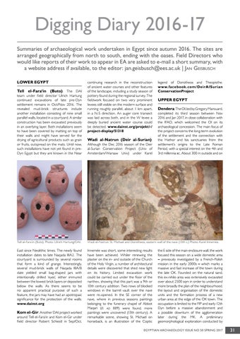
Tell el-Fara‘in (Buto): The DAI team under field director Ulrich Hartung continued excavations of late pre-Dyn settlement remains in Oct/Nov 2016. The revealed mud-brick structures include another installation consisting of nine small parallel walls, located in a courtyard. A similar construction has been excavated previously in an overlying layer. Both installations seem to have been covered by matting on top of their walls and might have served for the drying of agricultural products such as grain or fruits, outspread on the mats. Until now, such installations have not yet found in preDyn Egypt but they are known in the Near
Wadi al-Natrun (Deir al-Surian): Although the Dec 2016 season of the Deir al-Surian Conservation Project (Univ of Amsterdam/Warsaw Univ) under Karel
Tell el-Fara’in (Buto). Photo: Ulrich Hartung/DAI.
Wadi el-Natrun: St. Michael and Dorotheos, eastern wall of the nave (13th c.) Photo: Karel Innemée.
East since Neolithic times. The newly found installation dates to late Naqada IIIA2. The courtyard is surrounded by several rooms that form a kind of grange. Interestingly, several mud-brick walls of Naqada IIIA/B date yielded small bag-shaped jars with intentionally drilled ‘eyes’, either immured between the lowest brick layers or deposited below the walls. As there seems to be no apparent practical purpose of such a feature, the jars may have had an apotropaic significance for the protection of the walls. www.dainst.org
Innemée was short, some interesting results have been achieved. Whiler renewing the plaster on the in- and outside of the Church of the Holy Virgin, a number of architectural details were discovered that shed new light on its history. Limited excavation work could be carried out under the floor of the narthex, showing that this part was a 9th or 10th century addition. Two rows of blocked windows in the barrel vault over the nave were re-opened. In the SE corner of the nave, where in previous seasons paintings belonging to the funerary chapel of Abbot Maqari (d. ad 889) were found, more paintings were uncovered (13th century). A remarkable scene, showing St. Michael on horseback, is an illustration of the Coptic
Kom el-Gir: Another DAI project worked around Tell el-Fara‘in and Kom el-Gir under field director Robert Schiestl in Sep/Oct,
UPPER EGYPT Dendera: The OI, led by Gregory Marouard, completed its third season between Nov 2016 and Jan 2017, in close collaboration with the IFAO, which welcomed the OI on its archaeological concession. The main focus of the project concerns the long-term evolution of the settlement and the connection with the Hathor and Isis sanctuaries from the settlement’s origins to the Late Roman Period, with a special interest on the 4th and 3rd millennia bc. About 300 m outside and on
the E side of the main enclosure wall, the work focused this season on a wide domestic area – previously investigated by a French-Polish mission in the early 2000s – which marks a massive and fast increase of the town during the late OK. Founded on the natural sand, this ex-nihilo area was extensively excavated over about 2500 sqm in order to understand more broadly the plan of the neighbourhood, the layout and organisation of the domestic units and the formation process of a new urban area at the edge of the OK town. The occupation is limited to the FIP and early 12th Dyn before a massive abandonment and a possible downturn of the agglomeration later during the MK. A preliminary geomorphological exploration conducted by
EGYPTIAN ARCHAEOLOGY ISSUE NO 50 SPRING 2017
31