DIGGING DIARY 2016
Missions of the Egypt Exploration Society Merimde Beni Salama and the Wadi el-Gamal: This season comprised two
key areas of work: 1) the Wadi el-Gamal adjacent to Merimde Beni Salama (MBS, and 2) the protective wall and guardians’ building on the registered site of MBS. 1) The Wadi el-Gamal site was examined through test excavation trenches following test pits and geophysical survey in autumn 2015 confirming the presence of sub-surface Neolithic and Middle Palaeolithic finds. A number of excavation trenches were located on the Wadi el-Gamal northwest terraces this spring and they revealed evidence for Neolithic structures via the presence of often mud-lined postholes with ceramics and stones still in place over the mud, also four flexed Neolithic burials, and a large number of refuse pits and hearths close to the surface. In addition a large amount of new evidence came to light for in situ Middle Palaeolithic finds, including, but not exclusively, of Levallois technology, including evidence for tool working. Geological investigations revealed the presence of migrating channels across the site in the Pleistocene. The excavations were greatly aided by a strong presence by the Ministry of Antiquities, our team from Quft led by Rais Omer Farouk, and our local workers. The excavations were funded by the National Geographic Society and the American Research Center in Egypt. 2) The foundation trench for the protective wall was dug along a further two sides of the registered site, and revealed dense occupation deposits in one location, extending out on either side of the wall – this will be investigated in a future season. A concrete foundation was then laid and the low brick wall erected around the site and painted. The on-site building for the guardians was also completed. This has been funded by the American Research Center in Egypt’s Antiquities’ Endowment Fund. www.imbaba.tumblr.com
Tell Mutubis: During the Mar/Apr
season, the geophysical survey of the site under Penelope Wilson (Durham Univ) was completed – a total of 27 hectares of magnetic susceptibility work and three smaller areas using GPR. The preliminary results enabled us to identify several specific events in the life of the site. The S and W sides had suffered much depredation by sebakhin who used light railways to take away
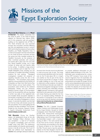
Nabil Abd el-Moniem Osman el-Daleil and Rais Omer Farouk during excavation of a Neolithic posthole on the Wadi el-Gamal northwest terraces.
the earth from the site mound and also lived in small structures built on-site. Two large structures were identified within the mound: one on the N side about 80 m in length and another on the W part of the top of the mound, around 60 m in length. A series of smaller buildings on the N flat area had no distinctive surface evidence, but pottery from the ditches on that side was mostly LR1 amphorae and Egyptian storage jars. Further pottery recording was undertaken including a dipinti (painted monogram), drill augering identified an old waterway to the E of the site and mosaic flooring was noted for the first time in an exposed building. Publication of the results in a monograph is now underway as the survey work has reached a conclusion. www.community.dur.ac.uk/penelope. wilson/Delta/Mutubis.html
to provide additional information on the regional palaeo-landscape of this area. The boreholes were complemented by a series of four ERT transects. Future study of the ceramic fragments from the boreholes will help to clarify the chronology of the deposits encountered and enable the project to link up the various depositional events across the Ay-Horemheb transect. It will also enable us to relate the deposits of to those from the ‘Ramesseum transect’ conducted in 2014-15.
Thebes: Auger site 86 with a Memnon colossus in the background. Photo: THaWS/Angus Graham.
Thebes: The EES / Uppsala University
Theban Harbours and Waterscapes Survey, led by Angus Graham, focused on further investigation of the West Bank floodplain in Jan-Feb 2016. Twenty-three hand-augered boreholes and two percussion cores were drilled along a new 3.2 km-long transect, the ‘Ay-Horemheb transect’, with a maximum spacing of 200 m. The work started close to the front of the Funerary Temple of Ay and Horemheb and extended to the village of Geziret el Bairat on the West Bank of the Nile. The aim was to map the upstream position of the New Kingdom channel that was found in front of the Ramesseum and EGYPTIAN ARCHAEOLOGY ISSUE NO 49 AUTUMN 2016
37