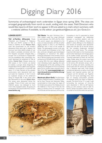
Digging Diary 2016 Summaries of archaeological work undertaken in Egypt since spring 2016. The sites are arranged geographically from north to south, ending with the oases. Field Directors who would like reports of their work to appear in EA are asked to e-mail a short summary, with a website address if available, to the editor: jan.geisbusch@ees.ac.uk | Jan Geisbusch LOWER EGYPT Tell el-Farkha (Ghazala): Marek Chlodnicki and Krzysztof M. Cialowicz of IAJU and PCMA worked at Tell elFarkha in Feb/Mar. At the Western Kom, work still concentrated on the brewery discovered three years ago. It appears the structure had three distinct phases of use: the oldest is probably connected with the first Naqadan occupation (Naqada IID), a younger one is connected to Naqada IIIA1 and was established after catastrophic fire, which destroyed the settlement at Tell elFarkha. Central Kom: Already during the 2016 season, in the S trench, we started to explore a younger phase (beginning of Naqada IID) of the so-called Lower Egyptian ‘residence’, surrounded by a mud-brick wall about 1.2 m thick. Remains of the wooden constructions were discovered both outand inside the ‘residence’. In the N trench we explored remains of the settlement dating to Naqada IIIB. A few graves were also discovered on this area. Eastern Kom: Five graves were discovered during the campaign. Three of them were very poor childrens’ graves, two belonged to much more richly equipped adults. All graves are connected to the second half of the 1st Dyn. www.farkha.org
Tell Basta: The joint Würzburg Univ / MSA mission under Eva Lange continued its work between Oct 2015 and Mar 2016. The autumn season was dedicated to the study and documentation of finds of earlier digging seasons in Area A, the Ptolemaic settlement site in front of the temple of Bastet. The geomagnetic survey in the area of the ancient city of Bubastis at the E Tell also continued, alongside geomorphological investigations to reconstruct the palaeolandscape of Bubastis. In the cemetery area at the N Tell the ongoing documentation of the architecture of the elite tombs was resumed. In spring 2016 first core drillings delivered most interesting results regarding the early hydrogeography of the site, pointing to the existing of an elongated, N-W to S-E oriented gezira and an ancient water channel at the N side of the Tell. www.aegyptologie.uniwuerzburg.de/wissenschaftforschung/ tell_basta_project Naukratis (Kom Geif): The fifth British
Museum fieldwork season in April/May 2016, led by Ross Thomas and Alexandra Villing, concentrated on three areas: the region of the Greek sanctuaries of the Dioskouroi and the Hellenion in the N part of the site, the silted up remains of the LP riverbank in the W of the site and the sanctuary of Amun-Ra.
Tell el-Farkha: remains of the brewery. Photo: IAJU / PCMA
34
Excavations in the N, supervised by Astrid Lindenlauf, investigated the relationship between a mud-brick platform with the W gateway to the Hellenion. Around the platform votive offerings to the Dioskouroi and remains of sacrifices were discovered, dating from the late 7th to the 6th century BC and including Greek-style inscribed pottery and animal bones. This provides important information on the ritual practices, construction techniques and changing layout of the earliest Greek sanctuaries in Egypt. Trenches supervised by Edwin de Vries and Ashley Pooley along the ancient river bank yielded sequences of early 3rd century BC to 6th century BC domestic dumps, with a series of surfaces and banks, including one constructed with 5th century BC amphorae over a flattened reed bank. Finds include architectural elements as well as much local Egyptian and imported pottery, both for transport and for domestic use. Together with the rich faunal assemblage they shed light on changing consumption practices at Naukratis during the Saite to Ptolemaic periods. The limits of the 17 m wide S wall surrounding the sanctuary of Amun-Ra were discovered in 2016 by Jeff Spencer, linking up with previous work on Saite to Roman period occupation within this area. A number of structures within the sanctuary
Athribis: Hathor capital. Photo: Athribis Project.