UNDERSTANDING POTTERY AND PEOPLE AT THE AMARNA STONE VILLAGE
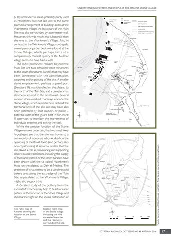
Top right: map of Amarna showing the location of the Stone Village.
Maps by Barry Kemp and Helen Fenwick, modified by Anna Stevens, courtesy of the Amarna Project.
p. 18) and external areas, probably partly used as residences, but not laid out in the same planned arrangement of buildings seen at the Workmen’s Village. At least part of the Main Site was also surrounded by a perimeter wall. However, this was much less substantial than the one at the Workmen’s Village. Also in contrast to the Workmen’s Village, no chapels, animal pens or garden beds were found at the Stone Village, which perhaps hints at a comparatively modest quality of life. Neither village seems to have had a well. The most prominent remains beyond the Main Site are two denuded stone structures to the south (Structures I and II) that may have been connected with the administration, supplying and/or policing of the site. A smaller stone emplacement, perhaps a guard post (Structure III), was identified on the plateau to the north of the Main Site, and a cemetery has also been located to the south-east. Several ancient stone-marked roadways encircle the Stone Village, which seem to have defined the territorial limit of the site and may have also been patrolled by foot soldiers or police – potential users of the ‘guard post’ in Structure III (perhaps to monitor the movements of individuals entering and exiting the site). While the precise function of the Stone Village remains uncertain, the two most likely hypotheses are that the site was home to a community of labourers who worked on the quarrying of the Royal Tomb (and perhaps also non-royal tombs) at Amarna, and/or that the site played a role in provisioning and supporting desert-based workforces, including the supply of food and water. For the latter, parallels have been drawn with the so-called ‘Workmen’s Huts’ on the plateau at Deir el-Medina. The presence of what seems to be a concentrated bakery area along the east edge of the Main Site, unparalleled at the Workmen’s Village, might also support this. A detailed study of the pottery from the excavated trenches may help to build a clearer picture of the function of the Stone Village and shed further light on the spatial distribution of
Bottom right: map of the Stone Village indicating the nine excavated trenches and the roadways surrounding the site. EGYPTIAN ARCHAEOLOGY ISSUE NO 49 AUTUMN 2016
17