EGYPTIAN
ARCHAEOLOGY
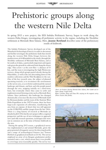
Prehistoric groups along the western Nile Delta In spring 2013 a new project, the EES Imbaba Prehistoric Survey, began to work along the western Delta fringes, investigating all prehistoric activity in the region, including the Neolithic settlement at Merimde Beni Salama. Here, Joanne Rowland describes some of the preliminary results of fieldwork. The Imbaba Prehistoric Survey developed out of the Minufiyeh Archaeological Survey in order to document and further investigate the prehistoric finds that stretch along the western Nile Delta fringes between the modern town of el-Khatatbah in the north, through the Neolithic settlement of Merimde Beni Salama, and as far south as el-Qata, a particularly important and urgent task given the growth in cultivated land along the desert edge. This covers – as the crow flies – a distance of 15 km, and the team is investigating the high Pleistocene terraces, along which groups passed already during the Palaeolithic, as well as the area descending down to the modern cultivation and the Nile floodplain to the east. One of the key research aims, the subject of planned upcoming research, is to reconstruct the environment in the survey area, so as to better understand the natural landscape and climate, and how and why people passed through the area, stopping initially on a short-term basis, but eventually where they came to settle and implement mixed farming at sites such as Merimde Beni Salama. Since prehistory, this landscape has changed dramatically; even since the discovery of Merimde itself by Hermann Junker and the team of the Austrian West Delta Expedition in the 1927-8 season, there has been large-scale expansion of cultivation, transforming the area from an expanse of desert that was still apparent on the CORONA satellite images from the late 1960s. There is a long history of research at Merimde (as detailed in JEA 100), but the new project offers a regional perspective and the use of new techniques to approach new (and old) research questions, techniques that were not in common use at the time of former fieldwork in the area. During the spring 2013 season, a geophysical survey was implemented at and around Merimde, given the great potential of magnetic survey for detecting hearths and a range of archaeological features (see Tomasz Herbich on geophysical methods in EA 41). The survey employed an array of six fluxgate gradiometer probes mounted onto a cart, which meant that it was possible to cover large areas reasonably quickly. The survey was
Above: site locations showing Merimde Beni Salama, Abu Ghalib and elQatta. (Image: Google Earth). Below: Cornelius Meyer and Dana Pilz carrying out the magnetic survey. (Photo: Eastern Atlas, Berlin)
37