EGYPTIAN
ARCHAEOLOGY
Reflectance Transformation Imaging The popularisation of digital photography and computers has led to the development of new types of documentation, as well as the emergence of new ways of data collecting. One such new method is Reflectance Transformation Imaging (RTI). It creates an interactive image from a set of photos taken with a stationary camera. Each photo is different from the other only by the direction of illumination. A special software then mathematically recreates the surface of the scene from the recorded variations of light and shadow. When opened in ‘RTIViewer’, we are able to manipulate the lighting of the scene, helping to reveal characteristics of the examined object that might be poorly visible or even invisible to the naked eye. Using this method at Gebelein led to the discovery of an image of the god Min. It also allowed us to detect new elements of prehistoric graffiti, normally invisible due to their poor state of preservation and untraceable by more traditional forms of documentation. Simple digital photos combined with specialised software also allow us to generate new information. At Gebelein, one software programme used in image processing is the ‘Decorrelation Stretch’ (see also Roland Enmarch’s article on the next page), which reinforces the colour differences between pixels. The use of this software on selected photographs taken during the last season led to the discovery of new, previously unseen, hieroglyphic inscription. Piotr Witkowski
Mobile GIS and satellite imagery analysis in field survey During our reconnaissance at Gebelein we used mobile Global Navigation Satellite System (GNSS) tools with geographic information system (GIS) applications to document positions and detailed information of the discovered features. We used Trimble Juno, MobileMapper 20 and ArcPad-ArcGIS applications, which allowed us to create a database of the features found in the field. Additionally, we combined the positions of the features with further information, such as its state of conservation (endangered, destroyed) or the kind of material it contained (if any). We also connected these data with photographs of the archaeological remains. Before approaching the field, we used GIS to analyse archival maps and contemporary satellite imagery. Comparing Pierre Jacotin’s map, created during the Napoleonic expedition to Egypt (1798-1801), with Corona, Landstat and Google satellite images from 1969, 1974 and 2013 respectively, the agricultural spread became apparent. Agricultural growth has already partly destroyed one of the palaeolithic sites, while one of the ancient cemetries has been bulldozed. The use of infrared satellite images also allowed us to spot several vegetation marks in the area. We have used mobile GIS to verify those features during the field survey, and we hope to continue this work in the coming seasons. Julia Chyla
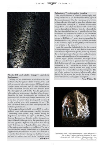
Opposite page: Dawid F.Wieczorek documenting a graffito of Ramesses IV. Top left: face of Hathor – detail of the decoration of the speos. Above right: Julia Chyla and Cezary Baka documenting a tomb. (Photos:Wojciech Ejsmond) 9