EGYPTIAN
ARCHAEOLOGY
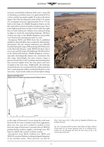
terraced, and fortified settlement built onto a steep hill overlooking an amethyst mine; it is approximately 80 m x 60 m, and the top stands roughly 20 m above the desert surface. Site 9 lies one kilometre south of Site 5. It consists of a rectangular structure (approximately 50 m x 72 m) built in the shape of a Middle Kingdom fortress on the flat wadi surface in front of another amethyst mine. Site 6 is the highest peak between Sites 5 and 9 with clear sight lines to both settlements. Soldiers were stationed along its ridges to watch the surrounding landscape. All three of these sites date to the Middle Kingdom and possibly even functioned contemporaneously as a unit. Inscriptions WH3 and WH4 from Site 5, published initially by Ahmed Fakhry, then reedited by Ashraf Sadek, demonstrate that the mining settlement was officially founded during the reign of Montuhotep (IV) Nebtawyre in the Eleventh Dynasty, while WH22-25 show that it was in use until the reign of Sobekhotep (IV) Khaneferre in the Thirteenth Dynasty. Middle Kingdom ceramics, especially chronologically distinct zirs, corroborate this date range. Interestingly, the same ceramic corpus is present at both Sites 5 and 9, perhaps demonstrating that they received supplies from the same places and were occupied at the same time. Additionally, the landscape around both sites was monitored by the soldiers posted at Site 6, indicating that soldiers watched both places at the same time. A previously undiscovered inscription dating
to the reign of Senwosret I occurs along the wadi route between the two sites. Contrary to previous suggestions, these two sites may have worked in tandem at least from the reign of Senwosret I onwards (also see WH14), perhaps sharing workers, supplies, and storage areas. We hope to explore this scenario in future seasons. Inscriptions from Wadi el-Hudi (viz. WH4 and WH143) mention Nubians working alongside Egyptians at the amethyst mines. Their presence can also be
Above: sketch map of Site 9. (Plan of fort by Magdalena Wlodarska, map by Bryan Kraemer.) Top: Site 5 inscription WH59 of Smsw Nmty-anxw (sA) Inpw, Follower Nemty-Ankh (son of) Anubis, appearing inside of an individual house. Looking west, the photograph also shows the lower terrace of Site 5, the exterior wall, and the mine.
38