EGYPTIAN
ARCHAEOLOGY
Geomorphological and geophysical survey In view of the enormous dimensions of the Temple of Heliopolis (1,100 x 900 m) and the limited chance for excavations due to the high groundwater table, a geomorphological and geophysical survey was carried out by the joint Egyptian-German Archaeological Mission in Matariya, report Morgan De Dapper and Tomasz Herbich. The combined investigations began within the circular structure that was known in the past as ‘fort bank of the Hyksos Period’ or as the ‘High Sand of Heliopolis’. By hand drillings, a stratigraphy of 4th and 3rd millennium bc was discovered 300 m west of the obelisk.The pottery of the earliest occupation 10 m deep shares characteristics of the Buto-Maadi culture. It is located on top of a late Pleistocene sandy gezira. Another set of drillings was made in Area 210. It provided evidence for the extension of the same gezira.
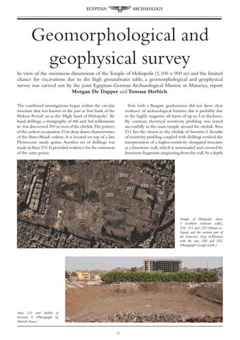
Tests with a fluxgate gradiometer did not show clear evidence of archaeological features; this is probably due to the highly magnetic silt layers of up to 3 m thickness. By contrast, electrical resistivity profiling was tested successfully in the main temple around the obelisk. Area 211 lies the closest to the obelisk of Sesostris I. Results of resistivity profiling coupled with drillings verified the interpretation of a higher-resistivity elongated structure as a limestone wall, which is surrounded and covered by limestone fragments originating from the wall.At a depth
Temple of Heliopolis: Areas 5 (southern enclosure walls), 210, 211 and 220 (Misraa esSegun) and the western part of the temenos (Suq el-Khamis) with the sites 200 and 202. (Photograph: Google Earth.)
Area 211 and obelisk of Sesostris I. (Photograph by Dietrich Raue.) 12