EGYPTIAN
ARCHAEOLOGY
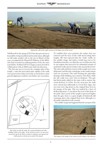
Defining the walls of the temple sanctuary at the highest point of the mound
To establish their exact positions the surface dust was removed and the faces of the walls traced along their lengths. We had expected that the ‘walls’ visible on the satellite image and surface would turn out to be foundation-trenches, as is often the case on Delta sites, but to our surprise they proved to be substantial remains of mud-brick walls, preserved above the ancient floor level. The side walls and front corners of the temple were soon delineated, and then the central gate in the south-eastern wall was excavated. This wall, forming the pylon-like frontage of the building, was a massive 10m thick, while the side walls were each 4.5m in thickness. The gate had brick jambs added to the main wall to narrow the actual doorway to 3.05m. For the most part, the walls were cleared just sufficiently to reveal their edges, but two tests were dug down to the original floor level in the passage of the gate. This was marked by a layer of broken limestone c.1.1m below the level of the front of the jamb. Since much of the temple is preserved higher than the gate, there is a great height of brickwork still remaining above this original floor level, although it is all totally embedded in the mound. The satellite image had suggested that the rear part of the
Tell Buweib in the spring of 2013 but that proved not to be possible owing to political and security issues, although we did make another visit to the site in March of that year, accompanied by Elsayed El-Talhawy of the MSA, who had excavated an outlying portion of the site some years before. In March 2014 we began a season of work in collaboration with an MSA team under his direction. The first aim was to recover the complete plan of the temple, a task that proceeded quite rapidly as the walls were preserved to surface level and, as noted above, their general alignment could be seen before any excavation.
eib uw ll B
in
Dra
Te
21
16
6
22
17
1
12
7
18
23
13
2
8
19
14
24
9
3
20
15
10
4
11
5
N
Area tested by MSA
100m
Plan of the site with the temple, the casemate foundation and other buildings visible on the surface. At the south-west corner is an area tested several years ago by the MSA in which no antiquities were reported and which may be on the line of an ancient Nile channel
The entrance to the temple in the south-east wall, looking to the north-west