EGYPTIAN
ARCHAEOLOGY
A New Kingdom temple in the Delta In spring 2014 the EES Delta Survey, in collaboration with a team from the Egyptian Ministry of State for Antiquities, began to investigate the little-known site of Tell Buweib in the north-east Nile Delta. Jeffrey and Patricia Spencer summarise the results of the EES fieldwork.
The mound at Tell Buweib viewed from the south. The highest part has built up around and over the New Kingdom temple
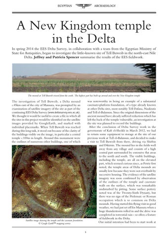
was noteworthy in being an example of a substantial casemate-platform foundation, of a type already known at other Delta sites, most notably Tell Dafana, Naukratis and Tell el-Balamun. Since the original dimensions of the ancient mound have already suffered reduction which has left the back of the temple vulnerable, an investigation at the site was planned to record the buildings. After the conclusion of Delta Survey work in the governorate of Kafr el-Sheikh in March 2012, we had to return some equipment to storage at the site of our previous work at Tell el-Balamun, and decided to make a visit to Tell Buweib from there, driving via Shirbin and Dikirnis. The mound lies in the fields well away from any village and consists of a high central part surrounded by extensive flat areas to the north and south. The visible buildings, including the temple, are all on the elevated part, which seemed curious since, as Petrie first noted, the temple areas of Delta mounds are usually low because they were not overbuilt by successive housing. The evidence of the satellite imagery was soon confirmed by observation of the outlines of the temple and casemate walls on the surface, which was remarkably undisturbed by pitting. Some surface pottery noted was of the Twenty-Sixth Dynasty, but there was no sign of the Ptolemaic or Roman occupation which is so common on Delta mounds. Having started this flying visit in good weather, we had just set off for Mansura when a huge thunderstorm rolled in and the drive was completed in torrential rain - so often a feature of fieldwork in the Delta. Our initial intention had been to start work at
The investigation of Tell Buweib, a Delta mound c.45km east of the city of Mansura, was prompted by an examination of satellite imagery of the site as part of the continuing EES Delta Survey (www.deltasurvey.ees.ac.uk). We thought it would be useful to create a file in which all the sites in this project would be identified on the satellite images provided by GoogleEarth, and marked with individual placemarks. When Tell Buweib was reached during this long task, it stood out because of the clarity of the buildings visible on the image, in particular a central temple c.100m in length. Around this monument were the outlines of numerous other buildings, one of which
Satellite image showing the temple and the casemate foundation. Š Google Earth™ mapping service