EGYPTIAN
ARCHAEOLOGY
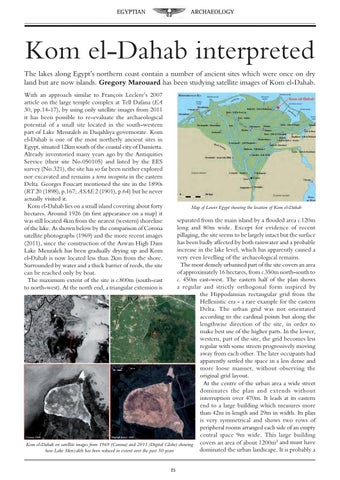
Kom el-Dahab interpreted The lakes along Egypt’s northern coast contain a number of ancient sites which were once on dry land but are now islands. Gregory Marouard has been studying satellite images of Kom el-Dahab. With an approach similar to François Leclere’s 2007 article on the large temple complex at Tell Dafana (EA 30, pp.14-17), by using only satellite images from 2011 it has been possible to re-evaluate the archaeological potential of a small site located in the south-western part of Lake Menzaleh in Daqahliya governorate. Kom el-Dahab is one of the most northerly ancient sites in Egypt, situated 12km south of the coastal city of Damietta. Already inventoried many years ago by the Antiquities Service (their site No.050105) and listed by the EES survey (No.321), the site has so far been neither explored nor excavated and remains a terra incognita in the eastern Delta. Georges Foucart mentioned the site in the 1890s (RT 20 (1898), p.167; ASAE 2 (1901), p.64) but he never actually visited it. Kom el-Dahab lies on a small island covering about forty hectares. Around 1926 (its first appearance on a map) it was still located 4km from the nearest (western) shoreline of the lake. As shown below by the comparison of Corona satellite photographs (1969) and the more recent images (2011), since the construction of the Aswan High Dam Lake Menzaleh has been gradually drying up and Kom el-Dahab is now located less than 2km from the shore. Surrounded by water and a thick barrier of reeds, the site can be reached only by boat. The maximum extent of the site is c.800m (south-east to north-west). At the north end, a triangular extension is
Map of Lower Egypt showing the location of Kom el-Dahab
separated from the main island by a flooded area c.120m long and 80m wide. Except for evidence of recent pillaging, the site seems to be largely intact but the surface has been badly affected by both rainwater and a probable increase in the lake level, which has apparently caused a very even levelling of the archaeological remains. The most densely urbanised part of the site covers an area of approximately 16 hectares, from c.350m north-south to c. 450m east-west. The eastern half of the plan shows a regular and strictly orthogonal form inspired by the Hippodamian rectangular grid from the Hellenistic era - a rare example for the eastern Delta. The urban grid was not orientated according to the cardinal points but along the lengthwise direction of the site, in order to make best use of the higher parts. In the lower, western, part of the site, the grid becomes less regular with some streets progressively moving away from each other. The later occupants had apparently settled the space in a less dense and more loose manner, without observing the original grid layout. At the centre of the urban area a wide street dominates the plan and extends without interruption over 470m. It leads at its eastern end to a large building which measures more than 42m in length and 29m in width. Its plan is very symmetrical and shows two rows of peripheral rooms arranged each side of an empty central space 9m wide. This large building 2 Kom el-Dahab on satellite images from 1969 (Corona) and 2011 (Digital Globe) showing covers an area of about 1200m and must have dominated the urban landscape. It is probably a how Lake Menzaleh has been reduced in extent over the past 50 years 25