EGYPTIAN
ARCHAEOLOGY
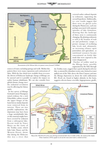
covered earlier cultural deposits in sediments, supporting the second hypothesis. Additionally, ice core results suggest that there were six glacial cycles during the Pleistocene, each one perhaps associated with separate episodes of lake formation, showing that the landscape of these areas is continuously changing. By plotting sediments as well as the location of rock art and prehistoric camps, a picture emerges of oscillating lake levels and, ultimately, an increasing reliance upon pastoralism and agriculture, as nutritional resources became concentrated on fertile lake muds that were exposed as the water disappeared. Patches of redder mud in the Kharga basin, possibly Reconstruction of the Holocene lake at its greatest extent of around 3,000km2 augmented by the Nile through sources of water, including springs and wells. Within this the Toshka route, suggest that a quick drying bio-diverse pattern there were many expansions and contractions of lake, as attested by abundant worm casts, formed as water lakes. With the fine detail now available from ice-cores spilled out of the Nile above the First Cataract and into the drivers of Holocene landscape change at Kharga can the Kharga depression in about the sixth millennium be assessed and it is possible to explore the impact on BC. Rock art, found at higher altitudes in the basin, earlier human inhabitants. We can also consider how suggests a diverse fauna: crocodile, hippopotamus, giraffe, global climate change since the industrial revolution may be affecting the Sahara again. In her survey of Kharga Gertrude Caton-Thompson noted evidence for a rich Palaeolithic culture around the upper fringes of the basin but no similar deposits were retrieved from its interior. There are two possible explanations: the depression may have been a huge uninhabitable lake or this material might have been covered by sediment from a subsequent lake. Recent work by Vance Hayes on the route of the Toshka canal, which links Lake Nasser and the Western Desert, shows that during the Holocene Map of the NKODAAS survey area showing reconstructed lake areas in shades of blue, the outcrop of the Surface this was a river that Water Sandstone (SWS) aquifer in red and the main desert tracks as dashed red lines 10