EGYPTIAN
ARCHAEOLOGY
Kharga Oasis: a Saharan patchwork of lakes Today the Sahara forms one of the world’s largest deserts, with the exception of a few oases, and is a significant barrier to human and animal migration. Judith Bunbury and Salima Ikram reveal how during the Holocene the climate and environment were quite different.
Although the area around Fish Rock in Kharga Oasis is barren today, it is a rich source of lithic finds and rock art, including depictions of fish and a crocodile
The North Kharga Oasis Darb Ain Amur Survey (NKODAAS) has been recording hitherto unknown sites in the north-western part of the Kharga basin since 2004 and has found that in the past large lakes and damp patches periodically fostered settlement of the area. Access to high-resolution satellite photography and topographic data has transformed research in remote areas since many of the sites we are investigating can now be seen from space, and additional sites can be identified for potential exploration. Combined with digital elevation models, these images are a powerful tool for modelling past landscapes, including lakes and aquifers. Many researchers, including Nick Drake, Fred Wendorf, Romuald Schild and Simon Armitage, have studied the playas (dried-up lakes) of the Sahara and established that the surrounding areas were episodically inhabited as water levels rose and fell; Kharga is no exception. Our work shows that historically four main sources of water supplied Kharga: overflow from the Nile which formed lakes in the Kharga basin; artesian water as today; direct rainfall; and springs fed by local aquifers which could sustain lakes for longer than in the deep Sahara. Analysis of sediments from the depression shows how the lakes waxed and waned over time. As recently as the Neolithic and in Dynastic times lakes persisted here and at its greatest extent the Khargan lake that formed the basin measured up to
3,000km2 and supported a diverse flora and fauna. Changes in rainfall are driven by global climate cycles. At the end of the last glaciation, around 10,000 years ago, global temperatures first rose to levels above those we experience now, causing increased local rainfall in north Africa and an intensified monsoon in the Ethiopian Highlands, augmenting the Blue Nile. As lakes formed, human exploitation of the areas re-intensified. Then, as global Holocene temperatures dropped, water became sparse and lake levels fell. Communities moved into the fertile lakebeds, concentrated around the remaining
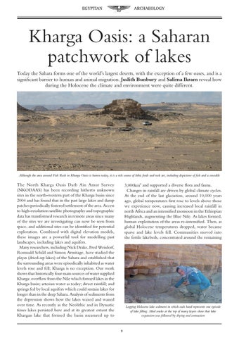
Logging Holocene lake sediment in which each band represents one episode of lake filling. Mud cracks at the top of many layers show that lake expansion was followed by drying and contraction