EGYPTIAN
ARCHAEOLOGY
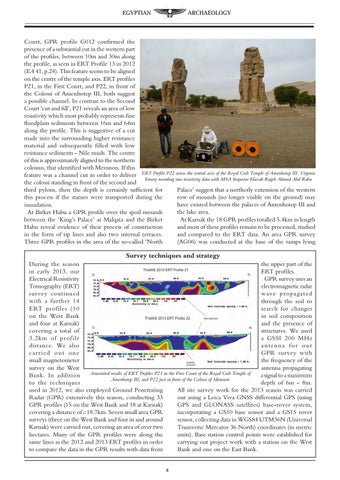
Court, GPR profile G012 confirmed the presence of a substantial cut in the western part of the profiles, between 10m and 30m along the profile, as seen in ERT Profile 13 in 2012 (EA 41, p.24). This feature seems to be aligned on the centre of the temple axis. ERT profiles P21, in the First Court, and P22, in front of the Colossi of Amenhotep III, both suggest a possible channel. In contrast to the Second Court ‘cut and fill’, P21 reveals an area of low resistivity which most probably represents fine floodplain sediments between 16m and 64m along the profile. This is suggestive of a cut made into the surrounding higher resistance material and subsequently filled with low resistance sediments - Nile muds. The centre of this is approximately aligned to the northern colossus, that identified with Memnon. If this feature was a channel cut in order to deliver ERT Profile P22 across the central axis of the Royal Cult Temple of Amenhotep III. Virginia Emery recording raw resistivity data with MSA Inspector Elazab Rageb Ahmed Abd Rabu the colossi standing in front of the second and Palace’ suggest that a northerly extension of the western third pylons, then the depth is certainly sufficient for row of mounds (no longer visible on the ground) may this process if the statues were transported during the have existed between the palaces of Amenhotep III and inundation. the lake area. At Birket Habu a GPR profile over the spoil mounds At Karnak the 18 GPR profiles totalled 5.4km in length between the ‘King’s Palace’ at Malqata and the Birket and most of these profiles remain to be processed, studied Habu reveal evidence of their process of construction and compared to the ERT data. An area GPR survey in the form of tip lines and also two internal terraces. (AG06) was conducted at the base of the ramps lying Three GPR profiles in the area of the so-called ‘North
Survey techniques and strategy During the season the upper part of the in early 2013, our ERT profiles. Electrical Resistivity GPR survey uses an Tomography (ERT) electromagnetic radar survey continued wave propagated with a further 14 through the soil to ERT profiles (10 search for changes on the West Bank in soil composition and four at Karnak) and the presence of covering a total of structures. We used 3.2km of profile a GSSI 200 MHz distance. We also antenna for our carried out one GPR survey with small magnetometer the frequency of the survey on the West antenna propagating Annotated results of ERT Profiles P21 in the First Court of the Royal Cult Temple of Bank. In addition a signal to a maximum Amenhotep III, and P22 just in front of the Colossi of Memnon to the techniques depth of 6m - 8m. used in 2012, we also employed Ground Penetrating All site survey work for the 2013 season was carried Radar (GPR) extensively this season, conducting 33 out using a Leica Viva GNSS differential GPS (using GPR profiles (15 on the West Bank and 18 at Karnak) GPS and GLONASS satellites) base-rover system, covering a distance of c.18.7km. Seven small area GPR incorporating a GS10 base sensor and a GS15 rover surveys (three on the West Bank and four in and around sensor, collecting data in WGS84 UTM36N (Universal Karnak) were carried out, covering an area of over two Transverse Mercator 36 North) coordinates (in metric hectares. Many of the GPR profiles were along the units). Base station control points were established for same lines as the 2012 and 2013 ERT profiles in order carrying out project work with a station on the West to compare the data in the GPR results with data from Bank and one on the East Bank.