EGYPTIAN
ARCHAEOLOGY
Plinthine on Lake Mareotis In 2013 fieldwork at Kom el-Nugus (Plinthine) on Lake Mareotis focused on a large mound overlooking the ancient town. Sylvain Dhennin and Bérangère Redon describe this settlement with archaic and classical Greek imports, raising questions about the history and nature of the site.
10km
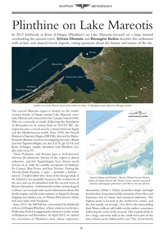
Satellite view of the Mareotis region of the north-west Delta. © BingMaps image adapted by Bérangère Redon
The ancient Mareotis region is located on the northwestern border of Egypt around Lake Mareotis (now Lake Mariut) and connected to the Canopic branch of the Nile via a network of canals. Following the foundation of Alexandria on its eastern limit in 332/331 BC, the region became a crucial area for contacts between Egypt and the Mediterranean world. Since 1998, the French Mission toTaposiris Magna (MFTM), directed by MarieFrançoise Boussac, has been investigating two sites: Abusir (ancient Taposiris Magna, see also EA 33, pp.12-14) and Kom el-Nugus, usually identified with Plinthine (see also inset on p.37). Their Ptolemaic and Roman past is well-attested, whereas the pharaonic history of the region is almost unknown, and few Egyptologists have shown much interest in it, with the notable exceptions of Anthony De Cosson, Alan Rowe and Jean Yoyotte. During the Twenty-Sixth Dynasty, a ‘gate’ - probably a fortress named a3-n-ḫ3zt-THnw (the ‘door of the foreign lands of the Libyans’) was probably located in the north-west of the area and can be identified with the ancient town of Khaset-Tjemehou. Unfortunately neither archaeological evidence nor texts provide much information about this border region, and the main entrance to Egypt for foreign shipping was further east, at Thonis (Heracleion) which had close links with Naukratis. Since 2012 the MFTM has concentrated its fieldwork at Kom el-Nugus/Plinthine, whose existence in the preHellenistic Period is suggested by references in the works of Hellanicus and Herodotus. In April 2013, we started the excavation of Plinthine’s kom, whose impressive
Taposiris Magna and Plinthine. Plan by Thibaud Fournet (Institut français du Proche-Orient) with Thomas Arnoux (Institut national de recherches archéologiques préventives) and Olivier Onézime (IFAO)
dimensions (180m x 150m), horseshoe-shape and high location have long attracted the attention of travellers and historians, but its nature had remained unknown. The highest point is located at the north-west corner, and the kom stands, on average, 11m above the surrounding land. Many walls are still visible on the surface, sometimes following the crests of the mound. This is particularly so for a huge east-west wall in the south-west part of the kom, which can be followed for over 75m. A test trench 36