EGYPTIAN
focused on the El-Hassan Reef, 500m E of the tip of the Silsileh Promontory. This reef, first represented as a shoal on the 1472 map of Alexandria in the Codex Urbinate 277, is now submerged with its top at a depth of 12m and its contours at 17m. The subsidence is certainly due to a natural phenomenen which is being investigated. The remains of a shipwrecked cargo of amphorae was found at a depth of 14m while an iron anchor, probably from a merchantman, was traced at 17m depth. The scattered cargo of broken amphorae as well as the type of iron anchor present suggests a date in the Late Roman/Early Byzantine Period (fourth-seventh centuries. AD). A frame timber of the ship and the iron anchor were raised for conservation. An Islamic Period (elevenththirteenth centuries AD) stone anchor was also found on the reef. Buto: 1. The DAI team, directed by Ulrich Hartung, continued work on the EDP structures N of the village of Sekhmawy. Three main occupation phases can be distinguished - from the beginning of the 1st Dyn until the middle of the 2nd Dyn - illustrating the development of an official estate, probably with economic and administrative functions. During the second half of the 1st Dyn the existing structures were replaced by a newly built palace-like building complex with rooms, magazines and workshops. The entrance (or one of the entrances) of the complex was found near its NW corner and connected to the large central reception room by an angled corridor. 2. The Univ of Poitiers team, led by Pascale Ballet and supported by the French Ministry of Foreign and European Affairs, IFAO and the Centre of Alexandrian Studies, continued the investigations of the late history of the site by field-walking and geophysical surveys as well as test trenches on the N kom (Kom A) of Buto. Naukratis: The BM Team, directed by Ross Thomas, continued the programme of magnetometry, with 15ha of the site now covered, including both central and more outlying areas. This enabled us to get a better understanding of the likely extent of the ancient site: the settlement (excluding the cemetery) covered at least 52ha. The magnetometry results revealed a large number of structures within the area of the Egyptian sanctuary (the ‘Great Temenos’), in the dried-up lake and to the N and E of the site. Excavations conducted by Penny Wilson focused on key above-surface structures on the ‘South Mound’. The results of a programme of drill coring, conducted by Ben Pennington, suggest the presence of a river channel located to the W of the site: the Canopic branch of the Nile. www.britishmuseum.org/research/research_projects/
ARCHAEOLOGY
within the Univ of Hawaii’s concession) took place under the direction of Katherine Blouin. The area excavated is in the NE part of the tell, in what Daressy called the ‘Khoronfich’. Attention focused on some clusters of red-brick jointed with lime mortar that were protruding from the surface. The scarcity of finds and the depth of the stratigraphic features, which were exclusively made of deposits and modern fills, soon indicated that the area had already been excavated. As a result, neither the foundation nor the abandonment dates of the structure are known, but the bricks and the masonry technique indicate a Late Roman date. The structure consists of a rectangular room standing more than 3m high and c.15m long, prolonged in the NW by an apse, which has a bay in its axis and opens into a small apse in the SW. The latter was covered with a quarter-sphere vault. The building typology seems to indicate that the structure belongs to a much larger ensemble. Late Hellenistic pottery was found beneath the foundation level of the larger apse, in undisturbed contexts. In parallel to the excavations, an intensive field survey of the adjacent parts of the tell was undertaken. www.utsc.utoronto.ca/~kblouin/MCT. html
Tell el-Daba (Avaris): The work of the Austrian Archaeological Inst, directed by Irene ForstnerMüller, started work in a new area R/IV, where the main harbour of Avaris was assumed to be located. The area was occupied in the later SIP when a row of large tombs, unfortunately heavily robbed, was aligned with an earlier massive sandbrick wall. There is no evidence for occupation during the 18th Dyn but it was occupied again in the Ramesside Period. Work within the socalled palace in area F/II continued with the focus on the central courtyard of its SW area. Within the courtyard several mud floors could be discerned, on top of which, and partly cutting through them, were dense layers of archaeological remains consisting of later 15th Dyn pottery, seal impressions, stone tools and other stone fragments: probably the rubbish of the palace left after its abandonment. To the W remains of the court’s mud-brick enclosure wall were excavated, but it had been badly damaged by later activities. To the SW of the central back courtyard no architectural remains or floor levels were visible - it may have been an open space in antiquity. The impression of a small fallen tree was visible on the surface but there were no organic traces left. A pit with a bovid skeleton was cut into the enclosure wall.
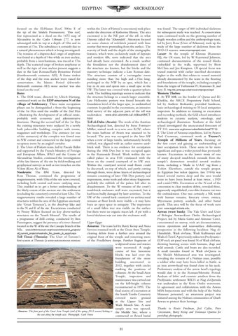
Upper Egypt Amarna: The team led by Barry Kemp and Anna Stevens resumed work at the Great Aten Temple, all_current_projects/naukratis_the_greeks_in_egypt.aspx clearing debris from a further area around the Tell Timai (Thmuis): The Univ of Toronto’s original front of the temple and removing more first season at Thmuis (a semi-autonomous mission of the Pendlebury dumps. Further fragments of sculptured stone and statues were recovered. A single course of fine limestone blocks was laid over the foundations of the stone building uncovered in 2012, together with circles marking the positions of columns. At the Small Aten Temple, inspection and maintenance was carried out on the full-height column reconstructed in 1995. The final season of excavation at the South Tombs Cemetery covered more ground at the Upper Site and Wadi Mouth Site. A new sample area was opened, Amarna: The front part of the Great Aten Temple (end of the spring 2013 season) looking to the Middle Site, where a the east along the temple axis. Photograph: Gwil Owen contracted or flexed burial
31
was found. The target of 400 individual skeletons for subsequent study was reached. A conservation team continued work on the growing number of fragile wooden coffins and the anthropology team, led by Jerry Rose (Univ of Arkansas), took up the study of the large number of skeletons from the 2012-13 seasons. www.amarnaproject.com Luxor: At the temple of Khonsu (Ramesses III), the OI team, led by W Raymond Johnson, continued documentation of the reused blocks embedded in the walls, supervised by Brett McClain and Jen Kimpton. Of special focus was reused material with earlier inscribed decoration higher in the walls that relates to reused material already documented by the team in the flooring and foundations of the temple, including examples from the reigns of Tuthmosis IV, Ramesses II, and Sety II. http://oi.uchicago.edu/research/projects/epi/ Western Thebes: 1. At TT 110, on the border of Qurna and ElKhokha, the ARCE Preparatory Field School, led by Andrew Bednarski, provided hands-on, basic archaeological training to 35 local antiquities inspectors. In addition to training in excavation and recording methods, the field school introduces students to ceramic analysis, osteology, and archaeological illustration. Students at the field school investigated the unexcavated forecourt of TT 110. www.arce.org/conservation/fieldschool/TT110. 2. The Univ of Arizona expedition, led by Pearce Paul Creasman, continued work at Tausret’s Temple of Millions of Years, focusing on the first court and gaining an understanding of later occupation levels. These seem to be more significant and span a wider period than previously known. Excavation in the lower strata of one of many decayed mud-brick mounds from the temple’s destruction revealed several modern items, including a ‘Made in U.A.E’ tag from a T-shirt. Elsewhere, outside the temple proper, an Egyptian bus ticket (approx. late 1910s) was found several metres deep and the area would seem to have been looted at least twice, c.1920 and c.mid-1980s. Excavation at the N end of the concession to clear modern debris, revealed three, apparently unpublished, cave-like features cut into the embankment. One was certainly a NK tomb with human remains, funerary cones, ostraca, Mycenaean pottery, seashells, and other burial goods. This area will be the focus of work next year. www.egypt.arizona.edu. Aswan (west bank): The Yale Univ and Univ of Bologna Aswan-Kom Ombo Archaeological Project, led by Maria Gatto and Antonio Curci, concentrated on survey, rock art documentation, rescue operations and near-surface drill-coring prospection in the following localities: Nag elHamdulab, Wadi el-Faras, Wadi Kubbaniya and Wadi el-Tawil. A previously unknown PredynasticEDP rock art panel was found N of Wadi el-Faras, showing hunting scenes with humans, dogs and wild animals. Cattle and boats are also recorded. A small tumulus found in Wadi el-Qurna in the Sheikh Mohammed area was investigated, revealing the remains of a Nubian man, possibly a soldier who may have been killed in battle, as an iron arrow-head was found close to his neck. Preliminary analysis of the arrow head’s typology would date it to the Roman/Meroitic Period. Analysis of lithic and ceramic artefacts from the Predynastic settlement WK15 at Nag el-Qarmila was undertaken in the Kom Ombo storeroom. In agreement and collaboration with the Aswan MSA Inspectorate and with the help of the Nubia Museum personnel, an awareness project was initiated among the Nubian communities of Gharb Aswan to protect their heritage. Thanks to Renée Friedman, José Galàn, Peter Grossmann, Barry Kemp and Tommaso Quirino for providing photographs.