EGYPTIAN
ARCHAEOLOGY
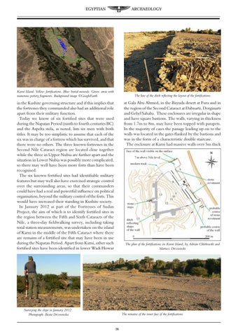
Karni Island. Yellow: fortifications. Blue: burial mounds. Green: areas with numerous pottery fragments. Background image ŠGoogleEarth
The line of the ditch reflecting the layout of the fortifications
at Gala Abu Ahmed, in the Bayuda desert at Fura and in the region of the Second Cataract at Dabnarti, Dorginarti and Gebel Sahaba. These enclosures are irregular in shape and have square bastions. The walls, varying in thickness from 1.7m to 8m, may have been topped with parapets. In the majority of cases the passage leading up on to the walls was located in the gates flanked by the bastions and was in the form of a characteristic double staircase. The enclosure at Karni had massive walls over 5m thick
in the Kushite governing structure and if this implies that the fortresses they commanded also had an additional role apart from their military function. Today we know of six fortified sites that were used during the Napatan Period (ninth to fourth centuries BC) and the Aspelta stela, as noted, lists six men with both titles. It may be too simplistic to assume that each of the six was in charge of a fortress which has survived, and that there were no others. The three known fortresses in the Second Nile Cataract region are located close together while the three in Upper Nubia are further apart and the situation in Lower Nubia was possibly more complicated, so there may well have been more forts than have been recognised. The six known fortified sites had identifiable military features but may well also have exercised strategic control over the surrounding areas, so that their commanders could have had a real and powerful influence on political organisation, beyond the military control of the forts. This would have increased their standing in Kushite society. In January 2012 as part of the Fortresses of Sudan Project, the aim of which is to identify fortified sites in the region between the Fifth and Sixth Cataracts of the Nile, a three-day fieldwalking survey, including taking total station measurements, was undertaken on the island of Karni in the middle of the Fifth Cataract where there are remains of a fortified site that may have been in use during the Napatan Period. Apart from Karni, other such fortified sites have been identified in lower Wadi Howar
The plan of the fortifications on Karni Island, by Adrian Chlebowski and Mariusz Drzewiecki
Surveying the slope in January 2012. Photograph: Beata Drzewiecka
The remains of the inner face of the fortifications
26