EGYPTIAN
Dime. One of the lions which decorated the gutters of the temple of Soknopaios. Photograph courtesy of the University of Salento studied pottery from the Priests’ quarter near the Sacred Lake. Laurent Coulon (CNRS) checked the epigraphic drawings of Osirian chapels and Laetitia Gallet undertook similar work for the Eastern Temple. In the Open Air Museum, the team led by Antoine Garric finished construction of the Netjerymenu shrine. www.cfeetk.cnrs.fr/ Western Thebes: The Univ of Arizona Egyptian Expedition, now directed by Pearce Paul Creasman, continued its excavations at the 19th Dyn female king Tausret’s ‘temple of millions of years’, located immediately N of the Temple of Merenptah. The expedition excavated the temple sanctuary (which has remained largely undisturbed since antiquity) and made significant advances in understanding post-NK occupations at the site. Evidence continues to mount that the temple of Tausret was very close indeed to completion, and a suggestion can now be offered that the sanctuary at least might have been completed before the temple was destroyed. Future work is planned for 2013 W of the temple proper to resolve outstanding questions regarding the nature of subsequent site use(s), especially what now seems to be a clear LP burial enterprise at the site. www.egypt.arizona.edu AUTUMN 2012 (October to December) Lower Egypt Buto: The DAI team, directed by Ulrich Hartung, continued work on the ED settlement enlarging the excavation area to the W to clarify the location of the entrance (or one of the entrances) of the large building complex, constructed during the second half of the 1st Dyn over earlier remains, and which was at least partly destroyed by a heavy fire in the mid-2nd Dyn. The occupation phases differ considerably regarding their architectural layouts and their pottery assemblages. So far within the new trench the continuation of the W part of the outer wall of the complex has been revealed but the area of the presumed entrance is still covered by two round Saite Period installations, probably kilns. www.dainst.org/en/project/buto Buto region: The Regional Survey around Buto (Tell el-Farain), directed by Robert Schiestl, continued work in the area between Buto and Kom el-Gir (c.5km NE of Buto) as well as at Kom el-Gir itself, where the magnetometric mapping by Tomasz Herbich, was continued (see further pp.28-29). Within the GR settlement a large rectangular enclosure with thick walls was discovered. Next to this is the corner of another structure probably a Roman fort. Between Buto and Kom el-Gir auger core drilling produced no evidence for archaeological levels at three sites (marked as small tells on early Survey of Egypt maps), nor did a small test trench to investigate a large angular feature visible on an old aerial photograph in fields between Buto and Kom elGir, and partially confirmed by magnetometry in 2011. www.dainst.org/en/node/24238?ft=all Kom el-Ahmar (Beheira): A new archaeological mission of Siena Univ, under the scientific direction of Emanuele Papi and directed in the field by Mohammed Kenawi, concentrated excavation in the central mound where the foundation of a stone structure (between 3rd ad 7th centuries AD) was
ARCHAEOLOGY
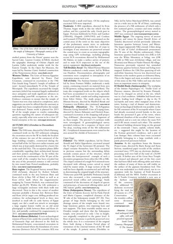
found beside a small oval basin. Of the amphorae excavated 55% were imported. Naukratis: A BM expedition, directed by Ross Thomas, began work at this site which was the earliest, and for a period the only, Greek port in Egypt. Previous fieldwork by Petrie and Gardner (1884-86), Hogarth (1899-1903) and Coulson and Leonard (1970s-80s) had concentrated on the central areas of the town so the main objectives of this preliminary season were: to undertake geophysical prospection in fields free of crops to investigate if any structures are preserved around the central area; to create an accurate topographic map using GPS technology, including plotting recent SCA excavations directed by Mohammed Ali Hakim; to make a surface survey of pottery; and to train SCA inspectors in the use of the survey equipment. http://tinyurl.com/byywtho Tell Ibrahim Awad: The Allard Pierson Museum Mission conducted a study season, led by Willem van Haarlem. Documentation, photography and restoration were completed in anticipation of an excavation season next year. Tell el-Daba: The Austrian Institute Cairo team, led by Irene Forstner Müller, undertook a study season, continuing research on material from area R/III (pottery, sealing impressions and flints). The team also reorganised work on the objects which had been accumulated in recent years, especially on the small finds, scarabs and sealing impressions from Ezbet Helmi. The study project on the Minoan frescoes, directed by Manfred Bietak and Constance von Rüden, also continued. www.oeai.at Heliopolis (Matariya): The SCA/Egyptian Museum Georg Steindorff, Univ of Leipzig team, directed by Aimen Ashmawy and Dietrich Raue, continued excavation at the shopping mall project ‘Suq el-Khamis’, discovering more fragments of an Aten temple. The precinct’s S enclosure walls were investigated. A geomorphological survey provided evidence for a sequence of layers over 9m deep, reaching strata of the 4th millennium BC. Geophysical measurements were tested in the area around the obelisk of Senwosret I. Upper Egypt Dahshur: The MMA expedition, led by Dieter Arnold and Adela Oppenheim, excavated around the N chapel of the Senwosret III pyramid. The chapel remains themselves have been excavated in previous seasons but the surrounding debris mounds contain pieces of the structure, which provides the best-preserved example of such a decorative programme from either the OK or MK. The chapel consisted of a single N-S oriented room decorated with offering scenes carved in raised relief by master artists. A large section of the W wall has been digitally reconstructed and will help in determining the original length of the structure. Thirty-one post-NK (probably Ptolemaic) burials were also excavated, a few containing partially preserved wood coffins and cartonnage. Study continued of the decoration of chapels of queens and princesses, of non-royal offering tables and of NK visitors’ graffiti. www.metmuseum.org Dime (Soknopaiou Nesos); The expedition of the Univ of Salento (Lecce), led by Paola Davoli and Mario Capasso, completed clearance of the W side of the Soknopaios temple (ST 20). Two groups of large blocks belonging to the roof drainage system of the temple were found; two large limestone gutters, two imposing lions and two supports. The lions resemble similar ones at Dendera temple and show that the Soknopaios temple, now preserved to only 1.5m in height, was originally completed to the gutter level. A floor of grey limestone is perfectly preserved over the whole area. It is a renovation of the original floor, built during a Roman Period phase of restoration of the external bottom of the W wall of the temple. A pottery survey (Neolithic to
26
NK), led by Sylvie Marchand (IFAO), was carried out in a wide area to the W of Dime, confirming the presence of a NK settlement, of which only a few scattered graves, ceramics and some artefacts survive. The geomorphological survey started in 2007 was continued. www.museopapirologico.eu/snp Middle Egypt: The ongoing survey of ancient quarries and mines by James Harrell (Univ of Toledo) discovered several previously unknown limestone quarries between Luxor and Minya. The largest (apparently NK) extends 2.6km along the N side of Gebel el-Alawanieh promontory (the N arm of the Abydos embayment). Other limestone quarries found include two (NK or LP) near the White Monastery at Sohag, one (OK or MK to NK) near el-Ghirizat village, and one (Roman) near Minya at Nazlet Hussein Ali village. Numerous previously reported but unstudied limestone quarries between Assiut and Sohag were mapped. Evidence for 12th Dyn quarrying of redand-white limestone breccia was discovered near Akhmim at the modern quarry at el-Issawia Sharq. This is the largest and most accessible occurrence of this stone in the Nile Valley and may also have been an important source in antiquity. El Sheikh Ibada (Antinoopolis): The workplan of the Istituto Papirologico «G. Vitelli» Univ of Florence mission, directed by Rosario Pintaudi, had to be changed on arrival at the site, which was in a bad condition. Sebbakhin had found some papyri, leading local villagers to dig in the N necropolis and some other marginal areas of the town, leaving a trail of disaster and destruction. Some archaeological fieldwork was possible: in the far NE extension of the N necropolis where Gayet had already excavated several burials; in the area beside the presumed E gate of the town, where additional chambers of the so-called ‘cloister’ were unearthed; and at a new site where the main N-S and E-W streets crossed each other. The number of classical building elements lying on the ground at the crossroads - bases, capitals, column shafts, etc. - suggested this might be the location of the Roman governor’s residence, and a pair of Late Antique Attic column bases were excavated probably belonging to a large vestibule with a partly preserved pavement behind. Amarna: At the expedition house the Amarna Project team, directed by Barry Kemp and Anna Stevens, transferred paper records of the artefacts excavated since 1979 into an electronic database.. processing well over half of the total of c.24,000 records. A further area of the Great Aten Temple was cleaned and planned: part of the first court that had been filled with offering tables and where the outlines of many of them are still visible on the surface of the gypsum foundation bed. This work was undertaken as a field school, run in cooperation with the Institute of Field Research (California) and the MSA. Further excavation at the S Tombs Cemetery included a new area at the furthest end of the cemetery. The additional 93 skeletons recovered bring the total for all seasons to c.370. Conservation of the wooden coffins, some decorated, continued. www. amarnaproject.com.
Amarna. A coarse mud anthropoid child coffin, with well preserved ropework. South Tombs Cemetery. Photograph © The Amarna Project