EGYPTIAN
ARCHAEOLOGY
from the gate’s original quarry at Gebel el-Silsila. http://oi.uchicago.edu/research/projects/epi/
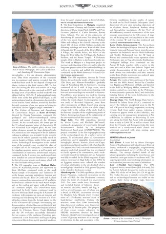
Kom el-Hettan. The northern colossus after having been re-erected. Photograph: The Colossi of Memnon and Amenhotep III Conservation Project hieroglyphic; a few are demotic administrative texts. Data from excavation of the courtyard was re-examined and analysis revealed that the tomb had been used for the disposal of corpses of plague victims in the third century AD. To that date also belong the kiln and remains of a huge bonfire (discovered in the courtyard in 2009) and the large areas of quicklime located inside the first pillared hall in 1997-98. A palaeographical study of the texts of the first pillared hall began, as did anthropological analysis of mummies discovered in recent seasons. Some of them, tentatively dated to the early centuries of our era, appear to belong to individuals of non-Egyptian origin. www.harwa.it 6. The Colossi of Memnon and Amenhotep III Conservation Project at Kom el-Hettan, directed by Hourig Sourouzian, continued the geological and archaeo-seismological survey around, and annual cleaning of, the Memnon Colossi. At the second pylon, the lower part of the N colossal quartzite statue of Amenhotep III was re-erected at its original place. At the third pylon, clearance around the large alabaster blocks was pursued and the upper part of the N alabaster colossus in alabaster was revealed. In the peristyle court, the N stela in quartzite was fully raised: its current height is 8.66m, width 3.23m and depth 1.66m. Seismological investigation in the central zone of the peristyle court revealed the place of a collapse due to an earthquake. Conservation of the standing quartzite statues, as well as study and consolidation of sandstone architectural remains, continued. In the S portico two modern pedestals were installed on cement foundations to support the feet of two red granite royal statues which will be raised in forthcoming seasons. 7. The OI epigraphic team at Medinet Habu, led by W Raymond Johnson and supervised by Brett McClain, continued work at the small Amun temple of Hatshepsut and Tuthmosis III in the barque sanctuary ambulatory (interior and exterior) and façade. Tina Di Cerbo and Richard Jasnow continued documentation of LP graffiti in the Ptolemaic additions to the small Amun temple and on the rooftop and upper walls of Ramesses III’s mortuary temple. The conservation team, supervised by Lotfi Hassan, continued work in the new blockyard built along the S Ramesses III enclosure wall, prepared an open-air museum and restoring and test-joining five sections of a 5½mtall palm column from the formal palace on the S side of Ramesses III’s temple. Inventorying and documentation of miscellaneous architectural and sculpture fragments was supervised by Julia Schmied assisted by Christian Greco. Frank Helmholz and the OI workmen successfully dismantled the last courses of the sandstone Domitian gate, constructed a new foundation and began shaping replacement blocks from newly quarried sandstone
8. The Joint Expedition to Malqata completed its third season of survey and clearance under the direction of Diana Craig Patch (MMA) and Peter Lacovara (Michael C Carlos Museum, Emory Univ, Atlanta). The site of this palace-city of Amenhotep III extends some 7km along the edge of the low desert beginning just S of Medinet Habu and ending at the cleared causeway in the desert SW of Kom el-Abd. Malqata includes the following buildings and areas: Kom el-Abd, Kom el-Samak, the W mounds of the Birket Habu, the S Village, the Middle Palace, the Palace of the King, the West Villas, the N Village, the Audience Pavilion, and the Amun Temple. A Ptolemaic temple, Deir el-Shalwit, is also located on the site. The work at Malqata is a long-term project to increase understanding of the city and to plan the long term preservation of the various buildings, as well as to complete and publish the excavations conducted by the MMA between 1910 and 1920. http://imalqata.wordpress.com/
brewery installations located nearby. A survey for rock art by Fred Hardtke (Macquarie Univ) discovered 25 new sites including depictions of an elephant, ibexes, hartebeest, Barbary sheep and hieroglyphic inscriptions. At the ‘Fort’ of Khasekhemwy essential maintenance of the new masonry concentrated at the NE corner. A large area of decaying and cracking brick in the centre of the exterior W wall was also reinforced and repaired. www.hierakonpolis-online.org Kom Ombo-Aswan region: The Aswan-Kom Ombo Archaeological Project, directed by Maria Carmela Gatto and Antonio Curci, started a rescue operation of Prehistoric sites in Wadi Kubbaniya and Sheikh Mohammed (on the W bank at Aswan) and continued the rescue operation of the Predynastic sites in Nag el-Qarmila (Kubbaniya). Geological drillings were continued on the Aswan W bank, together with a survey in the same area and at Khor Abu Subeira. Digital and artistic documentation of the rock art in West Bank Aswan was undertaken and lithic material in the Kom Ombo storeroom was analysed. www. akapegypt.org (under construction). Aswan: The work of the joint team of the Swiss Inst and the MSA Aswan, headed by Cornelius von Pilgrim and Mohamed el-Bialy, and directed in the field by Wolfgang Müller, continued. The mission carried on excavation in the PtolemaicRoman domestic quarter in Area 2 and studied the building history of the town fortification in the same area. www.swissinst.ch Kharga Oasis: The North Kharga Oasis Survey, directed by Salima Ikram (AUC), continued to survey the hitherto unexplored areas in the N and NW part of the Kharga depression, recording ceramic finds from earlier seasons, restoring a Roman-era pigeon tower at Ain Dabashiya, and carrying out a site management programme at Ain el-Lebekha. In addition to discovering 11 new sites along the Darb Ain Amur with petroglyphs from as early as 5,000 BC as well as ceramic finds from the Dynastic and Roman periods, the team worked on a newly-noted stone church and settlement associated with alum mining. www.
Elkab: The BM expedition, directed by Vivian Davies, focused on the tombs of Senwosret (early 12th Dyn) and Ahmose-Pennekhbet (probably reign of Amenhotep III). In Senwosret, cleaning continued of the E wall. A large scene, much damaged, showing the tomb-owner hunting with bow and arrow and dogs was recorded. In AhmosePennekhbet, good progress was made in cleaning and recording the decoration on the façade and within the tomb-chapel. A photographic record was made of decorated fragments, some from other monuments at Elkab, found lying among the debris on the floor. At the rear of the chapel, a large hole in the ceiling of the niche leads to the funerary complex of the neighbouring tomb of Pahery. Investigation began of the relationship of the two tombs and of their relative dating. Hagr Edfu: The BM expedition, directed by Vivian Davies and Elisabeth O’Connell, continued a programme of conservation through documentation funded by an Antiquities Endowment Fund grant (USAID/ARCE). The project completed 1) the first topographical map northkhargaoasissurvey.com of the archaeological site, 2) a surface survey of pottery, 3) architectural plans of representative SPRING (March to June) architecture and 4) epigraphic documentation of Lower Egypt hieroglyphic, hieratic, demotic, Greek and Coptic Tell Tinnis: A team led by Alison Gascoigne inscriptions and dipinti together with related motifs. (Univ of Southampton) and John Cooper (Univ of The approach to a rock-cut tomb surmounted by an Exeter) undertook a topographic, magnetometry apparent mud-brick pyramid base was investigated and sedimentological survey of this tell in Lake to clarify aspects of its construction, and a rockManzala. The surveys clarified details of the cut tomb (reused for habitation in Late Antiquity) urban topography, including the street layout, and was fully recorded. In the Elkab magazine, Coptic identified a new gate in the city enclosure wall. The ostraca excavated at Hagr Edfu in the 1980s by augering provided contextualising information on an Egyptian mission were collated; the number site formation processes and rates of subsidence. of ostraca attributable to the site doubled when a Kafr el-Sheikh Governorate: The DAI second group, identified in 2011, proved (by joins) Regional Survey around Buto (Tell el-Farain), led to be related to the known corpus by Robert Schiestl, focussed its work on an area Hierakonpolis: The BM expedition, directed by c.1km NE of the tell of Buto (see EA 40 pp.18Renée Friedman, conducted excavations on the 20). Today this area is entirely covered by fields E side of HK6, the elite Predynastic cemetery, and no archaeological remains are visible on the where the tomb of a leopard was uncovered in surface. Early Survey of Egypt maps, however, 2011. Ten more tombs were discovered and included burials of baboons, sheep, an aurochs, crocodile, ostrich and dog, as well as several humans, one of whom was a dwarf. At HK11C, excavations directed by Masahiro Baba (Waseda Univ) revealed more of a Predynastic structure made of hand-formed mud-bricks. Outside the structure, more than 1,000 intentionally shaped pieces of sandstone were discovered arranged in 23 discrete piles. The purpose of these pieces remains unknown. At HK24B, excavation directed by Izumi Takamiya (Kinki Univ) investigated one of a series of granary structures in an attempt Aswan: Overview of the excavation in Area 2. Photograph to determine its date and association to the © Swiss Institute Cairo/N Gail 30