EGYPTIAN
ARCHAEOLOGY
Digging Diary 2011-12 Dahshur: Part of the lower causeway of the Bent Pyramid and the western harbour wall. Photograph: DAI/Free University of Berlin
Summaries of some of the archaeological work undertaken in Egypt in Winter 2011-12 and Spring 2012 appear below with one report from Summer 2011. The sites are arranged geographically from north to south, ending with the oases. Field Directors who would like reports on their work to appear in EA are asked to e-mail a short summary, with a website address if available, as soon as possible after the end of each season to: patricia.spencer@ees.ac.uk PATRICIA SPENCER Abbreviations: EDP Early Dynastic Period; OK Old Kingdom; FIP First Intermediate Period; MK Middle Kingdom; SIP Second Intermediate Period; NK New Kingdom; TIP Third Intermediate Period; LP Late Period; GR Graeco-Roman; ERT Electrical Resistivity Tomography; GPR Ground Penetrating Radar; DS EES Delta Survey. Institutes and Research Centres: ARCE American Research Center in Egypt; AUC American University in Cairo; BM British Museum, London; CFEETK Franco-Egyptian Centre, Karnak; CNRS French National Research Centre; DAI German Institute, Cairo; MMA Metropolitan Museum of Art, New York; MSA Ministry of State for Antiquities, Egypt; OI Oriental Institute, University of Chicago; PCMA Polish Centre for Mediterranean Archaeology, Warsaw; SCA Supreme Council for Antiquities, Cairo: Swiss Inst Swiss Institute for Architectural Research and Archaeology, Cairo; USR CNRS research group. SUMMER 2011 (May to September) Dahshur North: The season of the Waseda Univ mission, directed by Yoshimura Sakuji and led in the field by Ken Yazawa, mainly focused on the conservation, by Richard Jaeschke, of the brightly coloured anthropoid coffin of Sobekhat (see EA
37, pp.9-12). This had been found within his boxtype coffin, in a MK shaft tomb, together with the box coffin of Senetites. The lid and base of Sobekhat’s anthropoid coffin are covered with painted gesso on a background of linen fabric stretched over a wooden frame. Both lid and base had been considerably distorted and had to be secured and realigned. WINTER 2011-12 (November to March) Lower Egypt Saqqara: The Leiden Museum/Leiden Univ expedition, directed by Maarten Raven and Christian Greco, resumed work in the NK necropolis. For security reasons, excavation was not permitted so the team concentrated on repairing damage inflicted in 2011 by plunderers in January and by heavy rain in April. The architecture and wall decoration of the tombs was largely undamaged but many modern wooden doors, protective screens and cupboards had to be repaired or replaced, and new locks fitted. Several modern roofs were renewed or adapted and new wire-mesh screens installed to keep out birds. Some restoration was undertaken in the tomb
of Pay (the lid of Raia’s sarcophagus had been cracked by robbers), the chapel of Tatia (the last fragments were repositioned on the walls and stela) and the chapel of Khay I (the ancient gypsum coating of the reliefs was stabilised). All disturbed storerooms were checked and re-organised with 120 objects and 40 relief fragments found to be missing. New digital registers were made of all finds of the past 12 years, including those now in the SCA magazines near the Imhotep Museum. www.saqqara.nl
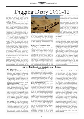
Upper Egypt Dahshur: The DAI/Free Univ of Berlin expedition, directed by Stephan Seidlmayer and Nicole Alexanian, continued work at the lower causeway of the Bent Pyramid. The trench excavated in spring 2010 was enlarged, revealing the lower end and entrance of the causeway which proved to have a total length of 148m. It ends in a large U-shaped area which is probably a harbour basin. The entrance of the lower causeway and the middle part of the W harbour wall were unearthed. The doorway of the lower causeway is only 1.40m wide and was originally closed by a wooden door. The upper end of the lower causeway, excavated by Ahmed Fakhry in 1951-55, was recleared revealing an ancient pedestrian underpass made of limestone blocks. Further limestone relief fragments from the lower temple of the Bent Pyramid were uncovered. A detailed architectural study of the lower temple was undertaken to create a 3D model. www.dainst.org/
Egypt Exploration Society Expeditions WINTER/SPRING Lake Burullus: The Delta Survey team, led by Penny Wilson (Univ of Durham), visited 16 sites; on the coast, on islands in Lake Burullus, among the fish-farms S of the Lake and in the agricultural land (see further pp.18-20). Seven sites were mapped and condition-surveyed, and surface finds were recorded. Most date to the Late Antique Period (fourth to seventh centuries AD). Along the N coast, the sites have material dating to the medieval period and later. www.ees. ac.uk/deltasurvey/ds-home.html
Tell Mutubis (Kom el-Ahmar): Penny Wilson and her team investigated this site (DS 234) S of Rosetta on the E bank of the Nile as an EES Amelia Edwards Project (see also p.20), making a detailed topographic map. The tell covers an area of c.35 hectares and is c.12m high. Surface pottery was surveyed as well as that in areas cut into the sides of the mound. Most is of the Late Antique Period, with some fragments of the first to third centuries. Features such as mud-brick and red brick walls were recorded. A drill auger survey was conducted and an assessment made of the rich archaeobotanical remains. Kom el-Daba: The Delta Survey expedition, funded by the British Academy and led by Jeffrey Spencer, continued investigation of this tell (DS 269) in Kafr es-Sheikh Governorate, excavating a large mud-brick structure in the N of the site. The external wall faces were found on the N and E sides and cleared to show the building to have been 10m x 12m. The walls had been cut by deep pits but were continuous with a high mass
(www.ees.ac.uk)
of brick from the core of the building, still standing clear of the ground. The brickwork belongs to a foundation, which was an almost solid podium of brick with very thick outer walls and perhaps a few small internal compartments. It was probably a Ptolemaic town-house with several floors, and is only one of several such ruins at the site. Similar houses probably covered a wide area arranged on crossing streets. www.ees.ac.uk/deltasurvey/ds-home. html and http://deltasurvey.tumblr.com/ Quesna: The Minufiyeh Survey team, led by Joanne Rowland (Free Univ, Berlin) continued work in the GR cemetery. Trench 9 was extended, revealing 15 graves, including one multiple burial with remains of white and coloured plaster. Two double-vessel ceramic coffins were excavated, and the first burials found at the site surrounded by fired red bricks. Another burial has traces of wood, possibly remains of a coffin. In the falcon necropolis, the results of the 2009 GPR survey were confirmed with the discovery of an additional W-E series of mud-brick corridors, with intact roofing. Rooms or niches run to the S of the corridors, and each seems to have been filled with a different offering type; some have bird mummies, others have ceramic jars with egg shells. A broken Horus stela was found and a mud-seal, probably from a ‘bird’ jar. The pottery is Ptolemaic. Sedimentary analysis of cores from Kom Usim (DS 45, see EA 39, p.4) began. http://minufiyeh.tumblr.com/ Tell Basta: The work of the EES/MSA/Univ of Göttingen expedition, led by Eva Lange, concentrated on further excavation of the
28
Ptolemaic Period casemate-building in the entrance area of the Temple of Bastet; several well preserved floor levels came to light. In the entrance hall of the Temple, epigraphic documentation continued of the Osorkon I reliefs as well as documentation of all fragments of monumental statues of the temple. The area of the cemeteries N of the temple was surveyed and photographic recording started of the decorated elite tombs of the OK necropolis. The team also began a regular lecturing programme at the MSA Zagazig Inspectorate to contribute to the training of junior inspectors.http://tellbasta.tumblr.com/ Luxor: The Theban Harbours and Waterscapes Survey, led by Angus Graham, undertook its first full season (see pp.21-24). Ten ERT profiles were carried out in floodplain areas in front of the memorial temples stretching from Tuthmosis III in the N to Amenhotep III in the S and ranging from 96m to 720m in length and up to 19.5m in depth, to locate any canals that may have served these temples. ERT, magnetometry and hand-augering confirmed the presence of a large rectilinear feature in the floodplain marked on Gardner Wilkinson’s 1830 map, c.400m E of the Ramesseum. An ERT profile and augering in the entrance to Birket Habu and another profile through the possible ceremonial lake on the E bank began investigation of these two massive projects. Two long 32m-deep ERT profiles through the Amun-Re complex at Karnak continue developmental research there. http:// eestheban.tumblr.com/