EGYPTIAN
ARCHAEOLOGY
barge-horses; sometimes punting for hours, which is the hardest work of all …’. Even though Edwards was on a tourist vessel, her experience seems to be typical of Nile journeys. The Southampton-born Richard Pococke travelled up the river on a more generic Nile cargo vessel a century earlier. He noted not only that his crew regularly towed the vessel from the Nile bank, but that they continued to do so even during the Muslim fasting month of Ramadan. Together with hard labour came danger. Grounding incidents were not only inconvenient; they were also dangerous. A sailing vessel hitting a sandbank could easily capsize, as the English barrister Eliot Warburton discovered in the nineteenth century, when his craft halfoverturned. When the Christian pilgrim Jean Coppin arrived in Egypt in 1638, he learned that a storm had just sunk 80 vessels on the Nile. In the nineteenth century, Florence Nightingale saw even a dhahabiyya overturned as the result of a storm whipped up by a southerly khamsin wind. Particular locations caused particular problems. At the northern extremes of the river, the Nile’s Mediterranean mouths created their own risks: shifting river-mouth deposits of sediment made for narrow and shifting channels, from which the prevailing northwesterlies could easily blow a vessel - not least when waves from the sea met both the shallows and the outpouring river. ‘The waters of the river combat with the sea to find a passage’, says the eighteenth century traveller Claude Savant, ‘When the winds freshen, the waves then run mountain-high, and form whirlpools, which swallow up vessels’. At Egypt’s southern extreme, it was a navigational obstacle - the First Cataract - that marked the historical border of the country. These rapids could be crossed at high Nile, but only with the expertise of a local pilot. Between these northern and southern extremes, the hazards were more generic than specific to a location. But
A dhahabiyya on the Nile near Cairo, by Fielder (1876)
this was not always the case. At the mountain of Gebel Abi Foda, near Asyut, the Nile presses against the river cliff. The current runs faster, and the mountain induces tricky cross winds. For medieval authors, it was the abode of witches. When Amelia Edwards passed the mountain, crosswinds drove her vessel into the muddy river bank, where it joined twelve others already trapped. Maritime archaeologists have often resorted to experimental archaeology as a means of better understanding the navigational landscapes of the past. Observing the handling and behaviour of, say, a reconstructed Viking ship or a sewn-planked vessel can greatly boost our understanding of navigation in the northern Atlantic or western Indian Ocean. But the Egyptian Nile has been so radically transformed by human engineering over the past 150 years that no amount of reconstruction can replicate the navigational conditions encountered by Egyptians in the past. Fortunately, Egypt has exercised such a draw on visitors that a substantial corpus of travel literature exists, and from this we can start to build an understanding of Nile navigation across all periods. Of course, not everything was the same across time. Waterways came and went, and the climate has changed to some extent. But judicious use of travel, meteorological and hydrological data can nevertheless shed valuable light on what it was like to navigate the Nile in the past. What these accounts reveal is that navigation before the building of the dams was highly seasonal, and that it required hard labour and a much more extensive expertise than has often been credited to it. This insight is important in its own right, because it helps us to understand the past lives of a great many ordinary Egyptians. But it also helps us to understand the making of the wider landscape. Alexandria, for example, is a fine sea-port, but it is isolated from the Nile. Efforts to keep it connected it to the Nile via canal can only be understood if we appreciate why mariners didn’t simply sail in and out of the nearest Nile mouth, ignoring Alexandria altogether. It is in addressing issues such as these that the experiences and encounters of the Nile’s past travellers become so very valuable. q John P Cooper is a Lecturer in Arab Studies and Islamic Material Culture at the University of Exeter. His book on the navigational landscape of the medieval Nile is due for publication in 2013.
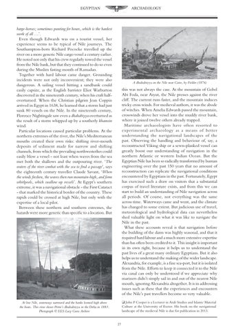
At low Nile, waterways narrowed and the banks loomed high above the boats. This view shows Petrie’s dhahabiyya in the Delta in 1883. Photograph © EES Lucy Gura Archive 27