EGYPTIAN
ARCHAEOLOGY
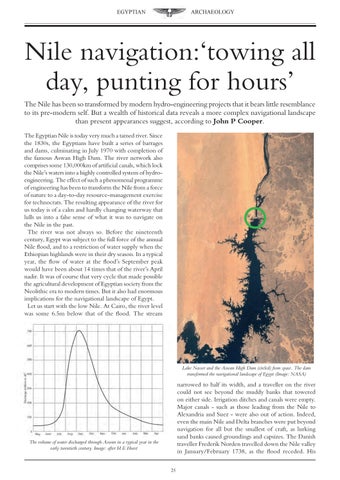
Nile navigation:‘towing all day, punting for hours’ The Nile has been so transformed by modern hydro-engineering projects that it bears little resemblance to its pre-modern self. But a wealth of historical data reveals a more complex navigational landscape than present appearances suggest, according to John P Cooper. The Egyptian Nile is today very much a tamed river. Since the 1830s, the Egyptians have built a series of barrages and dams, culminating in July 1970 with completion of the famous Aswan High Dam. The river network also comprises some 130,000km of artificial canals, which lock the Nile’s waters into a highly controlled system of hydroengineering. The effect of such a phenomenal programme of engineering has been to transform the Nile from a force of nature to a day-to-day resource-management exercise for technocrats. The resulting appearance of the river for us today is of a calm and hardly changing waterway that lulls us into a false sense of what it was to navigate on the Nile in the past. The river was not always so. Before the nineteenth century, Egypt was subject to the full force of the annual Nile flood, and to a restriction of water supply when the Ethiopian highlands were in their dry season. In a typical year, the flow of water at the flood’s September peak would have been about 14 times that of the river’s April nadir. It was of course that very cycle that made possible the agricultural development of Egyptian society from the Neolithic era to modern times. But it also had enormous implications for the navigational landscape of Egypt. Let us start with the low Nile. At Cairo, the river level was some 6.5m below that of the flood. The stream
Lake Nasser and the Aswan High Dam (circled) from space. The dam transformed the navigational landscape of Egypt (Image: NASA)
narrowed to half its width, and a traveller on the river could not see beyond the muddy banks that towered on either side. Irrigation ditches and canals were empty. Major canals - such as those leading from the Nile to Alexandria and Suez - were also out of action. Indeed, even the main Nile and Delta branches were put beyond navigation for all but the smallest of craft, as lurking sand banks caused groundings and capsizes. The Danish traveller Frederik Norden travelled down the Nile valley in January/February 1738, as the flood receded. His
The volume of water discharged through Aswan in a typical year in the early twentieth century. Image: after H E Hurst
25