EGYPTIAN
ARCHAEOLOGY
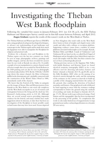
Investigating the Theban West Bank floodplain Following the curtailed first season in January-February 2011 (see EA 38, p.3), the EES Theban Harbours and Waterscapes Survey carried out its first full season between February and April 2012. Angus Graham reports the results of this season’s work on the West Bank at Thebes. The Theban Harbours and Waterscapes Survey (THaWS) aims, using geophysical and geoarchaeological techniques, to advance our understanding of past landscapes and waterscapes in the Theban region and to study how much the Egyptians were able to manipulate the floodplain for religious and practical ends. Evidence for a dynamic river and floodplain in the Theban region over the last two centuries can clearly be seen in maps, photographic archives, paintings and satellite imagery, and has also been revealed for ancient times by our work at Karnak (see also p.16). A notable example of recent manipulation is a minor channel south of Luxor temple that was recorded by David Roberts in his 1838 painting and can also be seen in photographs (see below) taken before 1872. By the 1940s the 1:25,000 map shows this minor channel, the Khor el-Ammari, infilled at the downstream end - probably connected with the construction of the Winter Palace Hotel in 1886, immediately south of the channel. We know that the Festival of the Valley in antiquity saw the images of Amun, Mut and Khonsu journey from Karnak to the West Bank to visit royal cult complexes and the West Bank necropolis in an act of reunion and reintegration between the living and the dead (see Ute Rummel’s forthcoming article in EA 42). Although there are several textual sources providing important evidence for the festival, and many scholars have made suggestions about its itinerary, to date there has been no investigation of the floodplain to locate possible canals or land routes that may have been used. Scenes depicted
on New Kingdom elite tomb walls on the West Bank show basins in front of temples and chapels (some with canals) and often with a tribune or reception platform. Supporting evidence comes from a number of extant platforms associated with temples at, for example, Karnak, Medinet Habu and ElKab. Canals of Tuthmosis I and Tuthmosis III are listed on the so-called Red Chapel of Hatshepsut and are thought to have linked their respective royal cult temples with the Nile, but their existence has not yet been archaeologically proved. During previous surveys in the Egyptian Nile Valley with Judith Bunbury and Kristian Strutt we found electrical resistivity tomography (ERT) to be a very effective tool for detecting sub-surface features and former channels at Karnak (EA 36, pp.25-28) and in the Edfu floodplain. ERT relies on the passing of an electrical current through the earth, and the measuring of the resistance to the current at intervals to build up a profile of the changing material below the surface of the ground, thus enabling the detection of localised anomalies and features. Our geophysical work is followed by hand augering to assess what the resistance readings corresponded to below the ground using the methods of recording and study developed at Karnak (EA 27, pp. 17-19). All our work is geo-referenced using a Total Station and the topographic data has been incorporated in the processing of the profiles. To complement this work we also make limited use of magnetometry to map potential near-surface archaeological features in a broader 2D area survey.
This photograph taken by Antonio Beato some time before 1872 shows the waterway, Khor el-Ammari, rejoining the Nile to the south of the Temple of Luxor. Photograph (the sky has been cropped): Image no.3456, reproduced with permission of the Griffith Institute, University of Oxford
An unsigned photograph taken facing south from the Temple of Luxor some time before 1872 shows the waterway, Khor el-Ammari, rejoining the Nile. Photograph (the sky has been cropped): image no.3460, reproduced with permission of the Griffith Institute, University of Oxford 21